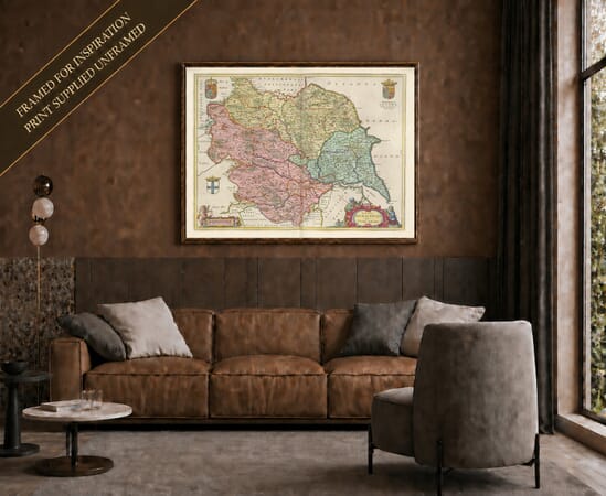
Joan Blaeu’s Map of the East Riding of Yorkshire
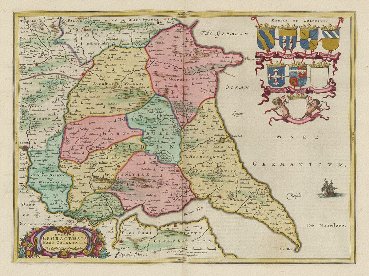
Joan Blaeu’s map of the East Riding of Yorkshire was first published in Amsterdam in 1645. Its engraved title, Ducatus Eboracensis Pars Orientalis; The Eastriding of Yorkeshire, identifies it as the eastern division of the historic county of Yorkshire.
The map appeared in the fourth volume of Blaeu’s Theatrum Orbis Terrarum, sive Atlas Novus, devoted to England and Wales. Alongside a general map of the complete county, Blaeu produced separate plates for the North, East and West Ridings. These more focused maps allowed him to record Yorkshire’s numerous settlements, rivers and varied landscapes in considerably greater detail.
Blaeu’s English County Maps
Joan Blaeu assumed responsibility for the family publishing house following the death of his father, Willem Blaeu, in 1638. The East Riding map belongs to Joan’s period of leadership and should therefore be attributed to him rather than to Willem.
Blaeu did not undertake a new survey of the region. The geographical content of his Yorkshire maps was based largely upon earlier English cartography, particularly the county maps of John Speed and the surveying tradition established by Christopher Saxton. The Amsterdam workshop refined and re-engraved this information, combining it with the elaborate decoration expected by purchasers of a prestigious seventeenth-century atlas.
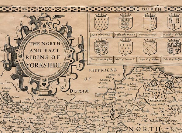
An interesting comparison can be made with our old map of Yorkshire’s North and East Ridings by John Speed. Speed combined both Ridings on one plate, whereas Blaeu gave the East Riding its own separate map.
The Historic East Riding
Yorkshire’s traditional division into three Ridings had ancient Scandinavian origins. The word “Riding” developed from an Old Norse term meaning a third part, reflecting the lasting influence of Viking settlement and administration in the region.
The East Riding extended eastwards from the vicinity of York towards the North Sea and southwards to the Humber Estuary. The River Derwent formed much of its boundary with the North Riding, while the Ouse and Humber separated it from the West Riding and Lincolnshire.
The landscape is dominated by the arc of the Yorkshire Wolds, a range of gently rolling chalk hills extending from the Humber towards Flamborough Head. To the east lies Holderness, an area of fertile but low-lying ground between the Wolds and the sea. Farther west are the flatter lands adjoining the Vale of York.
Blaeu represents hills pictorially rather than through measured contours. Woodland appears as groups of individual trees, while towns and villages are marked with conventional building and church symbols. Roads are not systematically recorded, so the engraving should not be interpreted as a modern travelling map.
Towns, Rivers and the Coast
Beverley was the traditional administrative and ecclesiastical centre of the East Riding. Its medieval minster, markets and connections with the surrounding agricultural district gave it considerable regional importance.
Kingston upon Hull occupies a strategically important position beside the Humber. By the seventeenth century it was an established port trading with northern Europe and the Baltic, importing timber, iron and other goods while exporting agricultural produce and manufactured wares.
Other identifiable settlements include Bridlington, Driffield, Pocklington, Market Weighton, Howden, Hedon and Hornsea. Numerous villages are recorded using spellings that sometimes differ considerably from their modern forms.
The River Hull and its tributaries connect the northern parts of Holderness with the Humber, while the Derwent defines much of the western and northern geography. The Humber itself provided access to the North Sea and to the navigable rivers leading deep into northern England.
A sailing ship engraved offshore reinforces the East Riding’s maritime character. Its coast included fishing communities and trading havens, although exposed shores and shifting sediments presented continual challenges. The Holderness coast has long been affected by erosion, while Spurn Head at the mouth of the Humber has repeatedly changed its form.
Agriculture, Markets and Maritime Trade
The East Riding shown on this antique map was predominantly rural. Farming, grazing and the movement of produce through local markets supported much of its economy. The chalk soils of the Wolds, the richer agricultural land around Beverley and the lower country of Holderness each encouraged different patterns of cultivation and settlement.
Drainage remained an important concern in the marshier districts. Later improvements would transform substantial areas of low-lying land, but Blaeu’s map records the region before modern drainage schemes, turnpike roads and railways altered its appearance.
Hull’s maritime commerce linked this agricultural hinterland with wider markets. Beverley also maintained access to the River Hull through Beverley Beck, allowing goods to be transported between the town, the Humber and the North Sea.
The East Riding During the Civil War
The map’s publication date gives it a particularly significant historical setting. In April 1642, shortly before the formal outbreak of the First Civil War, the governor of Hull refused King Charles I entry to the town. Hull contained an important arsenal, and control of its weapons and supplies was of great strategic importance.
Royalist forces subsequently attempted to capture Hull, but the town remained in Parliamentarian hands. Fighting and military movements affected other parts of Yorkshire before the decisive Parliamentarian victory at Marston Moor in July 1644.
Blaeu’s map does not record these events directly. It was designed as a geographical and decorative work rather than a military map, presenting a calm and orderly image of a region that had recently experienced considerable disruption.
Heraldry and Decorative Engraving
The title appears within an ornamental cartouche, while eight family coats of arms form an impressive heraldic display. Two shields were left blank, and two cherubs accompany the arrangement. A sailing ship provides a maritime counterpoint to the decoration on land.
Original maps were printed in black ink from an engraved copperplate, with colour added separately to selected impressions. Surviving examples may also carry Latin, French, Dutch or German text on the reverse, depending upon the atlas edition in which they appeared.
More than three and a half centuries later, Blaeu’s map remains an absorbing record of East Yorkshire before modern roads, railways and large-scale drainage reshaped the region. It combines local history and geographical detail with the decorative artistry of Dutch Golden Age mapmaking.





 Verified owner