Verified owner
Got there in time and loves it! Cheers David [Gift from US to UK]
 Verified owner
Thanks Lauren. We received it today - it's gorgeous! Thank you, Ellan
 Verified owner
Thank you for your prompt service. I have a gallery and framing business in South Wales. I'm so pleased it is printed in the UK
 Verified owner
My Isles of Scilly map arrived safely and I'm delighted with it!

The print arrived safely and we're delighted with it - a lovely reminder of our honeymoon 15 years ago.
 Verified owner
I have just received them! I'm sure our clients will be pleased with them and there could be more projects off the back of this one where we can use more. [Interior Designers]
 Verified owner
I just received my map of Ireland by Ewart today and, as usual, I am delighted by its quality. The crispness and fineness of detail is excellent and the colour reproduction surpasses my expectations. Please relay my thanks to Steve for another fine effort!
 Verified owner
Many thanks, Lauren. Very pleased with the map and the service: would recommend The Old Map Company to anyone interested in Old Maps.
 Verified owner
Many thanks, the map arrived safely this morning, and I’m really pleased with it. A stunning reproduction, just as I had hoped. I will keep browsing your website, and may yet be tempted by more of your items! Have a great weekend.
 Verified owner
Just arrived, wonderful map! Thanks very much!
 Verified owner
The map – beautiful – arrived safely, very many thanks.
 Verified owner
Thank you, I have already found the map. It’s wonderfull! Good luck! Rasa
 Verified owner
My apologies for the very late reply. I wanted to reach out to thank you so much for rushing my order. My partner absolutely loved it. I am amazed with the service so that is a five-star from me. I wish you all the best.
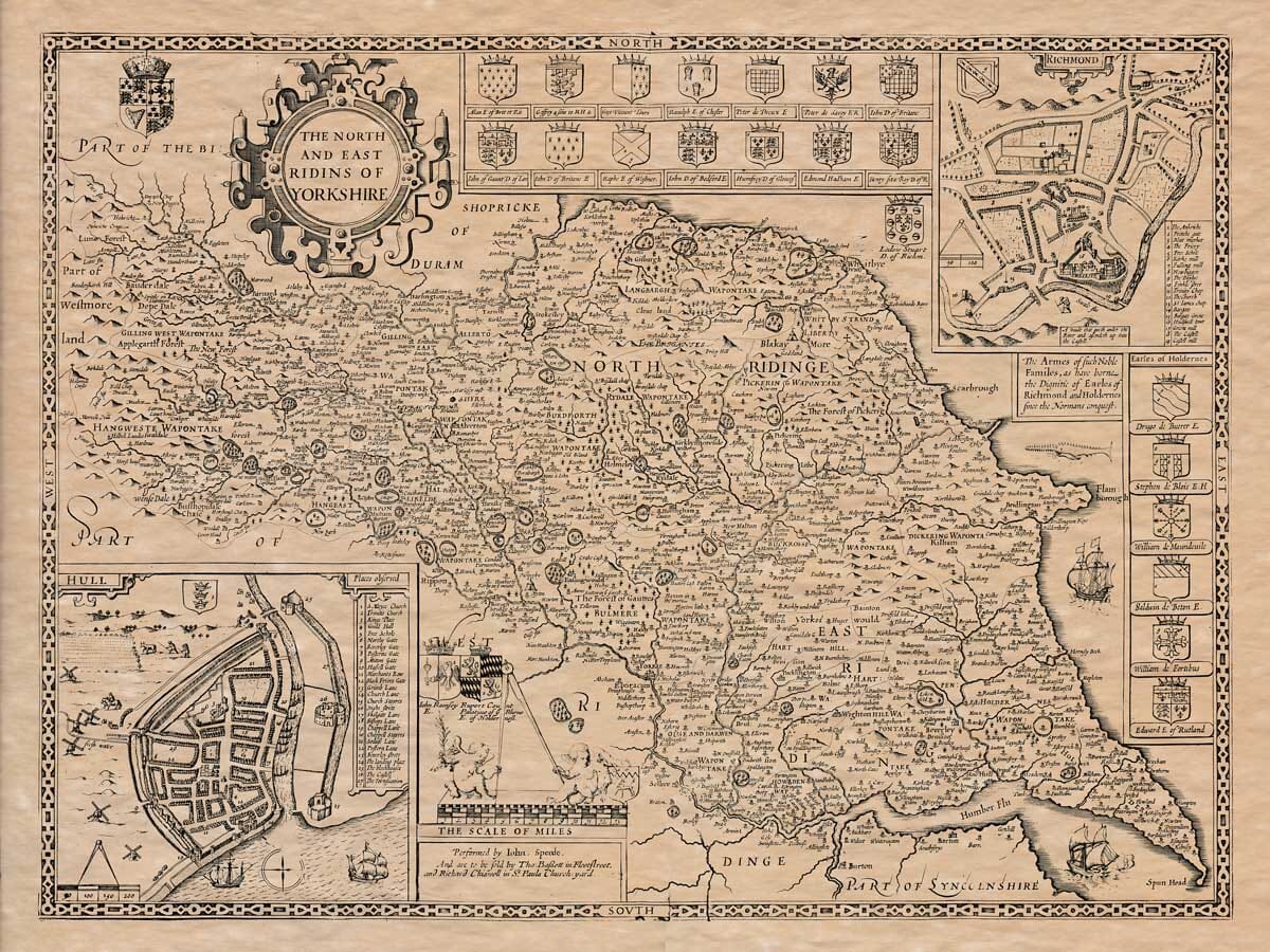
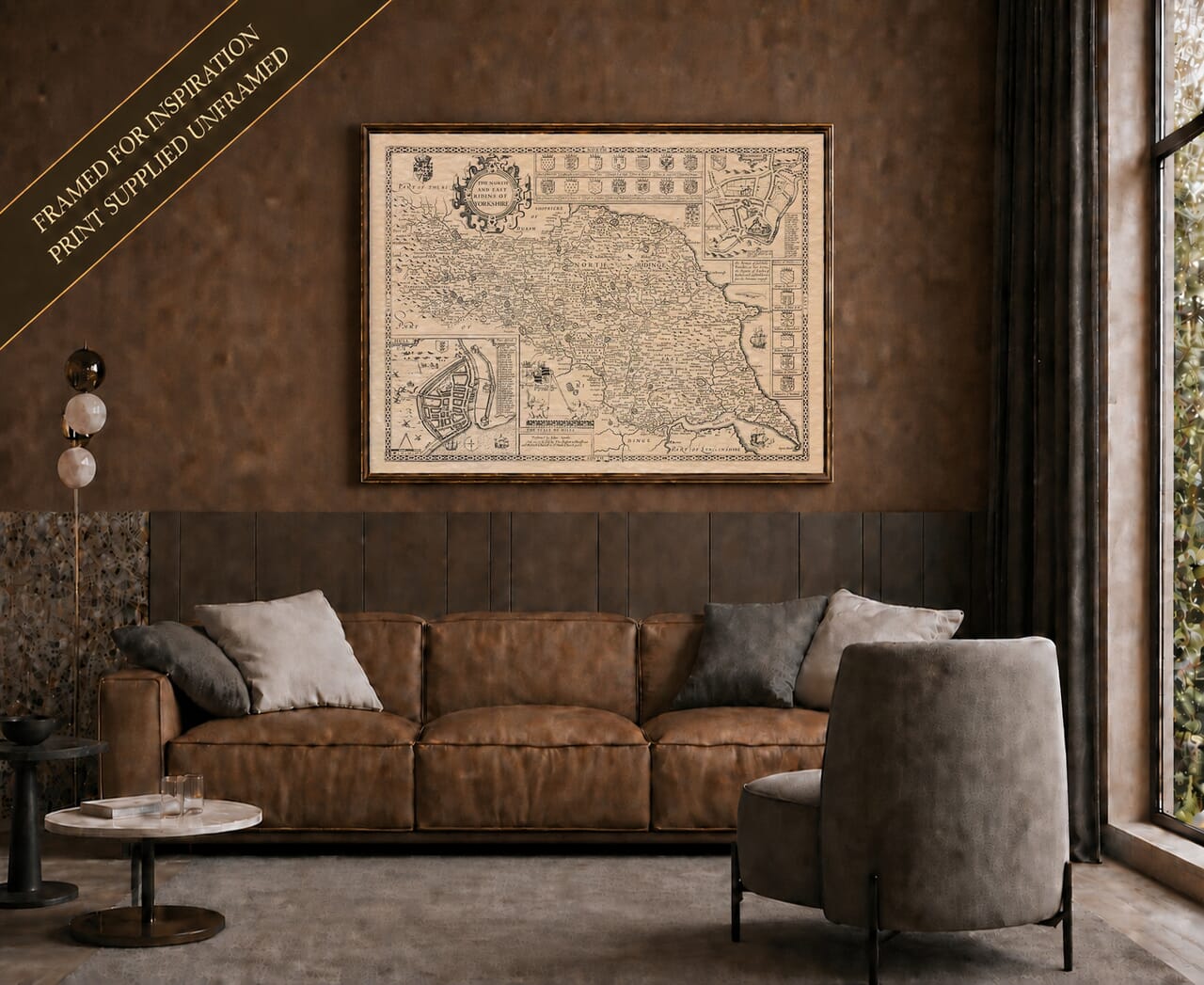
John Speed’s map of Yorkshire’s North and East Ridings is one of the most intricate county engravings produced for The Theatre of the Empire of Great Britaine. The map was first prepared during Speed’s lifetime and appeared in the earliest editions of his celebrated atlas during the opening decades of the seventeenth century.
The impression reproduced here belongs to the later edition published by Thomas Bassett and Richard Chiswell in 1676. Their names appear beneath the scale, confirming that this is not an impression from the map’s earliest state.
For centuries, Yorkshire was divided into three Ridings: North, East and West. The word derives from an Old Norse term meaning a third part, reflecting the Scandinavian influence that shaped Yorkshire’s language and administration.
Speed devoted one map to the county as a whole, one to the West Riding and this separate plate to the North and East Ridings. The arrangement allowed him to present an exceptional number of settlements and geographical features without sacrificing the decorative qualities for which his maps became renowned.
The North Riding stretches from the Pennine country around Richmond eastwards to the coast at Whitby and Scarborough. The East Riding occupies the lower part of the engraving, extending through the Yorkshire Wolds and Holderness towards Beverley, Hull, Spurn Head and the Humber.
Richmond appears prominently in the north-western country, close to the River Swale. The surrounding landscape is filled with hills, river valleys, forests, castles and small communities leading towards Wensleydale and the higher Pennine country.
An inset town plan in the upper-right corner presents Richmond in greater detail. Richmond Castle dominates the settlement, with streets, gates, churches and principal buildings identified through a numbered reference.
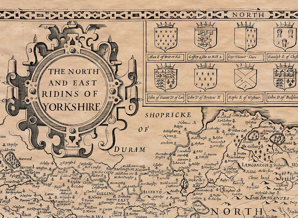
Farther east, Northallerton and Thirsk stand among a dense network of villages and rivers. The old wapentake names—including Gilling, Hang East, Hang West, Birdforth and Allerton—divide the North Riding according to its historic system of local administration.
Speed’s pictorial hills are not measured contours, but they convey the changing character of the land. The rugged western valleys gradually give way to the Vale of Mowbray before the country rises again towards the North York Moors.
The North Sea coastline is followed from the Tees southwards past Whitby, Scarborough and Filey. Numerous smaller coastal settlements appear along cliffs, bays and river mouths.
Whitby is closely associated with its medieval abbey and its position beside the River Esk. Scarborough is shown farther south, already an established harbour and market town beneath its castle.
Sailing vessels animate the sea, while a curious marine creature appears near the coast. These additions are decorative, but they also acknowledge the importance of fishing, coastal trade and navigation to the communities of eastern Yorkshire.
The map records Middlesbrough as a very small settlement, long before nineteenth-century industry transformed it into a major town and port. This provides a particularly striking example of how dramatically the region changed after Speed’s period.
The East Riding is organised around the gently rolling Yorkshire Wolds and the lower country extending towards Holderness. Beverley is prominently marked inland from Hull and was one of the region’s most important religious and commercial centres.
Market Weighton, Pocklington, Driffield and Bridlington appear among hundreds of villages, churches and estates. The hilly symbols of the Wolds contrast with the flatter country beside the Humber and the low-lying coast of Holderness.
The River Derwent creates an important geographical division between parts of the North and East Ridings. Other waterways, including the Ouse, Hull and Esk, provide a framework through which the towns and settlements can be followed.
Kingston upon Hull receives the largest of the two inset plans. The town is shown enclosed by defensive walls beside the River Hull, immediately before it reaches the Humber.
Streets, gates, churches, the market place and harbour installations are recorded and numbered. Ships approach the town from the estuary, emphasising Hull’s role as one of England’s most important eastern ports.
The inset captures Hull before later docks, industrial development and suburban expansion transformed its waterfront. Its compact walled plan provides a vivid contrast with the extensive modern city.
A procession of coats of arms extends across the upper border. These commemorate noble families and title holders associated with Richmond and the surrounding country.
Additional shields appear beside the Hull and Richmond plans and along the eastern border. Together with the title cartouche, ships, compass markings, scale bar and pictorial landscape, they turn the map into a statement about Yorkshire’s history as well as its geography.
The engraving rewards close examination. Familiar towns stand beside villages whose names preserve seventeenth-century spellings, while castles, parks, woods and river crossings reveal the older structure of the countryside.
Published more than three centuries ago, Speed’s map remains an absorbing portrait of northern and eastern Yorkshire. For anyone with connections to Richmond, Northallerton, Whitby, Scarborough, Beverley, Hull or the surrounding countryside, it offers an extraordinary journey through a recognisable landscape seen through seventeenth-century eyes.
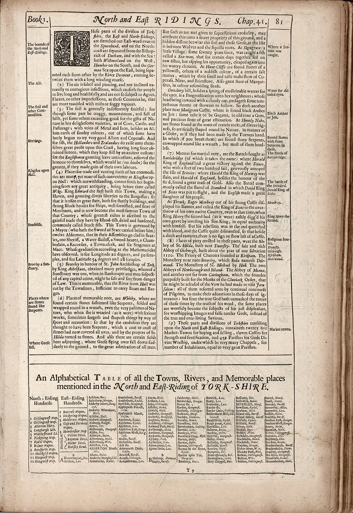
Speed’s notes on the verso of the atlas page featuring the North and East Ridings.
The following translation from the original Olde English may contain some errors.
(1) These areas are part of the division of Yorkshire — the East and North Ridings. They stretch eastward all the way to Spurn Head and are separated on the north coast from the Bishopric of Durham by the sea. They border Westmorland to the west, the Humber to the south, and the North Sea to the east. The River Derwent, winding through the land, divides the East and North Ridings.
(2) The air here is sharp and clear, and not naturally prone to contagious diseases. As a result, people tend to live long and healthy lives, and are less likely to suffer from fevers, dysentery, or other common ailments found in mistier, damper regions.
(3) The soil is generally of moderate fertility. While some areas are rocky and mountainous, others are rich in natural beauty and resources, offering good crops, livestock, and pastures. There are also veins of metal and iron, and colourful alum-rich earth, which has recently been used to produce good-quality alum and copperas. The coast is rich in fish, which the Dutch and Zeelanders profit from greatly, having long held fishing rights there. Though the English granted them permission, they kept the honour to themselves — and would surely gain more if they reaped the profits of their own waters.
(4) There are many places for trade, but none as convenient as Kingston upon Hull. This town, which wasn’t known in ancient times (formerly called Wike), was built by King Edward I. He created a harbor and granted privileges to its citizens. Since then, Hull has grown in prominence, with grand buildings, strong fortifications, well-equipped ships, and a large population of merchants. Its wealth mainly comes from its trade in dried fish from Iceland, commonly known as stockfish. The town is governed by a mayor (who carries the Sword of State), twelve aldermen in scarlet, a sheriff, a water-bailiff, a sword-bearer, a chamberlain, a recorder, a town clerk, and six sergeants-at-mace. According to mathematicians, it lies at 20°30′ longitude and 54°28′ latitude.
(5) Beverley, in honour of Saint John, Archbishop of York, was granted many privileges by King Athelstan, including the right of sanctuary — where debtors and those accused of serious crimes could find safety from the law. Notably, the townspeople also cut a canal from the River Hull to Beverley, navigable by boats and barges.
(6) Notable places include Whitby, where stones shaped like coiled serpents are found — seen by some as nature’s playful work, and by the superstitious as actual serpents turned to stone by the prayers of Saint Hilda. Nearby, geese flying overhead are said to suddenly fall from the sky, puzzling all observers.
Skeptics, however, believe it is due to a unique property of the soil, much like wolves avoid certain plant roots.
At Skengrave (a small village), about seventy years ago, a sea creature called a “sea-man” was caught and fed on raw fish for a few days before escaping back into the sea.
At Huntcliff, stones of yellowish or reddish color are found, which smell and taste like copperas, saltpeter, and brimstone. There are also many “marcasites,” which look like brass.
Ounsbery Hill has a spring believed to be good for eye conditions. When its peak is covered in clouds, it foretells storms or rain. Near Mulgrave Castle, black amber (also called jet) is found — once considered a precious gem.
At Huntly Nabo, naturally round stones are found under rocks, shaped like globes, as if turned by a craftsman. When broken open, they sometimes reveal stone “serpents” coiled inside, though most are headless.
(7) Military history includes the battle at Battlebridge, named after a great victory by King Harold of England over the Danes, who had come with 200 ships and heavily attacked Britain. Harold of Norway was killed, and King Harold of England found a large treasure of gold.
Also, at the Battle of the Standard, King David of Scotland was defeated, and many Scots were killed.
At Thirsk, Roger Mowbray raised his banner from his strong castle and invited the King of Scots to invade England at a time when King Henry II had unwisely made his son co-king. This rebellion was eventually crushed, the castle dismantled, and now only a ditch and earthen wall remain.
(8) Religious sites once found in the area include the Abbey of Saint Hilda near Dunseley, the rich Gisborough Abbey (built around 1110 AD), the Priory at Kirkham, the monastery near Beverley (called Deirwand by Bede), Saint Michael’s Monastery by Hull, the abbeys of Newborough and Byland, Meaux Abbey, and another near Cottingham built for Cluniac monks — founded by a man wishing to be released from his vow to visit Jerusalem. These places drew many pilgrims in those earlier, superstitious times. But since the truth of the Gospel has been revealed, such sites — once devoted to image worship and false saints — now rightly suffer God’s displeasure.
(9) These North and East Ridings of Yorkshire include 25 market towns for trade, 11 castles for defence, and 459 parishes for religious worship — many of which include chapels that serve populations as large as full parishes.