W. B. Clarke’s Old Map of Vienna
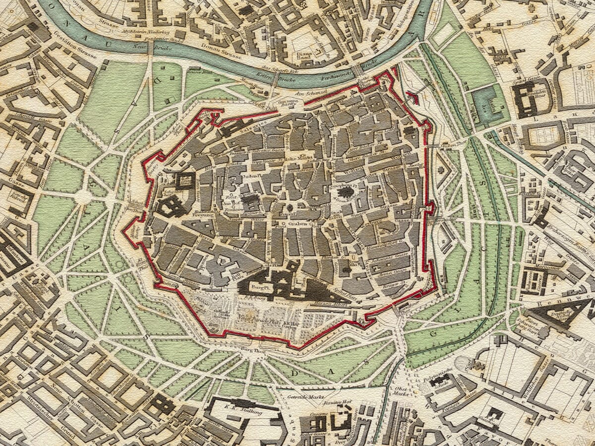
This detailed plan of Vienna was published in London in 1833 under the direction of the Society for the Diffusion of Useful Knowledge. Drawn by the architect and cartographer W. B. Clarke, it was engraved and printed by J. Henshall and issued by Baldwin & Cradock.
The Society was founded to make reliable educational material available at an affordable price. Its maps consequently favoured clarity, careful lettering and useful geographical information over extravagant decoration. Clarke’s plan is nevertheless an exceptionally attractive engraving, combining a precise street map with restrained hand colouring and a sequence of architectural views.
Map Details
- Original title: Vienna (Wien)
- Cartographer: W. B. Clarke
- Engraver and printer: J. Henshall
- Published for: Society for the Diffusion of Useful Knowledge
- Publisher: Baldwin & Cradock
- First published: London, 1833
- Later atlas issue: Chapman & Hall, 1844
- Approximate scale: 1:16,000
- Region shown: Vienna’s fortified centre, surrounding suburbs and adjoining Danube landscape
- Principal features: City walls, bastions, glacis, Linienwall, streets, gardens, Danube channels and the Prater
- Lower border: Twelve elevations of notable Viennese buildings
- Format: Engraved city plan with hand-applied colour
Vienna Before the Ringstrasse
The publication date is central to the map’s interest. In 1833, Vienna still retained the defensive form that had shaped it for centuries. The densely built historic centre occupies the middle of the engraving, enclosed by a formidable circuit of walls, projecting bastions and angular outworks.
Around these fortifications lies a broad open belt. This was the glacis, kept largely free from permanent construction so that defenders could command an unobstructed field around the walls. By Clarke’s time it also contained roads, walks and planted ground, creating a striking visual separation between the old city and its suburbs.
That landscape soon disappeared. Emperor Franz Joseph ordered the demolition of the fortifications in 1857, allowing the Ringstrasse and its monumental public buildings to be constructed across the former defensive zone. Clarke’s map therefore records the centre of Vienna less than a quarter of a century before one of Europe’s most ambitious programmes of urban redevelopment began.
Modern landmarks associated with the Ring—including the State Opera, Parliament, Rathaus and the later university buildings—are consequently absent. In their place, the map shows the walls and open ground upon which the new imperial city would be built.
The Inner City and Its Bastions
Within the fortifications, the Innere Stadt appears as an extremely dense network of narrow streets, courts and building plots. St Stephen’s Cathedral is one of the most recognisable structures, rising from the closely packed medieval centre.
The Hofburg complex occupies a commanding position beside the western defences. Its courtyards and adjoining gardens contrast with the smaller buildings clustered through the commercial and residential streets.
The bastions are drawn individually, allowing their relationship with gates, roads and the surrounding glacis to be followed. Their heavy angular geometry gives the historic centre an almost star-shaped outline, markedly different from the softer circular form created by the later Ringstrasse.
Suburbs Beyond the Walls
The old centre formed only one part of the Vienna represented in 1833. Large suburbs had developed beyond the glacis, each with its own streets, churches, gardens and concentrations of buildings.
Leopoldstadt lies across the Danube Canal to the north. Landstraße spreads eastwards, while Wieden, Mariahilf, Neubau, Josefstadt and Alsergrund occupy the country south and west of the fortified city. Their names and street patterns remain recognisable, although subsequent rebuilding greatly increased their density.
These suburbs were not yet incorporated into Vienna as the numbered inner districts familiar today. That administrative expansion came in 1850. Clarke’s plan therefore captures the communities while they were physically connected to the capital but still visibly distinct from its enclosed historic centre.
The Linienwall
A red, angular boundary surrounds much of the outer city. This represents the Linienwall, an earthwork and defensive line constructed during the early eighteenth century. It also became an important customs boundary, with goods entering the suburbs subject to taxation at its gates.
The Linienwall explains the sharply defined outer edge visible across the southern and western parts of the map. Roads pass through it at controlled points, while fields and comparatively open land begin immediately beyond.
Later urban expansion carried Vienna far outside this boundary. The wall was eventually demolished in the 1890s, and the Gürtel developed along much of its former course. Its prominence on the engraving makes it one of the most useful features for comparing the city of 1833 with Vienna today.
The Danube, Canal and Prater
Water dominates the northern part of the plan. The Danube had not yet been confined to the regulated channel created later in the nineteenth century. Instead, waterways divide and curve around islands, low ground and developing neighbourhoods.
The Danube Canal runs beside the old city and separates it from Leopoldstadt. Bridges provide essential connections between the fortified centre, the northern suburbs and the roads leading farther into the Austrian Empire.
East of Leopoldstadt lies the Prater, represented by long tree-lined avenues, open ground and scattered buildings. Its spacious appearance contrasts dramatically with the tightly packed streets on the opposite side of the canal.
These rivers and open landscapes are not incidental decoration. They show how Vienna’s development was governed by crossings, flood-prone ground, fortifications and the availability of land beyond the historic centre.
Architectural Views Along the Border
A sequence of twelve small architectural elevations runs along the bottom of the engraving. Churches, palaces and public buildings form a miniature panorama beneath the city plan.
These views help the reader connect the abstract shapes on the map with Vienna’s architectural identity. They also provide an ornamental finish without distracting from the plan itself, reflecting the Society’s preference for decoration that carried an educational purpose.
The combination of street-level precision and architectural illustration makes the map rewarding at both a distance and close quarters. From afar, the walled centre and surrounding suburbs create a powerful composition; examined closely, individual streets, gardens, buildings and routes become visible.
Published in 1833, this historic map preserves Vienna at the end of its fortified era. It records the city before the Ringstrasse, before the incorporation of the inner suburbs and before Danube regulation altered the northern landscape—a Vienna poised between its old defensive form and its emergence as a modern imperial capital.







 Verified owner












