Abraham Ortelius’s Map of Salzburg
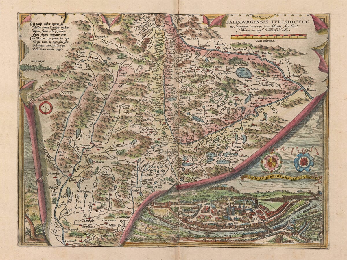
Abraham Ortelius published this map of Salzburg in his 1574 Latin edition of Theatrum Orbis Terrarum. The copperplate had first appeared in the inaugural 1570 edition and belongs to the earliest printed atlas designed as a consistent collection of maps.
Its Latin title, Salisburgensis Iurisdictionis, locorumque vicinorum vera descriptio, describes a true representation of the jurisdiction of Salzburg and its neighbouring places. The title names Marcus Secznagel of Salzburg as the cartographic source, making this an atlas engraving founded upon local geographical knowledge rather than a generalized view of Central Europe.
Map Details
- Original title: Salisburgensis Iurisdictionis, locorumque vicinorum vera descriptio
- Meaning: A true depiction of the jurisdiction of Salzburg and neighbouring places
- Inset title: Urbis Salisburgensis genuina descriptio
- Meaning: A true depiction of the city of Salzburg
- Atlas publisher: Abraham Ortelius
- Cartographic source: Marcus Secznagel of Salzburg
- City-view source: Based upon an earlier view associated with Sebastian Münster
- Plate first issued: Antwerp, 1570
- Edition represented: Theatrum Orbis Terrarum, 1574
- Approximate scale: 1:430,000
- Orientation: West is at the top
- Principal features: Salzburg, the Salzach, Hallein, Laufen, Berchtesgaden, Chiemsee, the Inn Valley and the surrounding Alps
- Format: Hand-coloured copperplate engraving
A Map Presented as a Curling Sheet
Ortelius’s engraving is immediately distinguished by its trompe-l’œil construction. The regional map is represented as a sheet of parchment fixed around its edges by small metal tacks. At the lower right, the parchment curls upwards to expose a panoramic view of Salzburg beneath it.
The folds, shadows and coloured underside of the imaginary sheet turn the map into a three-dimensional object. Mountain ranges and rivers appear to continue behind this theatrical foreground, while the city view occupies a separate pictorial space.
This design is more than decoration. It allows a geographical map and a recognizable portrait of Salzburg to share one copperplate without reducing either to a tiny conventional inset. Ortelius’s later replacement plate for the region omitted the city view, making this earlier composition particularly distinctive.
Salzburg and the River Salzach
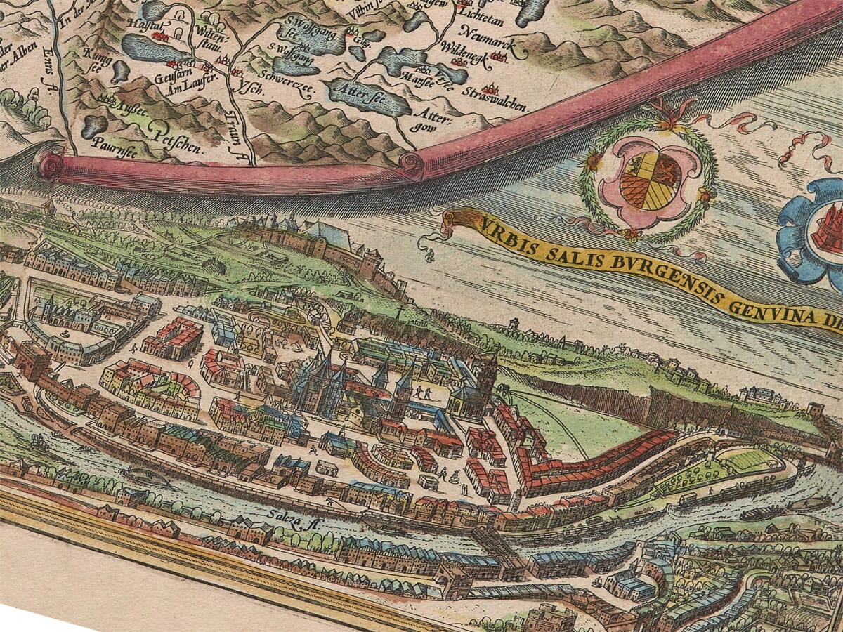
The bird’s-eye view shows Salzburg enclosed by walls and spread along the River Salzach. Streets, churches and substantial buildings are individually suggested, while the fortress of Hohensalzburg occupies the commanding hill above the city.
This is Salzburg before the great programme of Baroque rebuilding that transformed its appearance during the seventeenth and eighteenth centuries. The view therefore preserves a late Renaissance city whose towers, walls and river crossings still belonged principally to the medieval landscape.
Above the panorama appear two coats of arms and a ribbon carrying the city view’s Latin title. They visually connect the urban portrait with the ecclesiastical territory represented across the larger map.
The Archbishopric and Its Neighbours
The map does not depict the modern Austrian federal state. It records the jurisdiction associated with the Prince-Archbishopric of Salzburg, an ecclesiastical territory within the Holy Roman Empire.
Its boundaries thread through an Alpine landscape of valleys, lakes and mountain barriers. Berchtesgadener Land is prominently named to the east of Salzburg, while neighbouring Bavarian and Tyrolean country appears around the edges.
Hallein lies south of the city beside the Salzach, in the country historically associated with Salzburg’s valuable salt industry. Laufen appears farther downstream, while the mapped waters and settlements extend towards Chiemsee and the Inn Valley.
These territorial relationships make the 1574 date important. The engraving predates the modern Austrian state by centuries and presents Salzburg as the centre of an independent ecclesiastical principality.
Reading the Map Sideways
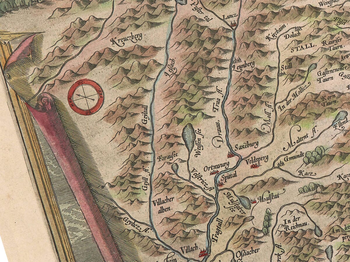
West is placed at the top of the engraving rather than north. The arrangement can initially make familiar places appear unexpectedly positioned, particularly because modern viewers instinctively expect north to occupy the upper edge.
The compass rose provides the necessary guide. Once the orientation is understood, the Salzach valley, Alpine passes and surrounding waterways become easier to follow.
This was not an error. Sixteenth-century atlas maps were frequently rotated to use the available copperplate efficiently and to accommodate the natural shape of the territory. Ortelius’s atlas contains numerous maps whose orientation differs from modern convention.
Mountains, Lakes and River Valleys
Mountain chains occupy much of the plate. They are represented by repeated pictorial peaks rather than measured contours, producing a densely folded landscape crossed by narrow valleys.
The Salzach forms the central geographical thread, linking Salzburg with Hallein and settlements farther along the valley. Chiemsee and numerous smaller lakes are strongly outlined, while the Inn and its tributaries place the archbishopric within the broader geography of Bavaria and Tyrol.
Red-roofed town symbols, wooded areas and individually named communities fill the spaces between the mountain ranges. The engraving consequently rewards close inspection: its principal places are surrounded by a dense record of smaller settlements, rivers and local names.
Marcus Secznagel’s Salzburg
The title cartouche explicitly credits Marcus Secznagel, a Salzburg cartographer active during the sixteenth century. An eight-line Latin poem in the upper-left corner praises him for bringing honour to his native country through his work and asks Salzburg to cherish his achievement.
Ortelius’s acknowledgement is significant. His atlas brought together geographical information obtained from mapmakers across Europe, redrawing their work into copperplates of a consistent size and style. Secznagel supplied the local foundation; Ortelius transformed it into a map that circulated internationally through successive atlas editions.
The result combines regional geography, civic portraiture and ingenious graphic design. More than four centuries later, it remains both a record of the old archbishopric and one of the most visually memorable early maps of Salzburg.





 Verified owner












