Joan Blaeu’s Seventeenth-Century Map of Stirlingshire
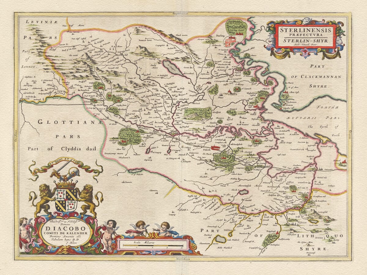
This magnificent early map of Stirlingshire was published in Amsterdam by Joan Blaeu in 1654 as part of the first great printed Atlas of Scotland. Entitled Sterlinensis praefectura. Sterlin-Shyr, the map directly credits Timothy Pont, whose survey of the eastern Central Lowlands during the late sixteenth century provided the geographical foundation for Blaeu’s engraved sheet. Institutional records describe Pont’s underlying work as covering Stirling, Falkirk and Kilsyth.
Map Details
Original title: Sterlinensis praefectura. Sterlin-Shyr. Auct. Timoth. Pont
Original cartographer / surveyor: Timothy Pont
Publisher: Joan Blaeu
First published: Amsterdam, 1654
Area shown: Historic Stirlingshire and adjoining parts of central Scotland, including Stirling, Falkirk and the country towards Kilsyth and the Firth of Forth
Principal features: Stirling and Stirling Castle, River Forth, historic bridge, rivers, mountains, forests, towns, villages, castles, abbeys and the line of the Antonine Wall
Decoration: Elaborate title and dedication cartouches, royal arms and cherubs decorating the scale of miles
Source atlas: Theatrum Orbis Terrarum, sive Atlas Novus, Volume V — Scotland, 1654
Product type: Reproduction of a seventeenth-century copper-engraved map
Timothy Pont’s survey belongs to one of the most ambitious early attempts to map Scotland region by region. During the closing years of the sixteenth century he travelled through the country recording rivers, settlements, estates, castles, churches and physical features. His manuscript maps were never published during his lifetime, but much of his work survived and ultimately provided the foundations for Blaeu’s Scottish atlas.
The Stirlingshire sheet demonstrates just how much information Pont had gathered. Stirling itself dominates the northern portion of the map, with the town shown beside the River Forth, its bridge clearly represented and Stirling Castle standing prominently above it within its surrounding park. Specialist descriptions of the original engraving identify both “Starling” and “Starling Castel” among its most conspicuous features.
The importance given to Stirling reflects its exceptional position in Scottish history. The castle stood above one of the principal crossing places of the Forth and controlled routes between the Lowlands and the north. For centuries the town served as a royal and governmental centre, giving the surrounding district a political and military significance far greater than its size alone might suggest.
Away from Stirling, Blaeu’s engraving records a remarkably varied landscape. Rivers wind between pictorial hills, extensive areas of woodland are carefully represented and numerous villages, castles, fortified houses and abbeys populate the county. The National Library of Scotland describes the sheet as depicting the country around the former royal burgh of Stirling, with Clackmannanshire visible to the north-east.
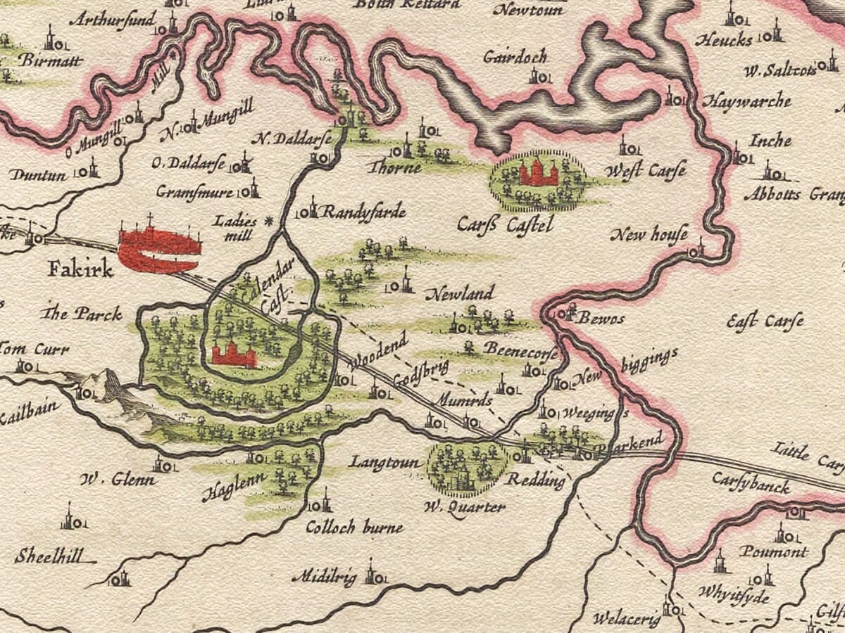
One of the map’s most historically important features is its representation of the Antonine Wall. Built by the Romans across central Scotland during the second century AD, the frontier ran between the Firth of Forth and the Clyde. Blaeu’s Stirlingshire map shows part of its course between Castlecary and Kinneil, making the sheet significant not only for seventeenth-century geography but also for the history of antiquarian attempts to understand Scotland’s Roman past. Modern research by the Society of Antiquaries of Scotland specifically reproduces this portion of Blaeu’s map and notes the extensive woodland shown around Cumbernauld and Callendar.
Pont’s original mapping of this area was undertaken in the 1590s, at a time when many of the remains of the Roman frontier were considerably more visible in the landscape than they are today. Later antiquaries relied upon these early maps when attempting to reconstruct the Wall’s route, giving the Stirlingshire sheet an importance extending far beyond its decorative appeal.
The settlements themselves provide another absorbing record of the county. Historic spellings frequently differ from those now familiar, while castles and substantial houses are given considerable prominence. Such features mattered greatly to Pont because late-sixteenth-century Scotland was organised around networks of estates, landowners, fortified residences and ecclesiastical centres.
Blaeu transformed this practical geographical material into a particularly handsome atlas plate. The sheet is richly decorated with title and dedication cartouches, while the scale is accompanied by the royal coat of arms and numerous cherubs. These elaborate additions exemplify the sophisticated engraving for which the Blaeu publishing house became internationally famous.
The resulting map therefore combines two quite different traditions. Pont supplied the detailed local geographical knowledge gathered in Scotland, while Blaeu’s Amsterdam workshop transformed that information into a prestigious European atlas sheet. Rivers, forests, castles and settlements could serve practical geographical purposes while ornate cartouches and heraldry made the finished map an object intended to impress.
When the Atlas of Scotland finally appeared in 1654, Pont had been dead for several decades. Yet his name was preserved prominently on the Stirlingshire map with the credit Auct. Timoth. Pont. The Royal Scottish Geographical Society’s collection likewise catalogues the 1654 sheet under Joan Blaeu while retaining Pont’s authorship in its complete title.
Today Sterlinensis praefectura offers a fascinating view of central Scotland before industrial development, modern roads, railways and systematic Ordnance Survey mapping transformed the region. Stirling Castle and the Forth remain instantly recognisable, while the forests, historic settlements, fortified houses and surviving line of the Roman Wall provide a remarkable window into an earlier landscape.
For anyone with connections to Stirling, Falkirk, Kilsyth or historic Stirlingshire, the map combines Timothy Pont’s pioneering survey work with the exceptional engraving and publishing craftsmanship of Joan Blaeu’s seventeenth-century Amsterdam workshop.
Browse our collection of old maps of Scotland →






 Verified owner
















