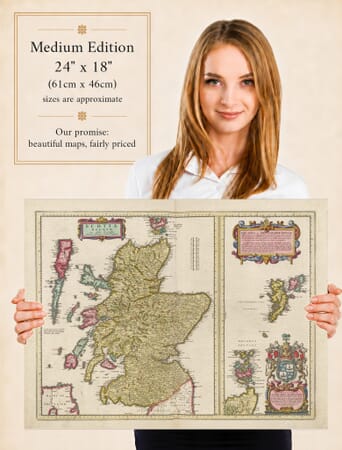
Old Map of Orkney and Shetland, Blaeu 1654
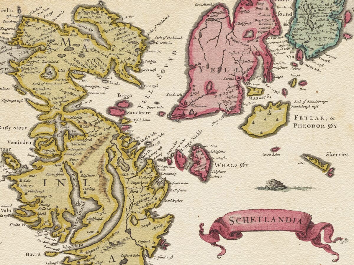
Old Map of Orkney and Shetland, Blaeu 1654 Orkney and The Shetland Islands Orkney and The Shetland Islands Detail

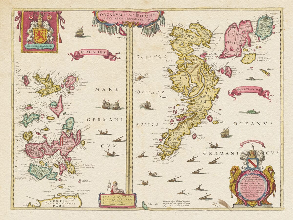
Old Map of Orkney and Shetland by Joan Blaeu, 1654

Price range: £35.55 through £59.95

Old map of Orkney and Shetland, prepared in the Blaeu workshop from the 1620s and published by Joan Blaeu in Amsterdam in 1654

Far beyond the northern coast of Scotland, Orkney and Shetland rise from seas that have shaped their history, livelihoods and sense of identity for centuries. Joan Blaeu’s magnificent old map presents the two archipelagos side by side, preserving their intricate coastlines and island communities as they were known in the seventeenth century.

Orkney occupies one half of the engraving, with its Mainland and surrounding islands gathered around sheltered sounds and natural harbours. Shetland fills the other, stretching northwards through a long chain of islands divided by narrow channels and open water. Historic place names, settlements and coastal features reward close exploration throughout both maps.

Sailing ships, marine creatures, heraldry and richly ornamented cartouches celebrate the islands’ enduring relationship with the sea. Reproduced as a finely detailed art print on subtly textured paper, this historic map makes an evocative reminder of Orkney, Shetland and the families and journeys connected with Scotland’s Northern Isles.
+ read more

A stunning certified FINE ART PRINT on heavy textured art paper — not a poster

  • Direct from the publisher — no middlemen
  • Printed in-house in Cornwall
  • Free UK delivery — international shipping available
  • Produced to meet — and often exceed — museum-quality standards

SELECT SIZE

Inspecting Vintage Map Reproduction

Fine Art Map Reproductions – Museum-Quality Printing

Unlike most online offerings, our maps are produced entirely in-house, not outsourced to print-on-demand or drop-shipping services. This allows complete control over quality while offering better value. Each map begins with a high-resolution original, carefully enhanced and printed to order using archival papers and pigment inks for exceptional clarity, depth, and longevity. Every piece is personally overseen — no map leaves our workshop unless it is of a quality we would be proud to display ourselves.

Hand hold a magnifying glass over West Cornwall Map

Authentic Old Map Paper & Accurate Colour Reproduction

Paper choice is essential to the authenticity of our maps. We use specially sourced 190gsm paper made in the UK from pure materials and traditionally pressed with natural woollen felts. This process creates a subtle, randomly textured surface that closely resembles an original antique document. Likewise the use of premium quality ink fully saturates the paper, producing remarkable clarity, depth, and historical character. Colour fastness and sharpness will remain good for in excess of 100 years!

Map in Postal Tube
Buy Old Maps Online in the UK Today Trading online since 1999

The Old Map Company of Great Britain offers a vast and carefully curated collection of the very finest expertly reproduced vintage maps. Our range includes works by renowned cartographers such as John Speed and Willem Blaeu, covering Scotland, England, and beyond. Free UK courier delivery is included, with EU, USA, and worldwide shipping available at cost and calculated at checkout. If you need assistance, our team is always happy to help you choose the perfect map.

RECENT REVIEWS

Daz
DazGB
Verified ownerVerified owner
5/5

Speedy delivery A beautiful representation

1 month ago
David H
David H
Verified ownerVerified owner
5/5

Got there in time and loves it! Cheers David [Gift from US to UK]

4 months ago
Ellan C-S
Ellan C-S
Verified ownerVerified owner
5/5

Thanks Lauren. We received it today - it's gorgeous! Thank you, Ellan

4 months ago
Ivano Di Battista
Ivano Di Battista
Verified ownerVerified owner
5/5

Thank you for your prompt service. I have a gallery and framing business in South Wales. I'm so pleased it is printed in the UK

4 months ago
Robert B
Robert B
Verified ownerVerified owner
5/5

My Isles of Scilly map arrived safely and I'm delighted with it!

4 months ago
Andrew T
Andrew T
Reviewer
5/5

The print arrived safely and we're delighted with it - a lovely reminder of our honeymoon 15 years ago.

5 months ago
Hannah J
Hannah J
Verified ownerVerified owner
5/5

I have just received them! I'm sure our clients will be pleased with them and there could be more projects off the back of this one where we can use more. [Interior Designers]

5 months ago
Sean MacManus
Sean MacManus
Verified ownerVerified owner
5/5

I just received my map of Ireland by Ewart today and, as usual, I am delighted by its quality. The crispness and fineness of detail is excellent and the colour reproduction surpasses my expectations. Please relay my thanks to Steve for another fine effort!

5 months ago
John G
John G
Verified ownerVerified owner
5/5

Many thanks, Lauren. Very pleased with the map and the service: would recommend The Old Map Company to anyone interested in Old Maps.

7 months ago
Lois K
Lois K
Verified ownerVerified owner
5/5

Thrilled , Lauren! Thank You

7 months ago
Ed Simpson
Ed Simpson
Verified ownerVerified owner
5/5

Many thanks, the map arrived safely this morning, and I’m really pleased with it. A stunning reproduction, just as I had hoped. I will keep browsing your website, and may yet be tempted by more of your items! Have a great weekend.

7 months ago
Daniel McCade
Daniel McCade
Verified ownerVerified owner
5/5

Just arrived, wonderful map! Thanks very much!

8 months ago
Jonathon R
Jonathon R
Verified ownerVerified owner
5/5

The map – beautiful – arrived safely, very many thanks.

1 year ago
Rasa Terbetiene
Rasa Terbetiene
Verified ownerVerified owner
5/5

Thank you, I have already found the map. It’s wonderfull! Good luck! Rasa

3 years ago
Mina M.
Mina M.
Verified ownerVerified owner
5/5

My apologies for the very late reply. I wanted to reach out to thank you so much for rushing my order. My partner absolutely loved it. I am amazed with the service so that is a five-star from me. I wish you all the best.

4 years ago

Blaeu’s Seventeenth-Century Map of Orkney and Shetland

This striking early map of Orkney and the Shetland Islands was published in Amsterdam in 1654 as part of Joan Blaeu’s great Atlas of Scotland. Entitled Orcadum et Schetlandiae Insularum accuratissima descriptio, it presents Scotland’s two great northern archipelagos side by side, combining detailed geographical information with the elaborate decoration for which the Blaeu workshop became celebrated. The sheet has an unusually long history: evidence discovered in the correspondence surrounding the atlas shows that it was already being prepared for Willem Blaeu during the 1620s, decades before its eventual publication by his son Joan.

Map Details

Original title: Orcadum et Schetlandiae Insularum accuratissima descriptio

Underlying cartographic source: Probably a now-lost map by Timothy Pont

Early preparation: Willem Blaeu; map in preparation by 1626 and engraved by 1628

Publisher of the 1654 atlas: Joan Blaeu

Published: Amsterdam, 1654

Area shown: The Orkney Islands and Shetland Islands, presented as two separate maps on a single engraved sheet

Decorative features: Sailing vessels, marine creatures, ornamental cartouches and heraldic decoration

Source atlas: Theatrum Orbis Terrarum, sive Atlas Novus, Pars Quinta — the Atlas of Scotland, 1654

Product type: Reproduction of a seventeenth-century copper-engraved map

The origins of this map are especially interesting because they reach back to the earliest attempts to create a detailed printed atlas of Scotland. Timothy Pont, who travelled extensively through Scotland during the late sixteenth and early seventeenth centuries, produced the first substantial body of regional mapping of the country. Many of his manuscript surveys survived and became the foundation of Blaeu’s Scottish atlas. The original Pont map for Orkney and Shetland has not survived, but National Library of Scotland research provides evidence that a lost Pont map was probably the source from which this engraving developed.

The sheet was apparently among the earliest Scottish maps to reach the Blaeu workshop. Correspondence demonstrates that it was being prepared by 1626 and had been engraved by 1628, during Willem Blaeu’s lifetime. Remarkably, however, it was not issued as part of the complete Scottish atlas until 1654, sixteen years after Willem’s death. His son Joan Blaeu ultimately brought the enormous project to publication in Amsterdam.

This history explains why attributing the map simply to either Willem or Joan Blaeu can be misleading. Willem was directly associated with its early preparation, while Joan was responsible for the atlas in which the map finally appeared. The 1654 Bibliothèque nationale de France example is catalogued under Joan Blaeu and records the map as an extract from the fifth part of his Theatrum Orbis Terrarum.

The map itself divides the sheet vertically. Orkney occupies the left-hand section, while Shetland fills the right, allowing both archipelagos to be represented at a useful scale despite the considerable distance separating them. The numerous islands, sounds and deeply indented coastlines immediately demonstrate why accurate mapping of Scotland’s Northern Isles presented such a formidable challenge to early surveyors.

For seventeenth-century inhabitants, the surrounding sea was not simply an empty space between islands. It was the principal highway connecting communities, transporting goods and linking Orkney and Shetland with mainland Scotland, Scandinavia and the wider North Atlantic world. Blaeu’s numerous engraved sailing vessels are therefore particularly appropriate decoration for this maritime landscape.

The sheet also contains the marine creatures characteristic of decorative early maps. Such figures should not be understood as part of the geographical survey itself. They belonged to the visual vocabulary of Renaissance and seventeenth-century cartography, enlivening areas of open water while contributing to the sense of distance and maritime adventure associated with the northern seas.

Orkney and Shetland had distinctive historical identities long before Blaeu’s map appeared. Both archipelagos had deep Norse connections and remained under Norwegian and Danish rule until the fifteenth century. Orkney and Shetland were pledged to the Scottish Crown in 1468 and 1469 respectively as security connected with the marriage of James III of Scotland to Margaret of Denmark. Their Scandinavian inheritance continued to influence language, place-names, law and culture long afterwards.

Many of those layers of history are visible indirectly through the names recorded on an early map such as this. Spellings differ markedly from modern forms, reflecting a world in which geographical names were still being transferred from local speech and manuscript records into printed European cartography.

The publication of Blaeu’s Atlas of Scotland in 1654 was a landmark. For the first time, detailed maps covering much of Scotland were brought together within a major printed atlas. The project preserved information collected decades earlier and transformed it through the extraordinary engraving and printing standards of Amsterdam’s foremost cartographic workshop. The University of Edinburgh’s historical map collection records this Orkney and Shetland sheet as a 1654 work published under Joan Blaeu.

Today the map is valuable both as a decorative work and as a record of how the Northern Isles were understood more than three and a half centuries ago. Its unusual two-part composition, historic place-names, sailing vessels, marine decoration and complex Blaeu publishing history make it one of the most distinctive maps in the Scottish atlas.

For anyone with a connection to Orkney or Shetland, it provides a fascinating link with an island landscape whose relationship with the sea has shaped its history for centuries.

Browse our collection of old maps of Scotland.

You may also like…

×
Product added to cart
No products in the cart.