The Western Isles in Joan Blaeu’s Atlas of Scotland
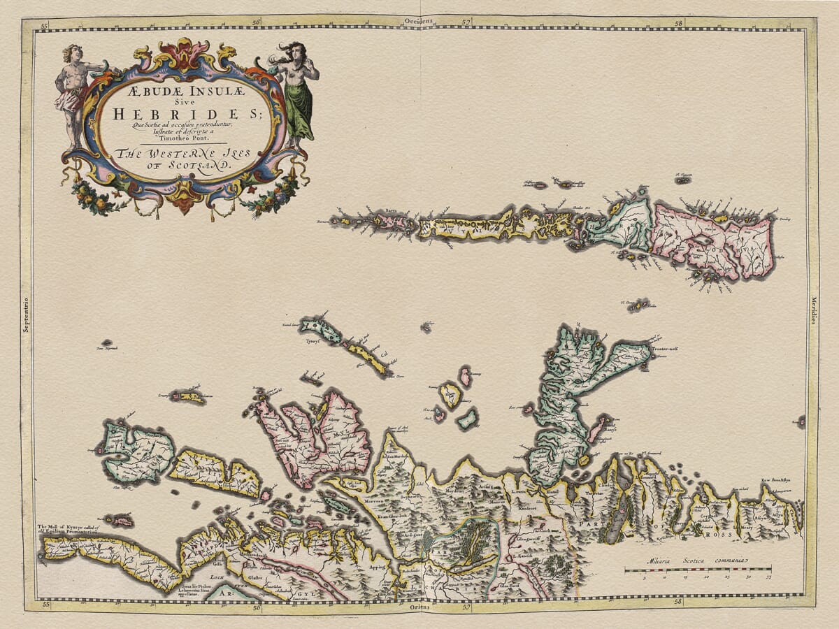
This remarkable seventeenth-century map of the Hebrides was published in Amsterdam by Joan Blaeu in 1654. Its original Latin title, Æbudæ Insulæ sive Hebrides, quæ Scotiæ ad occasum prætenduntur, is accompanied by the English title The Westerne Iles of Scotland. Importantly, the map itself acknowledges the work of the pioneering Scottish cartographer Timothy Pont, whose surveys provided the geographical foundation for many of the maps in Blaeu’s great atlas of Scotland. Contemporary catalogue records identify both Blaeu and Pont and date this particular map firmly to 1654.
Pont was one of the most important figures in the early mapping of Scotland. During the closing decades of the sixteenth century he travelled extensively through the country, making detailed manuscript surveys of landscapes, settlements, rivers, islands and estates. The surviving Pont manuscripts date broadly from the period c.1583–1596, and the National Library of Scotland regards them as the first detailed mapping of large areas of the country.
Pont never succeeded in publishing the great Scottish atlas he appears to have envisaged. Following his death, however, his manuscript material was preserved and eventually reached the Dutch publishing house of the Blaeu family. With the assistance of Scottish scholars and patrons, Pont’s surveys were prepared for engraving and became the basis for a substantial proportion of the maps appearing in Joan Blaeu’s Scottish atlas.
Published in 1654 as part of Blaeu’s Theatrum Orbis Terrarum sive Atlas Novus, the Scottish volume represented a landmark in British cartography. The National Library of Scotland describes the 1654 work as the first atlas of Scotland, providing an exceptional record of the country in the seventeenth century. The NLS collection today includes 47 individual Blaeu map sheets from 1654, alongside Pont’s surviving manuscript maps.
The Hebrides map is particularly distinctive because it is oriented with west at the top. To modern eyes this makes the geography initially appear unfamiliar, but orientation varied considerably on early maps and was often chosen to make the most effective use of the engraved sheet. With the Western Isles extending prominently across the composition, Blaeu was able to present the scattered island geography on an impressive scale. An elaborate title cartouche, figures and a scale expressed in common Scottish miles add the decorative qualities characteristic of the Blaeu publishing house.
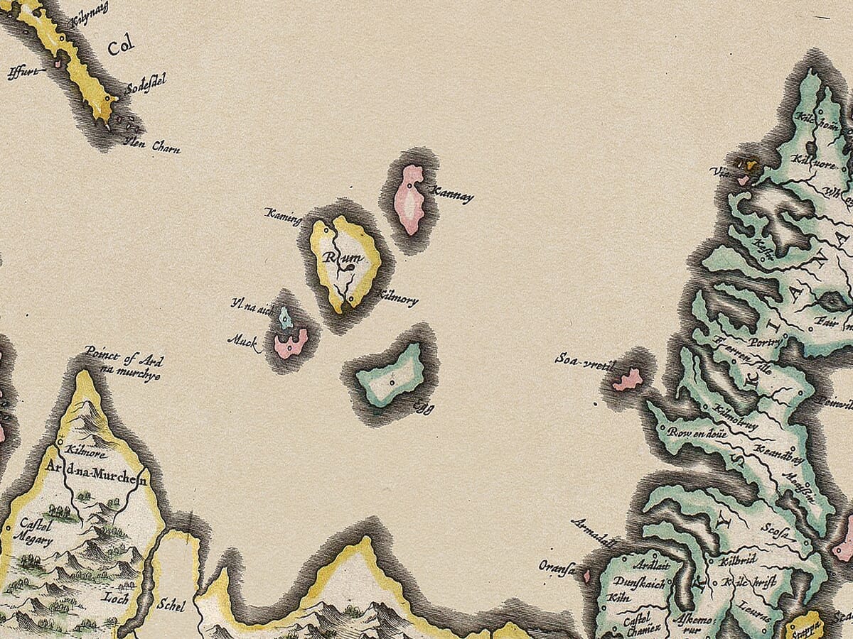
The map is fascinating not simply as an attractive piece of seventeenth-century engraving but also as a record of how the Hebrides were understood before modern surveying. Coastlines, settlements and numerous historic place-names preserve a geographical picture whose origins reach back to Pont’s observations many decades before the map finally appeared in print. Modern roads, accurate triangulation and the systematic Ordnance Survey still lay far in the future.
This long delay between the original Scottish fieldwork and the publication of the engraved map makes Blaeu’s Hebrides especially interesting. Although dated 1654, much of the geographical intelligence behind it belongs to the late sixteenth and early seventeenth centuries. It therefore preserves an unusually early view of Scotland’s western islands while presenting that information through the sophisticated engraving and publishing techniques of Amsterdam’s great seventeenth-century cartographic industry.
Blaeu’s atlas also marked an important transition in the history of Scottish mapmaking. Pont’s practical manuscript surveys were transformed into beautifully engraved maps intended for an international audience. Hills, waterways, settlements, islands and coastal forms were combined with decorative cartouches and carefully engraved lettering, turning geographical information into objects that were as visually impressive as they were informative.
For anyone with family connections to the Hebrides or Western Isles, the abundance of early place-names makes the map particularly rewarding to explore. For the historian, it represents an important stage in the development of Scottish cartography. And as an example of the work of Joan Blaeu and Timothy Pont together, it forms part of one of the most significant achievements in the early mapping of Scotland.






 Verified owner















