Exploring Blaeu’s Old Map of Nithsdale
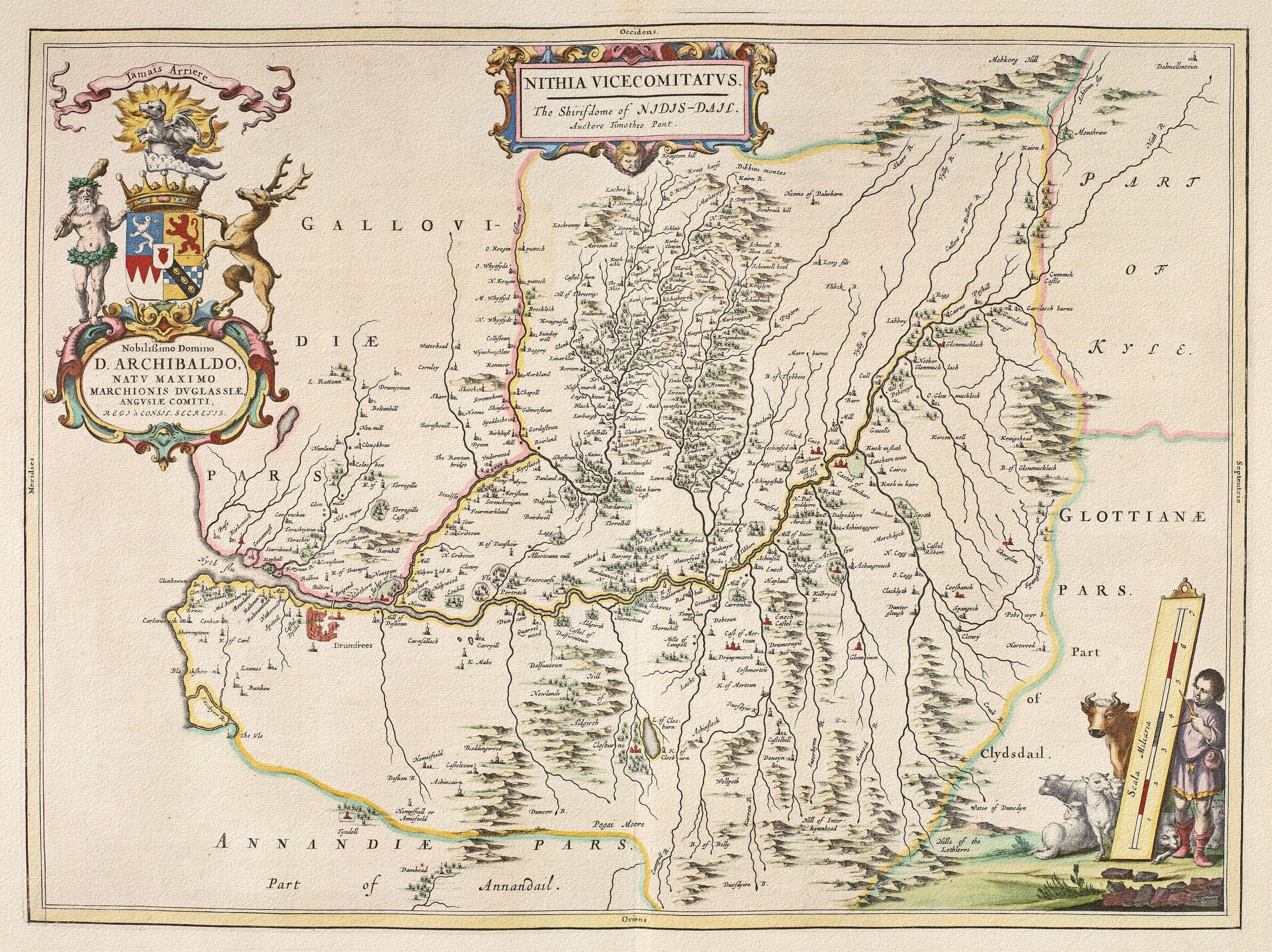
Joan Blaeu’s map of Nithsdale was published in Amsterdam in 1654 as part of his celebrated Atlas of Scotland. Its engraved title, Nithia Vicecomitatus. The Shirifdome of Nidis-Dail, identifies the region in Latin and in an early Scots form of “the Sheriffdom of Nithsdale.”
- Original title: Nithia Vicecomitatus. The Shirifdome of Nidis-Dail
- Region depicted: Nithsdale and the complete River Nith watershed
- Publisher: Joan Blaeu
- First published: Amsterdam, 1654
- Source mapping: The engraved map was prepared from an earlier Scottish manuscript survey
- Orientation: West is at the top
- Northern extent: Upland country around Dalmellington
- Southern extent: Dumfries and the Solway Firth
- Principal places: Dumfries, Sanquhar, Kirkconnel and New Cumnock
- Notable waterways: River Nith, Shinnel Water and River Cairn
- Notable feature: The bridge over the River Nith at Dumfries
- Source atlas: Joan Blaeu’s Atlas of Scotland
- Product type: Fine art reproduction print of the historic map
The map follows the complete watershed of the River Nith, from the upland country around Dalmellington to Dumfries and the Solway Firth. Rivers, burns and valleys form a natural framework for hundreds of towns, villages, estates, castles and smaller rural settlements.
One of its most unusual features is its orientation: west is placed at the top rather than north. Modern viewers may therefore need a moment to recognise the landscape, but this unconventional arrangement allows the long course of the River Nith to spread naturally across the sheet.
Following the River Nith
The River Nith is the defining feature of the engraving. It rises among the hills of southern Ayrshire and flows through New Cumnock, Kirkconnel and Sanquhar before entering the broader valley that leads towards Dumfries.
Rather than appearing as a single isolated line, the river is joined by a complex network of tributaries. These waterways connect upland glens with the more closely settled country farther south and reveal how thoroughly the landscape was shaped by its drainage system.
The Shinnel Water and River Cairn are particularly rich in recorded settlements. Farms, towers, estates and small communities cluster along their banks, creating an unusually detailed picture of rural occupation. Many names can still be recognised, while others survive only in local farms, roads or fragments of the modern landscape.
The mountains surrounding the valley are drawn as overlapping pictorial hills. They are not scientifically measured contours, but their density conveys the enclosure of Nithsdale by high country and the importance of the river as a natural route through it.
Sanquhar and Upper Nithsdale
Sanquhar appears in the upper valley, where routes through the Southern Uplands converged beside the River Nith. Its castle, burgh and surrounding estates gave it considerable importance despite its relatively remote position.
The historic landscape around Sanquhar was shaped by upland farming, mineral resources and the movement of people between Dumfriesshire, Ayrshire and Clydesdale. Blaeu’s map predates the later development of coal mining and modern transport, presenting the upper dale as a dispersed collection of settlements linked principally by rivers and valleys.
Farther down the Nith, the country becomes more densely mapped. Estates and fortified houses appear throughout the valley, reflecting a region where landownership, family alliances and defensive architecture had long influenced settlement.
Dumfries and the Solway Firth
Dumfries occupies a prominent position near the lower River Nith. It was already an important royal burgh, market town and crossing place, closely connected with the surrounding countryside and the routes leading towards Galloway, Annandale and northern England.
The map distinctly records the bridge crossing the River Nith at Dumfries. This small but significant detail illustrates the town’s importance as a meeting point for travellers, livestock, trade and local administration.
Below Dumfries, the river widens as it approaches the Solway Firth. Marshes, tidal waters and low-lying ground distinguish this southern end of the dale from the enclosed uplands farther north. The Solway connected the region with coastal trade and fishing, while also forming a broad natural frontier between Scotland and England.
Blaeu’s coastline and river mouth should not be interpreted as a precise modern hydrographic survey. Channels and shorelines around the Solway were constantly affected by tides, silting and shifting sands. Nevertheless, the engraving captures the relationship between Dumfries, the River Nith and the open firth beyond.
A Historic Province of Southern Scotland
Nithsdale, also known historically as Strathnith or Strath Nith, was one of the medieval provinces of Scotland. It later formed part of Dumfriesshire, but the older regional name continued to describe the valley and the communities gathered around the river.
Its position near the western Borders gave Nithsdale a history shaped by competing families, fortified houses and periods of conflict between Scotland and England. By 1654, however, the map’s principal interest was geographical rather than military. Castles and towers appear as part of the settled landscape rather than as a record of a particular campaign.
The map is exceptionally valuable for its concentration of rural names. It preserves a countryside before turnpike roads, railways and modern town expansion altered the pattern of communication through the dale.
Some modern expectations must be set aside when reading it. Roads are not recorded systematically, hills are symbolic and the relative size of a settlement does not provide a reliable measure of its population. Criffel, one of the most recognisable hills near the Solway coast, was notably omitted by the engravers.
Cartouches, Heraldry and Rural Life
The geographical detail is accompanied by some of the most memorable decoration in Blaeu’s Scottish atlas. The title is enclosed within an ornamental cartouche, while a separate heraldic dedication honours Archibald Douglas, Marquess of Douglas.
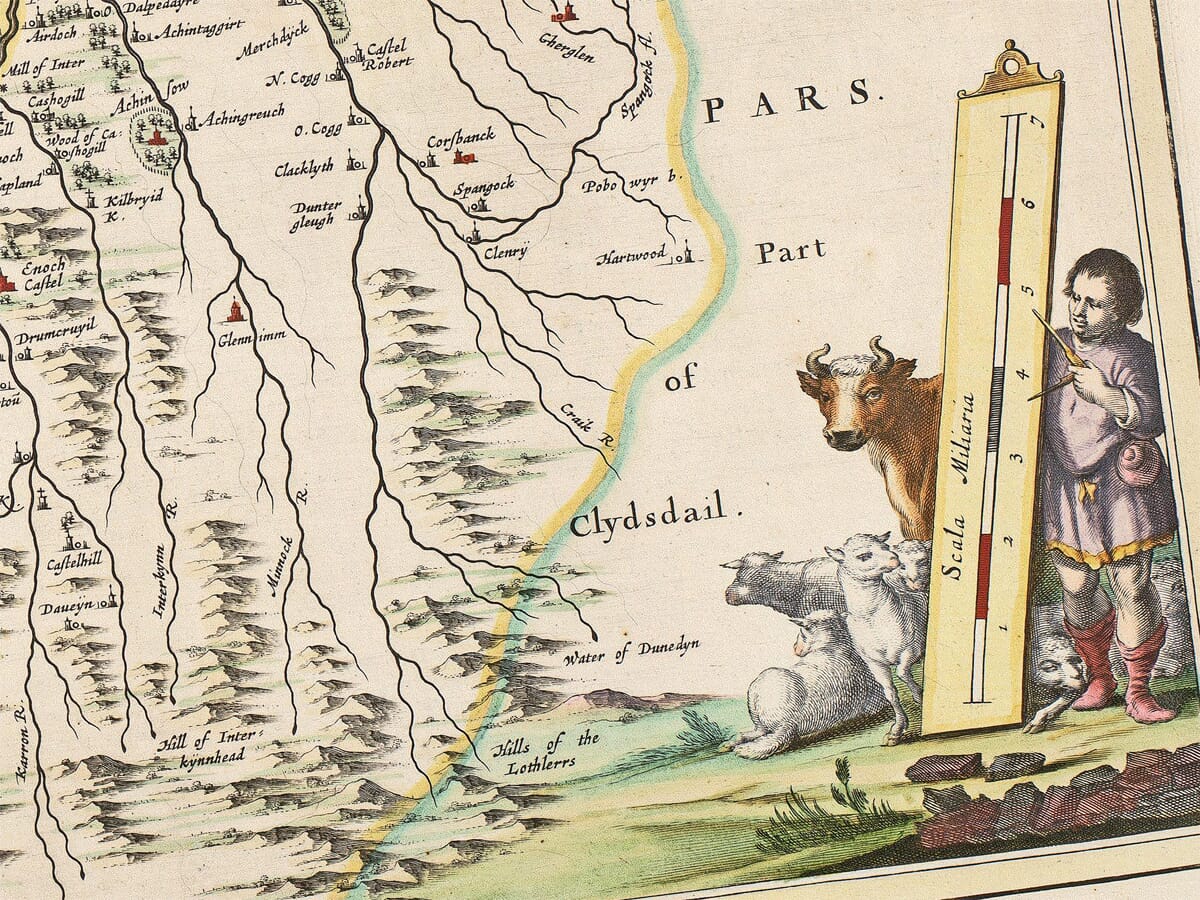
The arms are accompanied by striking supporters, including a stag and a giant figure. Elsewhere, the scale of miles is incorporated into a decorative scene with a human figure and animals. These elements bring a sense of life and ceremony to the densely mapped countryside.
They also balance the composition. The open areas surrounding the title, dedication and scale provide visual relief from the intricate pattern of rivers, hills and settlements.
Today this old map allows the eye to follow the Nith from remote uplands to Dumfries and the broad waters of the Solway. For anyone with family roots or affection for Dumfries and Galloway, it offers an evocative connection with a landscape whose river, communities and old place names have endured for centuries.






 Verified owner
















