greek islands
greek islands Mediterranean Islands Map greek islands detail Mediterranean Islands Map

Mediterranean Islands Map – British Possessions, 1851

Price range: £35.55 through £59.95

Mediterranean Islands Map

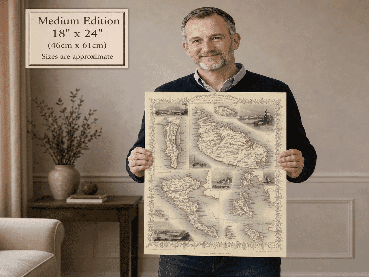
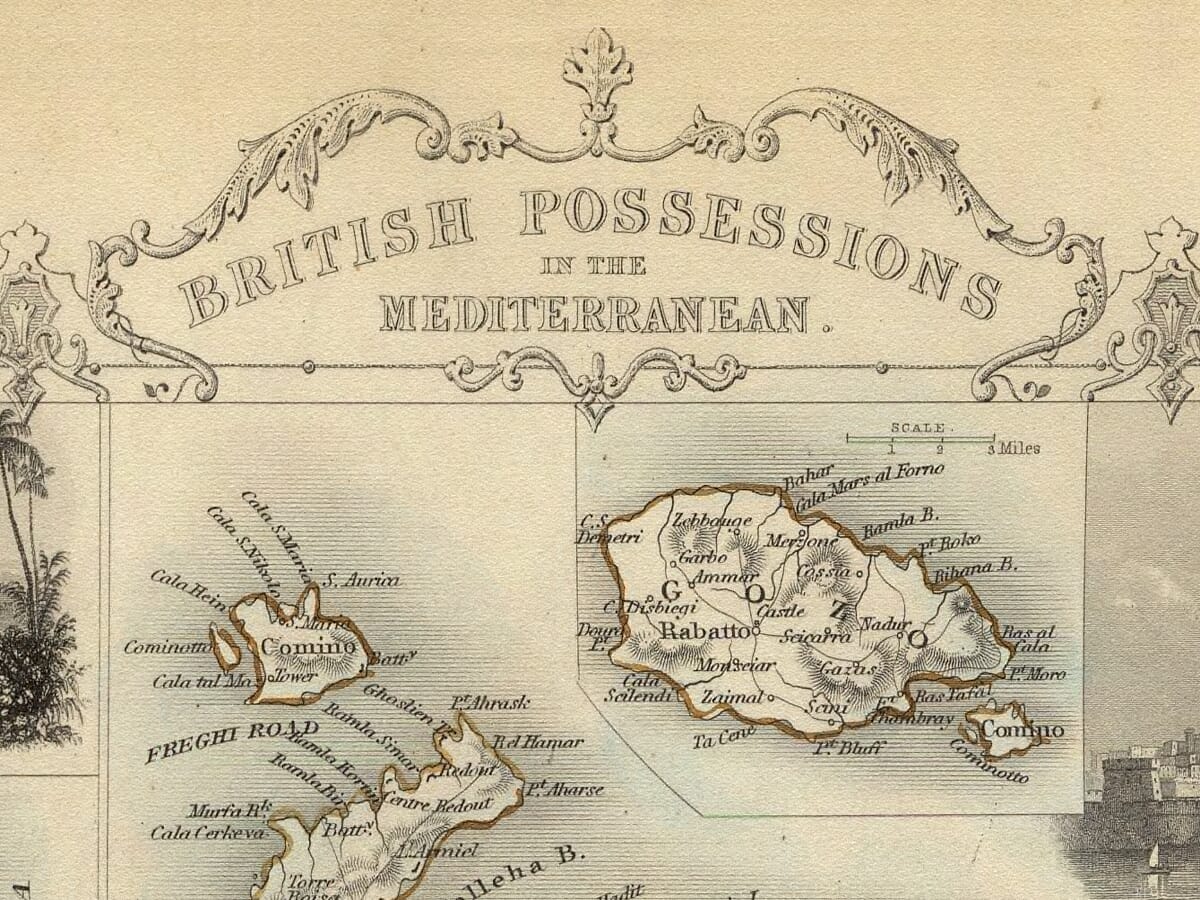
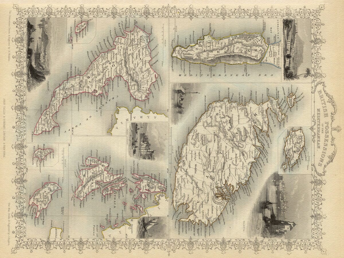
This richly decorative Mediterranean Islands Map was drawn and engraved by John Rapkin for John Tallis’s celebrated Illustrated Atlas in 1851. Originally titled British Possessions in the Mediterranean, it brings together separate maps of Gibraltar, Malta and Gozo, Corfu and the Ionian Islands in one beautifully balanced Victorian composition.

Fine engraved detail reveals harbours, coastal settlements, roads, forts and anchorages, while H. Winkles’s surrounding illustrations depict ports, vessels and Mediterranean scenery. Delicate colour and an ornamental border give the sheet the distinctive visual appeal for which Tallis maps are admired.

It makes a particularly meaningful print for anyone with connections to Malta, Gibraltar, Corfu, Paxos, Zante, Cephalonia, Ithaca or the wider Mediterranean. Equally at home in a study, living room or coastal interior, it offers both an absorbing record of nineteenth-century geography and a handsome decorative statement.
+ read more

A stunning certified FINE ART PRINT on heavy textured art paper — not a poster

  • Direct from the publisher — no middlemen
  • Printed in-house in Cornwall
  • Free UK delivery — international shipping available
  • Produced to meet — and often exceed — museum-quality standards

SELECT SIZE

Inspecting Vintage Map Reproduction

Fine Art Map Reproductions – Museum-Quality Printing

Unlike most online offerings, our maps are produced entirely in-house, not outsourced to print-on-demand or drop-shipping services. This allows complete control over quality while offering better value. Each map begins with a high-resolution original, carefully enhanced and printed to order using archival papers and pigment inks for exceptional clarity, depth, and longevity. Every piece is personally overseen — no map leaves our workshop unless it is of a quality we would be proud to display ourselves.

Hand hold a magnifying glass over West Cornwall Map

Authentic Old Map Paper & Accurate Colour Reproduction

Paper choice is essential to the authenticity of our maps. We use specially sourced 190gsm paper made in the UK from pure materials and traditionally pressed with natural woollen felts. This process creates a subtle, randomly textured surface that closely resembles an original antique document. Likewise the use of premium quality ink fully saturates the paper, producing remarkable clarity, depth, and historical character. Colour fastness and sharpness will remain good for in excess of 100 years!

Map in Postal Tube
Buy Old Maps Online in the UK Today Trading online since 1999

The Old Map Company of Great Britain offers a vast and carefully curated collection of the very finest expertly reproduced vintage maps. Our range includes works by renowned cartographers such as John Speed and Willem Blaeu, covering Scotland, England, and beyond. Free UK courier delivery is included, with EU, USA, and worldwide shipping available at cost and calculated at checkout. If you need assistance, our team is always happy to help you choose the perfect map.

RECENT REVIEWS

Daz
DazGB
Verified ownerVerified owner
5/5

Speedy delivery A beautiful representation

1 month ago
David H
David H
Verified ownerVerified owner
5/5

Got there in time and loves it! Cheers David [Gift from US to UK]

3 months ago
Ellan C-S
Ellan C-S
Verified ownerVerified owner
5/5

Thanks Lauren. We received it today - it's gorgeous! Thank you, Ellan

3 months ago
Ivano Di Battista
Ivano Di Battista
Verified ownerVerified owner
5/5

Thank you for your prompt service. I have a gallery and framing business in South Wales. I'm so pleased it is printed in the UK

4 months ago
Robert B
Robert B
Verified ownerVerified owner
5/5

My Isles of Scilly map arrived safely and I'm delighted with it!

4 months ago
Andrew T
Andrew T
Reviewer
5/5

The print arrived safely and we're delighted with it - a lovely reminder of our honeymoon 15 years ago.

4 months ago
Hannah J
Hannah J
Verified ownerVerified owner
5/5

I have just received them! I'm sure our clients will be pleased with them and there could be more projects off the back of this one where we can use more. [Interior Designers]

4 months ago
Sean MacManus
Sean MacManus
Verified ownerVerified owner
5/5

I just received my map of Ireland by Ewart today and, as usual, I am delighted by its quality. The crispness and fineness of detail is excellent and the colour reproduction surpasses my expectations. Please relay my thanks to Steve for another fine effort!

5 months ago
John G
John G
Verified ownerVerified owner
5/5

Many thanks, Lauren. Very pleased with the map and the service: would recommend The Old Map Company to anyone interested in Old Maps.

6 months ago
Lois K
Lois K
Verified ownerVerified owner
5/5

Thrilled , Lauren! Thank You

7 months ago
Ed Simpson
Ed Simpson
Verified ownerVerified owner
5/5

Many thanks, the map arrived safely this morning, and I’m really pleased with it. A stunning reproduction, just as I had hoped. I will keep browsing your website, and may yet be tempted by more of your items! Have a great weekend.

7 months ago
Daniel McCade
Daniel McCade
Verified ownerVerified owner
5/5

Just arrived, wonderful map! Thanks very much!

8 months ago
Jonathon R
Jonathon R
Verified ownerVerified owner
5/5

The map – beautiful – arrived safely, very many thanks.

1 year ago
Rasa Terbetiene
Rasa Terbetiene
Verified ownerVerified owner
5/5

Thank you, I have already found the map. It’s wonderfull! Good luck! Rasa

3 years ago
Mina M.
Mina M.
Verified ownerVerified owner
5/5

My apologies for the very late reply. I wanted to reach out to thank you so much for rushing my order. My partner absolutely loved it. I am amazed with the service so that is a five-star from me. I wish you all the best.

4 years ago

British Possessions in the Mediterranean: A Victorian Map of Empire and Sea Power

Published in 1851, this remarkable map originally appeared in The Illustrated Atlas, and Modern History of the World, Geographical, Political, Commercial and Statistical. The atlas was edited by R. Montgomery Martin and published in London and New York by John and Frederick Tallis. Its maps combined detailed geography with decorative engraving, making them as attractive to display as they were informative to study.

The cartography was drawn and engraved by John Rapkin, whose work appeared throughout the Tallis atlas. The accompanying illustrations were drawn and engraved by H. Winkles. Together, they created a richly composed sheet in which maps, coastal views, ships and ornamental flourishes form a unified picture of Britain’s nineteenth-century Mediterranean presence.

Rather than presenting the Mediterranean as one continuous chart, Rapkin arranged a series of separate maps at different scales. These include Gibraltar, Malta and Gozo, and the British-protected Ionian Islands. Corfu, Paxos, Cerigo, Zante, Cephalonia, Ithaca and Santa Maura are all represented—the latter islands now being more commonly known as Kythira, Zakynthos, Kefalonia and Lefkada.

At the western entrance to the Mediterranean stands Gibraltar. Anglo-Dutch forces captured the peninsula in 1704 during the War of the Spanish Succession, and Spain ceded it to Great Britain under the Treaty of Utrecht in 1713. Its position beside the narrow strait connecting the Atlantic and Mediterranean gave Gibraltar exceptional naval and commercial importance. The Rock, harbour, fortifications and surrounding waters consequently occupy a prominent place within this composition.

Malta and Gozo formed Britain’s principal base in the central Mediterranean. Following a brief French occupation, Malta passed under British rule in 1800 and became a Crown Colony during the Napoleonic period. Its deep natural harbours and central position made it invaluable to the Royal Navy and to ships travelling between western Europe, the eastern Mediterranean and routes leading towards India. Rapkin’s detailed treatment of the Maltese islands reflects their importance as both a fortified outpost and a busy maritime crossroads.

The eastern part of the sheet records the United States of the Ionian Islands, a self-governing state placed under British protection in 1815. Corfu served as its administrative centre, while the other principal islands stretched southwards along the western coast of Greece. British administration brought new roads, public buildings and defensive works, but it also met considerable local opposition. Demands for union with Greece grew during the nineteenth century, and the protectorate was eventually relinquished in 1864, thirteen years after this map was published.

The map’s title, British Possessions in the Mediterranean, therefore reflects the political language and imperial outlook of its period. Gibraltar and Malta were governed directly by Britain, while the Ionian Islands occupied the more complicated position of a protected state. Rapkin’s composition brings these geographically separated territories together, visually presenting them as parts of a connected British maritime system.

Fine lettering identifies towns, harbours, bays, roads and coastal features, while outline colour distinguishes the different territories. The surrounding views of ports and vessels reinforce the maritime character of the subject. These illustrations also gave Victorian atlas owners an impression of distant places at a time when international travel remained beyond the reach of most people.

Viewed today, the map is both an attractive example of Victorian decorative cartography and a revealing historical document. It records a Mediterranean shaped by naval power, trade and competing empires, while preserving earlier spellings and names that have since changed. For those with family, travel or historical connections to Gibraltar, Malta, Gozo, Corfu or the Ionian Islands, it offers an especially engaging link with the region’s nineteenth-century past.

You may also like…

  • Detail from Old Map MaltaOld Map MaltaAdd to Basket This product has multiple variants. The options may be chosen on the product page

    Malta

    Price range: £35.55 through £59.95
  • Detail from an old map of CorfuOld Corfu MapAdd to Basket This product has multiple variants. The options may be chosen on the product page

    Corfu – Greece

    Price range: £35.55 through £59.95
  • Mediterranean Sanson DetailMeditteranean MapAdd to Basket This product has multiple variants. The options may be chosen on the product page

    Mediterranean by Sanson

    Price range: £35.55 through £59.95
  • Detail from Antique Map GibraltarReproduction Antique Map GibraltarAdd to Basket This product has multiple variants. The options may be chosen on the product page

    Gibraltar

    Price range: £35.55 through £59.95
×
Product added to cart
No products in the cart.