Historical Background
Johann Baptist Homann’s map of Malta and Gozo combines three ways of looking at the islands: an archipelago map, a detailed plan of the fortified harbour district and a panorama of Valletta from the water. Produced in Nuremberg in the early eighteenth century, it presents Malta as the principal seat of the Order of St John. The crowded decoration is part of that message, surrounding the geography with religious imagery, military equipment and maritime activity.
Map Details
- Original title: Insularum Maltae et Gozae quae sunt Equitum S. Ioannis Hierosolimitani Ordinis Melit. Sedes Principalis
- Mapmaker, engraver and publisher: Johann Baptist Homann
- Publication place: Nuremberg
- Period: Early eighteenth century; exact atlas issue unconfirmed
- Area shown: Malta, Gozo, Comino and nearby islands
- Orientation: North at the top of the principal island map
- Additional views: Harbour and fortification plan, with a waterfront panorama of Valletta
- Format: Engraved atlas map, with colour applied separately to the original impression
Three Views on One Sheet
The principal map places Gozo at the upper left, Comino between the larger islands, and Malta across the centre and right. Their outlines are surrounded by coloured coastal bands. Bays and narrow inlets interrupt the shore, while pictorial hills and clusters of trees distinguish the interior.
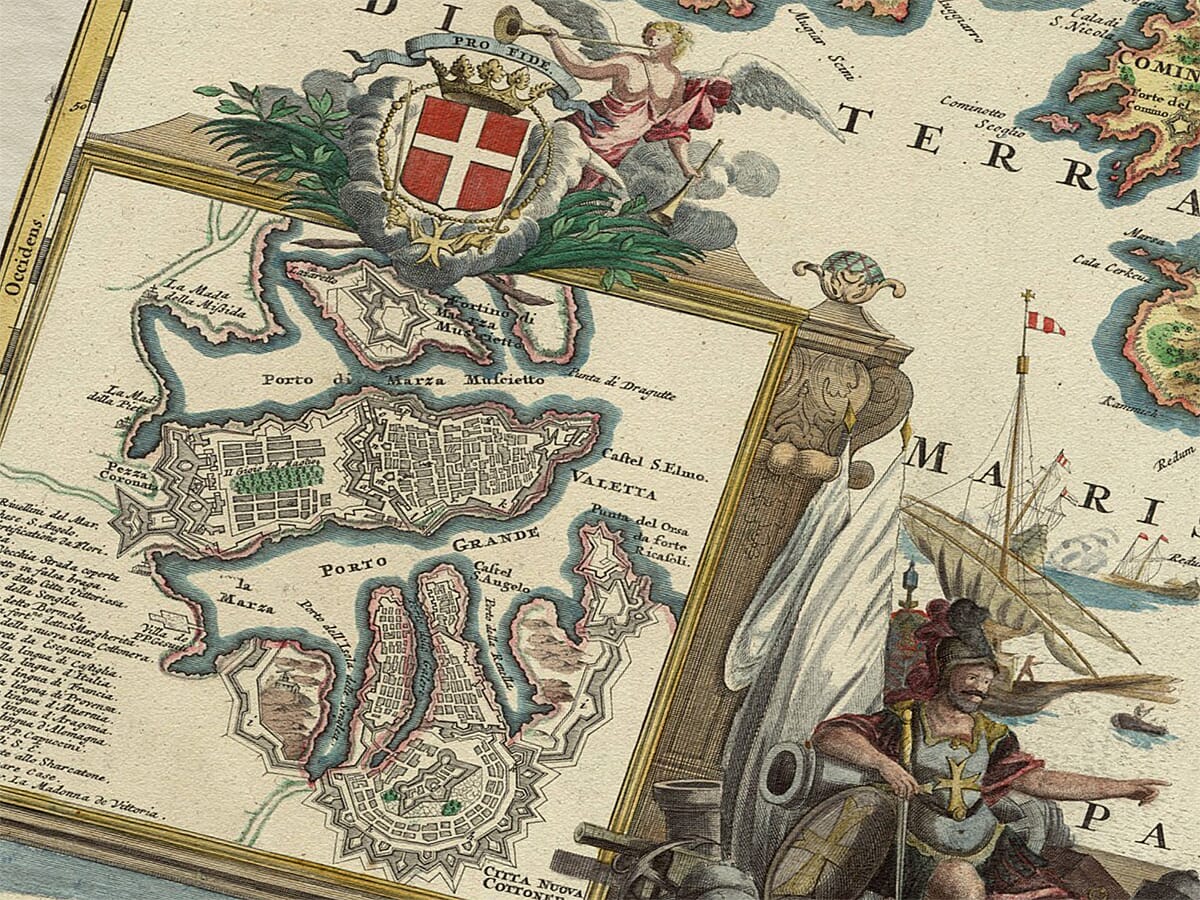
Below Gozo, a framed plan enlarges the harbour district. Underneath that, a long waterfront view changes the scale again, showing fortified walls, buildings and ships from a lower viewpoint. The composition lets the viewer move from the whole archipelago to its defensive centre, then imagine approaching that centre by sea.
Gozo, Comino and the Inland Capital
Gozo is labelled Gozo Insula, with its central fortified settlement identified as Castello and Borgo. Comino appears as a much smaller island in the channel. These different proportions make the relationship between the islands particularly easy to follow.
On Malta, the inland settlement is marked Civita Vecchia, the old city now known as Mdina, with Borgo nearby. Its prominent fortified outline provides a useful contrast with the coastal harbour complex. Around it, the map records a network of smaller settlements, many carrying the word Casal. Familiar places appear through historic spellings rather than the naming conventions of a modern tourist map.
Valletta and the Two Harbours
The inset shows Valletta occupying its narrow peninsula between harbour waters. A regular street pattern fills the fortified city, while bastions and enclosing walls give its perimeter a distinctive angular form. Across the Grand Harbour, other defended peninsulas and settlements demonstrate that this was a connected system of positions rather than a single isolated fortress.
Valletta was founded in 1566, following the Great Siege of 1565. Its planned streets and defences explain the unusually ordered appearance visible in the inset. Geography and engineering worked together: the peninsula provided a commanding position, and the harbour shores required protection from several directions.
The University of Malta identifies Homann’s fortification plan as derived from Vincenzo Maria Coronelli’s map of 1686. That source helps explain why an eighteenth-century atlas engraving contains a defensive landscape rooted in earlier mapping. A publication date does not necessarily mean every feature was surveyed afresh.
The Knights in the Decoration
The upper-right cartouche explicitly connects Malta with the Order of St John. A red banner bearing a white cross rises among the figures, while rays of light and heavenly forms give the scene a religious character. The map’s title describes the islands as the Order’s principal seat, so this imagery reinforces words already present in the engraving.
Elsewhere, heraldry appears above the harbour plan. Beside it, cannon, projectiles and other military equipment form an elaborate decorative group. These objects should be read as part of the map’s presentation of fortified Malta, rather than evidence of a particular battle taking place on the sheet.
Approaching Malta by Sea
The panorama at the bottom makes the sea approach tangible. Ships and smaller craft occupy the foreground, with the city’s walls and skyline stretching behind them. It complements the overhead plan by showing the visual effect of those defences from harbour level.
The resulting print invites several kinds of study: following old settlement names, comparing the two capitals, tracing the harbour fortifications or examining Homann’s elaborate engraving. Its interest lies in those connections between island geography, urban planning and the way Malta’s rulers wished their stronghold to be seen.




 Verified owner