Historical Background
Joan Blaeu’s Seventeenth-Century Map of the Isle of Arran
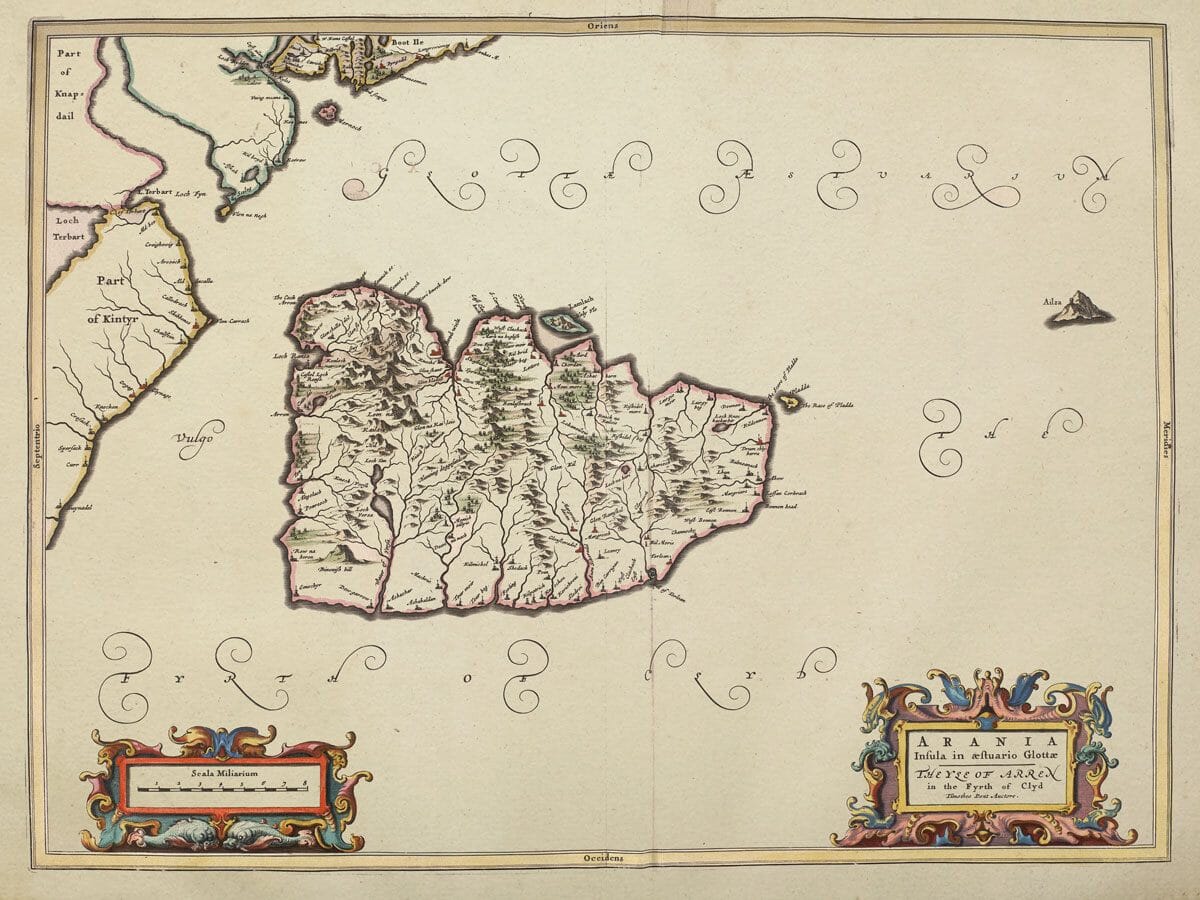
This beautifully engraved map of the Isle of Arran was published by Joan Blaeu in Amsterdam in 1654 as part of the celebrated fifth volume of his Atlas Novus, the volume devoted to Scotland. Its formal title, Arania Insula in aestuario Glottae, is followed by the wonderfully evocative English description The Yle of Arren in the Fyrth of Clyd. The map also credits the pioneering Scottish surveyor Timothy Pont, whose late-sixteenth-century work provided the geographical foundation for much of Blaeu’s great atlas of Scotland.
Map Details
- Original title: Arania Insula in aestuario Glottae — The Yle of Arren in the Fyrth of Clyd
- Surveyor: Timothy Pont
- Publisher: Joan Blaeu
- Publication: Amsterdam, 1654
- Source: Atlas Novus, Scottish volume
- Area shown: Arran, with parts of Kintyre and Bute and the surrounding Firth of Clyde
- Orientation: East at the top; north to the left
- Printing method: Copperplate engraving
Reading the map’s orientation
This old map of the Isle of Arran is turned through a quarter-circle compared with most modern maps. “Oriens”, meaning east, appears along the upper border, while “Septentrio”, meaning north, is on the left. Kintyre occupies the left edge and part of Bute appears above Arran. Holy Isle lies beside the sheltered bay on Arran’s eastern coast, while Ailsa Craig is drawn separately in the open water to the right.
Pont travelled extensively through Scotland during the closing decades of the sixteenth century, recording settlements, rivers, mountains, estates and coastlines at a level of detail that had rarely been attempted before. His surviving manuscript surveys constitute one of the most important early records of the Scottish landscape. Although Pont did not live to publish his proposed atlas, his maps were preserved and eventually made available to the Blaeu publishing house in Amsterdam.
Joan Blaeu and his collaborators transformed this Scottish manuscript material into finely engraved copperplate maps suitable for publication within one of the most ambitious atlas projects of the seventeenth century. The resulting Scottish volume appeared in 1654 and is recognised as the first comprehensive printed atlas devoted to Scotland. The Arran sheet was one of its individual island maps, alongside Blaeu’s maps of Bute, Islay, Jura, Mull, Skye and the Western Isles.
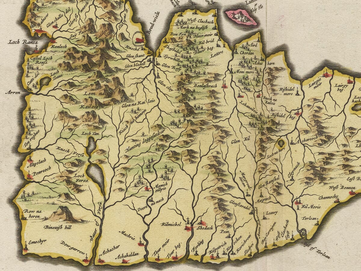
Arran occupies the centre of the composition, surrounded by the waters of the Firth of Clyde. The island is represented with a remarkable density of topographical information. Mountain ranges dominate the interior, while rivers flow toward a carefully drawn coastline. Settlements, castles and other inhabited places are marked throughout the island. A portion of the neighbouring mainland appears at the edge of the sheet, helping to place Arran within its wider geographical setting.
The surviving map is also fascinating for its early forms of familiar Arran place-names. Brodick and its vicinity are recorded on the eastern side of the island, while other settlements preserve spellings dating from a period more than four centuries ago. Such names are particularly valuable because the geographical information ultimately derives from observations made decades before the map was engraved and published.
Blaeu’s map therefore does not simply show Arran as it appeared to a seventeenth-century Amsterdam publisher. Behind it lies Pont’s much earlier first-hand survey of Scotland. The finished engraving brings together two distinct traditions: the practical fieldwork of a Scottish mapmaker and the sophisticated engraving, typography and decorative presentation of the Dutch Golden Age of cartography.
The decorative treatment is characteristic of Blaeu’s finest atlas maps. Ornamental cartouches contain the title and scale, while flowing calligraphy names the surrounding waters. Contemporary examples were often supplied with hand-applied colour, giving individual regions, coastlines and decorative elements the rich appearance now closely associated with Blaeu’s atlases. Surviving institutional copies confirm both the map’s 1654 date and its inclusion in Blaeu’s Scottish atlas.
The map also offers an intriguing comparison with modern Arran. Today the island is often described as “Scotland in miniature” because of the contrast between its mountainous north and gentler southern landscape. On Blaeu’s engraving that physical distinction is already apparent through the dense pictorial hills and waterways with which the interior is depicted. Although the conventions of seventeenth-century cartography are very different from those of a modern Ordnance Survey map, the underlying geographical identity of the island is immediately recognisable.
Brodick Castle provides another connection between the historic map and present-day Arran. A fortified site at Brodick had existed for centuries before Pont undertook his surveys, although the building seen today reflects extensive later alteration. The area around Brodick was strategically important because of its position facing the Ayrshire coast and commanding one of the principal approaches to the island.
For anyone with a connection to Arran, Blaeu’s map provides far more than an attractive decorative image. It preserves early settlements and place-names, records the island before modern roads and scientific surveying, and links Arran with one of the greatest achievements in the history of Scottish cartography. Published in 1654 but rooted in Timothy Pont’s earlier survey work, Arania remains an extraordinary visual record of the Isle of Arran more than four centuries ago.





 Verified owner
















