


£35.95 – £59.95Price range: £35.95 through £59.95
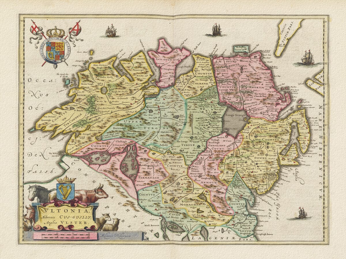
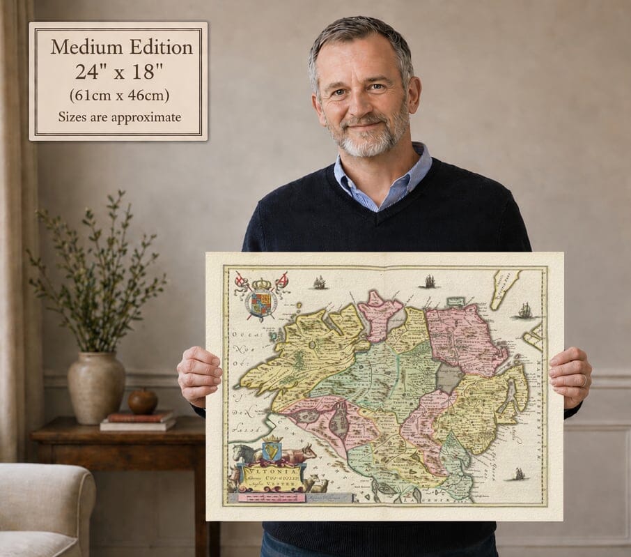
Ulster by Joan Blaeu, first published in Amsterdam in 1654
A particularly pleasing map of historic Ulster, with its counties clearly distinguished by colour. Donegal, Cavan and Monaghan appear alongside the counties of modern Northern Ireland, and the map also includes Louth.
Lough Neagh, the island-filled waters of Lough Erne and the Inishowen peninsula give the landscape its distinctive shape. Sailing ships, royal arms and an animal-decorated title cartouche surround the detailed engraving, reproduced here as a fine art print.
A stunning certified FINE ART PRINT on heavy textured art paper — not a poster
Size
Unlike most online offerings, our maps are produced entirely in-house, not outsourced to print-on-demand or drop-shipping services. This allows complete control over quality while offering better value. Each map begins with a high-resolution original, carefully enhanced and printed to order using archival papers and pigment inks for exceptional clarity, depth, and longevity. Every piece is personally overseen — no map leaves our workshop unless it is of a quality we would be proud to display ourselves.
Paper choice is essential to the authenticity of our maps. We use specially sourced 190gsm paper made in the UK from pure materials and traditionally pressed with natural woollen felts. This process creates a subtle, randomly textured surface that closely resembles an original antique document. Likewise the use of premium quality ink fully saturates the paper, producing remarkable clarity, depth, and historical character. Colour fastness and sharpness will remain good for in excess of 100 years!
The Old Map Company of Great Britain offers a vast and carefully curated collection of the very finest expertly reproduced vintage maps. Our range includes works by renowned cartographers such as John Speed and Willem Blaeu, covering Scotland, England, and beyond. Free UK courier delivery is included, with EU, USA, and worldwide shipping available at cost and calculated at checkout. If you need assistance, our team is always happy to help you choose the perfect map.
Speedy delivery A beautiful representation
Got there in time and loves it! Cheers David [Gift from US to UK]
Thanks Lauren. We received it today - it's gorgeous! Thank you, Ellan
Thank you for your prompt service. I have a gallery and framing business in South Wales. I'm so pleased it is printed in the UK
My Isles of Scilly map arrived safely and I'm delighted with it!
The print arrived safely and we're delighted with it - a lovely reminder of our honeymoon 15 years ago.
I have just received them! I'm sure our clients will be pleased with them and there could be more projects off the back of this one where we can use more. [Interior Designers]
I just received my map of Ireland by Ewart today and, as usual, I am delighted by its quality. The crispness and fineness of detail is excellent and the colour reproduction surpasses my expectations. Please relay my thanks to Steve for another fine effort!
Many thanks, Lauren. Very pleased with the map and the service: would recommend The Old Map Company to anyone interested in Old Maps.
Many thanks, the map arrived safely this morning, and I’m really pleased with it. A stunning reproduction, just as I had hoped. I will keep browsing your website, and may yet be tempted by more of your items! Have a great weekend.
Just arrived, wonderful map! Thanks very much!
The map – beautiful – arrived safely, very many thanks.
Thank you, I have already found the map. It’s wonderfull! Good luck! Rasa
My apologies for the very late reply. I wanted to reach out to thank you so much for rushing my order. My partner absolutely loved it. I am amazed with the service so that is a five-star from me. I wish you all the best.
Published by Joan Blaeu in Amsterdam in 1654, this old map presents Ulster through its counties, waterways and older territorial names. Its title, Ultonia; Hibernis Cui-Guilly; Anglis Ulster, gives names for the province in several languages. The engraved landscape reaches from Donegal’s Atlantic coast to Antrim and Down, extending south through Cavan and Monaghan to include Louth.
The map should not be read as a map of modern Northern Ireland. Historic Ulster encompasses nine counties, including Donegal, Cavan and Monaghan, which are now in the Republic of Ireland. Blaeu’s engraving also places Louth within the coloured area of the province, although Louth belongs to Leinster today. This southern extension is a particularly revealing feature of the map’s inherited geography.
The labels preserve older forms of familiar names. Donegal appears as Tirconnell, while Antrim and Down are written as Antrym and Downe. Across the interior, county names sit beside smaller territorial labels and family names. These layers make the engraving more than a simple diagram of county boundaries.
Lough Neagh forms a dark, conspicuous shape near the centre-right of the sheet. Farther west, the island-filled waters of Lough Erne dominate Fermanagh. Rivers link these inland waters with a coastline broken by bays, headlands and narrow inlets.
Inishowen projects prominently into the northern sea, with Malin at its tip. The long indentations of Lough Swilly and Lough Foyle help distinguish the peninsula from neighbouring Donegal. Across the water, fragments of Scotland appear at the upper-right edge, placing Ulster within its wider maritime setting.
Relief is represented by small pictorial hills, while clusters of trees and settlement symbols provide texture throughout the counties. This is seventeenth-century atlas geography: it records a recognisable landscape without the road network or measured contours expected on a modern map.
The lower-left title cartouche is surrounded by animals, with a horse and horned cattle above the lettering and sheep beside it. A crowned Irish harp rises over the title. These details reward close inspection and give the map a character distinct from Blaeu’s other regional engravings.
Royal arms occupy the upper-left sea, while sailing ships are distributed around the northern and eastern coasts. Beneath the title sit distance scales and Blaeu’s publisher’s imprint. The colouring distinguishes neighbouring districts while leaving the engraved place-names and waterways legible.