John Speed added a short essay which was published on the rear (the verso) of
the map which we have translated into modern English . . .
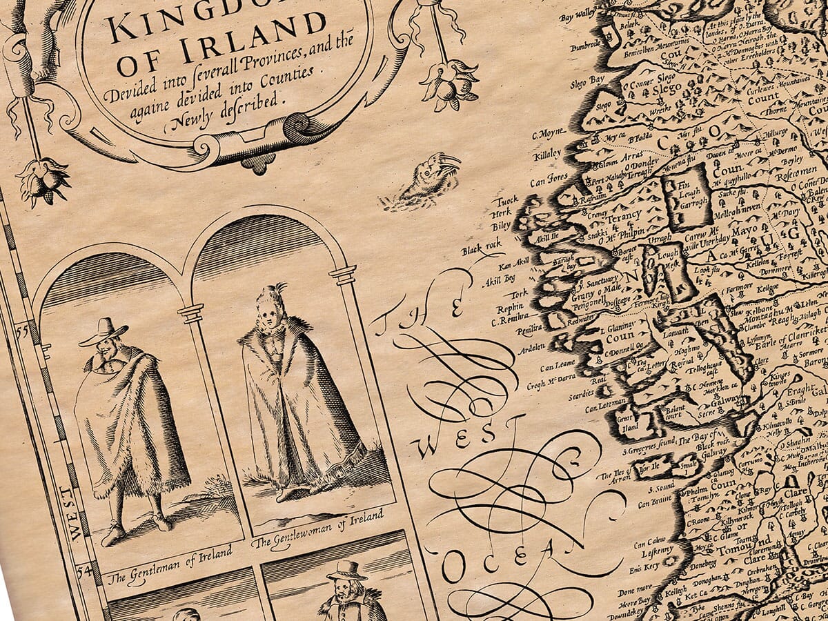
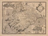
IRELAND,
As it was, and is, inhabited; the location and resources of the island, described and explained.
Traditions have passed down various names by which this famous island has been known. However, none are more likely than the name given by Orpheus, Aristotle, and Claudian, who referred to it as Ierna; by Juvenal and Mela, it was called Juverna; by Diodorus Siculus, Iris; by Martian of Heraclea, Joyepnia; by Eustachius, Oyernia and Bernia; by the native inhabitants, Eryn; by the Britons, Tuerdon; by the Welsh bards in their songs, Tiruolas Totidanan and Banno; and by the English, simply Ireland. From where these different names originated, there are many theories. It is likely that Hibernia, Juverna, and Overnia came from Ierna, as mentioned by Orpheus and Aristotle, while names like Ferna, Iris, suerdhon, and Ireland may derive from Erin, the term now used by the inhabitants. Therefore, the most probable origin of the name is from Erin, a word specific to the nation.
Some people trace Hibernia to Hiberno tempore, meaning “from the winter season,” while others link it to Hiberus, a Spaniard; some suggest it comes from a duke named Irnalph; others say it comes from the ancient river Iberts, or from Heire, an Irish word meaning “west” or “western coast,” because Ireland lies at the furthest west of any European region. Additionally, the river running through the western part of the island is called Fernus by Ptolemy, while Strabo names the western promontory of Spain Jerne, with the river next to it named Ferna by Mela. Spain, being in the west, is called Hesperia; Africa’s western cape is Hesperium, and in Germany, regions like Westphalia derive their names from their western position.
The Roman writer Postelius (who was more imaginative than others) suggested that Ireland’s name came from the Hebrews, claiming Irin might be similar to Jurin, meaning “the land of the Jews.” This theory seems less convincing than the others.
Festus Avienus in his work Ora Maritima calls Ireland the Sacram Insulam, or “holy island,” which many believe is due to the numerous saints the island produced and the fact that it has no venomous creatures, making it a safe and blessed place. It is thought that Plutarch referred to Ireland when he mentioned Ogygia, a very ancient place. Later, Isidore and Bede referred to it as Scotia, after the Scots who inhabited it, and from this term came the name of Scotland.
Ireland, the third-largest island in the world.
In ancient times, Ireland was considered the third-largest island in the known world. Geographers have told us that Taproban (an Indian island) was the largest, followed by Britain, and then Ireland. Because of this, Ptolemy referred to Ireland as Little Britain. While some ancient geographers like Strabo described its shape as square or egg-like, later measurements found it to be much longer than wide, resembling the foreleg of a bear (if the metaphor causes no offense). To the east, it faces the stormy sea that separates it from England, to the west is the Atlantic, to the north is the Deucaledonian Sea, and to the south is the Vergivian Sea.
The air of Ireland.
The air in Ireland is pleasant and healthy, though not as pure or delicate as that of England, which Mela said was not ideal for growing grain. The air in Ireland, however, supports abundant grass, which is sweet for all livestock, and it’s mild enough that the people don’t have to seek shelter from excessive heat or cold. In fact, it’s described as the most temperate of countries, neither too hot nor too cold at any time of year.
The soil.
The soil, according to Cambrenis, is uneven, forested, wild, and boggy, with many lakes and marshes. These watery areas make the land dangerous for newcomers because they can cause illnesses like colds, diarrhea, and stomach problems. The common remedy is Uskebab, a healthy form of brandy that dries the body more than it heats it.
The resources of Ireland.
The island’s wealth lies mainly in its cattle, whose feed is so rich and sweet that they easily grow fat if allowed to graze freely. The sheep are numerous, though their wool is not the finest, being sheared twice a year to make cloaks, capes, and blankets that are exported. Ireland’s horses are highly regarded and comparable to the Jennet horses of Spain. Bees are plentiful, and honey is found in the hollows of old trees and rocks. The absence of dangerous animals makes Ireland a haven for prosperity and pleasure. Giraldus even said that nature had cast a more favorable eye on this western kingdom than on others.
The early inhabitants of Ireland.
As for the ancient settlers of Ireland, their records tell of a woman named Ce Sarea, a niece of Noah, who discovered the island before the Flood. Three hundred years later, when the descendants of Japheth explored the western parts of the world, one of his descendants, Bartholanus (a Scythian), came to Ireland. Along with his three sons, he settled there. They named places after themselves, though over time these names changed. Under the leadership of Bartholanus’ sons, the island was governed for about 300 years. During this time, a race of giant-like people (descendants of Nimrod) came to Ireland, larger than ordinary men. They used their strength to seize power and oppressed others, which led to a great battle. Many giants were slain, and most of the descendants of Japheth died, leaving the island free of their rule.
After this, a Scythian named Nemethus and his four sons arrived in Ireland and managed to settle among the giants. They ruled for 260 years but eventually had to abandon their positions.
Next, five sons of Dela (descendants of Nemethus) came to Ireland and defeated the remaining giants, dividing the land into five regions and becoming its rulers. However, conflict soon broke out between them, and other groups, including the Britons, began to gain influence.
To make Ireland even more legendary, some historians trace the island’s kings to uncertain stories, like Gaothel, a Greek, and Scota (the daughter of King Pharaoh and nurse to Moses), who supposedly came to Spain and then to Ireland, where they named the land Scotia in her honor. This led to the inhabitants being called Scots. These early kings were said to be the ancestors of the people who later conquered Scotland.