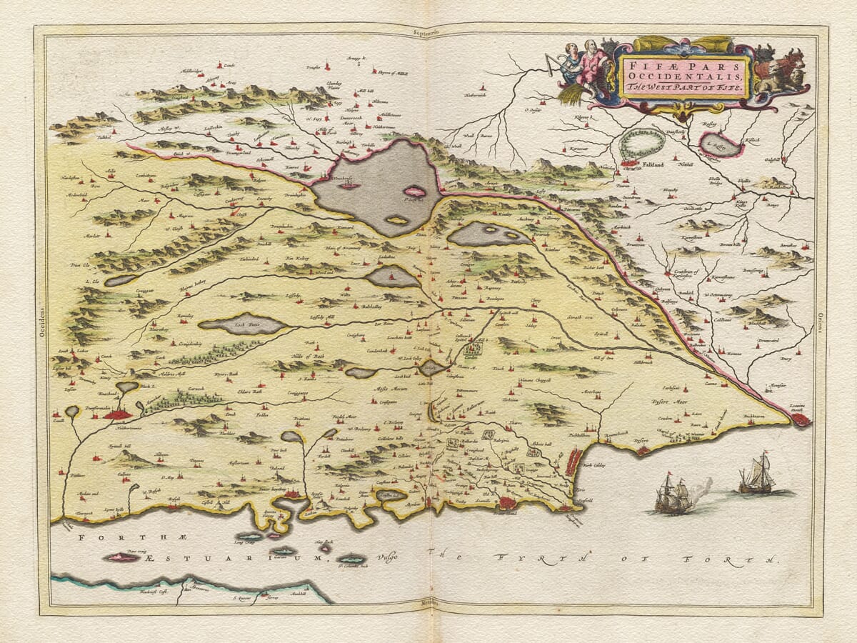
Old map of West Fife by Joan Blaeu after Timothy Pont, 1654
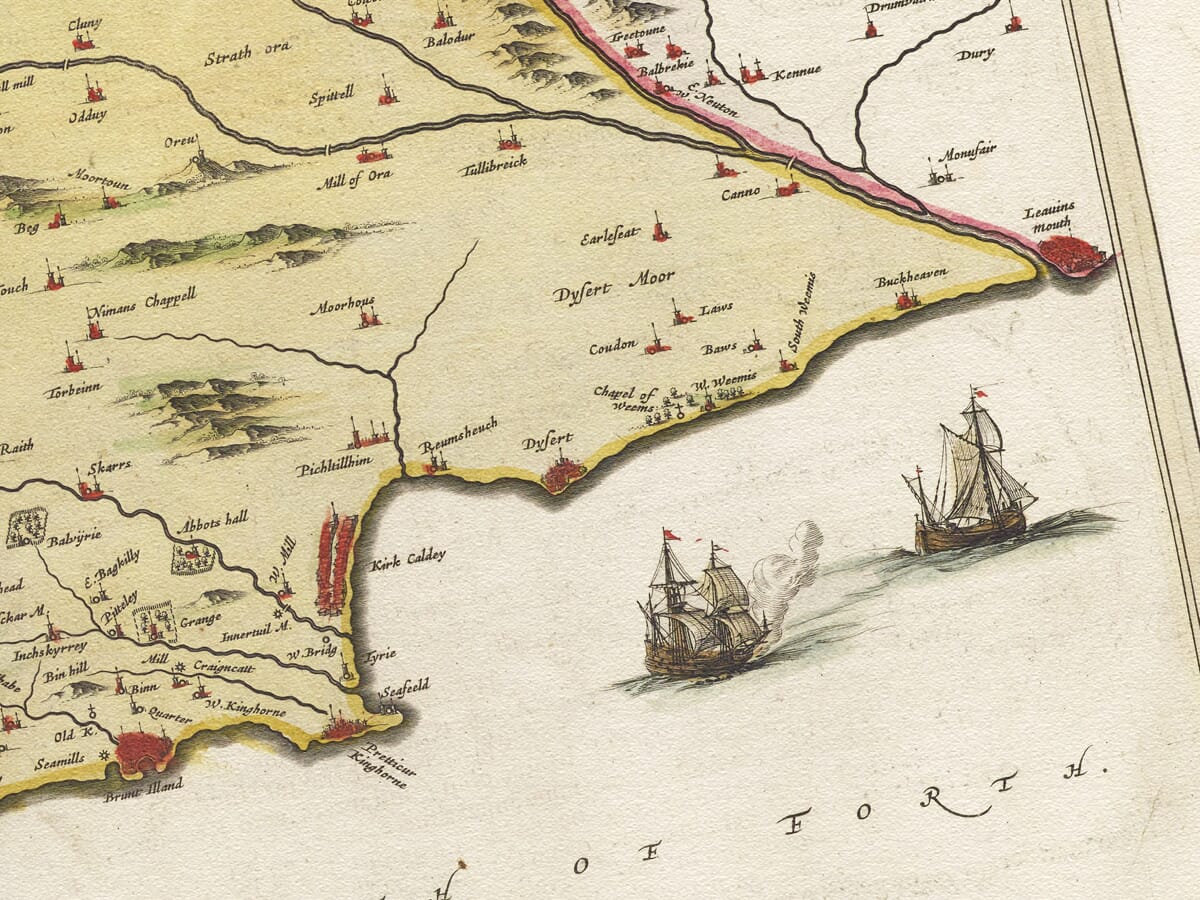
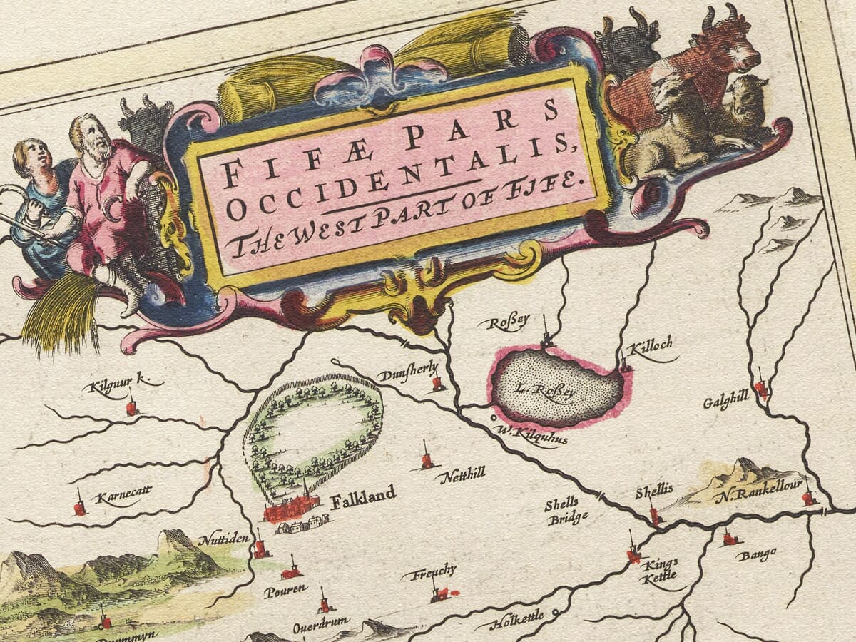
Old map of West Fife by Joan Blaeu after Timothy Pont, 1654 Fife West Map Detail Fife West MapDetail 2

Old Map of West Fife by Joan Blaeu, 1654

Price range: £35.55 through £59.95

From royal Dunfermline to the harbours and ferry towns of the Forth, this old map captures West Fife as a closely woven landscape of ancient burghs, castles, estates and waterside communities. Inland, the engraving reaches towards Loch Leven through country later transformed by mining, industry and expanding towns.

Based upon the pioneering surveys of Timothy Pont, Fifæ Pars Occidentalis — The West Part of Fife was published by Joan Blaeu in Amsterdam in 1654. Its early place names preserve a view of the region whose origins reach back towards the closing years of the sixteenth century.

Finely engraved waterways, pictorial hills and settlement symbols surround an ornamental title cartouche. Reproduced as a fine art print on subtly textured paper, this historic map offers an enduring connection with Dunfermline, the Forth coast and the communities of western Fife.
+ read more

A stunning certified FINE ART PRINT on heavy textured art paper — not a poster

  • Direct from the publisher — no middlemen
  • Printed in-house in Cornwall
  • Free UK delivery — international shipping available
  • Produced to meet — and often exceed — museum-quality standards

SELECT SIZE

Inspecting Vintage Map Reproduction

Fine Art Map Reproductions – Museum-Quality Printing

Unlike most online offerings, our maps are produced entirely in-house, not outsourced to print-on-demand or drop-shipping services. This allows complete control over quality while offering better value. Each map begins with a high-resolution original, carefully enhanced and printed to order using archival papers and pigment inks for exceptional clarity, depth, and longevity. Every piece is personally overseen — no map leaves our workshop unless it is of a quality we would be proud to display ourselves.

Hand hold a magnifying glass over West Cornwall Map

Authentic Old Map Paper & Accurate Colour Reproduction

Paper choice is essential to the authenticity of our maps. We use specially sourced 190gsm paper made in the UK from pure materials and traditionally pressed with natural woollen felts. This process creates a subtle, randomly textured surface that closely resembles an original antique document. Likewise the use of premium quality ink fully saturates the paper, producing remarkable clarity, depth, and historical character. Colour fastness and sharpness will remain good for in excess of 100 years!

Map in Postal Tube
Buy Old Maps Online in the UK Today Trading online since 1999

The Old Map Company of Great Britain offers a vast and carefully curated collection of the very finest expertly reproduced vintage maps. Our range includes works by renowned cartographers such as John Speed and Willem Blaeu, covering Scotland, England, and beyond. Free UK courier delivery is included, with EU, USA, and worldwide shipping available at cost and calculated at checkout. If you need assistance, our team is always happy to help you choose the perfect map.

RECENT REVIEWS

Daz
DazGB
Verified ownerVerified owner
5/5

Speedy delivery A beautiful representation

2 months ago
David H
David H
Verified ownerVerified owner
5/5

Got there in time and loves it! Cheers David [Gift from US to UK]

4 months ago
Ellan C-S
Ellan C-S
Verified ownerVerified owner
5/5

Thanks Lauren. We received it today - it's gorgeous! Thank you, Ellan

4 months ago
Ivano Di Battista
Ivano Di Battista
Verified ownerVerified owner
5/5

Thank you for your prompt service. I have a gallery and framing business in South Wales. I'm so pleased it is printed in the UK

4 months ago
Robert B
Robert B
Verified ownerVerified owner
5/5

My Isles of Scilly map arrived safely and I'm delighted with it!

5 months ago
Andrew T
Andrew T
Reviewer
5/5

The print arrived safely and we're delighted with it - a lovely reminder of our honeymoon 15 years ago.

5 months ago
Hannah J
Hannah J
Verified ownerVerified owner
5/5

I have just received them! I'm sure our clients will be pleased with them and there could be more projects off the back of this one where we can use more. [Interior Designers]

5 months ago
Sean MacManus
Sean MacManus
Verified ownerVerified owner
5/5

I just received my map of Ireland by Ewart today and, as usual, I am delighted by its quality. The crispness and fineness of detail is excellent and the colour reproduction surpasses my expectations. Please relay my thanks to Steve for another fine effort!

5 months ago
John G
John G
Verified ownerVerified owner
5/5

Many thanks, Lauren. Very pleased with the map and the service: would recommend The Old Map Company to anyone interested in Old Maps.

7 months ago
Lois K
Lois K
Verified ownerVerified owner
5/5

Thrilled , Lauren! Thank You

7 months ago
Ed Simpson
Ed Simpson
Verified ownerVerified owner
5/5

Many thanks, the map arrived safely this morning, and I’m really pleased with it. A stunning reproduction, just as I had hoped. I will keep browsing your website, and may yet be tempted by more of your items! Have a great weekend.

7 months ago
Daniel McCade
Daniel McCade
Verified ownerVerified owner
5/5

Just arrived, wonderful map! Thanks very much!

8 months ago
Jonathon R
Jonathon R
Verified ownerVerified owner
5/5

The map – beautiful – arrived safely, very many thanks.

1 year ago
Rasa Terbetiene
Rasa Terbetiene
Verified ownerVerified owner
5/5

Thank you, I have already found the map. It’s wonderfull! Good luck! Rasa

4 years ago
Mina M.
Mina M.
Verified ownerVerified owner
5/5

My apologies for the very late reply. I wanted to reach out to thank you so much for rushing my order. My partner absolutely loved it. I am amazed with the service so that is a five-star from me. I wish you all the best.

4 years ago

Joan Blaeu’s Old Map of West Fife

Joan Blaeu’s old map of West Fife was first published in Amsterdam in 1654 as part of the fifth volume of his Theatrum Orbis Terrarum, sive Atlas Novus. Its engraved title, Fifæ Pars Occidentalis — The West Part of Fife, identifies it as the companion to Blaeu’s separate and overlapping map of East Fife.

The map concentrates upon western and central Fife, tracing a landscape of royal burghs, coastal settlements, lochs, rivers, estates and early industrial communities. Its geographical information reflects Scotland as recorded before modern roads, railways and the later expansion of the mining towns.

Map details

  • Original title: Fifæ Pars Occidentalis — The West Part of Fife
  • Region shown: Western and central Fife, from the Forth coast towards Loch Leven
  • Original survey: Timothy Pont
  • Publisher: Joan Blaeu
  • First published: Amsterdam, 1654
  • Atlas: Theatrum Orbis Terrarum, sive Atlas Novus, Part Five
  • Format: Copperplate engraving, with colour added separately to some original impressions
  • Product type: Fine art reproduction map print

Timothy Pont and the First Survey of Scotland

The map’s geographical foundations came from Timothy Pont, the pioneering Scottish surveyor who travelled through much of the country during the late sixteenth century. Pont recorded towns, villages, castles, estates, rivers and local place names with a degree of detail previously unknown in Scottish mapping.

Pont died before his proposed atlas could be published. His manuscript maps were subsequently preserved and sent to the Blaeu workshop in Amsterdam, where they were organised and prepared for engraving. Robert Gordon of Straloch and his son James Gordon assisted with the wider task of reviewing the Scottish material, although modern research indicates that the two larger maps of East and West Fife were probably derived substantially from Pont’s earlier work.

The West Fife plate therefore presents an intriguing combination of dates. It was published by Joan Blaeu in 1654, but much of the landscape and settlement information may reflect Pont’s observations from the 1580s and 1590s. In this sense, the engraving preserves a view of western Fife reaching back towards the reign of James VI.

From Dunfermline to the Firth of Forth

Dunfermline occupies an important position within the map. The town’s royal abbey, palace and associations with generations of Scottish monarchs made it one of the most historically significant places in Fife. Long before its later industrial expansion, Dunfermline was already a royal burgh and an established centre of religion, administration and commerce.

South of the town, the coastline of the Firth of Forth is marked by a succession of settlements with longstanding maritime connections. Inverkeithing, Aberdour, Burntisland and Kinghorn served as harbours, ferry points and trading communities. Kirkcaldy appears farther east within the area shared with Blaeu’s companion map.

The waterways of the Forth connected these communities with Edinburgh, the Lothians and trading ports farther afield. Fishing, coastal transport and commerce were essential parts of life, while the fortified houses and estates depicted inland reflect a landscape shaped by powerful families and inherited landholding.

Northwards, the map reaches through the interior of Fife towards Loch Leven and the surrounding hills. Smaller communities recorded in this country include places that later grew with coal mining and manufacturing, alongside others that remained villages, farms or estates.

The map is particularly valuable for its early place names. Some appear in spellings close to those used today, while others were recorded phonetically or altered during the engraving process. A few identify settlements and properties that have since disappeared or been absorbed into larger towns.

Reading the Seventeenth-Century Map

This is not a measured topographical survey in the modern sense. Hills are represented pictorially, waterways are emphasised and settlements are indicated by conventional groups of buildings. Castles and important houses may be distinguished by their symbols, but roads are not shown systematically.

The map also contains geographical inaccuracies. Research comparing Blaeu’s three Fife plates has demonstrated that the separate East and West maps are less precise than James Gordon’s later map of the complete county. One example concerns the lochs north of Burntisland, whose names and positions became confused in the western plate.

Such imperfections are historically valuable. They show how geographical knowledge travelled from a surveyor’s field notes through manuscript copies and revisions before reaching an engraver in Amsterdam. The map records not only the landscape but also the process by which seventeenth-century Scotland was interpreted for an international audience.

Three Different Views of Fife

Blaeu’s atlas contains three maps covering Fife: this western plate, its companion map of East Fife and a smaller-scale map of the whole county.

The maps overlap, but they are not merely enlargements of the same information. The two regional plates appear to preserve older material associated with Pont, while the complete county map reflects the later work of James Gordon. Place names, settlement density and geographical detail consequently differ between them.

The ornate title cartouche, engraved lettering and delicately drawn landscape give Fifæ Pars Occidentalis the decorative quality associated with Blaeu’s workshop. More than three and a half centuries later, it remains an absorbing historic map of Dunfermline, the Forth coast and the old communities of western Fife.

You may also like…

×
Product added to cart
No products in the cart.