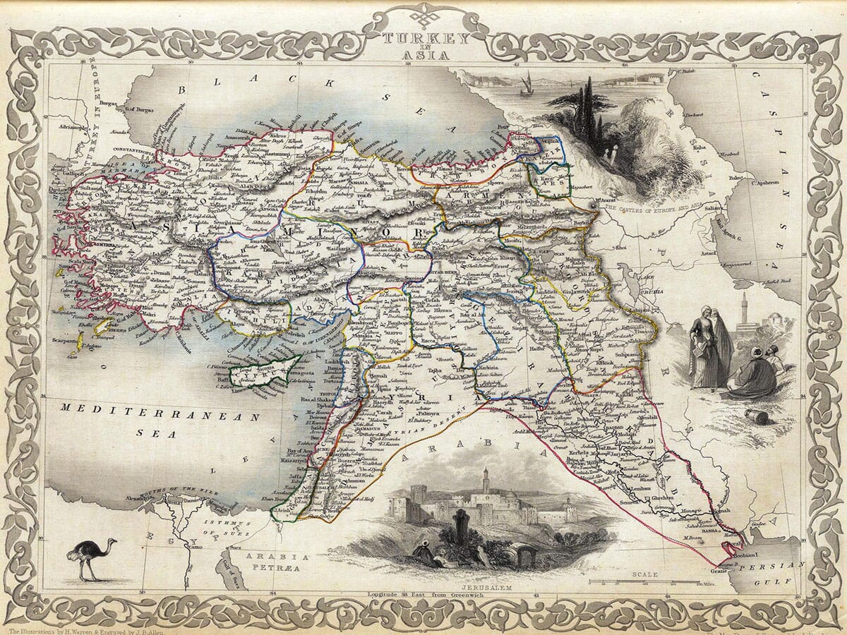
Tallis map of Turkey in Asia with coloured regional outlines, Cyprus, a Jerusalem view and an ornamental border
Tallis map of Turkey in Asia with coloured regional outlines, Cyprus, a Jerusalem view and an ornamental border Old Map Turkey & Asia Detail Old Map Turkey & Asia

Old Map of Turkey in Asia

Price range: £35.55 through £59.95

Old Map of Turkey in Asia by John Rapkin, published by J. & F. Tallis, circa 1851

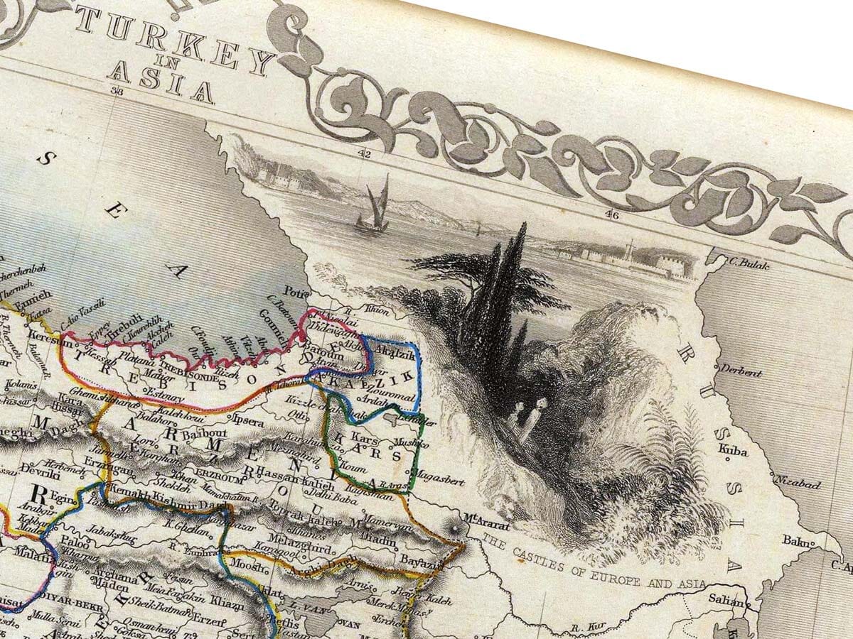
An illustrated map of the Ottoman Empire’s Asian territories, extending from Anatolia and Cyprus through Syria and Palestine towards the Persian Gulf. Coloured regional outlines and densely engraved rivers, mountains and settlements are surrounded by an ornamental border.

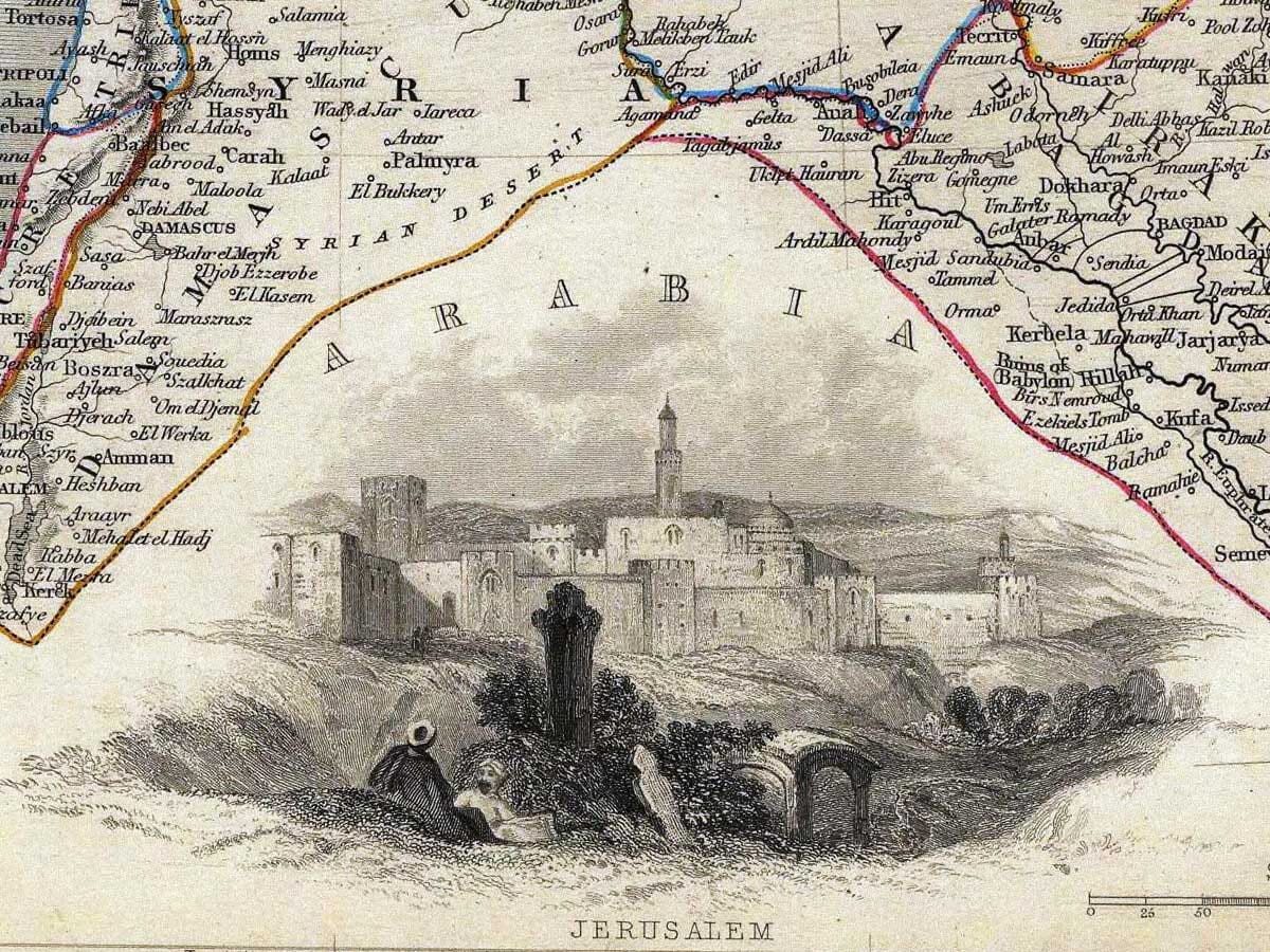
A view of Jerusalem, the Castles of Europe and Asia, figures in historical dress and an ostrich add the distinctive pictorial detail of Tallis’s atlas. Reproduced as a giclée fine art print and supplied unframed.

+ read more

A stunning certified FINE ART PRINT on heavy textured art paper — not a poster

  • Direct from the publisher — no middlemen
  • Printed in-house in Cornwall
  • Free UK delivery — international shipping available
  • Produced to meet — and often exceed — museum-quality standards

SELECT SIZE

Inspecting Mercator's 1623 old map of Great Britain and Ireland

Fine Art Map Reproductions – Museum-Quality Printing

Unlike most online offerings, our maps are produced entirely in-house, not outsourced to print-on-demand or drop-shipping services. This allows complete control over quality while offering better value. Each map begins with a high-resolution original, carefully enhanced and printed to order using archival papers and pigment inks for exceptional clarity, depth, and longevity. Every piece is personally overseen — no map leaves our workshop unless it is of a quality we would be proud to display ourselves.

Hand hold a magnifying glass over West Cornwall Map

Authentic Old Map Paper & Accurate Colour Reproduction

Paper choice is essential to the authenticity of our maps. We use specially sourced 190gsm paper made in the UK from pure materials and traditionally pressed with natural woollen felts. This process creates a subtle, randomly textured surface that closely resembles an original antique document. Likewise the use of premium quality ink fully saturates the paper, producing remarkable clarity, depth, and historical character. Colour fastness and sharpness will remain good for in excess of 100 years!

Map in Postal Tube
Buy Old Maps Online in the UK Today Trading online since 1999

The Old Map Company of Great Britain offers a vast and carefully curated collection of the very finest expertly reproduced vintage maps. Our range includes works by renowned cartographers such as John Speed and Willem Blaeu, covering Scotland, England, and beyond. Free UK courier delivery is included, with EU, USA, and worldwide shipping available at cost and calculated at checkout. If you need assistance, our team is always happy to help you choose the perfect map.

RECENT REVIEWS

Daz
DazGB
Verified ownerVerified owner
5/5

Speedy delivery A beautiful representation

3 months ago
David H
David H
Verified ownerVerified owner
5/5

Got there in time and loves it! Cheers David [Gift from US to UK]

5 months ago
Ellan C-S
Ellan C-S
Verified ownerVerified owner
5/5

Thanks Lauren. We received it today - it's gorgeous! Thank you, Ellan

5 months ago
Ivano Di Battista
Ivano Di Battista
Verified ownerVerified owner
5/5

Thank you for your prompt service. I have a gallery and framing business in South Wales. I'm so pleased it is printed in the UK

5 months ago
Robert B
Robert B
Verified ownerVerified owner
5/5

My Isles of Scilly map arrived safely and I'm delighted with it!

5 months ago
Andrew T
Andrew T
Reviewer
5/5

The print arrived safely and we're delighted with it - a lovely reminder of our honeymoon 15 years ago.

6 months ago
Hannah J
Hannah J
Verified ownerVerified owner
5/5

I have just received them! I'm sure our clients will be pleased with them and there could be more projects off the back of this one where we can use more. [Interior Designers]

6 months ago
Sean MacManus
Sean MacManus
Verified ownerVerified owner
5/5

I just received my map of Ireland by Ewart today and, as usual, I am delighted by its quality. The crispness and fineness of detail is excellent and the colour reproduction surpasses my expectations. Please relay my thanks to Steve for another fine effort!

6 months ago
John G
John G
Verified ownerVerified owner
5/5

Many thanks, Lauren. Very pleased with the map and the service: would recommend The Old Map Company to anyone interested in Old Maps.

8 months ago
Lois K
Lois K
Verified ownerVerified owner
5/5

Thrilled , Lauren! Thank You

8 months ago
Ed Simpson
Ed Simpson
Verified ownerVerified owner
5/5

Many thanks, the map arrived safely this morning, and I’m really pleased with it. A stunning reproduction, just as I had hoped. I will keep browsing your website, and may yet be tempted by more of your items! Have a great weekend.

8 months ago
Daniel McCade
Daniel McCade
Verified ownerVerified owner
5/5

Just arrived, wonderful map! Thanks very much!

9 months ago
Jonathon R
Jonathon R
Verified ownerVerified owner
5/5

The map – beautiful – arrived safely, very many thanks.

1 year ago
Rasa Terbetiene
Rasa Terbetiene
Verified ownerVerified owner
5/5

Thank you, I have already found the map. It’s wonderfull! Good luck! Rasa

4 years ago
Mina M.
Mina M.
Verified ownerVerified owner
5/5

My apologies for the very late reply. I wanted to reach out to thank you so much for rushing my order. My partner absolutely loved it. I am amazed with the service so that is a five-star from me. I wish you all the best.

4 years ago

Historical Background

John Rapkin’s Turkey in Asia, published by J. & F. Tallis around 1851, brings together the Ottoman Empire’s Asian territories on a single illustrated sheet. Anatolia occupies the left half, while Syria, Palestine and the country around the Tigris and Euphrates extend towards the Persian Gulf. The map belongs to Tallis’s Illustrated Atlas, edited by R. Montgomery Martin. Its geographical engraving is accompanied by illustrations credited to H. Warren and engraved by J. B. Allen.

Map Details

  • Original title: Turkey in Asia
  • Mapmaker and engraver: John Rapkin
  • Publisher: J. & F. Tallis
  • Illustrations: H. Warren, engraved by J. B. Allen
  • Date: Circa 1851; the precise atlas issue of this example is unconfirmed
  • Source publication: The Illustrated Atlas, edited by R. Montgomery Martin
  • Publication centres: London and New York
  • Area shown: Anatolia and neighbouring Ottoman territories in western Asia, with Cyprus and adjoining parts of Arabia, Persia and the Caucasus
  • Orientation: North at the top
  • Format: Engraved atlas map with coloured regional outlines, pictorial views and an ornamental border

What “Turkey in Asia” means

The title uses a nineteenth-century geographical expression for the Asian lands of the Ottoman Empire. It does not mean Turkey alongside a separate map of the whole Asian continent. Nor does the sheet represent the borders of the modern Republic of Turkey. Its broad coverage places territories now belonging to several countries within the geographical framework used by a Victorian atlas.

The distinction is visible in the arrangement of the names. Asia Minor stretches across Anatolia, while Syria appears farther south. Armenia and Kurdistan occupy parts of the mountainous eastern country. These historical labels overlap a complicated landscape of settlements, rivers and smaller districts; they should not be read as a straightforward set of present-day national boundaries.

From Constantinople to Cyprus

Constantinople appears near the western edge, where the Black Sea approaches the narrow passage into the Sea of Marmara. The surrounding coast is densely named, and a small portion of European territory is included to complete this setting. Across Anatolia, clusters of settlements follow the coast and the valleys between engraved mountain ranges.

Cyprus is shown separately in the eastern Mediterranean, outlined in green and filled with place names. Its position between Anatolia and the Levant is particularly clear on this sheet. The broad expanse of sea provides breathing space beside the much denser land engraving, allowing the island and the neighbouring coastline to stand out.

The rivers towards the Persian Gulf

Farther east, the Tigris and Euphrates are important threads through the map. Their courses can be followed from the northern country towards the lowlands and the head of the Persian Gulf. Baghdad and Basra are among the named settlements in this eastern part of the sheet.

The coloured lines distinguish regions without obscuring the fine black engraving beneath them. Mountains are suggested through shaded strokes, while rivers, towns and coastal features receive closely packed lettering. Looking at the print in detail reveals a different level of information from the large regional names visible at a distance.

Jerusalem and the decorative views

A substantial view labelled Jerusalem fills the lower centre. Buildings and walls rise beyond a rocky foreground, with figures placed outside the city. This is a separate illustration rather than an enlargement of the cartographic town symbol: its role is to give the reader a pictorial impression alongside the geographical information.

Another view near the upper right is labelled the Castles of Europe and Asia. Below it, a group of figures in historical dress occupies the margin beside the map’s eastern territories. An ostrich stands at the lower left. These images reflect the visual conventions of the British atlas publisher, rather than offering a comprehensive portrait of the region’s varied peoples and landscapes.

A richly worked Victorian atlas sheet

The scrolling ornamental border surrounds both map and pictures, with the title incorporated at the top. The illustrations are fitted into comparatively open areas, creating an intricate composition without dividing the sheet into conventional rectangular panels. A mileage scale and the longitude reference remain visible along the lower edge.

As an old map print, its interest lies in this combination of detailed regional geography and carefully engraved illustration. It records historical names and territorial relationships while retaining the distinctive presentation of Tallis’s atlas. The fine art reproduction preserves that arrangement, including the coloured outlines, decorative surround and contrasting views.

You may also like…

  • Detail from an old map of EuropeEurope in 1650Add to Basket This product has multiple variants. The options may be chosen on the product page

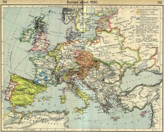
    Europe 1560

    Price range: £35.55 through £59.95
  • Old map of Cyprus by Willem Blaeu, 1635Add to Basket This product has multiple variants. The options may be chosen on the product page

    Cyprus

    Price range: £35.55 through £59.95
  • Tartaray.Old Map of TurkeyAdd to Basket This product has multiple variants. The options may be chosen on the product page

    Old Map of the Turkish Empire by John Speed, 1626

    Price range: £35.55 through £59.95
×
Product added to cart
No products in the cart.