J. Ross Brown’s Map of Stratford-upon-Avon, 1908
J. Ross Brown’s Map of Stratford-upon-Avon, 1908 Stratford map detail Stratford-upon-Avon

Old Map of Stratford-upon-Avon by J. Ross Brown, 1908

Price range: £35.55 through £59.95

Pictorial map of Stratford-upon-Avon created by J. Ross Brown in 1908, with early photographic views of Shakespearean landmarks.

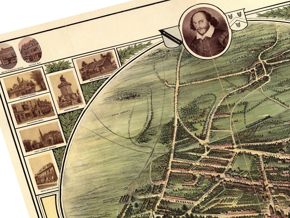
Discover Stratford-upon-Avon as visitors encountered it at the beginning of the twentieth century. J. Ross Brown’s colourful bird’s-eye map follows the streets surrounding Shakespeare’s Birthplace, New Place, Holy Trinity Church, the Guild Chapel and the banks of the River Avon.

Around the map, a remarkable sequence of photographs presents Anne Hathaway’s Cottage, Harvard House, Clopton Bridge, the Shakespeare Memorial Theatre and other celebrated buildings. Letters and numbers connect important landmarks with a convenient reference key, giving the design the character of both a town plan and an illustrated visitor’s guide.

Created in 1908, the map captures Stratford before modern development transformed its outskirts and before the original Memorial Theatre was destroyed by fire. Reproduced as a fine art print, it offers an absorbing portrait of Shakespeare’s town during the early years of popular cultural tourism.
+ read more

A stunning certified FINE ART PRINT on heavy textured art paper — not a poster

  • Direct from the publisher — no middlemen
  • Printed in-house in Cornwall
  • Free UK delivery — international shipping available
  • Produced to meet — and often exceed — museum-quality standards

SELECT SIZE

Inspecting Vintage Map Reproduction

Fine Art Map Reproductions – Museum-Quality Printing

Unlike most online offerings, our maps are produced entirely in-house, not outsourced to print-on-demand or drop-shipping services. This allows complete control over quality while offering better value. Each map begins with a high-resolution original, carefully enhanced and printed to order using archival papers and pigment inks for exceptional clarity, depth, and longevity. Every piece is personally overseen — no map leaves our workshop unless it is of a quality we would be proud to display ourselves.

Hand hold a magnifying glass over West Cornwall Map

Authentic Old Map Paper & Accurate Colour Reproduction

Paper choice is essential to the authenticity of our maps. We use specially sourced 190gsm paper made in the UK from pure materials and traditionally pressed with natural woollen felts. This process creates a subtle, randomly textured surface that closely resembles an original antique document. Likewise the use of premium quality ink fully saturates the paper, producing remarkable clarity, depth, and historical character. Colour fastness and sharpness will remain good for in excess of 100 years!

Map in Postal Tube
Buy Old Maps Online in the UK Today Trading online since 1999

The Old Map Company of Great Britain offers a vast and carefully curated collection of the very finest expertly reproduced vintage maps. Our range includes works by renowned cartographers such as John Speed and Willem Blaeu, covering Scotland, England, and beyond. Free UK courier delivery is included, with EU, USA, and worldwide shipping available at cost and calculated at checkout. If you need assistance, our team is always happy to help you choose the perfect map.

RECENT REVIEWS

Daz
DazGB
Verified ownerVerified owner
5/5

Speedy delivery A beautiful representation

2 months ago
David H
David H
Verified ownerVerified owner
5/5

Got there in time and loves it! Cheers David [Gift from US to UK]

4 months ago
Ellan C-S
Ellan C-S
Verified ownerVerified owner
5/5

Thanks Lauren. We received it today - it's gorgeous! Thank you, Ellan

4 months ago
Ivano Di Battista
Ivano Di Battista
Verified ownerVerified owner
5/5

Thank you for your prompt service. I have a gallery and framing business in South Wales. I'm so pleased it is printed in the UK

4 months ago
Robert B
Robert B
Verified ownerVerified owner
5/5

My Isles of Scilly map arrived safely and I'm delighted with it!

5 months ago
Andrew T
Andrew T
Reviewer
5/5

The print arrived safely and we're delighted with it - a lovely reminder of our honeymoon 15 years ago.

5 months ago
Hannah J
Hannah J
Verified ownerVerified owner
5/5

I have just received them! I'm sure our clients will be pleased with them and there could be more projects off the back of this one where we can use more. [Interior Designers]

5 months ago
Sean MacManus
Sean MacManus
Verified ownerVerified owner
5/5

I just received my map of Ireland by Ewart today and, as usual, I am delighted by its quality. The crispness and fineness of detail is excellent and the colour reproduction surpasses my expectations. Please relay my thanks to Steve for another fine effort!

5 months ago
John G
John G
Verified ownerVerified owner
5/5

Many thanks, Lauren. Very pleased with the map and the service: would recommend The Old Map Company to anyone interested in Old Maps.

7 months ago
Lois K
Lois K
Verified ownerVerified owner
5/5

Thrilled , Lauren! Thank You

7 months ago
Ed Simpson
Ed Simpson
Verified ownerVerified owner
5/5

Many thanks, the map arrived safely this morning, and I’m really pleased with it. A stunning reproduction, just as I had hoped. I will keep browsing your website, and may yet be tempted by more of your items! Have a great weekend.

7 months ago
Daniel McCade
Daniel McCade
Verified ownerVerified owner
5/5

Just arrived, wonderful map! Thanks very much!

8 months ago
Jonathon R
Jonathon R
Verified ownerVerified owner
5/5

The map – beautiful – arrived safely, very many thanks.

1 year ago
Rasa Terbetiene
Rasa Terbetiene
Verified ownerVerified owner
5/5

Thank you, I have already found the map. It’s wonderfull! Good luck! Rasa

4 years ago
Mina M.
Mina M.
Verified ownerVerified owner
5/5

My apologies for the very late reply. I wanted to reach out to thank you so much for rushing my order. My partner absolutely loved it. I am amazed with the service so that is a five-star from me. I wish you all the best.

4 years ago

J. Ross Brown’s Pictorial Map of Stratford-upon-Avon

J. Ross Brown’s pictorial map of Stratford-upon-Avon was created in 1908, when the Warwickshire town was already internationally celebrated as the birthplace of William Shakespeare. Entitled Stratford on Avon, it combines a colourful bird’s-eye plan with photographs of historic buildings, hotels, monuments and riverside attractions.

This is not a precisely measured Ordnance Survey plan. Instead, Brown designed an accessible visual guide that allowed visitors to understand the town, identify its Shakespearean landmarks and recognise important buildings from the photographs arranged around the edges.

Map Details

  • Original title: Stratford on Avon
  • Creator: J. Ross Brown
  • Date: 1908
  • Place shown: Stratford-upon-Avon, Warwickshire
  • Map type: Pictorial bird’s-eye town plan with photographic border
  • Scale: Not drawn to scale
  • Original dimensions: Approximately 490 × 660 mm
  • Principal features: Town centre, River Avon, Clopton Bridge, railway lines and surrounding roads
  • Key landmarks: Shakespeare’s Birthplace, New Place, Holy Trinity Church, Harvard House, the Guild Chapel and School, Shakespeare Memorial Theatre and Anne Hathaway’s Cottage
  • Format: Colour-printed map accompanied by monochrome photographic views

Shakespeare’s Stratford-upon-Avon

The central map presents Stratford through its close association with Shakespeare. His birthplace in Henley Street is identified prominently, while New Place marks the site of the house in which he spent his later years. Holy Trinity Church, where Shakespeare was baptised and buried, stands beside the Avon.

The Guild Chapel and adjoining school recall the medieval Stratford in which Shakespeare grew up. Harvard House, an elaborately decorated timber-framed building in the High Street, is another recognisable landmark included in Brown’s key.

These buildings are not treated as isolated monuments. Streets, houses, businesses and public buildings surround them, showing how Shakespearean sites formed part of a living and increasingly busy market town.

A Town Shaped by Visitors

By 1908, Stratford-upon-Avon had been attracting literary pilgrims for generations. The Shakespeare Birthplace Trust had been founded in 1847, and the arrival of the railway in 1864 made the town considerably easier to reach from Birmingham, London and other parts of Britain.

Brown’s map belongs to this growing culture of Shakespearean tourism. Its clear reference key, picturesque colouring and border photographs made it practical as a guide while also creating an attractive souvenir of a visit.

Hotels and restaurants consequently receive unusual prominence. The White Swan Hotel, Shakespeare Hotel, Golden Bee Restaurant, Fountain Restaurant and Swan’s Nest Hotel all appear in the photographs or reference key. Their inclusion reveals that the map was intended not merely to record the town but to help visitors find their way around it.

The Memorial Theatre and River Avon

The Shakespeare Memorial Theatre appears beside the River Avon. Opened in 1879, this Gothic Revival building was the home of Stratford’s annual Shakespeare festival and an important predecessor of today’s Royal Shakespeare Theatre.

Brown’s map preserves the original theatre before it was severely damaged by fire in 1926. Its replacement opened in 1932 and was later incorporated into the present Royal Shakespeare Company complex.

The river provides one of the composition’s strongest visual features. Clopton Bridge crosses the Avon to the east of the town centre, while the Memorial Theatre, riverside paths and Swan’s Nest boating facilities reflect the importance of the waterfront to Edwardian visitors.

Photographs Around the Map

Small photographs arranged around the upper and side margins turn the map into an illustrated portrait of Stratford. Among the subjects are Shakespeare’s Birthplace and Birth Room, Anne Hathaway’s Cottage, Holy Trinity Church, Harvard House, the Guild Chapel and School, Clopton Bridge and Gower’s Shakespeare Monument.

The border also records shops, restaurants, hotels and private houses that formed part of the town in 1908. Some survive in recognisable form, while others have disappeared or acquired completely different uses.

Together, these pictures allow the viewer to compare the simplified forms on the map with the buildings as they actually appeared at the beginning of the twentieth century.

Reading the Bird’s-Eye Map

Brown uses an elevated viewpoint rather than the directly overhead perspective of a conventional street plan. Buildings are drawn individually, important landmarks are emphasised and roads have been widened sufficiently to remain clear.

Because the map is not drawn to scale, distances should not be measured from it. Its purpose is visual orientation: showing how the historic centre, railway approaches, river and principal visitor attractions relate to one another.

Letters identify the principal Shakespearean sites, while numbered references locate selected hotels, restaurants and residences. The result is an engaging mixture of map, townscape, photograph album and tourist guide.

Created in 1908, this old map captures Stratford-upon-Avon at a revealing moment in its history. The medieval street pattern and Shakespearean buildings remain at its heart, but railways, hotels, organised sightseeing and the Memorial Theatre demonstrate how the town had developed into an international cultural destination.

You may also like…

×
Product added to cart
No products in the cart.