Mapping the Solomon Islands and the South Pacific
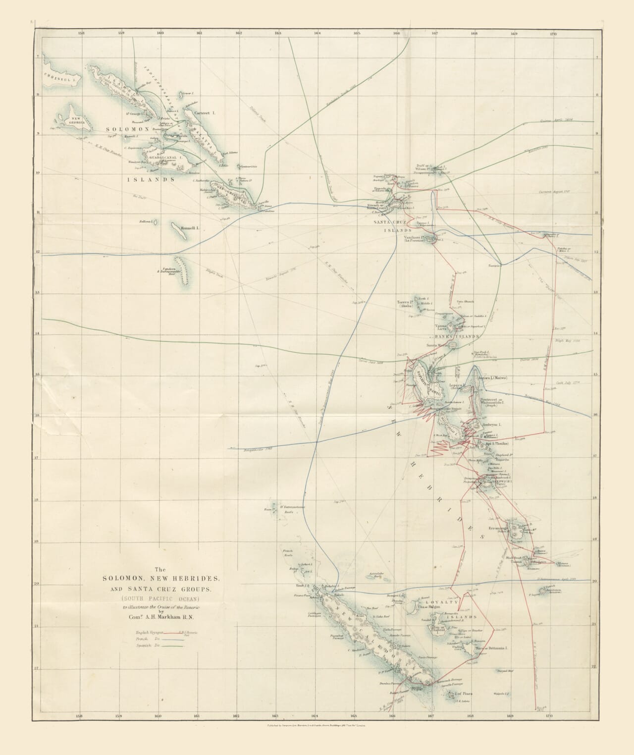
Published in 1872, this map brings together the Solomon Islands, Santa Cruz Islands and New Hebrides within one long view of the south-western Pacific. It was created to illustrate a paper by Lieutenant Albert Hastings Markham in Volume 42 of the Journal of the Royal Geographical Society of London. Rather than presenting the Solomon Islands alone, it records the wider ocean through which ships approached and travelled between these geographically separated island groups.
Map Details
Original title: The Solomon, New Hebrides, and Santa Cruz Groups (South Pacific Ocean)
Purpose: To illustrate a paper by Lieutenant A. H. Markham, Royal Navy
Published by: The Royal Geographical Society
Publisher: John Murray
Published: London, 1872
Original medium: Engraved map with colour added to selected routes and boundaries
Area shown: The Solomon Islands, Santa Cruz Islands and New Hebrides, now Vanuatu
Notable features: Historical voyage tracks, island names, reefs, coastlines, volcanoes, latitude and longitude lines, relief shown by hachures and depth contours
The Solomon chain occupies the upper-left portion of the map. Among the islands that can be found are Bougainville, Choiseul, New Georgia, Isabel, Guadalcanal, Malaita and San Cristobal, now more commonly called Makira. Farther east are the Santa Cruz Islands, while the New Hebrides extend southwards through the centre of the composition.
This arrangement reflects the geographical understanding of the period rather than present-day national boundaries. Bougainville is now part of Papua New Guinea, the New Hebrides became the independent nation of Vanuatu in 1980, and most of the Santa Cruz group forms part of modern Solomon Islands.
Four Centuries of Voyages
One of the map’s most revealing features is its network of coloured and engraved tracks. These represent the paths taken by Spanish, French and British vessels between the sixteenth and nineteenth centuries. The sea is therefore filled not simply with lines of latitude and longitude but with a visible record of exploration.
The first documented European encounter with the Solomon Islands came in 1568, when the Spanish expedition led by Álvaro de Mendaña reached the archipelago. Mendaña’s party named several islands and applied the name Solomon Islands after imagining that the legendary wealth associated with the biblical King Solomon might have originated there.
The Spanish returned to the region under Mendaña in 1595. Pedro Fernandes de Queirós, who had served on that expedition, led a further voyage in 1605–06 and reached the islands now known as Vanuatu. These early journeys left Spanish names across the map, although European knowledge of the region remained incomplete.
Later voyages gradually clarified the relationship between the different island chains. French navigators including Louis Antoine de Bougainville and Jean-François de La Pérouse contributed further observations, while British voyages added new coastal outlines, positions and place names. The numerous route lines on the map preserve this slow accumulation of information.
They also demonstrate how uncertain navigation could remain. Some tracks pass close to reefs and small islands, while others cross open stretches of ocean where a relatively minor error in position could carry a vessel far from its intended course.
Albert Hastings Markham and HMS Rosario
The map was issued in connection with the work of Albert Hastings Markham, then a young Royal Navy officer. Markham served as acting commander of HMS Rosario during its 1871–72 voyage among the New Hebrides and Santa Cruz Islands.
The voyage was connected with British attempts to suppress abuses within the South Pacific labour trade. Islanders were being recruited, deceived or forcibly taken to work on plantations, particularly in Queensland and Fiji. The practice became known as blackbirding and created fear, hostility and repeated violence throughout the region.
Rosario visited numerous islands while investigating attacks, labour vessels and the treatment of Indigenous communities. The voyage also followed the death of the Anglican missionary Bishop John Coleridge Patteson on Nukapu in the Santa Cruz Islands in 1871. Patteson had openly opposed the kidnapping of Pacific islanders, although the circumstances surrounding his death and the British response remain part of a deeply troubled colonial history.
Markham subsequently published an account entitled The Cruise of the Rosario amongst the New Hebrides and Santa Cruz Islands. His paper for the Royal Geographical Society appeared in 1872, with this map helping readers follow the islands, passages and previous voyages discussed in the text.
What the Map Shows
The Solomon Islands are represented as a broken north-westerly chain rather than a compact group. Mountainous terrain is indicated with fine hachuring, while reefs and smaller islands appear as delicate shapes that reward close examination.
Guadalcanal, Malaita, Isabel and San Cristobal are recognisable, although their outlines and written names reflect nineteenth-century knowledge. The island now known as Makira continued to be widely identified on European maps as San Cristobal. Bougainville and Choiseul retain names bestowed during French exploration.
To the east, the Santa Cruz group includes Vanikoro, where the ships of La Pérouse’s expedition were wrecked in 1788. The fate of the expedition remained one of the great maritime mysteries of its age until evidence was found on Vanikoro decades later.
Farther south, the New Hebrides form a long sequence of islands including Espiritu Santo, Malekula, Ambrym, Efate and Tanna. The active volcano of Tanna and the volcanic island of Tinakula are reminders that this is a geologically restless part of the Pacific.
The light colouring allows individual routes and groups to be distinguished without obscuring the engraved geography. Much of the sheet remains open ocean, conveying the great distances that separated these islands from one another and from the principal colonial ports.
A Map of Knowledge Still Being Assembled
This is not simply a finished portrait of a fully surveyed region. It captures geographical knowledge while it was still being assembled from voyages undertaken across more than three centuries.
Some coastlines are confidently drawn, while remote reefs and small islands receive more tentative treatment. Historical names sit beside the tracks of vessels whose crews had approached the islands under very different circumstances. The map records exploration and navigation, but it also belongs to the nineteenth-century world of missionary activity, labour exploitation and expanding colonial involvement in the Pacific.
For a modern viewer, its interest lies in this combination of geography and movement. Familiar islands appear within a web of journeys that gradually shaped the European chart of the region. As an old map of the Solomon Islands, it preserves a distinctive Victorian view of an extensive, complex and still imperfectly understood part of the South Pacific.





 Verified owner