


£39.95 – £49.95Price range: £39.95 through £49.95
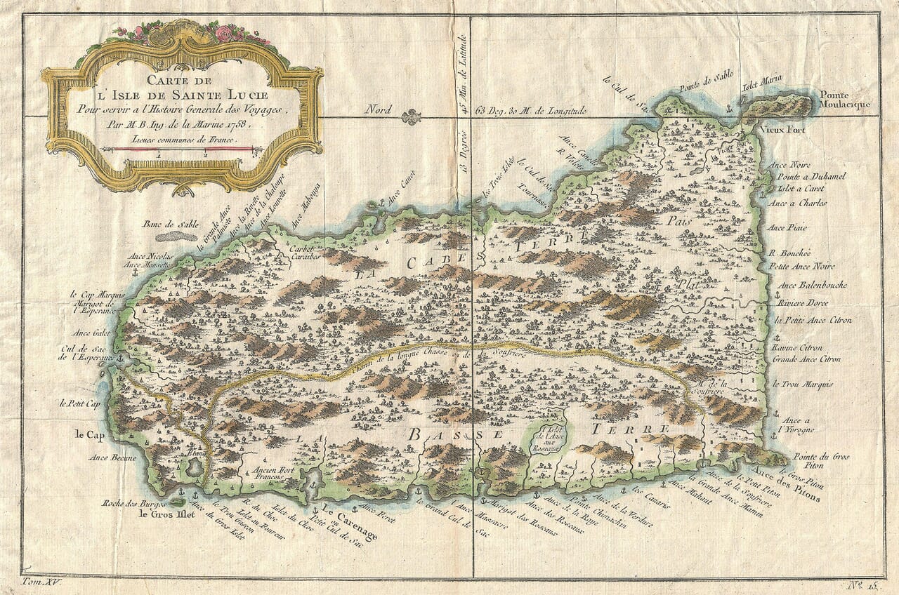
This finely detailed old map of Saint Lucia was created by the French hydrographer Jacques-Nicolas Bellin and published in Paris in 1758. It depicts the Caribbean island’s mountainous interior, wooded landscape, bays and anchorages, with delicate period colouring and an ornate rococo title cartouche.
Bellin’s engraving preserves Saint Lucia as it was understood during a century of intense French and British rivalry in the West Indies. Familiar locations include Vieux Fort, Gros Islet, Soufrière and the coastal area later associated with Castries.
A stunning certified FINE ART PRINT on heavy textured art paper — not a poster
Unlike most online offerings, our maps are produced entirely in-house, not outsourced to print-on-demand or drop-shipping services. This allows complete control over quality while offering better value. Each map begins with a high-resolution original, carefully enhanced and printed to order using archival papers and pigment inks for exceptional clarity, depth, and longevity. Every piece is personally overseen — no map leaves our workshop unless it is of a quality we would be proud to display ourselves.
Paper choice is essential to the authenticity of our maps. We use specially sourced 190gsm paper made in the UK from pure materials and traditionally pressed with natural woollen felts. This process creates a subtle, randomly textured surface that closely resembles an original antique document. Likewise the use of premium quality ink fully saturates the paper, producing remarkable clarity, depth, and historical character. Colour fastness and sharpness will remain good for in excess of 100 years!
The Old Map Company of Great Britain offers a vast and carefully curated collection of the very finest expertly reproduced vintage maps. Our range includes works by renowned cartographers such as John Speed and Willem Blaeu, covering Scotland, England, and beyond. Free UK courier delivery is included, with EU, USA, and worldwide shipping available at cost and calculated at checkout. If you need assistance, our team is always happy to help you choose the perfect map.
Speedy delivery A beautiful representation
Got there in time and loves it! Cheers David [Gift from US to UK]
Thanks Lauren. We received it today - it's gorgeous! Thank you, Ellan
Thank you for your prompt service. I have a gallery and framing business in South Wales. I'm so pleased it is printed in the UK
My Isles of Scilly map arrived safely and I'm delighted with it!
The print arrived safely and we're delighted with it - a lovely reminder of our honeymoon 15 years ago.
I have just received them! I'm sure our clients will be pleased with them and there could be more projects off the back of this one where we can use more. [Interior Designers]
I just received my map of Ireland by Ewart today and, as usual, I am delighted by its quality. The crispness and fineness of detail is excellent and the colour reproduction surpasses my expectations. Please relay my thanks to Steve for another fine effort!
Many thanks, Lauren. Very pleased with the map and the service: would recommend The Old Map Company to anyone interested in Old Maps.
Many thanks, the map arrived safely this morning, and I’m really pleased with it. A stunning reproduction, just as I had hoped. I will keep browsing your website, and may yet be tempted by more of your items! Have a great weekend.
Just arrived, wonderful map! Thanks very much!
The map – beautiful – arrived safely, very many thanks.
Thank you, I have already found the map. It’s wonderfull! Good luck! Rasa
My apologies for the very late reply. I wanted to reach out to thank you so much for rushing my order. My partner absolutely loved it. I am amazed with the service so that is a five-star from me. I wish you all the best.
Bellin’s map appeared in 1758, while European powers were competing for control of the Caribbean and its strategically important sea routes. Saint Lucia occupied a valuable position among the Windward Islands, between Martinique and Saint Vincent. Its sheltered bays, fertile land and proximity to other French and British possessions made it important to both nations.
Map Details
Original title: Carte de l’Isle de Sainte Lucie
Cartographer: Jacques-Nicolas Bellin
Published: Paris, 1758
Original publication: Histoire générale des voyages
Region shown: Saint Lucia, Windward Islands, Caribbean
Orientation: East is shown at the top
Printing method: Copperplate engraving
The map was produced for the influential Histoire générale des voyages, a major French collection of travel accounts edited by Abbé Prévost. Its purpose is stated within the cartouche: Pour servir à l’Histoire Générale des Voyages. Bellin’s maps enabled European readers to follow descriptions of distant countries, islands and voyages with a geographical image before them.
Rather than using modern contour lines, Bellin represented Saint Lucia’s relief through clusters of individually engraved hills and mountains. The island is divided into La Basse Terre and La Cabes Terre, names reflecting the French geographical understanding of the island at the time.
Numerous rivers descend from the mountainous interior towards the coast. Wooded and cultivated areas are distinguished with tiny engraved trees and other symbols, giving the map a remarkably textured appearance despite its relatively small original size.
The coastline carries an abundance of French place names. Among those visible are Vieux Fort, Gros Islet, Soufrière, Anse des Pitons, Cul de Sac and Le Carenage. Small anchor symbols identify recognised places of shelter for ships, while rocks, sandy banks and exposed headlands warn of potential navigational dangers.
One particularly interesting name is Le Carenage, shown on the north-western coast. A carenage was a sheltered harbour where wooden ships could be careened for cleaning and repairs. The name was later transferred to the settlement that became Saint Lucia’s capital and was renamed Castries in 1785. Saint Lucia’s government records specifically confirm that both the 1758 and 1763 maps marked Le Carenage.
The survival of so many French place names is part of the island’s distinctive history. Castries, Soufrière, Gros Islet and Vieux Fort remain familiar names today, connecting the modern country directly with the landscape recorded by Bellin.
Jacques-Nicolas Bellin was one of the foremost French mapmakers of the eighteenth century. As an engineer and hydrographer attached to the French naval chart office, he compiled maps from navigational reports, earlier surveys and accounts supplied by mariners.
His Saint Lucia map combines practical coastal information with the decorative character expected by readers of a prestigious travel collection. The elaborate cartouche, crowned with flowers and curling ornament, contrasts beautifully with the close engraving of the island below.
Published during a period of rivalry between France and Britain, the map predates the British occupation of Saint Lucia in 1762 and its restoration to France under the Treaty of Paris in 1763. It therefore captures the island at an especially significant point in its colonial history.