Belize When It Was British Honduras
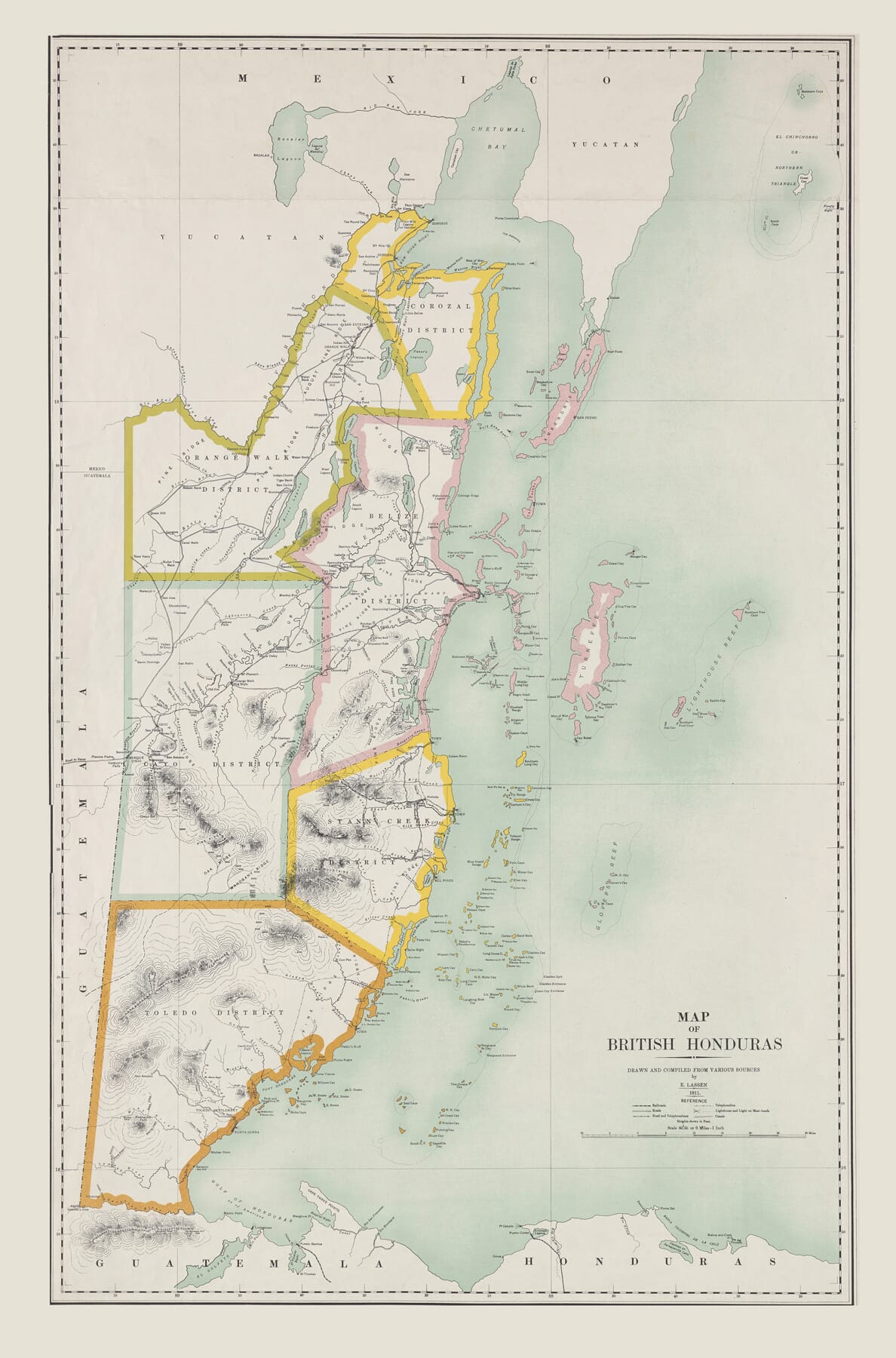
Drawn and compiled by E. Lassen in 1911, this map records present-day Belize under its former colonial name of British Honduras. The dated cartographic work was subsequently published by the Ordnance Survey Office in Southampton in 1912, at a scale of 1:380,160.
Map Details
Original title: Map of British Honduras
Cartographer and compiler: E. Lassen
Map date: 1911
Publication date: 1912
Publisher: Ordnance Survey Office
Place of publication: Southampton
Scale: 1:380,160
Present-day country: Belize
Historic name: British Honduras
Districts shown: Corozal, Orange Walk, Belize, Cayo, Stann Creek and Toledo
Neighbouring territories: Mexico and Guatemala, with Honduras shown across the Gulf
Principal settlements: Belize, Corozal, Orange Walk, Stann Creek and Punta Gorda
Notable physical features: Belize River, New River, Sibun River, Hondo River, Sarstoon River, Cockscomb Mountains and Pine Ridge
Offshore features: Ambergris Caye, Turneffe Islands and numerous smaller cays, reefs, shoals and channels
Map features: District boundaries, settlements, roads, tracks, rivers, lagoons, inland relief, coastal soundings and offshore islands
The name British Honduras had only acquired formal colonial status in 1862. British settlement in the region was much older, having developed around timber cutting along the Caribbean coast. The map therefore represents a territory with centuries of history but a comparatively recent administrative identity.
Its long, narrow shape follows the Caribbean shoreline from the Hondo River and Mexico in the north to the Sarstoon River in the south. Guatemala occupies the western side of the sheet, while the pale blue sea opens eastwards towards the cays and reef.
Six Historic Districts
The coloured boundaries divide British Honduras into six administrative districts: Corozal, Orange Walk, Belize, Cayo, Stann Creek and Toledo. All six names remain in use as the districts of modern Belize, although their boundaries and patterns of settlement have changed.
Corozal and Orange Walk occupy the north, close to Mexico and the Yucatán Peninsula. The Belize District surrounds the colonial capital and the mouth of the Belize River. Cayo extends inland towards Guatemala, while Stann Creek and Toledo cover the central and southern coasts.
The strength of the coloured boundary lines is particularly revealing. They present the colony as a clearly organised territory, even where the mapped interior remained thinly settled and incompletely surveyed. Large areas contain rivers, hills and scattered place names but few roads.
Belize itself appears on the coast rather than at the geographical centre of the territory. Its position reflects the settlement’s maritime origins and its importance as the principal port through which timber and other goods were exported.
Rivers as Routes into the Interior
The river system dominates much of the map. The Hondo forms the northern boundary, while the New River, Belize River, Sibun, Stann Creek, Monkey River and Sarstoon connect the wooded interior with the coast.
Before an extensive road network existed, these waterways provided essential routes for people, supplies and timber. Rivers allowed workers to penetrate the forests and offered a means of floating cut timber towards the coast for shipment.
The winding courses and numerous tributaries explain why the map devotes so much attention to waterways. They were not simply physical features: they were central to communication and to the economic life of British Honduras.
The Belize River was particularly important. It led from the interior towards Belize Town, now Belize City, and connected the principal port with districts where mahogany and other forest resources were obtained.
Logwood, Mahogany and the Colonial Economy
British interest in the region began with logwood. The tree produced a valuable dye used by the European textile industry, and British cutters established camps along the rivers and coastal lagoons while Spain continued to claim sovereignty over the territory.
Mahogany later became the more important export. The size and weight of the trees made extraction difficult, requiring organised labour, access to rivers and considerable knowledge of the forest.
This history lies quietly behind the map. Its dense network of rivers, named creeks and interior tracks records the landscape through which the timber economy operated. Settlement remained concentrated along waterways and the coast rather than spreading evenly across the country.
The industry also had a harsh human history. Enslaved Africans and their descendants provided much of the labour that sustained the early timber economy. Emancipation in the British colonies came during the 1830s, but ownership of land and commercial power remained highly unequal.
By 1911, mahogany continued to be significant, while chicle collected from sapodilla trees had become another valuable forest export. The map belongs to a period when the colony’s economy still depended heavily upon its forests and access to overseas markets.
Mountains and an Incompletely Known Interior
The southern half of the map differs markedly from the flatter northern districts. Shaded relief indicates the rising ground of the Cockscomb Mountains and neighbouring ranges, while Pine Ridge is named within the interior.
These areas appear far less densely mapped than the coast. Roads and settlements are sparse, and some geographical information remained provisional. That contrast gives the map much of its character: administrative boundaries are boldly drawn, but the physical landscape within them was still being surveyed and described.
The mountain country, forest and broken terrain made travel difficult. This helps explain why rivers, trails and isolated settlements carry such importance on the sheet.
The map is not simply a finished statement of geographical knowledge. It also shows where knowledge was concentrated and where the colonial survey remained dependent upon earlier reports, expeditions and “various sources”, as the title’s attribution acknowledges.
The Barrier Reef and Offshore Cays
The treatment of the coast is one of the map’s most distinctive qualities. A long chain of reefs and islands runs parallel with the mainland, separated from it by shallow coastal water.
Ambergris Caye appears in the north near the entrance to Chetumal Bay. Farther south lie Turneffe and a profusion of smaller cays, channels and shoals. Their careful inclusion reflects the importance—and difficulty—of navigation along this coast.
Belize forms part of the extensive Mesoamerican reef system. For sailors approaching the mainland, the reef offered both shelter and danger. Channels provided access to ports and anchorages, but reefs and shallow water demanded accurate local knowledge.
At reproduction size, not every tiny offshore name will be individually legible. Nevertheless, the extraordinary profusion of mapped cays and reefs remains clearly visible and gives the eastern side of the map its delicate, almost lace-like appearance.
From British Honduras to Belize
The country continued to be known officially as British Honduras for much of the twentieth century. The name was changed to Belize in 1973, and full independence followed in 1981.
For this reason, the title Map of British Honduras is an important part of the map’s historical identity. It places the work within a particular colonial period while depicting the recognisable outline, districts, rivers and coastal islands of modern Belize.
The map’s lasting appeal lies in this meeting of old and familiar names. Corozal, Orange Walk, Cayo, Stann Creek and Toledo remain part of Belizean geography, but Lassen’s map shows them within a landscape where rivers were major thoroughfares, the forest shaped the economy and large portions of the interior remained difficult to reach.





 Verified owner