Robert Gordon’s Map of Aberdeenshire and Banffshire
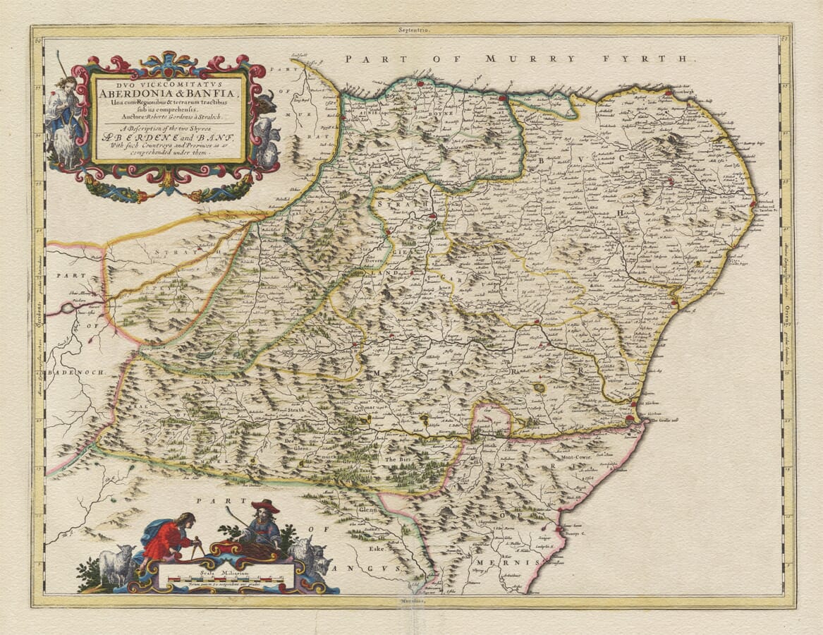
This historic map of Aberdeenshire and Banffshire was drawn by Robert Gordon of Straloch and published by Joan Blaeu in Amsterdam in 1654. Its Latin title is Duo Vicecomitatus Aberdonia & Banfia, una cum Regionibus & terrarum tractibus sub iis comprehensis. Beneath it appears the English title, A Description of the two Shyres Aberdene and Banf, With such Countreys and Provinces as ar comprehended under them.
Map Details
- Original title: Duo Vicecomitatus Aberdonia & Banfia
- Cartographer: Robert Gordon of Straloch
- Publisher: Joan Blaeu
- First published: Amsterdam, 1654
- Area shown: Aberdeenshire, Banffshire and adjoining districts of northeast Scotland
- Visible details: Buchan, Strathbogie, the rivers Don and Dee, pastoral figures and livestock
- Source publication: Blaeu’s Scotland atlas, Theatrum Orbis Terrarum, sive Atlas Novus
The wording reflects the map’s generous coverage. It includes not only the historic shires of Aberdeen and Banff but also adjoining districts and traditional territories extending from the Moray Firth and Buchan coast into the mountain country of Mar, Braemar and Strathspey.
Robert Gordon of Straloch
Unlike many maps in Blaeu’s atlas of Scotland, this plate was not copied directly from a surviving survey by Timothy Pont. It was one of eleven maps newly prepared by Robert Gordon of Straloch to complete and improve the collection.
Born in Aberdeenshire in 1580, Gordon was a landowner, scholar, antiquary and accomplished mapmaker with an intimate knowledge of northeast Scotland. He had been asked to revise Pont’s surviving geographical material and prepare it for publication. Where important areas remained incomplete, Gordon supplied maps of his own.
His authorship is acknowledged prominently within the title cartouche by the words Auctore Roberto Gordonio à Straloch—“by Robert Gordon of Straloch.” Joan Blaeu’s Amsterdam workshop then engraved and printed the finished design for the Scottish volume of the Theatrum Orbis Terrarum, sive Atlas Novus in 1654.
The result brought Scottish fieldwork and local knowledge together with the engraving and printing skills of the Dutch Golden Age. Blaeu’s publication was the first printed atlas devoted to Scotland and presented the country in greater regional detail than had previously been available to European readers.
From the Moray Firth to Aberdeen
The northern coastline runs from the country bordering Moray eastwards past the mouth of the River Spey and onwards towards Banff. The coast then sweeps around the great northeastern shoulder of Scotland through Fraserburgh and Peterhead before turning south towards Aberdeen.
Banff appears beside the River Deveron, surrounded by the lands of Boyne and the Enzie. Farther east, the extensive district of Buchan occupies much of the landscape between Banff and the North Sea. Its numerous settlements reveal that the northeast was far from the empty country sometimes imagined by distant seventeenth-century readers.
Aberdeen stands near the mouths of the rivers Don and Dee. The map distinguishes between Old Aberdeen and New Aberdeen, reflecting the two communities that existed before their formal union in the nineteenth century. Old Aberdeen had grown around St Machar’s Cathedral and King’s College, while the commercial burgh of New Aberdeen developed around its harbour and market.
The coastline also records smaller fishing communities, river mouths and headlands. To sailors, merchants and fishermen, these waters were both a source of livelihood and a route connecting Scotland’s northeast with the Low Countries, Scandinavia and ports around the North Sea.
Rivers, Glens and Highland Country
Moving inland, the map follows the Dee and Don towards their mountain sources. The valleys of these rivers provide natural pathways into the Highlands, drawing the eye westwards from the cultivated coastal country towards Mar, Braemar and the high ground adjoining Badenoch.
The River Ythan crosses the central lowlands, while the Deveron winds northwards through Strathbogie towards Banff. Settlements, castles and estates cluster along these waterways, demonstrating their importance for travel, farming and local authority.
Buchan, Formartine, Garioch, Strathbogie, Mar and Braemar appear as recognisable regional names. These older divisions often carried strong associations with lordship, clan connections and the natural geography of the land. Their boundaries do not correspond precisely with those of later counties or modern local authorities.
Mountain ranges are represented through rows of shaded pictorial hills rather than measured contours. Woodland is shown by small groups of trees, while towns, kirks, castles and houses are indicated with conventional building symbols. Roads are not systematically depicted, and distances should be understood as approximate.
Yet the density of names is remarkable. For anyone tracing a family or a familiar corner of northeast Scotland, the map invites slow exploration as old spellings, forgotten estates and small communities gradually reveal themselves.
Life in Seventeenth-Century Northeast Scotland
When Gordon prepared this map, Aberdeen was an important university city, royal burgh and trading port. Its merchants maintained connections across the North Sea, while the surrounding countryside supported farming, cattle raising, fishing and local markets.
Beyond the burghs lay a landscape of estates, castles, kirks and small agricultural communities. Coastal fishing was particularly important, while the fertile lower valleys contrasted with the more rugged uplands of Mar and Braemar.
The map appeared shortly after Scotland had endured years of political and military conflict during the Wars of the Three Kingdoms. Gordon and Blaeu did not attempt to portray these disturbances. Their map instead presents an enduring picture of the region’s rivers, settlements and territories.
Pastoral Decoration
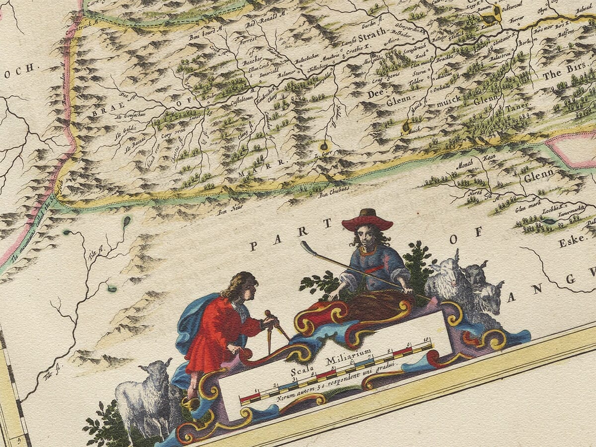
The title cartouche is accompanied by a shepherd with sheep and goats. At the foot of the map, further rural figures attend the scale, one using dividers to connect the pastoral landscape with the careful measurement involved in cartography.
These decorative scenes give the engraving warmth without overwhelming its exceptional geographical detail. More than three and a half centuries later, this antique map remains a deeply engaging portrait of Aberdeenshire and Banffshire—stretching from the North Sea coast to the rivers, glens and mountain country at the heart of northeast Scotland.






 Verified owner














