Joan Blaeu’s Map of Historic Westmorland
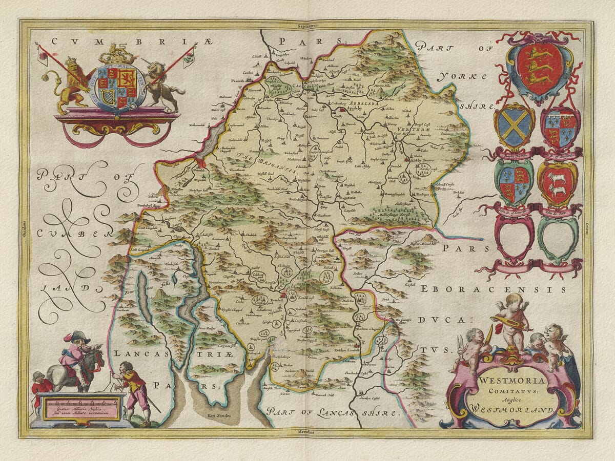
Joan Blaeu’s map of Westmorland was first published in Amsterdam in 1645 as part of the fourth volume of his Theatrum Orbis Terrarum, sive Atlas Novus. This volume presented a comprehensive collection of English and Welsh county maps in the decorative style associated with the Blaeu workshop.
The engraved title, Westmoria Comitatus; Anglice Westmorland, may be understood as “The County of Westmorland, in English Westmorland.” It confirms the historic spelling without the additional “e” frequently found in later usage.
Although the existing product page attributes the map to William Blaeu, William had died in 1638. The Westmorland plate was produced during the period when his son Joan directed and expanded the family publishing house and should therefore be attributed to Joan Blaeu.
Blaeu’s Sources and Later Editions
Blaeu did not personally survey Westmorland. The map’s geography was based principally upon earlier English county mapping, particularly John Speed’s map and the surveying tradition established by Christopher Saxton.
Blaeu’s engravers refined this inherited geographical information and surrounded it with ornamental cartouches, heraldic devices and decorative figures. The result combined a practical record of settlements and natural features with the visual richness expected by buyers of an important seventeenth-century atlas.
For comparison, our old map of Westmorland by John Speed shows the earlier English interpretation upon which Blaeu’s map was largely based.
The copperplate continued to be used after its first appearance in 1645. Original examples may consequently carry Latin, French, Dutch, German or Spanish text on the reverse. The map was later included in Blaeu’s monumental Atlas Maior during the 1660s.
The Historic County
Westmorland was one of England’s smaller historic counties. It bordered Cumberland to the north and west, Yorkshire to the east and Lancashire to the south. Its territory is now largely included within Cumbria, but the name Westmorland retains a strong historical and geographical identity.
Appleby was traditionally the county town and appears prominently in the valley of the River Eden. Kendal was the county’s largest and most commercially important settlement, positioned on the River Kent in the south.
Other recognisable places include Ambleside, Kirkby Lonsdale, Brough, Orton, Shap and many smaller villages and estates. Historic spellings frequently differ from their modern forms, making the map particularly interesting for local and family-history research.
The map should not be interpreted as a modern measured survey. Settlements are represented through conventional church and building symbols, while the relative importance of places may be suggested by the size of those symbols. Roads are not systematically recorded, and relief is shown pictorially rather than through measured contours.
Mountains, Lakes and Rivers
The physical landscape dominates Blaeu’s depiction of Westmorland. Mountains and upland ridges are represented by densely arranged hill symbols, giving the county a strikingly rugged appearance.
Windermere is the most prominent lake and appears under a historic form of its name. The map also includes the eastern part of Ullswater and other lakes and waterways associated with the county’s upland landscape.
The River Eden flows northwards through the eastern side of Westmorland, passing close to Appleby. In the south, the River Kent runs through Kendal towards Morecambe Bay, while the Lune passes Kirkby Lonsdale before continuing into Lancashire.
These rivers were important to settlement, agriculture and local industry. They supplied water power for mills and connected communities through valleys that offered more practical routes across an otherwise difficult landscape.
Blaeu’s map predates the later idea of the Lake District as a celebrated destination for tourists, artists and writers. The improved roads, railways, hotels and organised tourism of the eighteenth and nineteenth centuries still lay far in the future. The lakes and mountains appear as elements of a working rural county rather than as visitor attractions.
Farming, Wool and Kendal Cloth
The economy of seventeenth-century Westmorland was shaped by its landscape. Much of the upland ground was better suited to livestock than intensive arable cultivation, making cattle and sheep important to rural life.
Wool supported local spinning, weaving and cloth production. Kendal became particularly associated with woollen textiles, including the hard-wearing cloth known as Kendal green. The town’s position between northern England, Lancashire and routes towards Yorkshire helped it develop as a regional market and manufacturing centre.
The map’s decorative figures and cloth imagery acknowledge these connections between the county’s landscape and its economy. They also provide a visual contrast with the precisely engraved place names, rivers and mountain symbols.
Cartouches and Heraldry
Blaeu’s map includes an ornamental title cartouche and a separate scale cartouche attended by decorative figures and putti. Surveying instruments refer to the craft of mapmaking, while other figures and objects evoke the county’s agricultural and textile economy.
The royal arms provide the principal heraldic feature. Six additional armorial positions appear on the map, including two blank shields. Such blank shields are found on several maps in Blaeu’s English county series and indicate spaces where the intended arms were never engraved.
Original maps were printed from the copperplate in black ink, with colour subsequently added to selected impressions. The combination of pictorial mountains, historic settlements, heraldry and ornamental engraving makes this one of the most attractive early maps of Westmorland.
It preserves the county before modern transport, tourism and administrative reorganisation transformed the region, offering both a historic county map and an evocative portrait of the landscape now associated with Cumbria and the Lake District.





 Verified owner