Historical Background
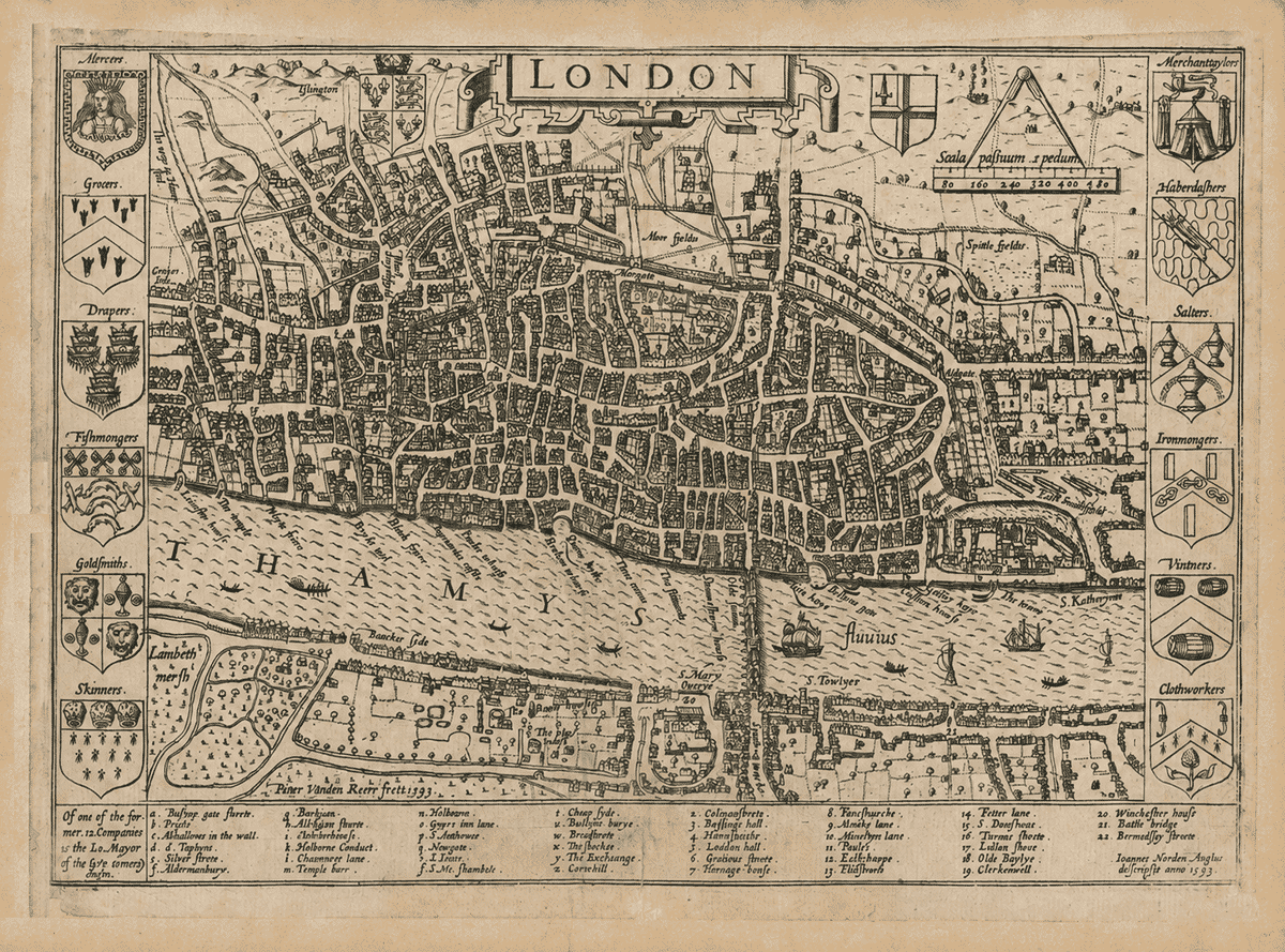
Surveyed by John Norden and engraved by Pieter van den Keere in 1593.
This old Tudor London map was published during the final decade of Elizabeth I’s reign as part of John Norden’s Speculum Britanniae, an ambitious survey and description of Britain. The first published section covered Middlesex and included Norden’s plans of London and Westminster.
Map Details
- Original title: London
- Surveyor and cartographer: John Norden
- Engraver: Pieter van den Keere
- Published: London, 1593
- Source publication: Speculum Britanniae: The First Parte
- Area shown: London, Islington, East Smithfield, Southwark and Gray’s Inn
- Orientation: North approximately towards the top
- Printing method: Copperplate engraving
- Border decoration: Arms of twelve London Great Livery Companies
- Notable features: London Bridge, Old St Paul’s Cathedral, the Tower of London, the Thames and the open fields surrounding the city
The map presents London from an elevated viewpoint, combining a recognisable street plan with individual buildings, churches, gardens and walls. At the bottom, Norden identifies himself in Latin as the English surveyor, while Van den Keere’s inscription records his work as the engraver in 1593.
The River Thames, labelled Thamesis fluvius, dominates the lower half of the plan. Sailing vessels and smaller boats occupy the water, while London Bridge crosses the river carrying the houses and shops that once lined its roadway.
North of the Thames, the built city is densely packed within and around its walls. Old St Paul’s Cathedral rises among the surrounding churches, while the Tower of London forms a clearly defined fortified complex at the eastern edge.
Beyond the crowded streets are gardens, fields and semi-rural settlements. Moorfields and Spitalfields remain largely open, while Islington appears as a separate settlement reached by roads leading north from the city.
Southwark is much less densely developed. The map shows houses along the river and roads, together with Lambeth Marsh, Paris Garden and a playhouse—features associated with the entertainments that flourished outside the jurisdiction of the City authorities.
The heraldic borders display the arms of twelve Great Livery Companies, including the Mercers, Grocers, Drapers, Fishmongers, Goldsmiths, Skinners, Merchant Taylors, Haberdashers, Salters, Ironmongers, Vintners and Clothworkers.
A numbered reference key identifies important gates, streets, churches and civic buildings. These details make the map a valuable record of Elizabethan London at the time of Shakespeare, before the city’s seventeenth-century expansion and the destruction caused by the Great Fire of 1666.
John Norden’s London: the Capital at the End of the Tudor Age
John Norden’s map presents London in 1593, during the closing decade of Elizabeth I’s reign. It was first published as part of Speculum Britanniae: The First Parte, an Historical & Chorographical Description of Middlesex, Norden’s ambitious attempt to survey and describe Britain county by county. The project was never completed, but its surviving maps established Norden as one of the most observant English surveyors and cartographers of his generation.
The engraving was cut by Pieter van den Keere, a Flemish-born engraver whose fine line made him particularly well suited to Norden’s densely detailed design. At an approximate scale of 1:15,840, the map combines a ground plan with a bird’s-eye view: streets and open ground are arranged cartographically, while houses, churches, gates, ships and trees are drawn pictorially. It is not a modern measured street plan, yet it conveys the form and character of late-sixteenth-century London with extraordinary immediacy.
The walled City occupies the centre of the composition. Its streets are packed tightly around the great bulk of old St Paul’s Cathedral, whose medieval spire had been destroyed by lightning in 1561. The city gates still control the principal approaches, including Bishopsgate, Aldersgate and Newgate. Beyond them, development thins rapidly into gardens, fields and roadside settlements. To the north are Moorfields and Spitalfields; to the west, Holborn stretches towards the Inns of Court; and outside the walls stand the Charterhouse and the former priory of St John at Clerkenwell.
The Thames dominates the lower half of the map. It was London’s principal highway, busy with wherries, sailing vessels and commercial traffic. Wharves, stairs and warehouses line the northern bank, while the bridge is the sole permanent road crossing shown. London Bridge was itself a neighbourhood, carrying houses, shops and a chapel above its crowded arches. South of the river, Southwark developed along the roads leading from the bridge. Winchester Palace, the residence of the powerful bishops of Winchester, appears close to the waterfront, while the open Bankside landscape includes the playhouse and bear-baiting enclosures that helped make the area famous.
This was the London known by Shakespeare at the beginning of his theatrical career. The Globe had not yet been built—it opened in 1599—but playhouses, inns, taverns and animal-baiting arenas were already attracting audiences beyond the City’s direct control. The map also belongs to a difficult year: a severe outbreak of plague affected London in 1592–93, closing the public theatres and exposing the vulnerability of a fast-growing capital whose population, housing and trade were pressing beyond its medieval boundaries.
Norden’s design is also a portrait of civic power. Down its sides appear the arms of the twelve Great Livery Companies: the Mercers, Grocers, Drapers, Fishmongers, Goldsmiths, Skinners, Merchant Taylors, Haberdashers, Salters, Ironmongers, Vintners and Clothworkers. Their members dominated London’s commercial life and supplied many of its mayors and aldermen. The royal arms and the arms of the City stand prominently above the plan, placing London within both royal government and its own long-established civic traditions.
The reference key running along the foot transforms the engraving from a decorative view into a practical guide. Letters and numbers identify important streets, churches, markets, gates, conduits and great houses. Some names—Fleet Street, Cornhill, Chancery Lane and Fenchurch Street—remain familiar. Others, including Papey, St Taphyns, the Stocks and St Nicholas Shambles, belong to a city later reshaped by the Great Fire of 1666, rebuilding, railways, wartime destruction and modern development.
Later impressions of Norden’s map appeared in 1623 and 1653, evidence of its continuing usefulness and appeal. Today it offers something more: a compact but richly detailed window into London before the Great Fire, when the medieval city, the Tudor court, international trade and the emerging world of Shakespearean theatre existed side by side.
Reading the Original Reference Key
Norden placed a practical gazetteer along the foot of the map. The first group of locations is identified by letters, beginning with a, b and c and continuing to z. In accordance with early modern alphabet conventions, the letters j and v are omitted. A second group is identified by numbers running from 2 to 22; no numbered entry 1 appears in the surviving printed key. The original spellings are reproduced below as closely as possible, followed by their modern identifications and brief historical notes.
Lettered Places
a. Byshops gate streete — Bishopsgate
The great north–south road passing through Bishopsgate, one of the principal gates in London’s wall. The modern street follows substantially the same historic route.
b. Papie — St Augustine Papey
A former parish church and charitable community near Bishopsgate and the City wall. “Papey” became associated with accommodation and support for elderly or impoverished priests.
c. Alhallowes in the wall — All Hallows-on-the-Wall
A medieval church built against the northern City wall. Its position outside the most densely burned area helped it escape the Great Fire, although the present church is largely eighteenth-century.
d. S. Taphyns — St Alphage, London Wall
“St Taphyns” was an early variant name for St Alphage. The church stood beside the wall near Cripplegate; fragments of its later fabric survive within the modern Barbican area.
e. Syluer streete — Silver Street
A narrow medieval street near London Wall and Wood Street. Shakespeare lodged here with the Mountjoy family in the early seventeenth century; the street disappeared following wartime destruction and redevelopment.
f. Aldermanburye — Aldermanbury
An old City street close to Guildhall, traditionally associated with the aldermen and civic administration. Its name and part of its historic line survive today.
g. Barbican — the Barbican
The name derives from an outer defensive work or fortified watchtower on the City’s northern side. Norden shows the still semi-rural district centuries before the modern Barbican Estate.
h. Aldersgate streete — Aldersgate Street
The road running north from Aldersgate, the City gate that gave access towards Clerkenwell and St Albans. The street remains an important route beside the Barbican.
i. Charterhowse — the Charterhouse
Founded as a Carthusian monastery beside a plague burial ground, the Charterhouse was dissolved under Henry VIII and converted into a great mansion. Its surviving buildings later became a school and almshouse.
k. Holborne Conduit — Holborn Conduit
A public water conduit near Holborn Cross. Such conduits brought fresh water through pipes to accessible points and were essential pieces of civic infrastructure in Tudor London.
l. Chauncery lane — Chancery Lane
The old route between Fleet Street and Holborn. By Norden’s time it was firmly associated with legal institutions, records and the nearby Inns of Court.
m. Temple barr — Temple Bar
The ceremonial western boundary between the City and Westminster, standing near the Temple. Norden’s bar preceded Christopher Wren’s famous seventeenth-century stone gateway.
n. Holbourn — Holborn
A major western approach to the City, descending towards the valley of the River Fleet. Its ribbon of houses shows London already expanding well beyond the medieval walls.
o. Grayes Inn lane — Gray’s Inn Lane
The road leading north beside Gray’s Inn, one of the four Inns of Court. Much of it is now known as Gray’s Inn Road.
p. S. Andrewes — St Andrew Holborn
The medieval parish church at the western edge of the City. Damaged in the Great Fire, it was substantially rebuilt under Christopher Wren and remains on Holborn Viaduct.
q. Newgate — Newgate
One of London’s principal western gates and also the site of the notorious Newgate Prison. The gate controlled the route towards Holborn and the west.
r. S. Iones — St John’s Priory, Clerkenwell
The former priory of the Knights Hospitaller, also called St John of Jerusalem. Although dissolved under Henry VIII, parts of the precinct survived; its remarkable Tudor gatehouse still stands.
s. S. Nic shambels — St Nicholas Shambles
A parish church within the butchers’ quarter near Newgate. “Shambles” referred to meat stalls and slaughtering; the church was destroyed in the Great Fire and not rebuilt.
t. Cheap syde — Cheapside
London’s great market street. Its name comes from the Old English word for buying and selling, and its specialised side streets served many different trades.
u. Bucklers burye — Bucklersbury
A busy street near the Walbrook, particularly associated with grocers, apothecaries, herbs and spices. Much of its old course was lost through later rebuilding.
w. Brode streete — Broad Street
A broad commercial street and the centre of its own City ward. Its name survives chiefly in Old Broad Street within London’s modern financial district.
x. The Stockes — the Stocks Market
A central market for fish and meat near the junction of Cornhill, Poultry and Walbrook. The market was removed in the eighteenth century and the Mansion House was built on its site.
y. The Exchange — the Royal Exchange
Sir Thomas Gresham’s purpose-built merchants’ exchange, opened in 1568 and given the title “Royal Exchange” by Elizabeth I in 1571. It symbolised London’s growing international commerce.
z. Cornehill — Cornhill
One of the City’s oldest principal streets, traditionally associated with the grain trade. It linked Leadenhall and the eastern approaches with the commercial centre around the Exchange.
Numbered Places
- Colman streete — Coleman Street
An old street running north from the commercial heart of the City towards the wall. The street and the name of Coleman Street Ward both survive.
- Bassings hall — Basinghall Street
A historic street leading towards Guildhall and several company halls. Its name is generally connected with the medieval Basing family, who held property in this part of the City.
- Honnsditche — Houndsditch
The road followed the outside of the eastern City wall. Its memorable name was linked by early writers to the dumping of refuse—and supposedly dead dogs—in the old defensive ditch.
- Leaden hall — Leadenhall
A great market building and trading centre in the eastern City, used particularly for food and provisions. The celebrated Victorian Leadenhall Market occupies the same historic market district.
- Gratious streete — Gracechurch Street
A principal route between London Bridge and Bishopsgate, passing through a busy market area. “Gracious Street” was one of several early forms of the modern name.
- Heneage house — Heneage House
A substantial residence near the lane leading to Bevis Marks, named after the influential Elizabethan courtier Sir Thomas Heneage. It represents the aristocratic houses embedded within the commercial City.
- Fancshurche — Fenchurch Street
An important east–west street in the City’s eastern wards. Its name survives, although the area was repeatedly transformed after the Great Fire and by later commercial building.
- Marke lane — Mark Lane
A narrow street running south towards Great Tower Street. It later became especially associated with London’s corn trade and the Corn Exchange.
- Minchyn lane — Mincing Lane
A long-established lane in the eastern City, close to merchants, warehouses and the river trade. Its present spelling disguises several medieval and Tudor forms of the name.
- Paules — old St Paul’s Cathedral
The vast medieval cathedral dominated London’s skyline and civic life. Its spire had already been lost in 1561; the remaining building was destroyed in the Great Fire and replaced by Wren’s cathedral.
- Eastcheape — Eastcheap
A market street near London Bridge, noted for butchers, cooks, taverns and food sellers. It formed part of the busy route carrying travellers from the bridge into the City.
- Fleetstreete — Fleet Street
The western road running beside and beyond the River Fleet towards Temple Bar. Long before its newspaper associations, it was linked with law, inns, taverns and printing.
- Fetter lane — Fetter Lane
An old lane connecting Fleet Street with Holborn. Its position near the Inns of Court later encouraged a strong association with lawyers, printers and publishers.
- S. Dunshous — St Dunstan-in-the-West
The medieval church on Fleet Street, serving a parish closely connected with the legal quarter. It survived the Great Fire but was replaced by the present nineteenth-century building.
- Themes streete — Thames Street
The crowded waterfront street serving wharves, warehouses, merchants and river stairs. Sections survive as Upper and Lower Thames Street, though the historic riverside has been greatly altered.
- Lodon Stone — London Stone
An ancient landmark now kept on Cannon Street. Its original purpose is uncertain, but for centuries it served as a recognised point of reference and accumulated numerous legends about London’s origins.
- Olde Baylye — Old Bailey
The street beside the western line of London’s wall and fortified bailey. Its later association with Newgate Prison led to the name becoming synonymous with the Central Criminal Court.
- Clerkenwell — Clerkenwell
A settlement beyond the northern wall, named after the Clerks’ Well where parish clerks traditionally performed plays. The district also contained important religious houses and gardens.
- Winchester house — Winchester Palace
The London residence of the bishops of Winchester in Southwark, within their privileged liberty. The surviving thirteenth-century great-hall wall and rose window remain visible near Borough Market.
- Battle bridge — Battle Bridge, Tooley Street
A bridge linking the St Olave’s and Tooley Street area with the road towards Bermondsey and Horsleydown. It was named for the abbots of Battle Abbey, who owned nearby property and maintained the crossing.
- Bermondsoy streete — Bermondsey Street
The road running south from Tooley Street towards Bermondsey Abbey. Its historic alignment and name survive, although the monastic landscape shown beyond it has long disappeared.
The Twelve Great Livery Companies
The heraldic shields down the sides represent the Mercers, Grocers, Drapers, Fishmongers, Goldsmiths and Skinners on the left, with the Merchant Taylors, Haberdashers, Salters, Ironmongers, Vintners and Clothworkers on the right. These were London’s wealthiest and most influential trading companies. Their inclusion was not merely decorative: the accompanying inscription notes that the Lord Mayor was commonly chosen from among the leading twelve companies.





 Verified owner












