



£35.55 – £59.95Price range: £35.55 through £59.95
Old Map of Rotterdam by Joan Blaeu, 1649
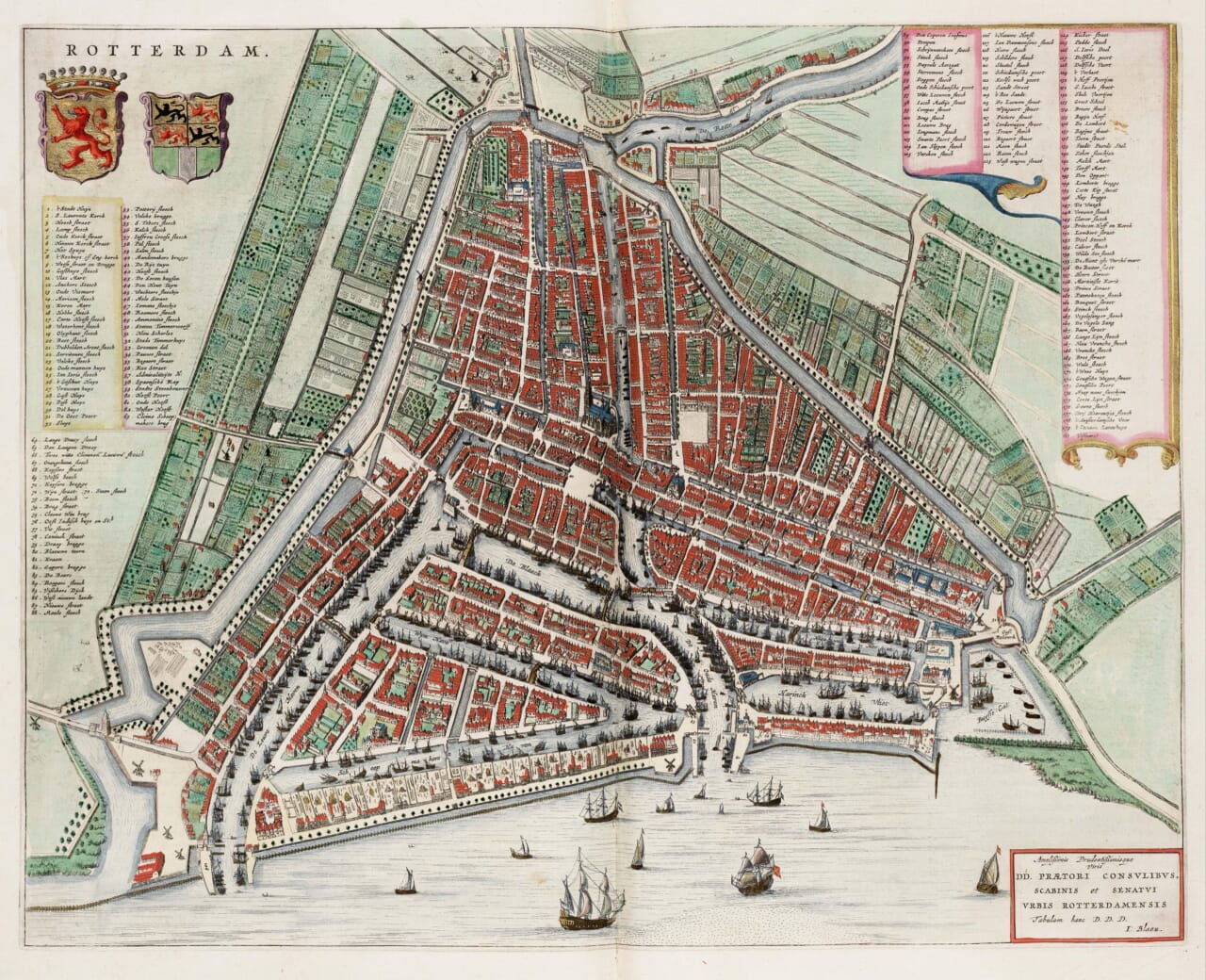
This richly detailed bird’s-eye plan presents Rotterdam as a thriving seventeenth-century port, with its streets, canals, harbour basins, fortifications and surrounding gardens carefully drawn. Ships crowd the waterways and the River Maas, while numbered keys identify an extraordinary range of streets, civic buildings, gates and other features across the city.A stunning certified FINE ART PRINT on heavy textured art paper — not a poster
Unlike most online offerings, our maps are produced entirely in-house, not outsourced to print-on-demand or drop-shipping services. This allows complete control over quality while offering better value. Each map begins with a high-resolution original, carefully enhanced and printed to order using archival papers and pigment inks for exceptional clarity, depth, and longevity. Every piece is personally overseen — no map leaves our workshop unless it is of a quality we would be proud to display ourselves.
Paper choice is essential to the authenticity of our maps. We use specially sourced 190gsm paper made in the UK from pure materials and traditionally pressed with natural woollen felts. This process creates a subtle, randomly textured surface that closely resembles an original antique document. Likewise the use of premium quality ink fully saturates the paper, producing remarkable clarity, depth, and historical character. Colour fastness and sharpness will remain good for in excess of 100 years!
The Old Map Company of Great Britain offers a vast and carefully curated collection of the very finest expertly reproduced vintage maps. Our range includes works by renowned cartographers such as John Speed and Willem Blaeu, covering Scotland, England, and beyond. Free UK courier delivery is included, with EU, USA, and worldwide shipping available at cost and calculated at checkout. If you need assistance, our team is always happy to help you choose the perfect map.
Speedy delivery A beautiful representation
Got there in time and loves it! Cheers David [Gift from US to UK]
Thanks Lauren. We received it today - it's gorgeous! Thank you, Ellan
Thank you for your prompt service. I have a gallery and framing business in South Wales. I'm so pleased it is printed in the UK
My Isles of Scilly map arrived safely and I'm delighted with it!
The print arrived safely and we're delighted with it - a lovely reminder of our honeymoon 15 years ago.
I have just received them! I'm sure our clients will be pleased with them and there could be more projects off the back of this one where we can use more. [Interior Designers]
I just received my map of Ireland by Ewart today and, as usual, I am delighted by its quality. The crispness and fineness of detail is excellent and the colour reproduction surpasses my expectations. Please relay my thanks to Steve for another fine effort!
Many thanks, Lauren. Very pleased with the map and the service: would recommend The Old Map Company to anyone interested in Old Maps.
Many thanks, the map arrived safely this morning, and I’m really pleased with it. A stunning reproduction, just as I had hoped. I will keep browsing your website, and may yet be tempted by more of your items! Have a great weekend.
Just arrived, wonderful map! Thanks very much!
The map – beautiful – arrived safely, very many thanks.
Thank you, I have already found the map. It’s wonderfull! Good luck! Rasa
My apologies for the very late reply. I wanted to reach out to thank you so much for rushing my order. My partner absolutely loved it. I am amazed with the service so that is a five-star from me. I wish you all the best.
Joan Blaeu’s plan of Rotterdam was first published in Amsterdam in 1649 as part of his celebrated town atlas of the Netherlands. It records the city at a particularly significant moment, only a year after the Peace of Münster formally recognised the independence of the Dutch Republic. Rotterdam was already developing rapidly as a centre of maritime trade, and Blaeu’s detailed plan celebrates both the order of the city and its intimate relationship with the water.
Map Details
A City Shaped by Water
The old town occupies the centre of the map, enclosed by canals and defensive works. The River Maas stretches across the lower edge, while waterways penetrate deeply into the built-up area and form sheltered harbours lined with houses, warehouses and quays. Numerous sailing vessels appear within the harbour basins and on the river, making Rotterdam’s commercial purpose immediately apparent.
The Rotte enters the city from the north, while the town’s streets and canals form a close, intricate pattern around the central market and civic buildings. Beyond the built-up centre, Blaeu depicts gardens, orchards, fields and long strips of cultivated land. This sharp division between the crowded port and the surrounding countryside shows how compact Rotterdam remained during the middle of the seventeenth century.
Streets, Gates and Landmarks
Numbered keys occupy both sides of the plan and identify well over a hundred locations. These include streets, bridges, gates, churches, markets, civic buildings and harbour features. Individual buildings are shown pictorially rather than simply represented as blocks, giving the map the character of an elevated view across the city.
The carefully drawn gateways and enclosing canals reveal the limits of seventeenth-century Rotterdam. Several windmills stand around the outskirts, where they could take advantage of unobstructed winds and remain clear of the densely built town.
Heraldry and Civic Pride
Beneath the large title at upper left are the arms of Holland and Rotterdam. At lower right, Joan Blaeu included a Latin dedication to Rotterdam’s governing burgomasters and council. These elements transformed the plan from a purely practical record into an expression of civic status.
This old map of Rotterdam is especially compelling because it combines precise urban information with the decorative qualities associated with Blaeu’s finest work. The coloured roofs, green gardens, heraldic decoration, busy harbour and extensive location keys preserve an exceptionally detailed picture of Rotterdam before the enormous expansion of the modern port.



