Abraham Ortelius’s 1570 map of Transylvania and present-day Romania
Abraham Ortelius’s 1570 map of Transylvania and present-day Romania Transilvania Map Burzenland

Old Map of Transylvania and Romania by Abraham Ortelius, 1570

Price range: £35.55 through £59.95

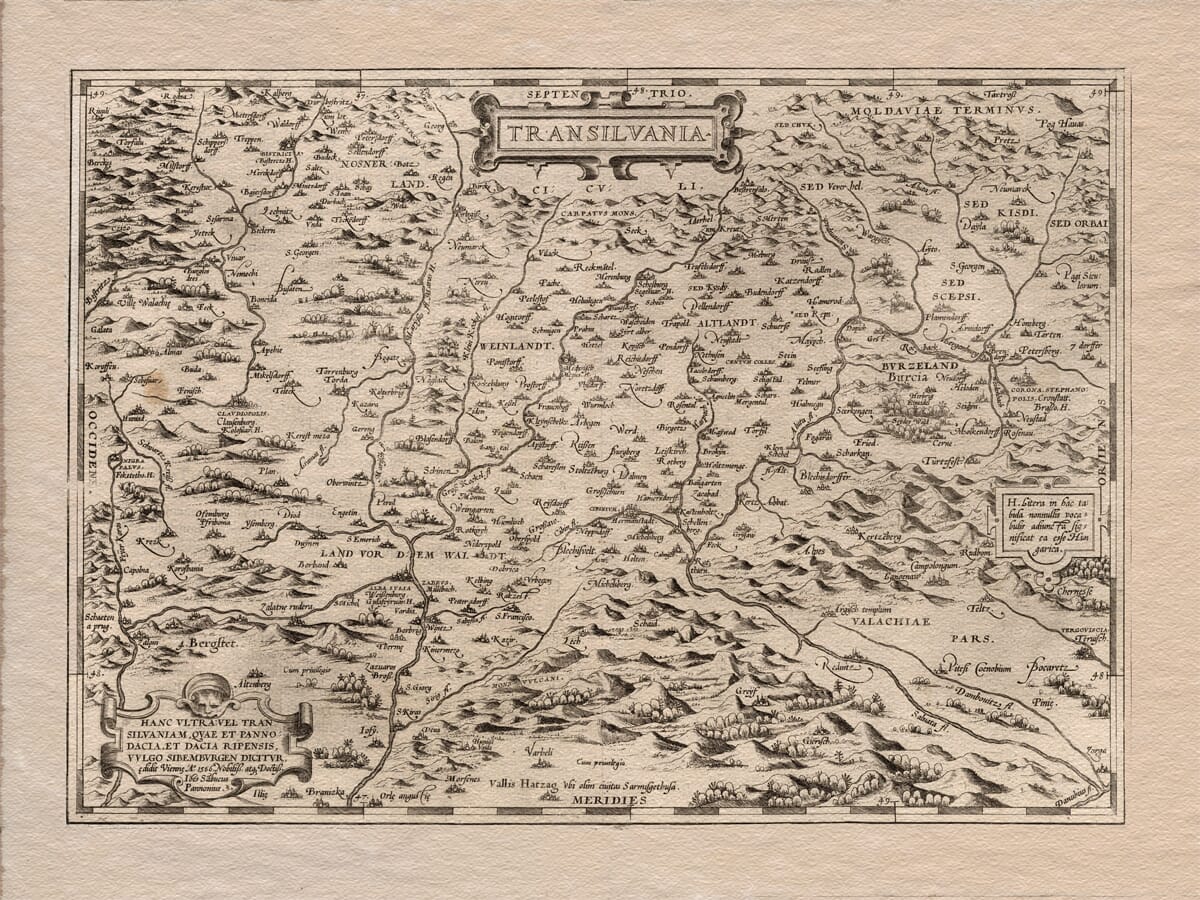
Old map of Transylvania in present-day Romania, first published by Abraham Ortelius in Antwerp in 1570.

Mountain chains, wooded valleys, rivers and fortified settlements fill this remarkable Renaissance map. Historic names include Clausenburg for Cluj-Napoca, Hermanstadt for Sibiu, Corona for Brașov and Bocaretz for Bucharest.

Ortelius’s engraving reaches beyond Transylvania into adjoining parts of Wallachia and the old Kingdom of Hungary. The Carpathian Mountains dominate the composition, surrounding a landscape recorded with hundreds of towns, villages and waterways.

Published in the first modern atlas, the map was based on geographical information assembled by Johannes Sambucus in 1566. Reproduced as a fine art print, it presents the heart of modern Romania as it was understood more than four and a half centuries ago.
+ read more

A stunning certified FINE ART PRINT on heavy textured art paper — not a poster

  • Direct from the publisher — no middlemen
  • Printed in-house in Cornwall
  • Free UK delivery — international shipping available
  • Produced to meet — and often exceed — museum-quality standards

SELECT SIZE

Inspecting Vintage Map Reproduction

Fine Art Map Reproductions – Museum-Quality Printing

Unlike most online offerings, our maps are produced entirely in-house, not outsourced to print-on-demand or drop-shipping services. This allows complete control over quality while offering better value. Each map begins with a high-resolution original, carefully enhanced and printed to order using archival papers and pigment inks for exceptional clarity, depth, and longevity. Every piece is personally overseen — no map leaves our workshop unless it is of a quality we would be proud to display ourselves.

Hand hold a magnifying glass over West Cornwall Map

Authentic Old Map Paper & Accurate Colour Reproduction

Paper choice is essential to the authenticity of our maps. We use specially sourced 190gsm paper made in the UK from pure materials and traditionally pressed with natural woollen felts. This process creates a subtle, randomly textured surface that closely resembles an original antique document. Likewise the use of premium quality ink fully saturates the paper, producing remarkable clarity, depth, and historical character. Colour fastness and sharpness will remain good for in excess of 100 years!

Map in Postal Tube
Buy Old Maps Online in the UK Today Trading online since 1999

The Old Map Company of Great Britain offers a vast and carefully curated collection of the very finest expertly reproduced vintage maps. Our range includes works by renowned cartographers such as John Speed and Willem Blaeu, covering Scotland, England, and beyond. Free UK courier delivery is included, with EU, USA, and worldwide shipping available at cost and calculated at checkout. If you need assistance, our team is always happy to help you choose the perfect map.

RECENT REVIEWS

Daz
DazGB
Verified ownerVerified owner
5/5

Speedy delivery A beautiful representation

2 months ago
David H
David H
Verified ownerVerified owner
5/5

Got there in time and loves it! Cheers David [Gift from US to UK]

4 months ago
Ellan C-S
Ellan C-S
Verified ownerVerified owner
5/5

Thanks Lauren. We received it today - it's gorgeous! Thank you, Ellan

4 months ago
Ivano Di Battista
Ivano Di Battista
Verified ownerVerified owner
5/5

Thank you for your prompt service. I have a gallery and framing business in South Wales. I'm so pleased it is printed in the UK

4 months ago
Robert B
Robert B
Verified ownerVerified owner
5/5

My Isles of Scilly map arrived safely and I'm delighted with it!

5 months ago
Andrew T
Andrew T
Reviewer
5/5

The print arrived safely and we're delighted with it - a lovely reminder of our honeymoon 15 years ago.

5 months ago
Hannah J
Hannah J
Verified ownerVerified owner
5/5

I have just received them! I'm sure our clients will be pleased with them and there could be more projects off the back of this one where we can use more. [Interior Designers]

5 months ago
Sean MacManus
Sean MacManus
Verified ownerVerified owner
5/5

I just received my map of Ireland by Ewart today and, as usual, I am delighted by its quality. The crispness and fineness of detail is excellent and the colour reproduction surpasses my expectations. Please relay my thanks to Steve for another fine effort!

5 months ago
John G
John G
Verified ownerVerified owner
5/5

Many thanks, Lauren. Very pleased with the map and the service: would recommend The Old Map Company to anyone interested in Old Maps.

7 months ago
Lois K
Lois K
Verified ownerVerified owner
5/5

Thrilled , Lauren! Thank You

7 months ago
Ed Simpson
Ed Simpson
Verified ownerVerified owner
5/5

Many thanks, the map arrived safely this morning, and I’m really pleased with it. A stunning reproduction, just as I had hoped. I will keep browsing your website, and may yet be tempted by more of your items! Have a great weekend.

7 months ago
Daniel McCade
Daniel McCade
Verified ownerVerified owner
5/5

Just arrived, wonderful map! Thanks very much!

8 months ago
Jonathon R
Jonathon R
Verified ownerVerified owner
5/5

The map – beautiful – arrived safely, very many thanks.

1 year ago
Rasa Terbetiene
Rasa Terbetiene
Verified ownerVerified owner
5/5

Thank you, I have already found the map. It’s wonderfull! Good luck! Rasa

4 years ago
Mina M.
Mina M.
Verified ownerVerified owner
5/5

My apologies for the very late reply. I wanted to reach out to thank you so much for rushing my order. My partner absolutely loved it. I am amazed with the service so that is a five-star from me. I wish you all the best.

4 years ago

Abraham Ortelius’s Map of Transylvania

Abraham Ortelius first published Transilvania in Antwerp in 1570 as part of Theatrum Orbis Terrarum. Often described as the first modern atlas, the volume brought maps of different countries and regions together in a consistent engraved format.

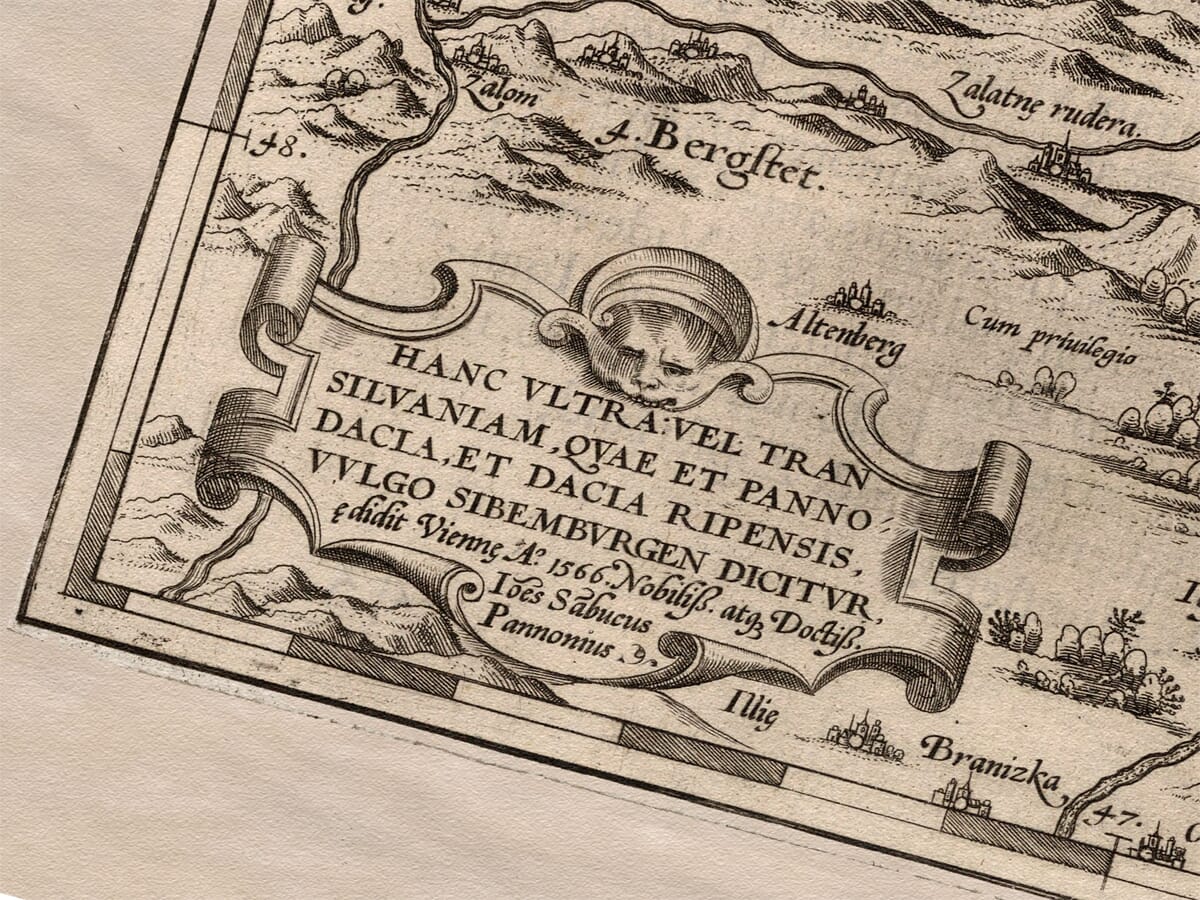
The year 1566 also appears prominently on the map, but it is not the publication date of Ortelius’s plate. The inscription credits Johannes Sambucus, whose map of Transylvania was prepared in Vienna in 1566 and supplied the geographical basis for Ortelius’s engraving.

Map Details

  • Original title: Transilvania
  • Cartographer and publisher: Abraham Ortelius
  • Source cartographer: Johannes Sambucus
  • Earlier cartographic basis: Johannes Honter’s map of Transylvania, 1532
  • Source map prepared: Vienna, 1566
  • Ortelius plate first published: Antwerp, 1570
  • Atlas: Theatrum Orbis Terrarum
  • Engraver: Frans Hogenberg
  • Region shown: Transylvania and adjoining parts of Wallachia and the Kingdom of Hungary
  • Present-day country: Principally Romania
  • Approximate scale: 1:500,000
  • Principal places: Cluj-Napoca, Sibiu, Brașov, Alba Iulia, Bistrița and Bucharest
  • Format: Copperplate engraving
  • Other features: Pictorial mountains, forests, rivers, settlement symbols, title cartouche, source inscription and distance scale

Why 1570 and 1566 Both Matter

Ortelius did not claim to have surveyed Transylvania personally. His importance lay in identifying respected geographical sources and transforming them into maps of a common size and visual style for his atlas.

The lower-left cartouche names Johannes Sambucus and records Vienna and the year 1566. Sambucus was a Hungarian humanist, physician and mapmaker whose geographical work circulated among European scholars.

Sambucus’s map was itself indebted to Johannes Honter’s Chorographia Transylvaniae of 1532, regarded as the first printed map devoted to Transylvania. Ortelius’s plate therefore preserves several successive stages of sixteenth-century cartography.

The correct description is consequently an Ortelius map first published in 1570, based upon Sambucus’s 1566 map—not simply a “Romania map of 1566.”

Transylvania Before Modern Romania

Modern Romania did not exist as a unified country when this map was created. Its central subject is the historic region of Transylvania, enclosed by the great arc of the Carpathian Mountains.

Ortelius extends the engraving beyond Transylvania’s borders. Wallachia appears towards the lower-right edge, while neighbouring areas associated with the old Kingdom of Hungary occupy the west and northwest. Bucharest lies close to the southeastern limit rather than at the centre of the composition.

This coverage explains why the historic name Transilvania appears prominently in the title while “Romania” does not. For today’s viewer, however, most of the map depicts places lying within modern Romania.

Mountains, Rivers and Forests

The Carpathians are the strongest visual feature of the engraving. Individual mountain symbols form long, densely packed chains around Transylvania, communicating the region’s natural enclosure even though the map predates measured contours and modern surveying.

Rivers run from these mountains into the interior and towards adjoining territories. Their winding courses provide a framework around which towns and villages are arranged.

Woodlands are represented by groups of individually engraved trees. Together with the pictorial mountains, these forests give the map depth and movement while conveying the physical barriers that influenced travel, settlement and political boundaries.

Historic Names on the Map

Many recognisable Romanian cities appear under Latin, German or Hungarian forms. Cluj-Napoca is labelled Clausenburg, Sibiu appears as Hermanstadt, Brașov as Corona and Bucharest as Bocaretz.

Alba Iulia, Bistrița and numerous smaller settlements can also be identified through their historic names. These spellings reflect the multilingual character of Transylvania and the sources available to Western European mapmakers.

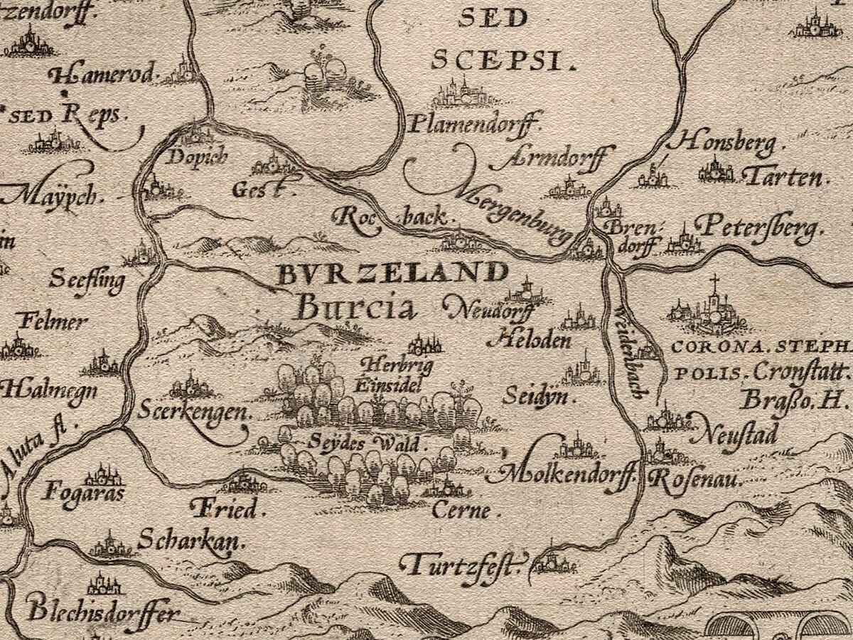
The conspicuous name Burzenland does not identify a city that once overshadowed Bucharest. It is the German name for the historic Țara Bârsei region surrounding Brașov in southeastern Transylvania. Its prominence reflects the importance of this settled district rather than the relative size of one town.

Bucharest at the Edge

Bucharest appears as Bocaretz near the southeastern edge of the map. Its comparatively modest symbol is particularly striking to anyone familiar with its later position as Romania’s capital and largest city.

In the sixteenth century, Ortelius’s subject was Transylvania rather than a unified Romanian state. Brașov, Sibiu, Cluj and other Transylvanian centres consequently occupy more central positions within the engraving.

The placement of Bucharest is therefore not an error. It demonstrates how strongly the map’s geographical emphasis differs from a modern national map of Romania.

Renaissance Cartography

A restrained title cartouche sits at the top of the engraving, while the more elaborate source inscription occupies the lower-left corner. A separate scale cartouche balances the composition on the lower right.

The map contains no modern roads, administrative counties or national frontiers. Instead, mountains, rivers, forests, towns and regional names define the landscape.

Ortelius’s ability to combine this dense geographical information with a clear and balanced composition helped make Theatrum Orbis Terrarum enormously influential. This map remains an absorbing record of Transylvania and the surrounding Romanian landscape at the beginning of the modern atlas age.

You may also like…

  • Old Greek Town PlansOld GreeceAdd to Basket This product has multiple variants. The options may be chosen on the product page

    Greece an early map

    Price range: £35.55 through £59.95
  • Detail from an old map of TransylvaniaOld Map TransylvaniaAdd to Basket This product has multiple variants. The options may be chosen on the product page

    Transylvania

    Price range: £35.55 through £59.95
  • Detail from an old map of GreeceOld Map of GreeceAdd to Basket This product has multiple variants. The options may be chosen on the product page

    Greece

    Price range: £35.55 through £59.95
×
Product added to cart
No products in the cart.