Tonga at the Time of Captain Cook
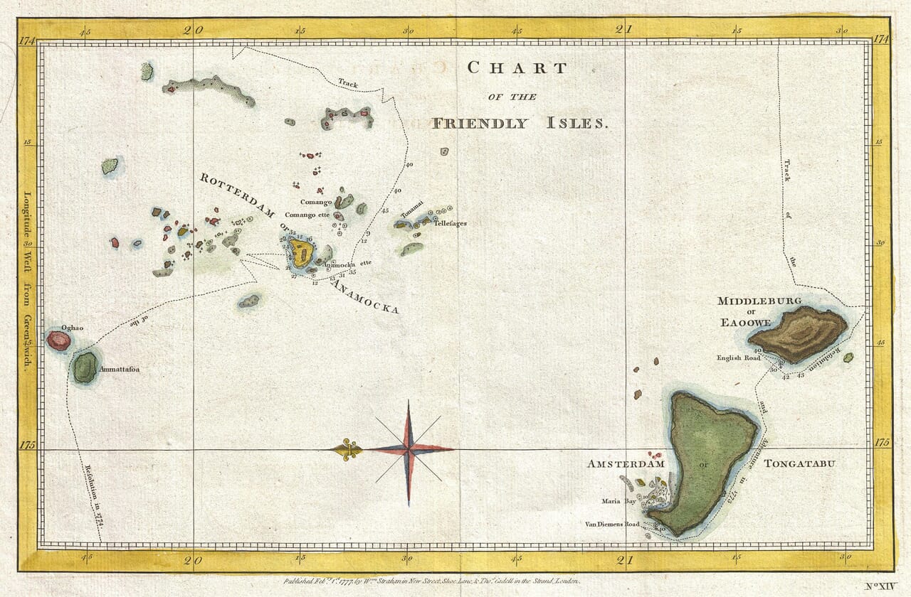
Published in London during the mid-1780s, this chart presents the Tongan archipelago as it was understood following the voyages of Captain James Cook. Rather than depicting Tonga as a single continuous landmass, the map records a far-reaching chain of islands, reefs and anchorages extending across a large area of the South Pacific. Ship tracks crossing the open water reveal how European knowledge of the islands was assembled gradually through direct navigation.
Map Details
Original title: Chart of the Friendly Isles
Publisher: Alexander Hogg
Place of publication: London
Date: c.1785
Map type: Engraved nautical and voyage chart
Region shown: The Tongan archipelago
Principal islands shown: Tongataboo, Middleburg or Eaowe, Anamocka and the central island groups
Notable features: Tracks of the Resolution and Discovery, anchorages, soundings, compass rose, latitude and longitude, historic European and Tongan place names
The Friendly Isles
Cook used the name “Friendly Isles” after the hospitable reception given to his expedition during its visits to Tonga. The expression became established in British geographical writing and continued to appear on maps well into the nineteenth century.
The name reflects the experience and assumptions of visiting Europeans rather than a Tongan name for the islands. Tonga already possessed a sophisticated Polynesian society, its own political hierarchy and an extensive network of communication between its island communities long before Cook’s arrival.
Tongan and European Names
One of the chart’s most revealing features is its use of alternative names. Tongatapu, the principal island in southern Tonga, is labelled “Tongataboo or Amsterdam”. Nearby ‘Eua appears as “Middleburg or Eaowe”.
These European names originated with the Dutch navigator Abel Tasman, who reached the islands in 1643. Tasman named Tongatapu Amsterdam, ‘Eua Middleburg and Nomuka Rotterdam. Later navigators increasingly recorded versions of the islands’ Indigenous names, producing the paired nomenclature visible here.
The chart therefore captures a transitional stage in European cartography. Older Dutch names remain present, but recognisably Tongan names are beginning to take precedence.
Tongataboo and English Road
Tongataboo dominates the lower part of the chart. Its coastline is shown in considerable detail, with offshore islands, channels and navigational hazards carefully marked. “English Road” identifies an anchorage used by British vessels, while Maria Bay and Van Diemen’s Road preserve further evidence of European navigation around the island.
Tongatapu was already the political and ceremonial centre of Tonga. Cook and his officers encountered a cultivated landscape containing settlements, gardens, roads and important religious and chiefly sites. Much of this human landscape could not be represented on a small nautical chart, but the attention given to the island reflects its importance to visiting ships.
The Central Island Groups
Farther north, the chart becomes a complex pattern of small islands and sailing routes. Anamocka—now generally known as Nomuka—is shown among the central islands, together with names including Comango, Comango-ette, Nomanni and Tellagies.
This region was particularly demanding to navigate. Numerous low islands, reefs and confined passages made reliable bearings and soundings essential. The plotted tracks demonstrate how closely ships had to work between the islands while attempting to establish their positions and identify safe anchorages.
Not every coastline could be surveyed with equal confidence. Some islands are represented by little more than an outline or a name, while others receive substantially more detail. These variations make the chart an unusually clear record of cartographic knowledge still being gathered.
The Tracks of the Resolution and Discovery
The engraved tracks of Cook’s vessels transform the map from a simple island chart into a narrative of exploration. The Resolution served during Cook’s second and third Pacific voyages, while the Discovery accompanied it on the third.
Dates and directions placed beside the tracks allow the viewer to follow the progress of the ships through the archipelago. These routes show which islands were approached closely, where vessels changed course and how navigators attempted to connect scattered observations into a coherent geographical picture.
Much of the chart’s historical interest lies in this visible process. It shows not only what eighteenth-century mapmakers believed Tonga looked like, but how that information had been obtained.
Volcanic Islands
The prominently drawn islands of Oghao and Ammattafoa add another striking element. Their steep profiles contrast strongly with the lower islands elsewhere in the group. Ammattafoa is accompanied by an indication of volcanic activity, reflecting the observations reported by Cook’s expedition.
For European readers, such islands reinforced the dramatic image of the Pacific as a region of unfamiliar natural phenomena. On the chart, however, they also performed a practical function: high volcanic peaks could serve as conspicuous navigational landmarks visible at considerable distance.
An Eighteenth-Century View of Tonga
This map predates the nineteenth-century unification of Tonga under Taufa‘ahau, later King George Tupou I. It consequently portrays the islands geographically rather than as the unified constitutional kingdom that emerged in 1875.
Published for a British audience eager to read about Cook’s voyages, the chart brought together navigation, geographical observation and the period’s fascination with the Pacific. Its historic names, delicately coloured islands, compass rose and wandering ship tracks now provide a compelling visual record of Tonga during an important encounter between Polynesian and European worlds.





 Verified owner