Charting the Bahamas and the Windward Passage
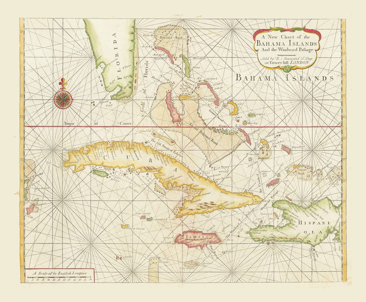
This chart was published in London in 1737 by William Mount and Thomas Page under the title A New Chart of the Bahama Islands and the Windward Passage. It appeared in The English Pilot: The Fourth Book, an influential English sea atlas devoted to navigation around the Americas and the West Indies.
Map Details
Original title: A New Chart of the Bahama Islands and the Windward Passage
Publishers: William Mount and Thomas Page
Place of publication: Tower Hill, London
Publication date: 1737
Published in: The English Pilot: The Fourth Book
Earlier cartographic source: A chart associated with John and Samuel Thornton
Map type: Nautical chart
Region shown: The Bahamas, southern Florida, Cuba, Jamaica and western Hispaniola
Principal Bahamian features: The Bahama Islands, Bahama Bank, Gulf of Florida and the channels between the islands
Other geographical features: The Florida Keys, Tropic of Cancer, Windward Passage and the waters north of Cuba and Hispaniola
Decorative and navigational features: Compass rose, rhumb lines, coloured coastlines, latitude scales and ornamental title cartouche
The map is centred upon the broad Bahama Banks and the long chain of islands extending southeastwards from Florida. Cuba occupies the lower half of the chart, while Jamaica and the western end of Hispaniola establish the southern limits. The arrangement allows the viewer to understand why these islands and channels held such importance to ships travelling between the Atlantic, the Gulf of Mexico and the Caribbean.
A Chart Made for Navigation
The mass of straight lines crossing the water is not decorative patterning. These are rhumb lines, radiating from a series of points and used by mariners to follow a constant compass bearing. Together with the large compass rose west of the Bahamas and the latitude scales around the border, they identify the work as a practical navigational chart.
The Tropic of Cancer passes boldly across the upper part of Cuba and through the Bahamian waters. Shallow banks, reefs, islands and passages are differentiated through engraved outlines, stippling and colour. In these waters, knowing the position of a bank or the entrance to a channel could make the difference between a safe voyage and a wreck.
The Bahamas presented a particular challenge. Hundreds of islands, cays and rocks rise from extensive areas of shallow water, while powerful currents pass through the channels between them. The low profile of many islands made them difficult to recognise from the deck of a ship, especially in poor visibility.
For an eighteenth-century navigator, the chart therefore represented more than the shape of the islands. It offered an organised picture of routes, obstructions and neighbouring landfalls across a notoriously demanding stretch of sea.
Florida, Cuba and the Caribbean Routes
Although the Bahamas provide the subject of the title, the chart covers a much larger maritime region. Southern Florida appears at the upper left, Cuba stretches across the lower centre, Jamaica lies beneath it and part of Hispaniola enters from the southeast.
This wider coverage reflects the realities of navigation. The Straits of Florida formed an important route between the Gulf of Mexico and the Atlantic, while the Windward Passage between Cuba and Hispaniola gave access to the northern Caribbean. Ships sailing between Europe, the mainland colonies and Caribbean ports needed to understand these waters as a connected system.
The chart’s treatment of the Florida Keys and western coast of Florida also reveals the limitations of early eighteenth-century geographical knowledge. Some coastlines are drawn confidently, while others remain distorted or incomplete. Such irregularities are part of the map’s historical interest, showing the information available to London chart publishers rather than the more accurate outlines established by later hydrographic surveys.
The Bahamas after the Pirate Republic
The date of 1737 gives the chart an unusually colourful historical setting. During the late seventeenth and early eighteenth centuries, Nassau on New Providence became a base for privateers, wreckers and pirates. The islands offered sheltered anchorages and waters too shallow for many larger naval vessels, while their position placed them close to heavily used Atlantic and Caribbean shipping routes.
By the second decade of the eighteenth century, Nassau had acquired a reputation as the centre of a loosely organised “Republic of Pirates”. Figures associated with this period included Edward Teach, better known as Blackbeard, Benjamin Hornigold and Charles Vane.
British authority was re-established when Woodes Rogers arrived as royal governor in 1718. He offered pardons to pirates willing to surrender and pursued those who refused. His often-quoted declaration that “expulsis piratis, restituta commercia”—pirates expelled, commerce restored—summed up his ambition to replace disorder with lawful trade.
This Mount and Page chart appeared less than twenty years after Rogers reached Nassau. It therefore belongs to the period when the Bahamas were being drawn more firmly into Britain’s colonial and commercial system, although the chart itself retained geographical information inherited from earlier works.
The English Pilot
The English Pilot was the first major series of sea atlases produced in England. Its fourth book concentrated on American and West Indian navigation and was first issued by William Fisher and John Thornton in 1689. Successive publishers revised and reissued it for more than a century.
The present chart was based upon earlier work associated with the Thornton family of London chartmakers. Mount and Page produced a newly engraved version for the 1737 edition, adding their own imprint within the cartouche: “Sold by W. Mount and T. Page on Tower Hill, London.”
Charts of this kind were working publications rather than maps intended only for display. They could be consulted repeatedly at sea, exposed to damp conditions and replaced when more useful editions became available. Their practical history helps explain why why surviving examples are now particularly valued.
A Decorative Record of Dangerous Waters
The chart balances its navigational purpose with the visual qualities expected from a fine eighteenth-century map. Cuba, Jamaica, Florida and the principal Bahamian islands are differentiated through restrained hand colouring. The coloured compass rose provides a strong focal point, while the flowing title cartouche softens the otherwise disciplined geometry of the chart.
Originally created to guide ships through difficult waters, it now offers a vivid impression of the Bahamas during the age of sail. Its islands, banks, channels and radiating courses preserve the maritime character of an archipelago whose history was inseparable from navigation, trade, shipwreck and piracy.





 Verified owner












