Verified owner
Got there in time and loves it! Cheers David [Gift from US to UK]
 Verified owner
Thanks Lauren. We received it today - it's gorgeous! Thank you, Ellan
 Verified owner
Thank you for your prompt service. I have a gallery and framing business in South Wales. I'm so pleased it is printed in the UK
 Verified owner
My Isles of Scilly map arrived safely and I'm delighted with it!

The print arrived safely and we're delighted with it - a lovely reminder of our honeymoon 15 years ago.
 Verified owner
I have just received them! I'm sure our clients will be pleased with them and there could be more projects off the back of this one where we can use more. [Interior Designers]
 Verified owner
I just received my map of Ireland by Ewart today and, as usual, I am delighted by its quality. The crispness and fineness of detail is excellent and the colour reproduction surpasses my expectations. Please relay my thanks to Steve for another fine effort!
 Verified owner
Many thanks, Lauren. Very pleased with the map and the service: would recommend The Old Map Company to anyone interested in Old Maps.
 Verified owner
Many thanks, the map arrived safely this morning, and I’m really pleased with it. A stunning reproduction, just as I had hoped. I will keep browsing your website, and may yet be tempted by more of your items! Have a great weekend.
 Verified owner
Just arrived, wonderful map! Thanks very much!
 Verified owner
The map – beautiful – arrived safely, very many thanks.
 Verified owner
Thank you, I have already found the map. It’s wonderfull! Good luck! Rasa
 Verified owner
My apologies for the very late reply. I wanted to reach out to thank you so much for rushing my order. My partner absolutely loved it. I am amazed with the service so that is a five-star from me. I wish you all the best.
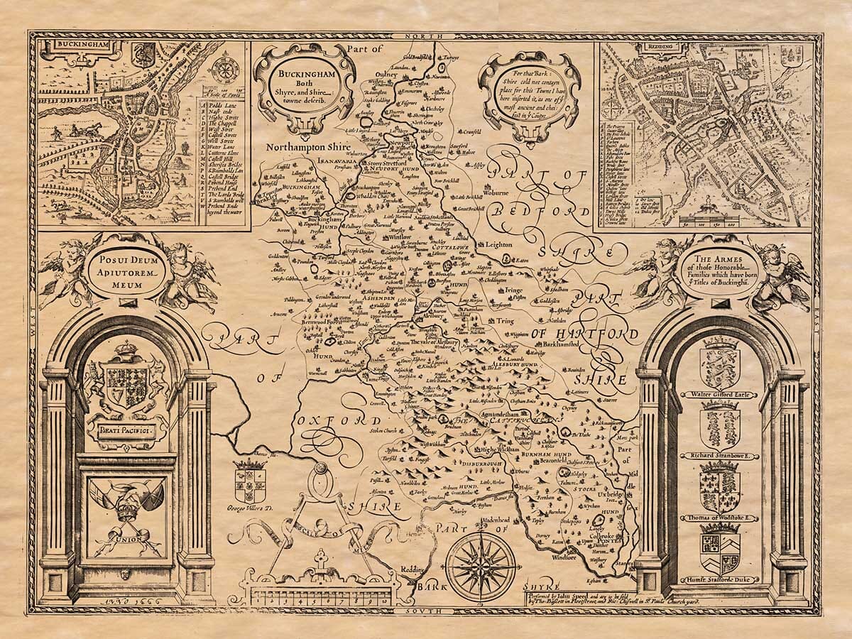
John Speed completed this map of Buckinghamshire in 1610 for his great county atlas, The Theatre of the Empire of Great Britaine. The atlas was first published in London in 1611 and brought together maps of England, Wales, Scotland and Ireland in one of the most ambitious cartographic works produced in early seventeenth-century Britain.
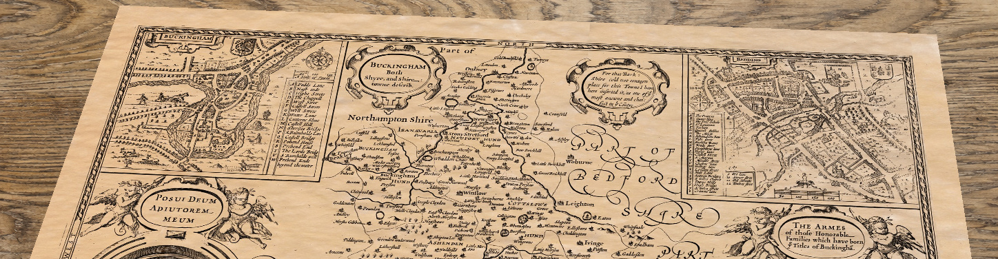
Its engraved title reads Buckingham Both Shyre, and Shire-towne Describ. The spelling belongs to Speed’s period and announces that the sheet presents both the county and its principal town.
The county stretches southwards from the Vale of Aylesbury into the wooded Chiltern Hills and the country bordering the River Thames. Rivers, settlements, forests and groups of individually engraved hills provide the map’s geographical framework; roads are not shown.
Buckingham appears in the north-west beside the winding River Great Ouse. Aylesbury occupies a central position, while Marlow, High Wycombe, Beaconsfield, Amersham and Chesham can be followed through the southern part of the county.
Farther north, Speed records Stony Stratford, Newport Pagnell, Olney and numerous villages that now form part of the wider Milton Keynes area. The map therefore preserves the pattern of separate communities that existed more than three centuries before the development of the modern town.
The Chiltern Hills form one of the county’s defining features. Speed represents the rising ground through clustered pictorial hills rather than measured heights or modern contour lines.
His accompanying description repeated an old story that the Chiltern woodlands once provided shelter for thieves who preyed upon travellers and livestock being driven towards London. Whether taken literally or not, the account reflects the historic reputation of these wooded hills as difficult country through which to travel.
The landscape beyond the Chilterns is filled with farmland, estates and market towns. Names such as Princes Risborough, Great Missenden, Wendover and Ivinghoe remain recognisable, although Speed’s spellings sometimes differ from those used today.


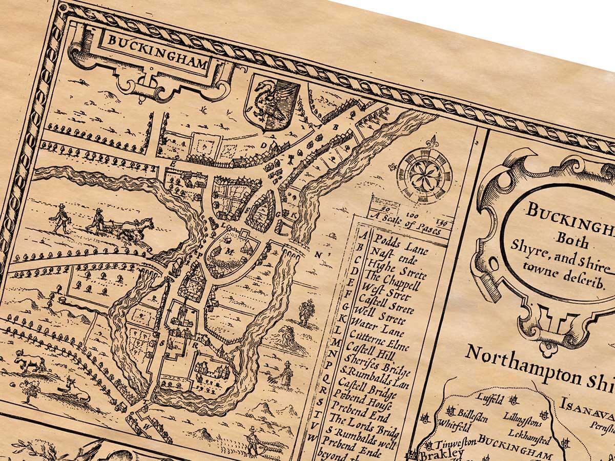
Two finely engraved bird’s-eye plans occupy the upper corners of the map. Buckingham is shown beside the Great Ouse, with its streets, bridge, church and surrounding fields carefully arranged around the river.
The second inset depicts Reading, then commonly written as Redding. Although Reading lies in neighbouring Berkshire, its town plan forms a prominent part of this Buckinghamshire plate. Streets, buildings, waterways and open land provide a fascinating impression of the town before its later expansion.
Many of Speed’s town plans were the earliest printed depictions of the places they represented. They were among the most original features of his atlas and helped distinguish his work from the earlier county maps upon which some of his geographical information was based.
John Speed was responsible for compiling and presenting the map, but its elaborate copperplate engraving was undertaken by Jodocus Hondius in Amsterdam. Hondius was one of Europe’s leading engravers and mapmakers, and his craftsmanship is especially apparent in the town plans, lettering, heraldry and architectural decoration.
The county is divided into its traditional hundreds, while armorial panels record families associated with Buckinghamshire. A compass rose and scale of miles complete a design intended to be studied closely as well as admired.
Speed’s maps remained influential throughout the seventeenth century and were issued in several later editions. This old map of Buckinghamshire still offers an absorbing connection with Buckingham, Aylesbury, the Chilterns and the county’s many historic towns and villages.
Speed’s engraving contains an exceptional number of historic settlements, estates and parish names. The present-day places within the geographical area represented include the following. Some appear on the original map in earlier spellings, while modern communities such as Milton Keynes developed from several older settlements recorded separately by Speed.
A–E: Addington, Adstock, Akeley, Amersham, Ashendon, Aston Abbotts, Aston Clinton, Aston Sandford, Astwood, Aylesbury, Barton Hartshorn, Beachampton, Beaconsfield, Biddlesden, Bierton, Bledlow, Bletchley, Boarstall, Bow Brickhill, Bradenham, Bradwell, Brill, Broughton, Buckingham, Buckland, Burnham, Cadmore End, Calverton, Castlethorpe, Chalfont St Giles, Chalfont St Peter, Chearsley, Cheddington, Chenies, Chesham, Chesham Bois, Chetwode, Chicheley, Chilton, Cholesbury, Clifton Reynes, Cold Brayfield, Colnbrook, Creslow, Cublington, Cuddington, Dagnall, Datchet, Denham, Dinton, Dorney, Dorton, Drayton Beauchamp, Drayton Parslow, Dunton, East Claydon, Edgcott, Edlesborough, Ellesborough, Emberton and Eton.
F–L: Farnham Royal, Fawley, Fenny Stratford, Fingest, Fleet Marston, Foscott, Fulmer, Gayhurst, Granborough, Great Brickhill, Great Hampden, Great Horwood, Great Kimble, Great Linford, Great Marlow, Great Missenden, Great Woolstone, Grendon Underwood, Grove, Haddenham, Halton, Hambleden, Hanslope, Hardmead, Hardwick, Hartwell, Haversham, Hawridge, Hedgerley, Hedsor, High Wycombe, Hillesden, Hitcham, Hoggeston, Hogshaw, Horsenden, Horton, Hughenden, Hulcott, Ibstone, Ickford, Ilmer, Iver Heath, Ivinghoe, Kingsey, Lacey Green, Lane End, Langley Marish, Lathbury, Latimer, Lavendon, Leckhampstead, Lee, Lillingstone Dayrell, Linslade, Little Brickhill, Little Hampden, Little Horwood, Little Kimble, Little Linford, Little Marlow, Little Missenden, Little Woolstone, Long Crendon, Loughton, Lower Winchendon, Ludgershall and Luffield Abbey.
M–R: Maids Moreton, Marsh Gibbon, Marsworth, Medmenham, Mentmore, Middle Claydon, Milton Keynes, Monks Risborough, Moulsoe, Mursley, Nettleden, New Bradwell, Newport Pagnell, Newton Blossomville, Newton Longville, North Crawley, North Marston, Oakley, Old Bradwell, Olney, Oving, Padbury, Penn, Penn Street, Petsoe, Pitchcott, Pitstone, Preston Bissett, Princes Risborough, Quainton, Quarrendon, Radclive, Radnage and Ravenstone.
S–W: St Leonards, Saunderton, Shabbington, Shalstone, Shenley, Sherington, Simpson, Slapton, Slough and Upton-cum-Chalvey, Soulbury, Stantonbury, Steeple Claydon, Stewkley, Stoke Goldington, Stoke Hammond, Stoke Mandeville, Stoke Poges, Stone, Stony Stratford, Stowe, Swanbourne, Taplow, Tattenhoe, Thornborough, Thornton, Tingewick, Towersey, Turville, Turweston, Twyford, Tyringham, Upper Winchendon, Waddesdon, Walton, Water Stratford, Wavendon, Wendover, West Wycombe, Westbury, Weston Turville, Weston Underwood, Wexham, Whaddon, Whitchurch, Willen, Wing, Wingrave, Winslow, Wolverton, Wooburn, Worminghall, Wotton Underwood, Woughton on the Green and Wraysbury.