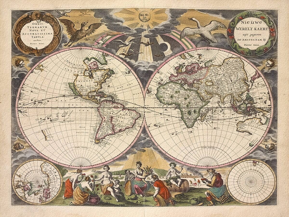
Pieter Goos published his celebrated Orbis Terrarum Nova et Accuratissima Tabula in Amsterdam in 1666.
It formed part of his De Zee-Atlas ofte Water-Wereld, or Sea Atlas or Water World, one of the most admired maritime atlases of its period. Goos’s charts were finely engraved and lavishly presented, and the atlas was issued in numerous editions during the years that followed.
Despite its maritime setting, this map was not designed solely for practical use at sea. The quality of the colouring, engraving and ornament suggests an object intended for the libraries, offices and homes of wealthy clients.
Goos himself described his intended audience by placing gentlemen and merchants before pilots and seamen. In that sense, this map was seventeenth-century executive wall art: a display of knowledge, prosperity and global ambition.
A world beneath the Dutch sun
The two hemispheres dominate the composition, but much of the map’s character lies beyond their borders.
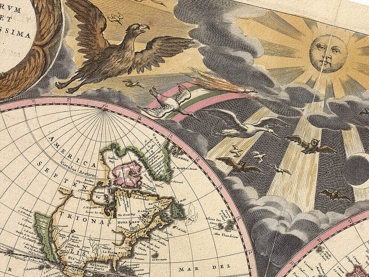
A radiant sun appears high above the world, sending shafts of light through gathering clouds. A flock of birds crosses the sky, including eagles, owls and doves associated with classical gods.
Among them is a goose—a visual joke based upon the name Goos. An exotic bird of paradise is also shown, reflecting the myths and travellers’ tales that reached Amsterdam through Dutch overseas trade.
Faces representing the four winds peer from the surrounding cloudscape, apparently blowing across the oceans and continents.
Tulips, pipe smoke and frozen canals
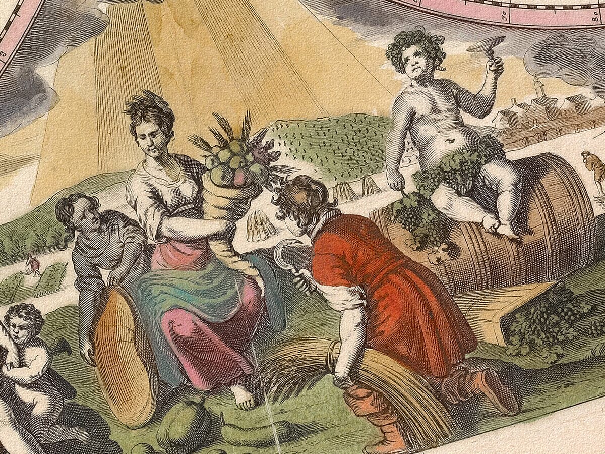
Along the foot of the map, four groups represent spring, summer, autumn and winter, as well as the stages of human life.
Spring receives a pot of tulips, a distinctly Dutch detail even though the notorious tulip-market collapse had occurred nearly thirty years earlier.
Summer and autumn are surrounded by flowers, crops, fruit and abundance. Winter sits wrapped against the cold, smoking a long pipe while tiny figures skate across the frozen landscape behind him.
These charming scenes give the map an unusually domestic quality. The great globe of the world is balanced below by recognisable glimpses of ordinary Dutch life.
California as an island
The geography is equally absorbing.
California is depicted as a large island with a flat northern coast, separated entirely from the North American mainland. This was one of the most famous and enduring errors in the history of mapmaking.
The northwestern coastline of America remains unfinished, revealing just how little of the northern Pacific was known to European cartographers.
Small polar projections appear in the lower corners. The northern polar region contains geographical detail, while the southern projection is almost completely empty. Neither Antarctica nor the old imaginary continent of Terra Australis is included.
Nova Hollandia and the voyages of Abel Tasman
Australia appears under the name Nova Hollandia, with the northern, western and southern coastlines gradually taking shape from Dutch voyages.
Tasmania is also represented following the discoveries of Abel Tasman, although much of Australia’s eastern coast remained unknown to European mapmakers.
The contrast between confidently drawn coastlines and open, unfinished spaces makes the map particularly compelling. It records not a completed world, but one still being assembled from ships’ journals, trading reports, earlier charts and new discoveries.
Art for the well-travelled—or merely curious
The great appeal of this map is that it works on several levels.
From across a room, the two hemispheres, warm colouring and golden sun create an impressive decorative composition. Viewed more closely, the map becomes a collection of stories: exotic birds, frozen canals, mythical geography, unfinished coastlines and the commercial confidence of Dutch Amsterdam.
It would make a memorable centrepiece for a study, home office, library, living room or business interior, particularly for someone interested in travel, maritime history, Dutch art or the age of exploration.
Carefully reproduced and printed individually to order in our Cornwall workshop using archival pigment inks and traditionally textured fine art paper. The print is supplied unframed, allowing you to select a frame that suits your own interior.
What this historic world map shows
- Eastern and western hemispheres
- California represented as an island
- Early mapping of Nova Hollandia, or Australia
- Tasmania following Abel Tasman’s voyages
- Northern and southern polar projections
- A largely empty southern polar region
- The personified four seasons
- Tulips, ice skaters and Dutch domestic scenes
- The sun, clouds and the four winds
- A goose representing the cartographer’s name
- A brightly plumed bird of paradise
- Latin and Dutch map titles





 Verified owner












