



£35.55 – £59.95Price range: £35.55 through £59.95
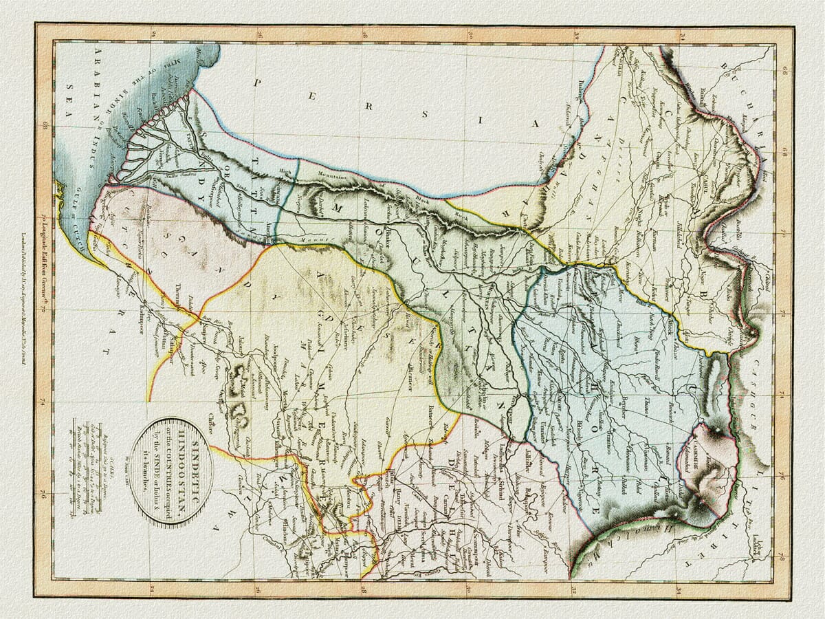
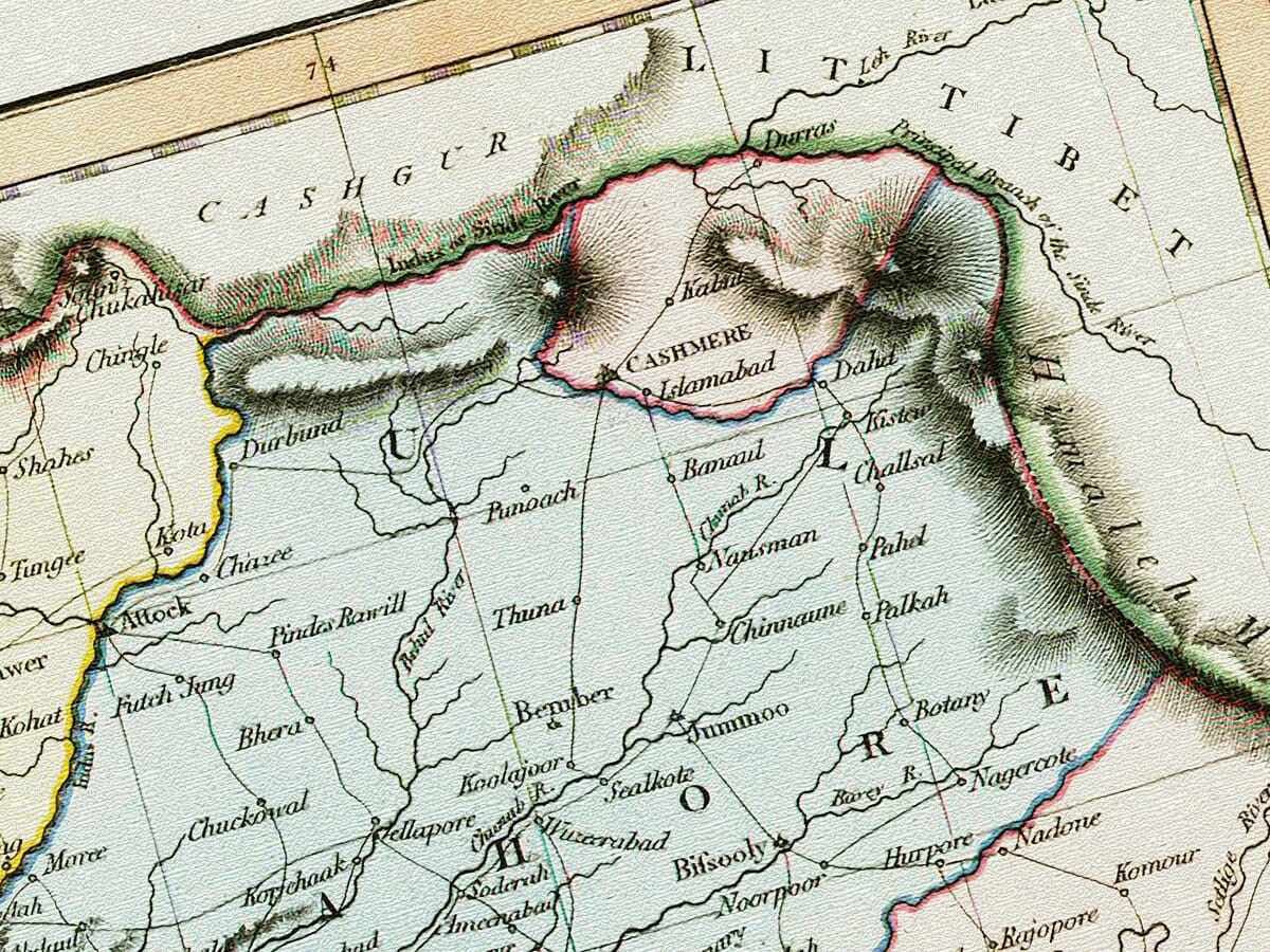
This finely detailed old map of Pakistan and the Indus Valley was published in London by the respected English cartographer John Cary in 1813. Its original title, Sindetic Hindoostan, or the Countries Occupied by the Sinde or Indus & its Branches, reflects the importance of the Indus as the great geographical feature around which the map was organised. Cary follows the river from the mountainous country surrounding Kashmir and Kabul, through the Punjab and Sindh, to its broad network of channels at the Arabian Sea.
The map covers much of the land that now forms Pakistan, together with adjoining parts of Afghanistan and northern India. Lahore, Multan, Peshawar and Hyderabad appear among the many towns and settlements, while the historic regions of Punjab, Sindh, Kashmir, Kabul and Baluchistan can be traced across the sheet. Numerous smaller communities, river crossings and routes give a fascinating impression of how Europeans understood this part of South Asia in the early nineteenth century.
This finely detailed old map of Pakistan and the Indus Valley was published in London by the respected English cartographer John Cary in 1813. Its original title, Sindetic Hindoostan, or the Countries Occupied by the Sinde or Indus & its Branches, reflects the importance of the Indus as the great geographical feature around which the map was organised. Cary follows the river from the mountainous country surrounding Kashmir and Kabul, through the Punjab and Sindh, to its broad network of channels at the Arabian Sea.
The map covers much of the land that now forms Pakistan, together with adjoining parts of Afghanistan and northern India. Lahore, Multan, Peshawar and Hyderabad appear among the many towns and settlements, while the historic regions of Punjab, Sindh, Kashmir, Kabul and Baluchistan can be traced across the sheet. Numerous smaller communities, river crossings and routes give a fascinating impression of how Europeans understood this part of South Asia in the early nineteenth century.
Soft original colouring distinguishes the different territories, while finely engraved hachures give shape to the great mountain barriers in the north and west. The Indus and its tributaries are drawn with particular care, creating an intricate pattern of waterways across the centre of the map.
Published long before the creation of modern Pakistan, this is both an attractive decorative map and an absorbing historical record of the Indus region. It would make a particularly meaningful print for anyone with family connections to Pakistan, Punjab or Sindh, as well as collectors interested in the history and cartography of the Indian subcontinent.
A stunning certified FINE ART PRINT on heavy textured art paper — not a poster
Unlike most online offerings, our maps are produced entirely in-house, not outsourced to print-on-demand or drop-shipping services. This allows complete control over quality while offering better value. Each map begins with a high-resolution original, carefully enhanced and printed to order using archival papers and pigment inks for exceptional clarity, depth, and longevity. Every piece is personally overseen — no map leaves our workshop unless it is of a quality we would be proud to display ourselves.
Paper choice is essential to the authenticity of our maps. We use specially sourced 190gsm paper made in the UK from pure materials and traditionally pressed with natural woollen felts. This process creates a subtle, randomly textured surface that closely resembles an original antique document. Likewise the use of premium quality ink fully saturates the paper, producing remarkable clarity, depth, and historical character. Colour fastness and sharpness will remain good for in excess of 100 years!
The Old Map Company of Great Britain offers a vast and carefully curated collection of the very finest expertly reproduced vintage maps. Our range includes works by renowned cartographers such as John Speed and Willem Blaeu, covering Scotland, England, and beyond. Free UK courier delivery is included, with EU, USA, and worldwide shipping available at cost and calculated at checkout. If you need assistance, our team is always happy to help you choose the perfect map.
Speedy delivery A beautiful representation
Got there in time and loves it! Cheers David [Gift from US to UK]
Thanks Lauren. We received it today - it's gorgeous! Thank you, Ellan
Thank you for your prompt service. I have a gallery and framing business in South Wales. I'm so pleased it is printed in the UK
My Isles of Scilly map arrived safely and I'm delighted with it!
The print arrived safely and we're delighted with it - a lovely reminder of our honeymoon 15 years ago.
I have just received them! I'm sure our clients will be pleased with them and there could be more projects off the back of this one where we can use more. [Interior Designers]
I just received my map of Ireland by Ewart today and, as usual, I am delighted by its quality. The crispness and fineness of detail is excellent and the colour reproduction surpasses my expectations. Please relay my thanks to Steve for another fine effort!
Many thanks, Lauren. Very pleased with the map and the service: would recommend The Old Map Company to anyone interested in Old Maps.
Many thanks, the map arrived safely this morning, and I’m really pleased with it. A stunning reproduction, just as I had hoped. I will keep browsing your website, and may yet be tempted by more of your items! Have a great weekend.
Just arrived, wonderful map! Thanks very much!
The map – beautiful – arrived safely, very many thanks.
Thank you, I have already found the map. It’s wonderfull! Good luck! Rasa
My apologies for the very late reply. I wanted to reach out to thank you so much for rushing my order. My partner absolutely loved it. I am amazed with the service so that is a five-star from me. I wish you all the best.
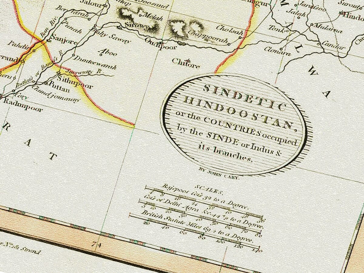
John Cary published this map in 1813 as Sindetic Hindoostan, or the Countries Occupied by the Sinde or Indus & its Branches. It formed part of his New Universal Atlas, an ambitious collection containing separate maps of countries and regions throughout the known world. The surviving catalogue record gives the map an approximate scale of 1:5,500,000 and describes its geographical subject as north-western India, with the relief represented by hachures.
Although we describe it today as an old map of Pakistan, the modern nation did not yet exist. Cary was portraying a much older geographical and political landscape, more than 130 years before Pakistan became an independent country. The boundaries, regional names and centres of power shown on the map therefore belong to a very different period.
The defining feature of the map is the River Indus. Cary’s title refers to the “Sinde or Indus & its branches”, using an older European spelling associated with both the river and the province of Sindh.
From its northern reaches, the Indus flows southwards through a succession of mountain valleys and plains before reaching Sindh. Near the coast it divides into numerous channels, forming the great delta visible at the lower end of the map. The dense pattern of rivers across Punjab is equally prominent, showing why the region became known as the land of five rivers.
For centuries, these waterways sustained agriculture, supplied towns and settlements, and provided routes through an otherwise difficult landscape. On Cary’s map, rivers are not simply decorative geographical features. They form the framework around which much of the country is arranged.
The map includes the courses of major tributaries flowing through Punjab, together with a remarkable number of lesser rivers and streams. Roads and routes run between settlements, often following river valleys or passing through breaks in the mountain ranges.
The territory represented here was divided among several rulers and regional powers when the map was published. Punjab was undergoing a period of considerable change under Maharaja Ranjit Singh, whose expanding Sikh kingdom was centred upon Lahore. In 1813—the same year in which Cary’s map appeared—Ranjit Singh gained control of the strategically important fort at Attock on the Indus. Multan and Kashmir would be incorporated into his territories during the following years.
Further south, Sindh was governed by the Talpur Mirs, a dynasty of Baluch origin whose principal centre was Hyderabad. They retained their independence for several more decades after Cary’s map was published. Sindh was not annexed by the British until 1843, while Punjab followed in 1849. Cary’s map therefore records the region before those major nineteenth-century changes in government and administration.
Afghan influence remained important to the north and west, particularly around Kabul and the approaches to Peshawar. The map extends beyond the limits of modern Pakistan because the Indus Valley was connected to a much broader network of trade, migration and political influence stretching towards Afghanistan, Persia and Central Asia.
Mountain passes provided the principal links between these regions. Cary gives considerable visual weight to the surrounding ranges, especially around Kashmir, Kabul and the north-western frontier. The dark lines of engraved hachures make the mountains appear almost like walls enclosing the river valleys and plains.
Many familiar cities can be found on the map, although their names are sometimes written in older forms. Lahore stands prominently in Punjab, with Amritsar nearby. Multan lies further south, while Peshawar appears close to the mountain routes leading towards Kabul.
Hyderabad and Thatta are shown in Sindh, together with numerous smaller settlements along the lower Indus. Delhi appears near the eastern edge of the map, while Kashmir occupies the mountainous country in the north.
The spelling of place names was not yet standardised. European mapmakers often relied upon earlier maps, travel accounts, military reports and information supplied by merchants or officials. As a result, names such as Cashmere, Cabul, Sinde and Hindoostan appear in forms that differ from modern English usage.
These older spellings are part of the map’s historical interest. They show how British and European readers encountered the geography of South Asia at the beginning of the nineteenth century.
John Cary was one of the leading British map engravers, publishers and globe makers of his period. Born around 1754, he began working independently in 1779 and later established his business in the Strand in London. His premises at 181 Strand became closely associated with the Cary name and appeared on many of his maps and globes.
Cary’s maps are generally admired for clarity rather than excessive ornament. Earlier eighteenth-century maps were often surrounded by elaborate cartouches, figures and symbolic decoration. Cary preferred a cleaner presentation in which roads, rivers, settlements, boundaries and physical geography remained the principal focus.
That approach is clearly visible here. The title is contained within a restrained oval cartouche, leaving most of the sheet available for geographical information. Fine engraved lettering allows hundreds of names to be included without overwhelming the map, while the lightly coloured boundaries help separate the different territories.
Mountain relief is shown with hachures—short engraved strokes laid closely together to suggest slopes and ranges. This was a common method before the widespread adoption of contour lines. The technique gives the northern mountains a strong physical presence and provides an effective contrast with the more open plains of Punjab and Sindh.
Seen today, this map offers more than an early geographical representation of Pakistan. It records a landscape connected by rivers, mountain passes and historic cities at a moment when the political map of the region was changing rapidly.
Modern borders had not yet been drawn, railways had not transformed travel, and cities such as Karachi had not grown into the vast urban centres known today. Instead, Cary presents a world shaped by the Indus and its tributaries, by the mountains of Kashmir and Afghanistan, and by the old routes linking Lahore, Multan, Peshawar, Hyderabad, Kabul and Delhi.
The map’s soft colouring, delicate engraving and wealth of historic detail make it an attractive decorative print. At the same time, its old place names and vanished boundaries provide a rewarding subject for closer study—particularly for those with family, cultural or historical connections to Pakistan and the wider Indus Valley.



