Charting the Maldives in the Eighteenth Century
The Maldives presented European navigators with an unusual cartographic challenge. Rather than forming a single easily recognised landmass, the islands extend in a long double chain of coral atolls, surrounded by reefs, shoals and channels. To a vessel approaching after weeks at sea, the low-lying islands could be difficult to see until the ship was dangerously close.
Map Details
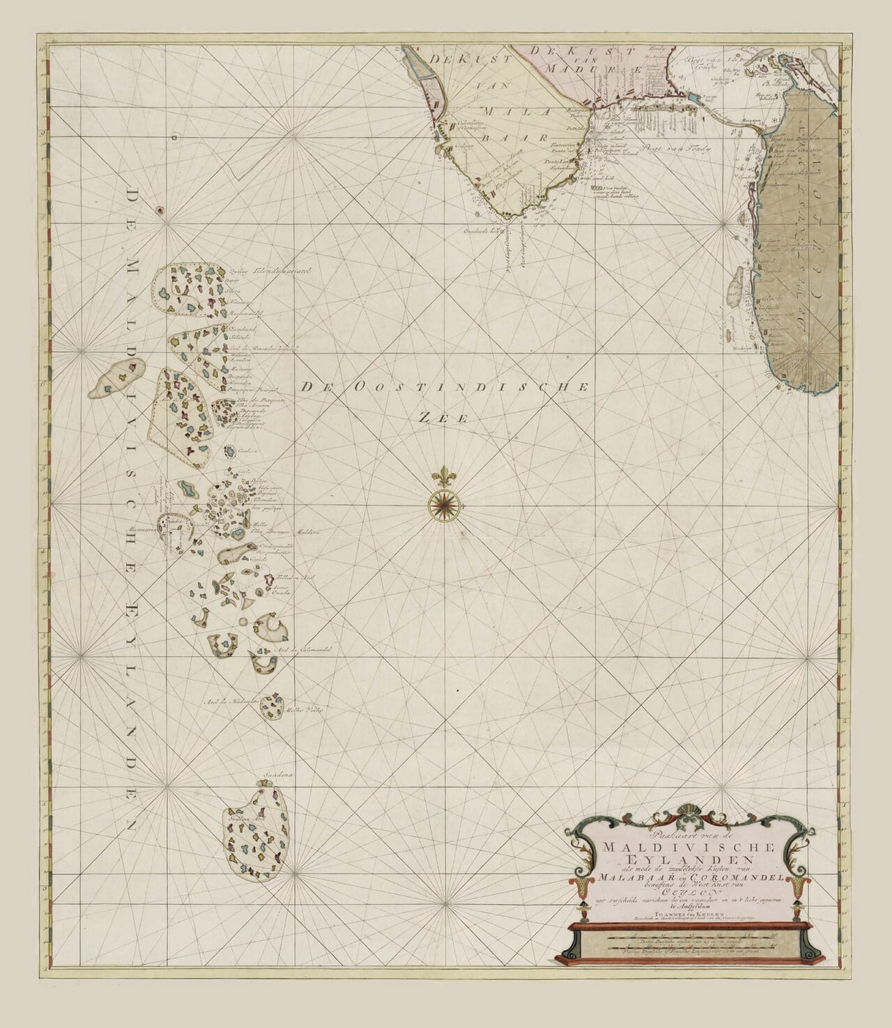
Original title: Paskaart van de Maldivische Eylanden, als mede de zuydelykste kusten van Malabaar en Coromandel, beneffens de west-kust van Ceylon
English title: Sea Chart of the Maldive Islands, including the southern coasts of Malabar and Coromandel and the west coast of Ceylon
Publisher: Johannes van Keulen II
Published: Amsterdam, 1753
Original medium: Coloured copper engraving
Area shown: The Maldives, southern India and the western coast of Ceylon
Notable features: Individual atolls and islands, coastal settlements, compass roses, rhumb lines, maritime observations and an ornamental title cartouche
Johannes van Keulen’s chart gives the Maldives the attention their importance demanded. The archipelago occupies much of the left side of the map, with its separate atolls carefully arranged from north to south. Southern India appears at the top, while the western coast of Ceylon — now Sri Lanka — forms the map’s eastern boundary.
This wider coverage was deliberate. The chart allowed a navigator to understand the Maldives in relation to the principal coasts encountered by ships moving between the Arabian Sea, southern India and Ceylon.
A Chart Made for Navigation
The dense network of straight lines crossing the sea is one of the chart’s most striking features. These are rhumb lines, radiating from compass points to help a navigator maintain a chosen bearing. Their presence immediately distinguishes the work from a conventional geographical map.
A coloured compass rose stands prominently within the open sea. Additional radiating points around the edges extend the navigational framework across the entire sheet. The ocean is therefore not treated as empty space. It becomes a carefully organised working surface upon which courses and positions could be considered.
The coastal areas and islands also carry numerous names and navigational observations. The information is necessarily selective: coastlines, passages and hazards mattered more to a mariner than political boundaries or extensive descriptions of the interior.
The map’s original Dutch title begins Paskaart van de Maldivische Eylanden. The word paskaart identifies it as a sea chart, while Eylanden is an early Dutch spelling of “islands”. The remainder of the title explains that the chart also includes the southern coasts of Malabar and Coromandel together with the west coast of Ceylon.
The Maldives and the Dutch Maritime World
When this chart was published in 1753, Dutch commercial and naval activity in the Indian Ocean already had a history stretching back more than 150 years. The Dutch East India Company, generally known by its initials VOC, had been established in 1602 and developed a far-reaching network of ports and trading routes.
Ceylon held particular importance because of its cinnamon trade and its position beside the sea routes around southern India. Dutch ships travelling between Ceylon, the Cape of Good Hope, the Persian Gulf and other parts of Asia needed dependable knowledge of the waters around the Maldives.
The islands could serve as useful points of reference, but they were also dangerous. Coral reefs, uncertain currents and the difficulty of accurately calculating longitude made navigation through the archipelago hazardous. A chart such as this was therefore concerned not merely with recording islands but with placing them within a connected maritime landscape.
The Van Keulen Chartmaking Family
The Van Keulen firm was among the most important names in Dutch maritime cartography. Johannes van Keulen established his Amsterdam publishing business during the seventeenth century and began issuing the celebrated Zee-Fakkel, or “Sea Torch”, a series of nautical atlases and sailing directions.
The family business continued through several generations. This 1753 edition is associated with Johannes van Keulen II, who maintained the firm’s close involvement with Dutch maritime chartmaking. Institutional catalogues identify him as the publisher of this coloured copper engraving. The chart belongs to a period when the firm had access to accumulated navigational knowledge gathered through Dutch voyages in Asian waters.
Unlike a modern map, it should not be read as a perfectly measured survey of every island. Its value lies partly in showing how eighteenth-century chartmakers organised the information then available and transformed generations of maritime experience into a chart that could be consulted at sea.
A Long Portrait of an Island Chain
The tall format suits the geography particularly well. From the northern groups closest to India, the atolls descend through the centre of the Indian Ocean towards the equator. Individual islands are shown as tiny marks within larger reef formations, giving the archipelago an appearance quite unlike that of the solid coasts to the east and north.
At the lower right, the title is enclosed within an ornamental cartouche enriched with restrained colour. It provides a decorative counterpoint to the disciplined network of navigational lines surrounding it.
The result is an old map of the Maldives with both visual delicacy and a clear practical purpose. It records the islands not in isolation, but as eighteenth-century mariners encountered them: a long, intricate and potentially hazardous presence across the sea routes southwest of India.





 Verified owner