


£39.95 – £49.95Price range: £39.95 through £49.95
Old Map of Suriname and Berbice, 1767
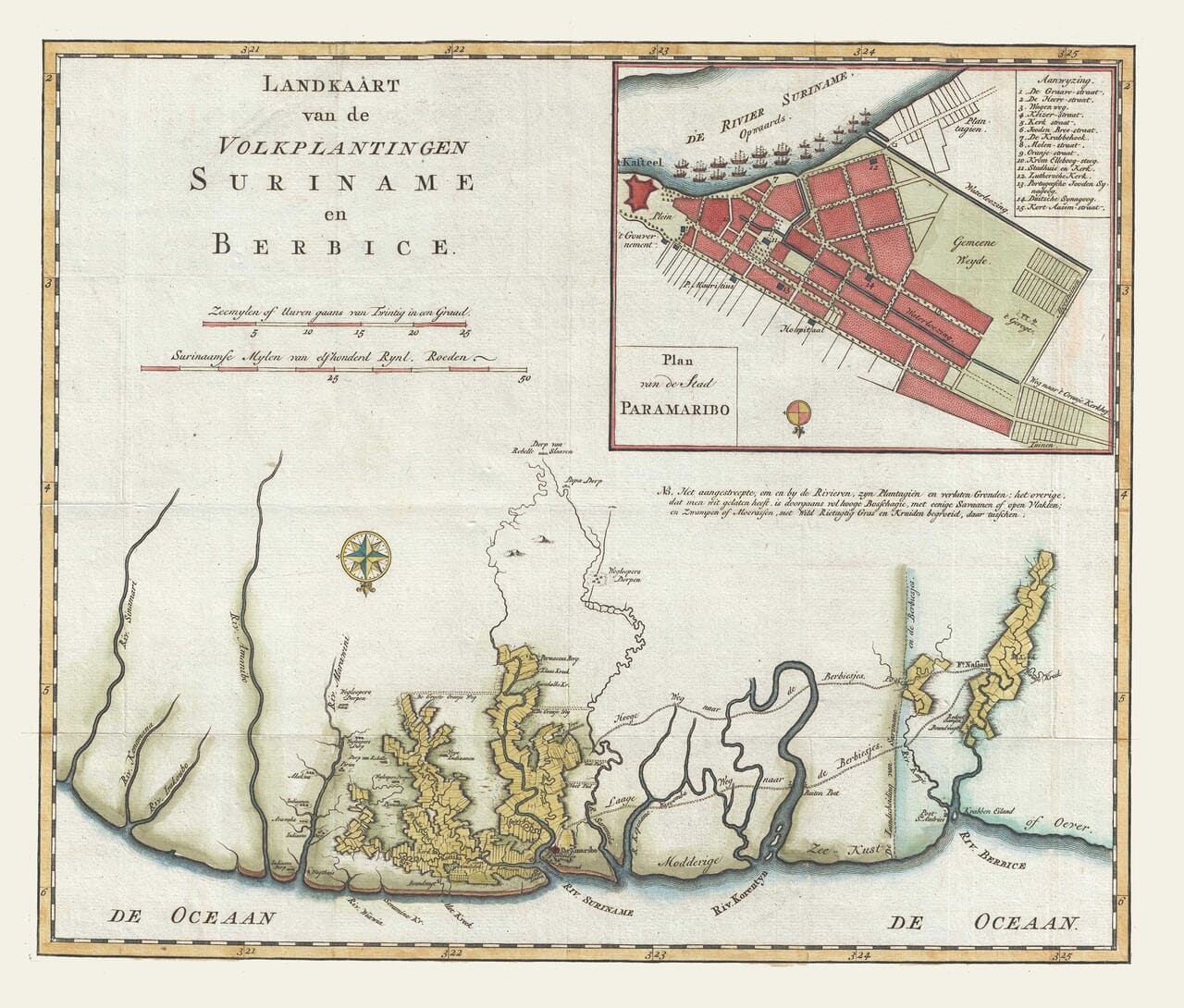
This beautifully coloured eighteenth-century map shows the Dutch plantation colonies of Suriname and Berbice, with their rivers, coastal settlements and carefully divided plantation districts. A detailed inset plan of Paramaribo adds streets, public buildings, churches and synagogues. Reproduced as a fine art print, it is a richly detailed record of Suriname’s colonial landscape and the wider Guiana coast.A stunning certified FINE ART PRINT on heavy textured art paper — not a poster
Unlike most online offerings, our maps are produced entirely in-house, not outsourced to print-on-demand or drop-shipping services. This allows complete control over quality while offering better value. Each map begins with a high-resolution original, carefully enhanced and printed to order using archival papers and pigment inks for exceptional clarity, depth, and longevity. Every piece is personally overseen — no map leaves our workshop unless it is of a quality we would be proud to display ourselves.
Paper choice is essential to the authenticity of our maps. We use specially sourced 190gsm paper made in the UK from pure materials and traditionally pressed with natural woollen felts. This process creates a subtle, randomly textured surface that closely resembles an original antique document. Likewise the use of premium quality ink fully saturates the paper, producing remarkable clarity, depth, and historical character. Colour fastness and sharpness will remain good for in excess of 100 years!
The Old Map Company of Great Britain offers a vast and carefully curated collection of the very finest expertly reproduced vintage maps. Our range includes works by renowned cartographers such as John Speed and Willem Blaeu, covering Scotland, England, and beyond. Free UK courier delivery is included, with EU, USA, and worldwide shipping available at cost and calculated at checkout. If you need assistance, our team is always happy to help you choose the perfect map.
Speedy delivery A beautiful representation
Got there in time and loves it! Cheers David [Gift from US to UK]
Thanks Lauren. We received it today - it's gorgeous! Thank you, Ellan
Thank you for your prompt service. I have a gallery and framing business in South Wales. I'm so pleased it is printed in the UK
My Isles of Scilly map arrived safely and I'm delighted with it!
The print arrived safely and we're delighted with it - a lovely reminder of our honeymoon 15 years ago.
I have just received them! I'm sure our clients will be pleased with them and there could be more projects off the back of this one where we can use more. [Interior Designers]
I just received my map of Ireland by Ewart today and, as usual, I am delighted by its quality. The crispness and fineness of detail is excellent and the colour reproduction surpasses my expectations. Please relay my thanks to Steve for another fine effort!
Many thanks, Lauren. Very pleased with the map and the service: would recommend The Old Map Company to anyone interested in Old Maps.
Many thanks, the map arrived safely this morning, and I’m really pleased with it. A stunning reproduction, just as I had hoped. I will keep browsing your website, and may yet be tempted by more of your items! Have a great weekend.
Just arrived, wonderful map! Thanks very much!
The map – beautiful – arrived safely, very many thanks.
Thank you, I have already found the map. It’s wonderfull! Good luck! Rasa
My apologies for the very late reply. I wanted to reach out to thank you so much for rushing my order. My partner absolutely loved it. I am amazed with the service so that is a five-star from me. I wish you all the best.
This 1767 map presents Suriname and neighbouring Berbice as a network of rivers, plantations and coastal settlements on the Guiana coast. The Dutch colonies were shaped by waterways: the Suriname, Commewijne, Copename, Saramacca and Berbice rivers provided the principal routes into the plantation districts and connected the inland estates with the Atlantic.
Original title: Landkaart van de Volkplantingen Suriname en Berbice Publisher: Reinier and Josua Ottens Publication date: 1767 Publication place: Amsterdam Map type: Hand-coloured copper engraving Area shown: The Dutch colonies of Suriname and Berbice Inset: Plan van de Stad Paramaribo Features shown: Rivers, plantation districts, settlements, coastal features and the streets and public buildings of Paramaribo
The map’s large central panel is dominated by the plantation landscape. Long, narrow holdings extend inland from the rivers, reflecting the way land was surveyed and cultivated under Dutch colonial rule. The orderly appearance of these divisions contrasts with the surrounding forests and less controlled interior, where the map records routes, rivers and settlements beyond the plantation belt.
Paramaribo is shown in a separate inset at the upper right. Its numbered key identifies the town’s principal streets and public buildings, including the government centre, hospital, churches, synagogue and other civic institutions. The town’s position along the River Suriname illustrates its role as the administrative and commercial centre of the colony.
The map also preserves evidence of resistance to plantation authority. Beyond the formally divided estates are references to Indigenous settlements, Maroon communities and villages associated with people who had escaped enslavement or resisted colonial control. These labels are important reminders that the plantation system was contested and that the forested interior was not an empty space beyond European influence.
Suriname’s plantation economy depended heavily on the forced labour of enslaved Africans. Sugar, coffee, cotton and other crops were cultivated along the rivers, while the colonial authorities attempted to maintain control over both the estates and the waterways leading inland. The map’s emphasis on boundaries, rivers and plantation names reflects that system of ownership and administration, but its references to rebel and runaway communities also reveal the limits of colonial control.
Berbice, now part of Guyana, appears to the east of Suriname along the Berbice River. Its inclusion gives the map a broader regional importance, showing how neighbouring Dutch colonies were connected by geography, commerce and shared systems of plantation slavery.
As a wall print, this map combines attractive hand colouring with unusually rich historical content. It offers a detailed view of Paramaribo, the plantation districts and the river network that shaped colonial Suriname, while also preserving evidence of the communities and resistance movements that existed beyond the formal plantation landscape.