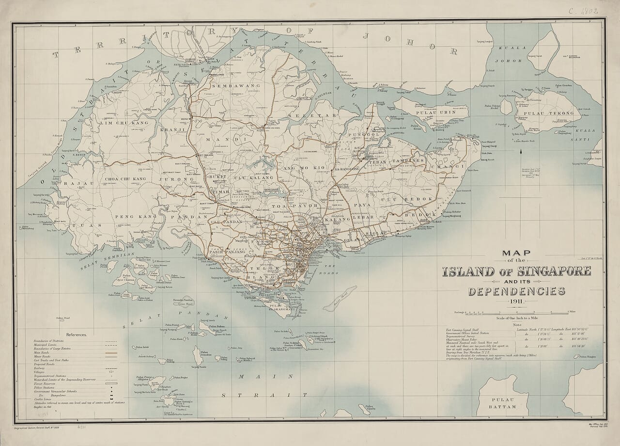
Old map of Singapore in 1911 showing roads, railway, districts and surrounding islands

Old Map of Singapore, 1911

Price range: £39.95 through £49.95

Geographical Section, General Staff — War Office, London, 1911–1912

This beautifully detailed old map of Singapore captures the island at the beginning of the twentieth century, when the city was still concentrated around Singapore Harbour and much of the interior remained divided into plantations, estates, villages and undeveloped land.

Roads, railways, district boundaries and waterways spread across the island, while Singapore Town forms an intricate pattern beside the harbour. Pulau Ubin, Pulau Tekong, Blakang Mati—now Sentosa—and numerous smaller islands are individually named. Across the narrow Old Strait, the coastline of Johor provides a reminder that Singapore’s history has always been closely connected with the Malay Peninsula.

Issued as map sheet GSGS 2609, its restrained colouring and exceptional density of detail make it both a fascinating historical record and a striking fine art map print.
+ read more

A stunning certified FINE ART PRINT on heavy textured art paper — not a poster

  • Direct from the publisher — no middlemen
  • Printed in-house in Cornwall
  • Free UK delivery — international shipping available
  • Produced to meet — and often exceed — museum-quality standards

SELECT SIZE

Inspecting Vintage Map Reproduction

Fine Art Map Reproductions – Museum-Quality Printing

Unlike most online offerings, our maps are produced entirely in-house, not outsourced to print-on-demand or drop-shipping services. This allows complete control over quality while offering better value. Each map begins with a high-resolution original, carefully enhanced and printed to order using archival papers and pigment inks for exceptional clarity, depth, and longevity. Every piece is personally overseen — no map leaves our workshop unless it is of a quality we would be proud to display ourselves.

Hand hold a magnifying glass over West Cornwall Map

Authentic Old Map Paper & Accurate Colour Reproduction

Paper choice is essential to the authenticity of our maps. We use specially sourced 190gsm paper made in the UK from pure materials and traditionally pressed with natural woollen felts. This process creates a subtle, randomly textured surface that closely resembles an original antique document. Likewise the use of premium quality ink fully saturates the paper, producing remarkable clarity, depth, and historical character. Colour fastness and sharpness will remain good for in excess of 100 years!

Map in Postal Tube
Buy Old Maps Online in the UK Today Trading online since 1999

The Old Map Company of Great Britain offers a vast and carefully curated collection of the very finest expertly reproduced vintage maps. Our range includes works by renowned cartographers such as John Speed and Willem Blaeu, covering Scotland, England, and beyond. Free UK courier delivery is included, with EU, USA, and worldwide shipping available at cost and calculated at checkout. If you need assistance, our team is always happy to help you choose the perfect map.

RECENT REVIEWS

Daz
DazGB
Verified ownerVerified owner
5/5

Speedy delivery A beautiful representation

2 months ago
David H
David H
Verified ownerVerified owner
5/5

Got there in time and loves it! Cheers David [Gift from US to UK]

4 months ago
Ellan C-S
Ellan C-S
Verified ownerVerified owner
5/5

Thanks Lauren. We received it today - it's gorgeous! Thank you, Ellan

4 months ago
Ivano Di Battista
Ivano Di Battista
Verified ownerVerified owner
5/5

Thank you for your prompt service. I have a gallery and framing business in South Wales. I'm so pleased it is printed in the UK

4 months ago
Robert B
Robert B
Verified ownerVerified owner
5/5

My Isles of Scilly map arrived safely and I'm delighted with it!

5 months ago
Andrew T
Andrew T
Reviewer
5/5

The print arrived safely and we're delighted with it - a lovely reminder of our honeymoon 15 years ago.

5 months ago
Hannah J
Hannah J
Verified ownerVerified owner
5/5

I have just received them! I'm sure our clients will be pleased with them and there could be more projects off the back of this one where we can use more. [Interior Designers]

5 months ago
Sean MacManus
Sean MacManus
Verified ownerVerified owner
5/5

I just received my map of Ireland by Ewart today and, as usual, I am delighted by its quality. The crispness and fineness of detail is excellent and the colour reproduction surpasses my expectations. Please relay my thanks to Steve for another fine effort!

5 months ago
John G
John G
Verified ownerVerified owner
5/5

Many thanks, Lauren. Very pleased with the map and the service: would recommend The Old Map Company to anyone interested in Old Maps.

7 months ago
Lois K
Lois K
Verified ownerVerified owner
5/5

Thrilled , Lauren! Thank You

7 months ago
Ed Simpson
Ed Simpson
Verified ownerVerified owner
5/5

Many thanks, the map arrived safely this morning, and I’m really pleased with it. A stunning reproduction, just as I had hoped. I will keep browsing your website, and may yet be tempted by more of your items! Have a great weekend.

7 months ago
Daniel McCade
Daniel McCade
Verified ownerVerified owner
5/5

Just arrived, wonderful map! Thanks very much!

8 months ago
Jonathon R
Jonathon R
Verified ownerVerified owner
5/5

The map – beautiful – arrived safely, very many thanks.

1 year ago
Rasa Terbetiene
Rasa Terbetiene
Verified ownerVerified owner
5/5

Thank you, I have already found the map. It’s wonderfull! Good luck! Rasa

4 years ago
Mina M.
Mina M.
Verified ownerVerified owner
5/5

My apologies for the very late reply. I wanted to reach out to thank you so much for rushing my order. My partner absolutely loved it. I am amazed with the service so that is a five-star from me. I wish you all the best.

4 years ago

Singapore on the Eve of Modern Transformation

This map presents Singapore at a revealing point in its history. Its engraved title reads Map of the Island of Singapore and its Dependencies 1911. Although dated 1911, surviving catalogue records indicate that this War Office edition was published in London in February 1912 as Geographical Section, General Staff sheet GSGS 2609.

By then, Singapore had been governed as part of the British Straits Settlements for more than eighty years. The settlement established by the British East India Company in 1819 had grown into one of Asia’s most important trading ports. Yet the map shows an island very different from the intensely built-up Singapore of today.

Singapore Town and its harbour occupy a relatively small area of the southern coast. Beyond them, the island opens into broad rural districts crossed by roads, rivers and tracks. Large names identify Sembawang, Seletar, Mandai, Kranji, Jurong, Choa Chu Kang, Bukit Timah, Toa Payoh, Paya Lebar, Bedok and Pasir Panjang. These are now familiar parts of modern Singapore, but in 1911 they were separated by plantations, woodland, swamps and scattered settlements.

Roads, Tracks and the Singapore Railway

The map’s reference panel distinguishes metalled roads from unmetalled routes, cart tracks and footpaths. It therefore provides an unusually clear picture of movement around Singapore before the construction of its modern road network.

One of its most significant features is the railway running northwards from Singapore Town through Bukit Timah and Kranji to Woodlands. The Singapore–Kranji Railway had opened in stages during 1903. Passengers could travel from Tank Road to Woodlands, where they left the train and crossed the strait to Johor by ferry.

An extension towards the wharves at Pasir Panjang was completed during the same decade. The developing railway made it easier to carry passengers, agricultural produce and other goods between Singapore’s interior and its busy port. It also encouraged residential and commercial growth along its route.

The map predates the Johor–Singapore Causeway. Travellers reaching Woodlands could not yet continue across the strait by train; the permanent rail and road connection with the Malay Peninsula would not open until the 1920s. The railway terminus, ferry connection and still largely undeveloped shoreline opposite Johor belong to a brief period in Singapore’s transport history.

Plantations, Estates and Rural Districts

Singapore Town dominates the southern coast, spreading inland from the Singapore River and the harbour. Its compact concentration of streets and buildings contrasts dramatically with the lightly developed western, northern and eastern parts of the island.

Named estates, villages and agricultural districts appear along the principal roads and waterways. Gambier and pepper cultivation had shaped much of rural Singapore during the nineteenth century, while rubber was becoming increasingly important around the time this map was prepared.

Bukit Timah, Choa Chu Kang, Jurong, Mandai and Sembawang had not yet been absorbed into a continuous urban landscape. Rivers and navigable creeks remained important routes through districts where roads were limited or unfinished.

The island’s developing public infrastructure is also recorded. Reservoirs, government stations, police stations, hospitals and schools are identified in the map’s key. These features reveal that the map was intended as a practical record of a rapidly changing colonial port and the extensive rural territory surrounding it.

A Coastline Since Transformed

The 1911 coastline is one of the map’s most rewarding features. Later land reclamation would substantially alter the harbour frontage and the shores around Pasir Panjang, Jurong and eastern Singapore.

To the south, the map names Blakang Mati Island, today’s Sentosa, together with Pulau Brani, St John’s Island and numerous smaller islands and reefs. Pulau Ubin and Pulau Tekong are shown prominently in the northeast. Across the Old Strait, or Selat Tebrau, part of the Johor coastline frames Singapore’s northern shore.

These islands explain the phrase “and its Dependencies” in the original title. The map was intended to record not only the main island of Singapore but also the smaller islands and surrounding waters administered with it.

An Island Recorded in Remarkable Detail

The Geographical Section, General Staff produced maps for practical government and military purposes. Roads, waterways, settlements, boundaries and communications therefore received close attention. The finished work is both an attractive old map and a valuable administrative record of Singapore before its twentieth-century transformation.

Originally drawn at a scale of one inch to one mile—1:63,360—the map contains an impressive amount of information. Singapore Town appears as a tightly drawn concentration of streets and buildings, contrasting with the more open rural districts crossed by roads, railway lines and rivers. Although the smallest lettering is not intended to be read individually at reproduction size, the map retains a remarkably vivid impression of the island’s settlement and transport network in 1911.

More than a century later, familiar names remain scattered throughout a landscape that has otherwise changed beyond recognition. The map preserves Singapore at the moment when an established trading port was beginning to develop into the modern city-state known today.

Map Details

Original title: Map of the Island of Singapore and its Dependencies 1911

Cartographic authority: Geographical Section, General Staff

Publisher: War Office

Place of publication: London

Map series: GSGS 2609

Map date: 1911

War Office issue: February 1912

Scale: One inch to one mile — 1:63,360

Region shown: Singapore Island, its surrounding islands and part of the Johor coastline

Notable places: Singapore Town, Bukit Timah, Kranji, Woodlands, Mandai, Sembawang, Seletar, Jurong, Choa Chu Kang, Toa Payoh, Paya Lebar, Bedok and Pasir Panjang

Surrounding islands: Pulau Ubin, Pulau Tekong, Blakang Mati—now Sentosa—Pulau Brani and St John’s Island

Features shown: Roads, railway lines, cart tracks, footpaths, district boundaries, rivers, reservoirs, government stations, estates, villages and coastal features

You may also like…

  • BataviaBataviaAdd to Basket This product has multiple variants. The options may be chosen on the product page

    Batavia

    Price range: £35.55 through £59.95
  • Old Map of Borneo detailOld Map of BorneoAdd to Basket This product has multiple variants. The options may be chosen on the product page

    Borneo

    Price range: £35.55 through £59.95
  • East India MapEast India MapAdd to Basket This product has multiple variants. The options may be chosen on the product page

    East India – an old map by John Speed

    Price range: £35.55 through £59.95
×
Product added to cart
No products in the cart.






