John Speed added a short essay which was published on the rear (the verso) of
his old map of The Isle of Wight which we have translated into modern English . . .
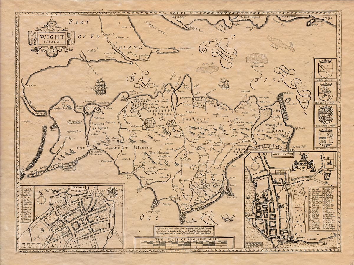
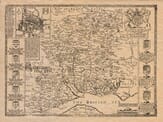
A Description of the Isle of Wight
The Isle of Wight was once called Veta, Vectis, and Vicefis by the Romans, Guyth by the Britons, and Wuiclan’s and Wich-Ea by the Saxons (where Ea means “island”). Today, we call it the Isle of Wight. It is part of the County of Southampton and lies just south of the middle of it. The island is surrounded by the British seas and is separated from the mainland, leading to the belief that its name Guyth comes from the word meaning separation—much like Sicily, which got its name from the Latin word secando, meaning “cutting off.”
The island is long, and its width in the middle is much greater than at either end. From Binbridge Isle in the East to Hurst Castle in the West, it stretches 20 miles. The width, from Newport Haven in the North to Chale Bay in the South, is 12 miles. Its total circumference is about 60 miles.
The climate is praised for both its health benefits and its pleasantness. Its healthy air is shown by how long the inhabitants live without their health declining, and it is more pleasant than any nearby land.
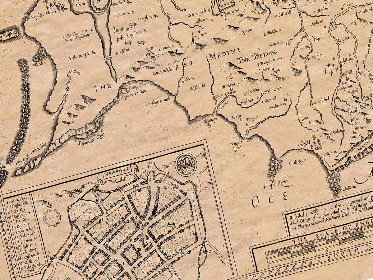
The soil is very fertile, and while the sea is rich with fish, it is the hard work of farmers that allows the land to not only provide for itself but also export corn. The island is rich in cattle and grain and produces plenty of rabbits, hares, partridges, and pheasants. It’s a beautiful place, with meadows, pastures, and parks, making it a perfect environment for sheep farming. The wool produced is highly regarded, only second to that from Leinster and Cotswold. To the North, the land is full of meadows, pastures, and forests. The South is covered with cornfields, and at each end of the island, the sea creeps in to create two smaller islands: Freshwater Isle in the West and Binbridge Isle in the East.
The main commodities of the island are cattle, sea birds, fish, and corn, all in abundance. There are not many forests here, as there is only one small forest. However, the nearby county of Hampshire provides wood, making them close neighbors in that regard, always ready to assist each other.
The ancient inhabitants of the island were the Belgae, mentioned in historical accounts of Somerset, Wiltshire, and Hampshire. The first rulers of the island were known as the Lords of the Isle of Wight until it came into the hands of King Henry I, who gave it to Richard Ridvers along with the town of Christchurch. Richard built fortresses throughout the island.
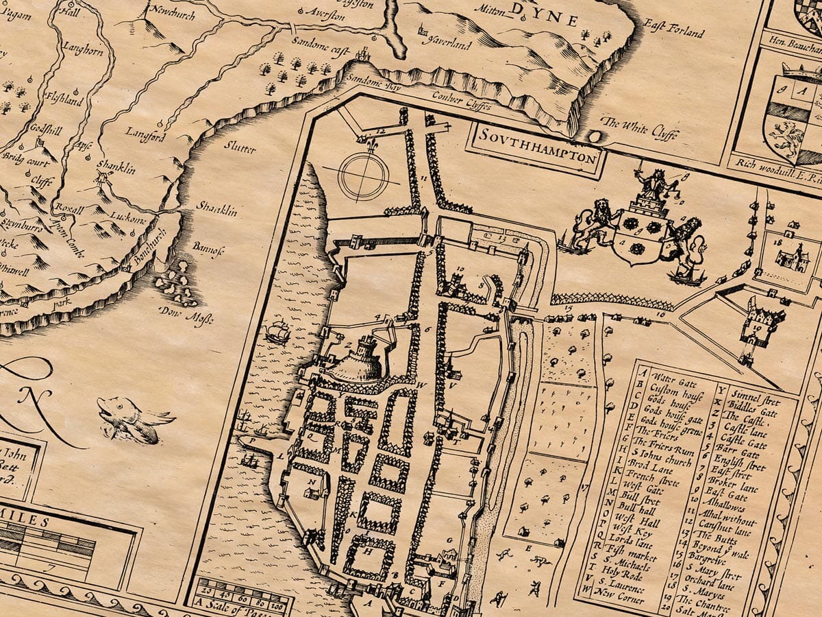
The Principal Market-Town on the Island
The main town is Newport, once called Medena or Novus Burgus de Meden, meaning “The New Town of Meden.” The island is divided into East Meden and West Meden. Newport is well-located, heavily populated, and often visited. The King has granted the town the right to elect a mayor, who governs alongside other officials. The town has an entrance to the island via the harbor, and small vessels can dock at the quay. Not far from Newport is Carisbrook Castle, thought to have been founded by Whitgar the Saxon and originally called White-Garesburgh, which has since been shortened to Carisbrook for easier pronunciation. The town lies at 50° 36′ latitude and 19° 4′ longitude. Once home to a priory, there was also a nunnery at Quarre, nearby. The people of the island joke that they are lucky compared to their neighbors because they never had monks who wore hoods, lawyers who quibbled, or foxes who were cunning.
Strange Occurrences
It is reported that in the year 1167, during the reign of King Henry II, the island experienced a strange phenomenon: it rained blood for two hours, which amazed and terrified the people who witnessed it.
Defences of the Island
The Isle of Wight is well-fortified both by human design and by natural barriers. Besides the strength of its forts and blockhouses, the island is protected by rugged cliffs, rocks, and dangerous banks, like the Needles, which are sharp and treacherous for sailors.
History of Conquest
The island was first brought under Roman control by Vespasian, who served under Emperor Claudius Caesar. Later, it was conquered by the Anglo-Saxons, with Cerdic being the first to subdue it. He granted the island to Stuff and Whitgar, who almost wiped out the remaining British inhabitants in a battle at Whitgaresburgh. Later, the Mercian King Wulfer annexed it, and at that time, he served as godfather to Ethelwalch, the King of the South Saxons. When Ethelwalch died, the island fell under the rule of Cadwalla, King of the West Saxons, who massacred almost every native inhabitant.
Christianity on the Island
The most significant event in the island’s history was when Bishop Wilfrid became the first to introduce Christianity to the island, converting the people from their former idolatry.
Ecclesiastical and Civil Government
For religious matters, the island belongs to the Bishop of Winchester, and for civil matters, it is part of the County of Southampton. The island is fortified with six castles, has four market towns, and is home to 36 parish churches.