Isle of Man
Isle of Man Old map of the Isle of Man Thomas Durham Map

Isle of Man – an old map by John Speed

Price range: £35.55 through £59.95

An Old Map of the Isle of Man by John Speed

Rather different in style to Speede’s other maps from The Theatre and Empire of Great Britain. Adapted from a survey by one Thomas Durham in 1595 and a most attractive old map embellished with Speed’s usual ships and sea monsters. Lovely title piece – ‘The Isle of Man – Exactly described and into several

parishes these divided, with every Town, Village, Bay, Creke, and river therin contained’! Particularly fine detail.

+ read more

A stunning certified FINE ART PRINT on heavy textured art paper — not a poster

  • Direct from the publisher — no middlemen
  • Printed in-house in Cornwall
  • Free UK delivery — international shipping available
  • Produced to meet — and often exceed — museum-quality standards

SELECT SIZE

Inspecting Vintage Map Reproduction

Fine Art Map Reproductions – Museum-Quality Printing

Unlike most online offerings, our maps are produced entirely in-house, not outsourced to print-on-demand or drop-shipping services. This allows complete control over quality while offering better value. Each map begins with a high-resolution original, carefully enhanced and printed to order using archival papers and pigment inks for exceptional clarity, depth, and longevity. Every piece is personally overseen — no map leaves our workshop unless it is of a quality we would be proud to display ourselves.

Hand hold a magnifying glass over West Cornwall Map

Authentic Old Map Paper & Accurate Colour Reproduction

Paper choice is essential to the authenticity of our maps. We use specially sourced 190gsm paper made in the UK from pure materials and traditionally pressed with natural woollen felts. This process creates a subtle, randomly textured surface that closely resembles an original antique document. Likewise the use of premium quality ink fully saturates the paper, producing remarkable clarity, depth, and historical character. Colour fastness and sharpness will remain good for in excess of 100 years!

Map in Postal Tube
Buy Old Maps Online in the UK Today Trading online since 1999

The Old Map Company of Great Britain offers a vast and carefully curated collection of the very finest expertly reproduced vintage maps. Our range includes works by renowned cartographers such as John Speed and Willem Blaeu, covering Scotland, England, and beyond. Free UK courier delivery is included, with EU, USA, and worldwide shipping available at cost and calculated at checkout. If you need assistance, our team is always happy to help you choose the perfect map.

RECENT REVIEWS

David H
David H
Verified ownerVerified owner
5/5

Got there in time and loves it! Cheers David [Gift from US to UK]

1 month ago
Ellan C-S
Ellan C-S
Verified ownerVerified owner
5/5

Thanks Lauren. We received it today - it's gorgeous! Thank you, Ellan

1 month ago
Ivano Di Battista
Ivano Di Battista
Verified ownerVerified owner
5/5

Thank you for your prompt service. I have a gallery and framing business in South Wales. I'm so pleased it is printed in the UK

2 months ago
Robert B
Robert B
Verified ownerVerified owner
5/5

My Isles of Scilly map arrived safely and I'm delighted with it!

2 months ago
Andrew T
Andrew T
Reviewer
5/5

The print arrived safely and we're delighted with it - a lovely reminder of our honeymoon 15 years ago.

2 months ago
Hannah J
Hannah J
Verified ownerVerified owner
5/5

I have just received them! I'm sure our clients will be pleased with them and there could be more projects off the back of this one where we can use more. [Interior Designers]

2 months ago
Sean MacManus
Sean MacManus
Verified ownerVerified owner
5/5

I just received my map of Ireland by Ewart today and, as usual, I am delighted by its quality. The crispness and fineness of detail is excellent and the colour reproduction surpasses my expectations. Please relay my thanks to Steve for another fine effort!

3 months ago
John G
John G
Verified ownerVerified owner
5/5

Many thanks, Lauren. Very pleased with the map and the service: would recommend The Old Map Company to anyone interested in Old Maps.

4 months ago
Lois K
Lois K
Verified ownerVerified owner
5/5

Thrilled , Lauren! Thank You

5 months ago
Ed Simpson
Ed Simpson
Verified ownerVerified owner
5/5

Many thanks, the map arrived safely this morning, and I’m really pleased with it. A stunning reproduction, just as I had hoped. I will keep browsing your website, and may yet be tempted by more of your items! Have a great weekend.

5 months ago
Daniel McCade
Daniel McCade
Verified ownerVerified owner
5/5

Just arrived, wonderful map! Thanks very much!

6 months ago
Jonathon R
Jonathon R
Verified ownerVerified owner
5/5

The map – beautiful – arrived safely, very many thanks.

12 months ago
Rasa Terbetiene
Rasa Terbetiene
Verified ownerVerified owner
5/5

Thank you, I have already found the map. It’s wonderfull! Good luck! Rasa

3 years ago
Mina M.
Mina M.
Verified ownerVerified owner
5/5

My apologies for the very late reply. I wanted to reach out to thank you so much for rushing my order. My partner absolutely loved it. I am amazed with the service so that is a five-star from me. I wish you all the best.

3 years ago
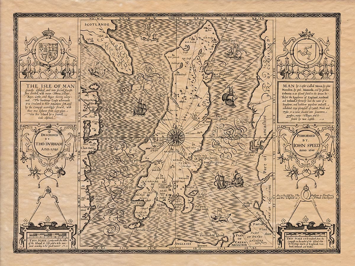
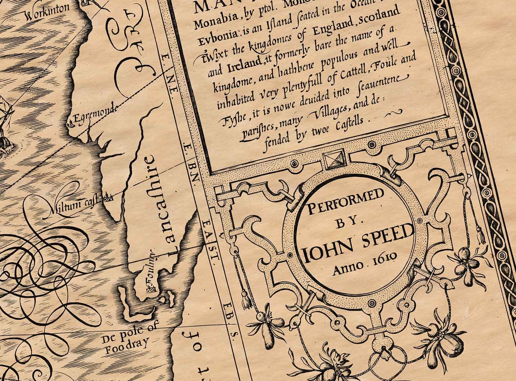
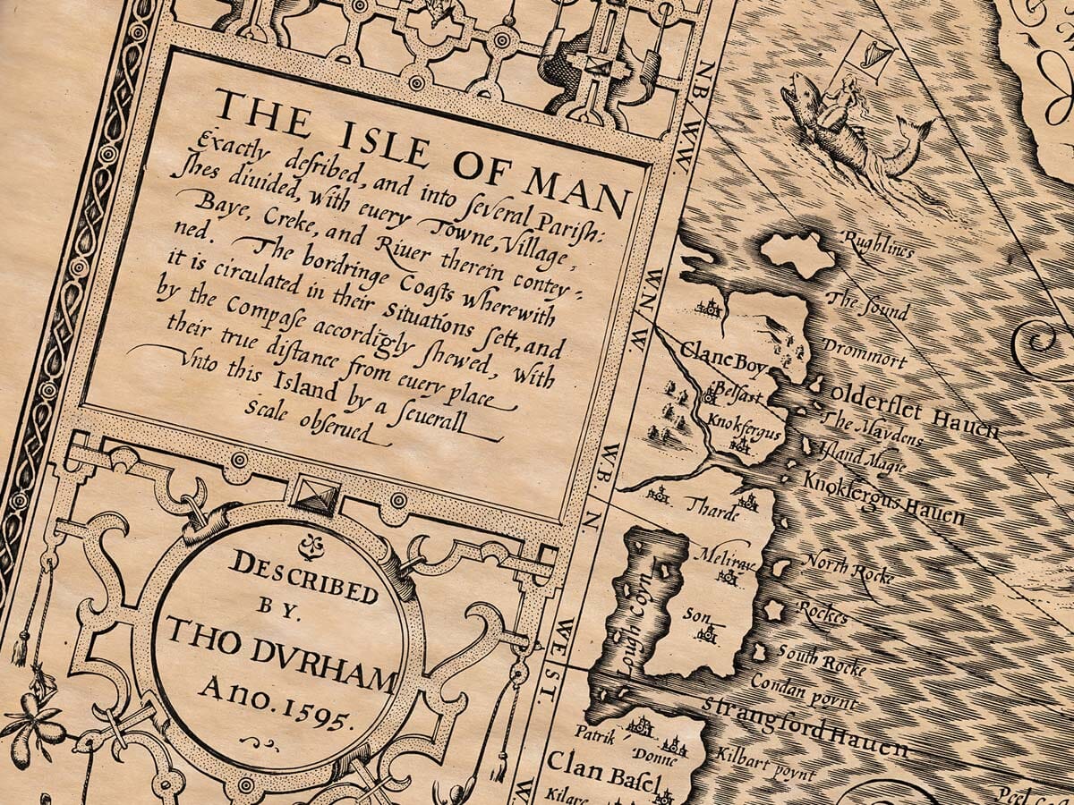
John Speed added a short essay which was published on the rear (the verso) of his old map of the Isle of Map which we have translated into modern English . . . 
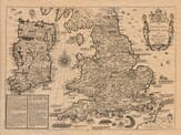
The Isle of Man was called Moneda by Ptolemy, Monabia by Pliny, Menania by Orosius, Menania fecunda by Bede, and Eubonia and Manaw by Gildas. The Britons call it Menow, the inhabitants refer to it as Maninge, and we English call it the Isle of Man. It is located to the north of Scotland, south of the Isle of Anglesey, to the east of part of Lancashire, and to the west, it borders Ireland. 
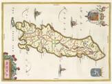
The island is long and narrow: from Cranston to the Mull Hills, where it is longest, it stretches only 29 miles, but from its widest point, from Peel Castle to Douglas Point, it is barely 9 miles wide. The total circumference of the island is about 42 miles. The air is cold and sharp, since the island lies near the northern parts of the world, with only a wall of water providing some shelter. There are few forests, but sometimes, when digging for a type of moist turf used as fuel, people find ancient trees buried underground. The soil is fairly fertile, supporting cattle, fish, and grain. However, it is more a testament to the hard work of the people than to the quality of the land itself. Through the efforts of the inhabitants, the island provides enough for itself and also exports goods to other countries. It has well-fertilized fields that produce plenty of barley and wheat, especially oats. This is why the islanders mostly eat oat bread. The island also grows abundant hemp and flax, and it has large flocks of sheep and other livestock. However, these animals are smaller than those found in England, and they resemble the cattle of neighboring Ireland. One of the island’s advantages is its lack of excessive legal disputes. The people there are free from the usual burdens of lawsuits, long delays in courts, and unnecessary lawyer fees. No judge or court clerk charges any money for drawing up documents or making legal processes. Disputes are resolved by certain judges chosen by the people themselves, called Deemsters. When someone makes a complaint to the magistrate, he takes a stone, marks it with a symbol, and gives it to the plaintiff. With this stone, the plaintiff calls their adversary to court and can bring forward witnesses. If the case is more serious and cannot be easily resolved, it is referred to twelve men known as The Keys of the Island. Another advantage of the Isle of Man is its strong defense. The island is protected from neighboring enemies by soldiers who are always ready. On the southern side of the island is Bala-Curi (the Bishop’s residence), and a fort called Pyle, where there is a continuous garrison of soldiers. The island is so well governed that everyone can live in peace and security. No one fears losing their possessions, and there is little inclination toward theft or lawlessness. Most of the island’s inhabitants are religious and have great respect for their pastors. They attend church services regularly and are united in their faith. The wealthier people, who own the best land, follow the example of people in Lancashire, being honest and maintaining good households. The common people, in terms of language and manners, are closest to the Irish, though they also show some traits of the Norwegians. A notable feature of the island is its landscape, as it is filled with hills, the tallest of which is called Sceaful. On a clear day, one can see three kingdoms from the top: Scotland, England, and Ireland. The island forbids begging from door to door, as it disapproves of the disorderly customs of neighboring nations, both civil and ecclesiastical. Lastly, it is worth remembering that the women of the island, when leaving their homes, wear the winding sheet they intend to be buried in, as a reminder of their mortality. Those condemned to death are sewn into a sack and thrown into the sea from a rock. The island is divided into two parts: the north and the south. One part resembles the Scottish way of speaking, while the other is more like the Irish. The island is protected by two castles and has seventeen parishes, five market towns, and many villages.  

You may also like…

×
Product added to cart
No products in the cart.