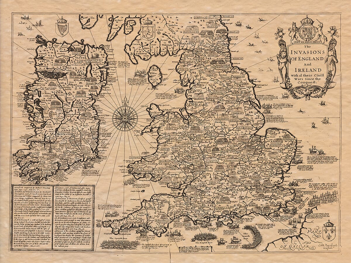
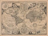
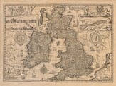
The Invasions of England and Ireland with All Their Civil Wars Since the Conquest John Speed added a fascinating article referencing English Civil wars from the details that appeard on his old UK map:
A Brief Description of the Civil Wars, and Battles Fought in England, Wales, and Ireland
In this platform are contained (Gentle Reader) the several battles fought by sea and land, at several times, and in several places of England and Ireland, and the parts adjoining, within these five hundred years last past. Descriptions of pictures after the manner of fight, as the plot would give room, I have placed; and in the margin by numbers marked, observed the time, year, and event of every battle.
Which being undertaken in satisfaction of the honourable desire of certain martial and noble-minded gentlemen—professors of arms and followers of Mars—desirous to see the present proceedings of their own profession, dealt liberally with me to draw the plot, and with more officious diligence in giving directions, to set down the places, persons, and the issue of every battle fought either by sea or land in England, Wales, and Ireland.
And being finished in a far larger platform, yet to the liking of the monitors, and good acceptance for that then was the mirror of her sex, and the maiden martialist of the then-known world, the glorious and ever-living Queen Elizabeth, to whose sacred courtesy it was commended and dedicated, I intended there to have made it from further sight of publication. Since under the silence of England’s civil wars, better-blessed England’s subjects— they being the marks of her infants, and fain to be washed away rather with repentance than any way revived by too often remembrance.
But these defects I saw could not be so smothered as to be quite forgotten: wherefore I thought it so fit to make her honour known, with our predecessors in far parts, again and intimate my pen into some little better popular treating of the victories of the English, as far as the sun spreadeth his beams, or the girdle of the earth doth any way encircle it.
Not to mention then the richness of Monmouth that makes our Arthur another Cæsar in his conquests; nor Polydore’s show for Exilaster unto Scotland, by the cut of his frown and deep into marble stone—things rather poetical than substantial truths; testimony in Syriac long-fought for the recovery of the Holy Cross, and his sword drawn with blood.
And before him the Conrad Lion upon the same intent subdued Cyprus, forced Cary the King thereof into restraint, and got a casket of diamonds to hand to himself; whose title he entered to have changed into that of Jerusalem: unto whom when King Richard came, with Geoffrey de Lusignan his brother, and Raymond Prince of Antioch, who promised his sword, swore fealty to be true and loyal subjects. Raymond his son he gave for the heavy ransom of Edward and Henry our English Kings: when the one of them was prisoner to the French, John King of France, and Philip maintained the hardy, his son. And the other at Azincourt, in a bloody battle, took and slew 4,000 princes, nobles, knights, and esquires, even all the flower of France, as their own writers have declared.
And at Paris the Crown of France was set upon Henry the Fifth’s head, homage done unto him of the French; that kingdom made subject, and their fleur-de-lis quartered with our Lion of England; Scotland likewise, till the flower of Henry the Second, when their King William was taken prisoner in the field. And at one Newbattles, they made themselves subjects to England. And at St. Cross, David King of Scotland was taken in battle by the English (Queen Philippa, wife to King Edward the Third, being present in field), and both the Kings of France and Scotland, at one time entered prisoners of England, till their freedom was obtained by ransom.
Nor was Spain free from our England’s power, when that thunderbolt of war (our Black Prince) re-established Peter, their King, upon his throne at Burgos: to say nothing of the ruins Spain suffered at our desires, by the English led by Essex, in revenge of their unvanquishable, invincible navy—in truth the seal of their truth-less cowardice unto this day.
And not only the Garter which King Richard the First yet doth keep of his soldiers, remains till the Royal bound of England: combatants at Tournay held Round Table of six hundred foot circumference erected at Winfield by King Arthur: nor the valour of the martialists—many hundred pounds by week for the diet of his martialists—may likewise witness. For the which, duly admitted by conference and continual practice, got such experience in might of arms, that thus that which was said of the Gauls—men that have been held of them: They were all valiant men apt for several battles and could handle spear and shield; their seats are from the seats of lions, and were like the rove in chasing of the fiercest.
In whose imitation Philip de Valois, then French King, entered in like manner to this, bound his knights, proved not in courage like unto Edward. And from this Academy of Military Professors commenced such masters of military discipline as Maximilian the Roman Emperor had it for honour to be incorporated into their societies; as himself became the King of England’s professed follower, wore the Cross of St. George (the royal ensign of England) and a rose (the King’s badge) as his faithful soldier, receiving his pay along for himself and followers, according to their degrees and estates.
Neither were the achievements of the land services crowned with more places of victories in the helmets of the English than were their sea-services, defensive and offensive, both at home and abroad. The Navy Royal, rightly termed the Lady of the Seas, and their sea-captains far out-stripping Ulysses in their travels and descents, that not only twice in one turn hath she opened her passage through the Straits of Magellan, for Drake in his peril and Candish in his desire to pass into the South World and to in search the globe of the whole earth; but have themselves and soldiers (all English) in those great deserts so wonderfully wrestled with nature (as a proud subject) I could willingly insert, were it not that the argument of this present description intends rather to speak of the domestic and civil wars of England than of the fore-reigning and far-fetched victories that have adorned and eternalised the trophies of the English.
From the production of them, and prolongation of the latter, how unwillingly my pen is drawn, the roughness of the style and the sharp performance of the whole doth manifestly show. They being for the most part civil battles fought between men English—men of one and the same nation—when in the parts of its victors, besides the loss of their own side, is procured on the other the fall and ruin of them that were left alive; own countrymen, many of them of his own acquaintance and alliance, and not of them perhaps his enemies in any other cause than that in which he contended.
But forasmuch as this general argument to proceed to some particulars, it shall not be amiss to make some mention of the general titles of their several qualities of the several quarrels in them which are found to be divers, and of three several natures. Whereof the first were the invasions attempted by foreign princes and enemies against the kings and people of this realm. The second were mere rebellions of subjects against their anointed princes. And the third, dissensions and factions betwixt princes of the blood royal; of these all three the distinctions of blood have conflicted.
And to begin with the first battle in this plot, which was the first beginning of government of this state as it consisteth: such was the attempt of William, Duke of Normandy, against King Harold, the Earl of Goodwin, who prevailed to gain in right at Battle in Sussex (a place so called by this event) as the said Duke was afterward King of this land, and brought the whole nation under his obedience, as it hath been continued to his posterity ever since.
Such was the arrival of Lewis, son and heir to Philip King of France, against John King of England, who being carried by his own ambition, accompanied with French forces, and aided by the rebellious barons of this realm, at the variable fortune of fight in several skirmishes, battles and assaults, was forced in the end, with small honour or hope to prevail, to make a very shameful retreat into his own country.
Such also was the mighty James the Fourth, King of Scots, against King Henry the Eighth of famous memory, his brother-in-law and then own ally, at that time abettor in the wars of France, who, out of their league and alliance formerly made, entered the north frontiers of England with a mighty army, had the dishonour and overthrow, and was himself slain in the field by the English forces, under the leading of the Earl of Surrey, at that time Lieutenant-General for King Henry.
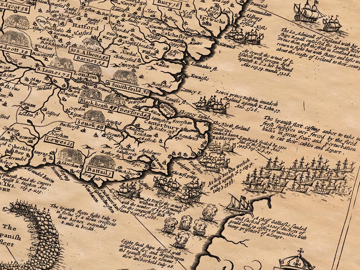
And especially notable was the late enterprise, remaining fresh in memory, of Philip King of Spain against our dread sovereign lady now reigning, in the year of our Lord 1588; attempting by his invincible navy (as he thought, and so termed) under the conduct of the Duke of Medina Celi, with much pride and cruelty intended against us, arrived on our coasts on the English invasion and fortification, and yet nevertheless here in the Narrow Seas the one part of his fleet confounded, taken, and drowned, and the other part forced to their great danger in poor estate to make a fearful and miserable flight about the coasts of Ireland homeward, to that fatal 1588, for ever to be remembered, when the coasts of Spain beat and those fore-torn and beaten by the English power, as that it was thought they were unserviceable for ever, and eleven of their ensigns or banners of idolatry, prepared for triumph and pride in conquest, were contrarily to their shame and dishonour showed at Paul’s Cross and in other places of this realm.
There then follows within the references appertaining to this Old Map UK a list of The Battles:
And BATTELS fought in ENGLAND, FRANCE and IRELAND. (5)
1066 At Hastings in Sussex, William L. of Normandy, Wm. Erle of Morton, Robert Earle of Mortaigne, and the Norman power, slew Harold K. of England, and won the Realm.
1088 Mowbray and other Lords against William Rufus, taken at Pevensey.
1135 Matilda the Empress against Stephen K. of England, with Robert Earle of Gloucester her brother, who tooke the King prisoner at Lincolne, but after lost the field at Winchester.
1174 William King of Scots, taken at Alnwick by the English.
1215 The Barons war against King John for Magna Charta.
1264 At Lewes, May 14, Simon de Montfort E. of Leicester took Henry the 3. prisoner, and his sonne Prince Edward.
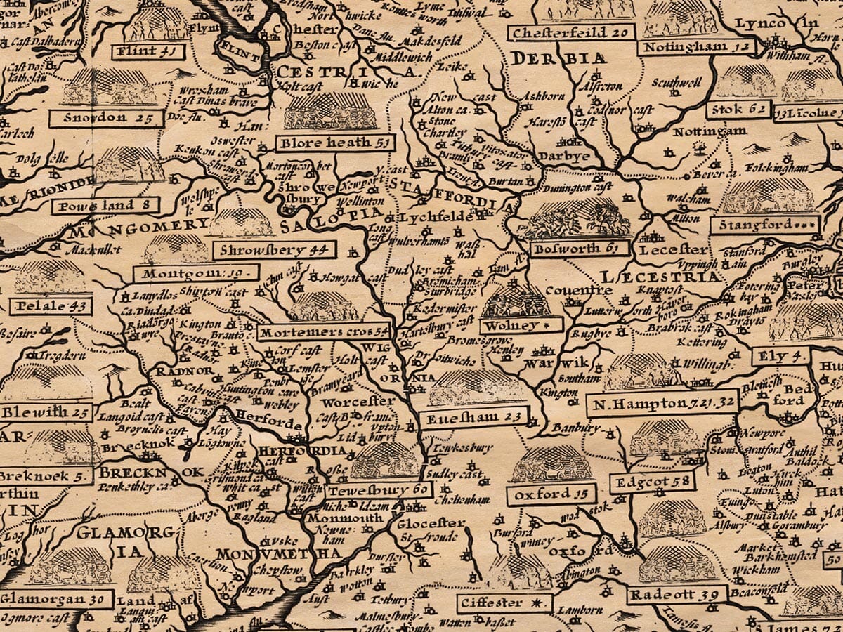
1265 At Evesham, the same Simon de Montfort was slain by Prince Edward.
1322 Thomas Earle of Lancaster, with other Barons, rose against King Edward the 2. and were taken and beheaded.
1327 Edward the 2. deposed by Queen Isabel his wife, and her son Prince Edward.
1346 Edward the 3. at Cressy in France, discomfited Philip de Valoys K. of France.
1356 At Poitiers, Edward the black Prince took John the French King prisoner.
1378 Wars in Flanders, Gaunt against their Earle.
1381 The commons of England rebelled, under Wat Tyler, Jack Straw, &c.
1402 At Homildon Hill, George E. of Dunbar, Percy, and the Scots discomfited by the English.
1403 At Shrewsbury, Henry the 4. against Henry Percy, who was there slain.
1415 Henry the 5. at Agincourt, discomfited the French.
1450 Jack Cade and the Commons of Kent, at Black-heath, rebelled against Henry the 6.
1455 At S. Albans, Richard D. of York, and Richard Neville E. of Warwick, against King Henry the 6.
1460 At Northampton, the same D. of York and E. of Warwick against the same King, took him prisoner.
1461 At Towton field in Yorkeshire, Edward E. of March against Henry the 6. won the field.
1470 Henry the 6. restored by the E. of Warwick.
1471 Barnet field, Edward the 4. against the E. of Warwick, where Warwick was slain.
1471 Tewkesbury field, Edward the 4. against Queen Margaret and her son Prince Edward, who was slain.
1485 Bosworth field, Henry Earle of Richmond against King Richard the 3. who was there slain.
1513 At Flodden in Northumberland, Thomas E. of Surrey for Henry the 8. discomfited James the 4. King of Scots, who was there slain.
1536 The Pilgrimage of Grace in Lincolnshire, Yorkeshire, &c.
1542 At Solome-Mosse, the Scots overthrown by the English.
1544 At Muscleborough, the Scots again overthrown by the English.
1549 The Devonshire and Cornishmen rose for the Masse, and were subdued by John Lord Russel, E. of Bedford.
1549 Kett’s Rebellion in Norfolk, suppressed by John E. of Warwick.
1553 Sir Thomas Wyat in Kent rebelled against Queen Mary, but taken and executed.
1569 The Earls of Northumberland and Westmorland rebelled against Queen Elizabeth, but fled into Scotland.
1588 The Spanish Navy (called the Invincible Armada) came into our seas, but by God’s providence was overthrown.
1595 In Ireland, Tyrone rebelled; many conflicts between the English and Irish followed for several years.
1598 Sir Henry Bagnall slain in Ulster by the rebels.
1601 The Earle of Essex, Robert Devereux, rose in London, but was suppressed and executed.
At St. Albans First Battel (1455) May 23. Richard Duke of
York, Richard Earle of Warwick, against Henry 6.
slue the Duke of Somerset, Henry the 2. of Buckingham,
the Earle of Northumberland, Lord Clifford, and took
the King prisoner.
At Blore-heath field in Stafford-shire (1459) Sept. 23.
James Lord Audley for Henry 6. was discomfited by
the Lord Salisbury.
At Northampton field (1460) July 20. Richard Earle of
Warwick, and Edward Earle of March, against K. Henry 6.
took him prisoner, slew the Duke of Buckingham, and
the Lords Egremont and Shrewsbury.
At Wakefield Battel (1460) Dec. 30. Richard Duke of
York, the Earle of Salisbury, and many others, were slaine
by Queen Margaret and the Lord Clifford.
At Mortimer’s Crosse (1461) Feb. 2. Edward Earle of March
defeated Jasper Earle of Pembrooke, and the Earle of Wiltshire.
At S. Albans second Battel (1461) Feb. 17. Queen Margaret
discomfited the Earle of Warwick.
At Towton field (1461) March 29. Edward Earle of March
obtained a most bloody victory against K. Henry 6. and
Queen Margaret, where were slain 38000.
At Hexham (1464) May 15. John Nevill Marquis Montacute
overthrew Henry Duke of Somerset, and took him prisoner.
At Hedgeley Moor (1464) April 29. the same Marquis
Montacute overthrew Sir Ralph Percy.
At Edgcote (1469) July 25. the Northerne men for Queen
Margaret slew the Earle of Pembroke and his brother.
At Stamford field (1470) March 1. Sir Robert Wells with
the Rebels was defeated by King Edward 4.
At Barnet (1471) April 14. Edward 4. slew Richard Nevill
the great Earle of Warwick, and his brother the Marquesse
Montacute.
At Tewkesbury (1471) May 4. Edward 4. obtained the
victory against Queen Margaret, took her prisoner, and
slew her son Prince Edward.
At Bosworth field (1485) Aug. 22. Henry Earle of Richmond
slew Richard 3. and obtained the Crown.
At Stoke field (1487) June 16. Henry 7. slew the Lord
Lovell and Martin Swart the German.
At Blackheath field (1497) June 22. Henry 7. overcame
the Cornish Rebels.
At Flodden field in Scotland (1513) Sept. 9. Thomas
Howard Earle of Surrey, for Henry 8. overthrew James 4.
King of Scots, who was there slain.
At Norfolk (1537) the Rebels were suppressed by the Duke
of Norfolk.
At Musselborough (1547) Sept. 10. the Protector Duke of
Somerset obtained a notable victory against the Scots,
where were slain 15000.
At Wyling (1549) Lord Grey overthrew the Rebels of Devon.
At Norwich (1549) the Earle of Warwick discomfited
Kett and his Complices.
At Seamer in Yorkshire (1549) the Lord President
overthrew the Rebels.
At Blackheath (1554) the Duke of Norfolk overthrew
Sir Thomas Wyat.
At St. Quintins in Picardy (1557) Emanuell Duke of
Savoy for Philip King of Spain defeated the French.
At Gynes and Calais (1558) the French won those
places from the English.
At Leith in Scotland (1560) the English forced the French
to a composition.
At Newhaven in France (1562) the English kept the
Towne a time, but were forced to leave it.
At St. Denis (1567) the Prince of Condé and Admiral
Coligny fought with Anne de Montmorency, Constable of
France.
At Moncontour (1569) the same Admiral overthrown by
the Duke of Anjou.
At Jarnac (1569) the Prince of Condé slain.
At Antwerp (1576) the Spaniards mutinied, sackt the City,
slew 8000.
At Gemblours (1578) Don John of Austria, and Alexander
Duke of Parma, defeated the States army.
At Renty (1554) the French King Henry 2. and the
Emperor Charles 5. fought a great battel.
At Dreux (1562) the Prince of Condé defeated by the Duke
of Guise.
At Coutras (1587) Henry of Navarre overthrew the Duke
of Joyeuse.
At Ivry (1590) Henry of Navarre overthrew the Duke of
Mayenne.
At Amiens (1597) the Spaniards took the Town, but were
forced to render it.
And BATTELS fought in ENGLAND, FRANCE and IRELAND. (7)
A Continuation of all the Battels fought in England, Ireland, and France, since the Conquest, with the year and event.
1588 The Spanish Armado of 1588 came to Cadiz and Calais, was scattered, and miserably lost.
1589 At Saint Mary’s, May 1, 1589, Sir Francis Drake, Sir John Norris, with 150 sail of Ships, burned the Spanish Navy, took 20 Towns, and destroyed great store of Ordnance and Munition.
1595 Patrick O’Cane, in Ulster, slew Sir John Chichester the Governor, and 500 English.
1596 Sir Francis Drake, and Sir John Norris, took and burnt Cadiz.
1598 In Ulster, Tyrone slew Sir Henry Bagnall and 1500 English, with most of their Officers.
1599 Essex sent Lord Mountjoy into Ireland, who brake Tyrone’s forces.
1601 Tyrone and O’Donnell at Kinsale were utterly discomfited by the Lord Deputy Mountjoy, and the Spaniards forced to yield.
1603 New Worcester Complot against the life of King James, discovered.
1607 The Earls of Tyrone and Tyrconnell fled into Spain.
1608 Sir Cahir O’Dogherty raised a rebellion in Ulster; was taken and slain.
1615 English conspirators, with Guy Fawkes at their head, plotted to blow up the Parliament House with Gunpowder; discovered the 5 of November.
1625 Cadiz voyage: the English under Sir Edward Cecil, failed in the attempt on Spain.
1627 Isle of Rhé: the English under the Duke of Buckingham were defeated.
1628 The Duke of Buckingham slain at Portsmouth by Felton.
1639 First Bishops’ War: the Scots in arms; Pacification of Berwick.
1640 Second Bishops’ War: the Scots enter England, defeat the King’s forces at Newburn.
1641 Horrid Rebellion in Ireland; about 200,000 Protestants murdered by the Irish.
1642 Civil War in England begins. The King set up his Standard at Nottingham, 22 August.
1642 Sept. 23. Battle of Powick Bridge near Worcester; Prince Rupert defeats the Parliament Horse.
1642 Oct. 23. Battle of Edgehill in Warwickshire: a bloody fight without decision.
1643 July 13. Battle of Roundway Down: Lord Wilmot defeats Sir William Waller.
1643 Sept. 20. First Battle of Newbury: the Parliament Army withstands the King.
1644 July 2. Marston Moor: Scots and Parliament utterly defeat Prince Rupert and the Royalists.
1644 Oct. 27. Second Battle of Newbury: indecisive.
1645 June 14. Battle of Naseby: Fairfax and Cromwell overthrow the King’s Army.
1646 King Charles delivers himself to the Scots at Newark.
1648 Second Civil War: Royalist risings in Kent, Wales, Colchester, etc.; Fairfax reduces them.
1649 Jan. 30. King Charles I beheaded at Whitehall.
1649 Cromwell lands in Ireland; storms Drogheda and Wexford.
1650 Sept. 3. Battle of Dunbar: Cromwell defeats the Scots under Leslie.
1651 Sept. 3. Battle of Worcester: Cromwell gains a complete victory over King Charles II.
1652–1654 First Dutch War: many Sea-fights under Blake, Dean, and Monck; great victories.
1665 June 3–4. Great naval fight with the Dutch; Duke of York Admiral.
1666 July 25–26. The Four Days’ Fight at Sea with the Dutch.
1666 Aug. 4. St. James’s Day fight: Sir Robert Holmes and Prince Rupert victorious.
1667 The Dutch burn our ships in the Medway.
1672 Sole Bay Fight: Duke of York and Prince Rupert against the Dutch.
1673 Two great Sea-fights with the Dutch; victories for England.
1685 July 6. Sedgemoor in Somersetshire: the Duke of Monmouth defeated and taken.
1688 Nov. 5. Prince of Orange lands at Torbay; King James II deserts the realm.
1690 July 1. Battle of the Boyne in Ireland: King William III defeats King James II.
1691 July 12. Battle of Aughrim: final overthrow of the Irish army.
1691 Oct. 3. Treaty of Limerick ends the war.
That completes John Speed’s notes contained within his atlas The Theatre and Empire of Great Britain appertaining to the old map of the UK entitled
There is further useful reading >
here
You can access a large Zoomable image of the map here > > >
and an interesting essay on John Speed’s map illustarations