John Pinkerton’s Map of the East India Isles
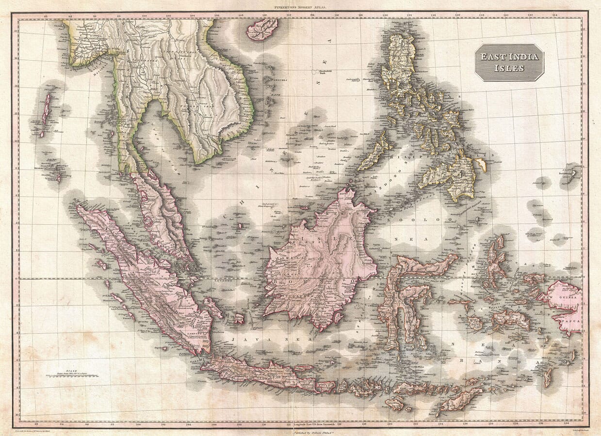
John Pinkerton’s East India Isles was drawn by L. Hebert and engraved by Samuel John Neele. The plate was first issued in London on 15 April 1813 and subsequently appeared in the American edition of Pinkerton’s Modern Atlas, published by Thomas Dobson in Philadelphia in 1818.
Map Details
- Original title: East India Isles
- Cartographic direction: John Pinkerton
- Drawn by: L. Hebert
- Engraver: Samuel John Neele
- Plate first issued: London, 15 April 1813
- Edition reproduced: Thomas Dobson edition
- Published: Philadelphia, 1818
- Atlas: A Modern Atlas, from the Latest and Best Authorities
- Approximate scale: 1:7,200,000
- Coverage: Mainland Southeast Asia, the Malay Archipelago, the Philippines and western New Guinea
- Relief: Mountain ranges represented by hachures
- Format: Copperplate engraving with hand colouring
Sincapoor Before the British Trading Settlement
At the southern end of the Malay Peninsula, Pinkerton identifies the island of Singapore as Sincapoor. The Philadelphia edition appeared in 1818, one year before Sir Stamford Raffles established the British East India Company’s trading settlement there.
The name was therefore not a new British invention. It identifies an island and settlement already known within much older regional trading networks. Its relatively modest appearance on the map provides a striking contrast with the international port that Singapore would soon become.
Malacca is more prominent, reflecting its established importance beside the narrow strait connecting the Indian Ocean with the South China Sea. The close concentration of names around the Malay Peninsula demonstrates the commercial and navigational importance of these waters.
Detailed Coasts and Uncertain Interiors
The map reveals how geographical information was accumulated. Java and Sumatra contain numerous settlements, rivers, mountain ranges and written observations. Coastal Borneo is also carefully named, particularly around river mouths and trading locations.
Knowledge becomes less certain inland. In parts of Borneo and New Guinea, extensive geographical detail gives way to isolated descriptions such as “Fresh Water” or “Lava”. These are not merely empty spaces: they show where European mapmakers possessed fragments of information but lacked a continuous survey.
The contrast is valuable because it makes the map a record of knowledge as well as geography. Sea routes and accessible coasts were documented far more confidently than forests, mountains and communities beyond regular maritime contact.
Java, Sumatra and Rakama
Java and Sumatra extend across the southern part of the engraving. Their volcanic mountain chains are represented with dense hachures, while towns, plantations, rivers and coastal features fill the surrounding land.
Within the Sunda Strait, Pinkerton names an island as Rakama. This represents Rakata, part of the Krakatoa volcanic group. The name acquired far greater international recognition after the catastrophic eruption of 1883, more than sixty years after this edition was published.
Its presence provides a particularly tangible connection between the early map and a later event that transformed both the island group and surrounding coastline.
The Philippines and the Eastern Islands
The Philippines occupy the northeastern portion of the map. Luzon, Mindanao, Palawan and numerous smaller islands are individually delineated, with Manila clearly identified on Luzon.
Farther south, the branching outline of Celebes—now Sulawesi—forms one of the map’s most recognisable shapes. The Moluccas or Maluku Islands lie to the east, scattered across waters historically associated with the trade in cloves, nutmeg and mace.
Timor and its neighbouring islands lead towards the western coast of New Guinea. The eastern extent of New Guinea falls beyond the engraved border, making the plate a focused representation of the East Indies rather than a general map of the Pacific.
Historic Names on the Map
Many names differ from modern usage. Burma broadly corresponds to Myanmar, Siam to Thailand, Celebes to Sulawesi and the Moluccas to Maluku. Cochinchina was used for part of what is now Vietnam.
Other names remain familiar: Java, Sumatra, Borneo, Manila, Bangkok and Malacca can all be located readily. These surviving and altered names make the map especially rewarding for viewers with personal, family or historical connections to Southeast Asia.
Pinkerton’s map does not simply portray a large collection of islands. Through Sincapoor, Rakama, its detailed trading coasts and uncertain interiors, it preserves a particular moment in the developing European understanding of the region.





 Verified owner












