
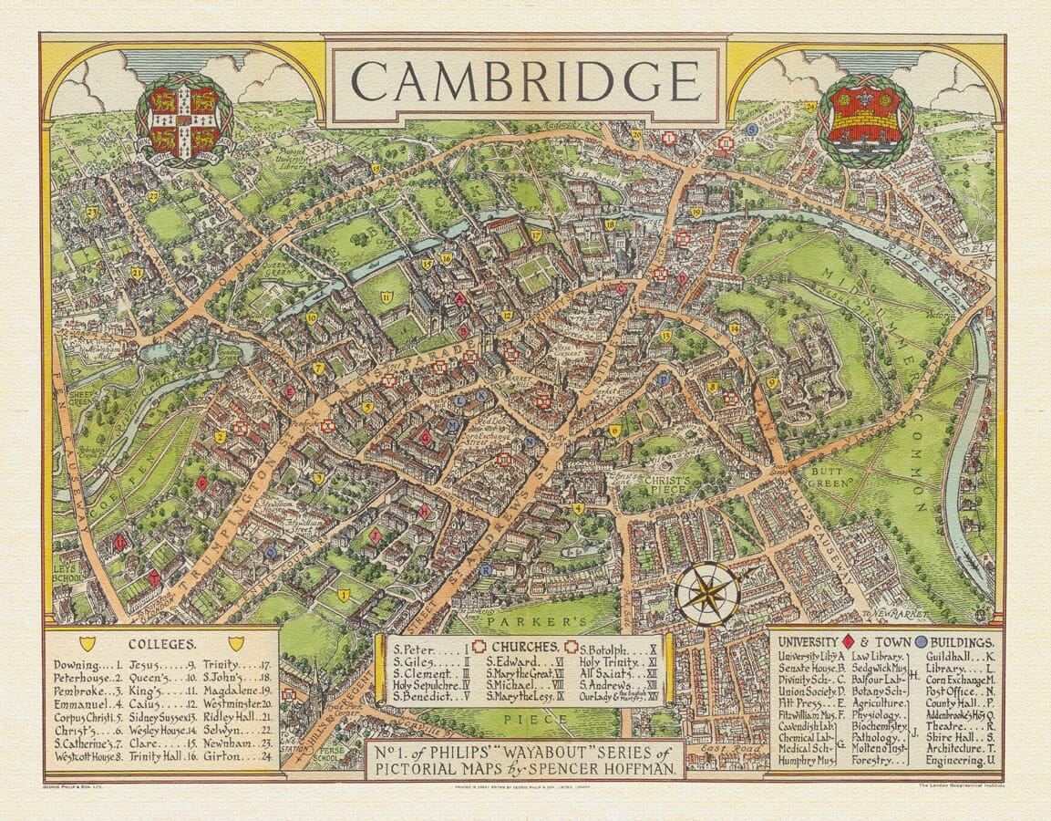



Pictorial old map of Cambridge by Spencer G. Hoffman showing the university colleges
Pictorial old map of Cambridge by Spencer G. Hoffman showing the university colleges Cambridge Town Plan Detail Cambridge Town Plan Cambridge Town Plan

Old Map of Cambridge

Price range: £35.55 through £59.95

Old Map of Cambridge by Spencer G. Hoffman, 1929

A richly illustrated pictorial map of Cambridge, originally published as the first in Philip’s “Wayabout” series. The university colleges, River Cam, the Backs, churches, greens and historic city streets are presented through colourful period artwork.

Faithfully reproduced as a fine-art archival pigment print on textured paper and supplied unframed, this decorative Cambridge map makes an excellent graduation, alumni or university gift.
+ read more

A stunning certified FINE ART PRINT on heavy textured art paper — not a poster

  • Direct from the publisher — no middlemen
  • Printed in-house in Cornwall
  • Free UK delivery — international shipping available
  • Produced to meet — and often exceed — museum-quality standards

SELECT SIZE

Inspecting Vintage Map Reproduction

Fine Art Map Reproductions – Museum-Quality Printing

Unlike most online offerings, our maps are produced entirely in-house, not outsourced to print-on-demand or drop-shipping services. This allows complete control over quality while offering better value. Each map begins with a high-resolution original, carefully enhanced and printed to order using archival papers and pigment inks for exceptional clarity, depth, and longevity. Every piece is personally overseen — no map leaves our workshop unless it is of a quality we would be proud to display ourselves.

Hand hold a magnifying glass over West Cornwall Map

Authentic Old Map Paper & Accurate Colour Reproduction

Paper choice is essential to the authenticity of our maps. We use specially sourced 190gsm paper made in the UK from pure materials and traditionally pressed with natural woollen felts. This process creates a subtle, randomly textured surface that closely resembles an original antique document. Likewise the use of premium quality ink fully saturates the paper, producing remarkable clarity, depth, and historical character. Colour fastness and sharpness will remain good for in excess of 100 years!

Map in Postal Tube
Buy Old Maps Online in the UK Today Trading online since 1999

The Old Map Company of Great Britain offers a vast and carefully curated collection of the very finest expertly reproduced vintage maps. Our range includes works by renowned cartographers such as John Speed and Willem Blaeu, covering Scotland, England, and beyond. Free UK courier delivery is included, with EU, USA, and worldwide shipping available at cost and calculated at checkout. If you need assistance, our team is always happy to help you choose the perfect map.

RECENT REVIEWS

Daz
DazGB
Verified ownerVerified owner
5/5

Speedy delivery A beautiful representation

2 months ago
David H
David H
Verified ownerVerified owner
5/5

Got there in time and loves it! Cheers David [Gift from US to UK]

4 months ago
Ellan C-S
Ellan C-S
Verified ownerVerified owner
5/5

Thanks Lauren. We received it today - it's gorgeous! Thank you, Ellan

4 months ago
Ivano Di Battista
Ivano Di Battista
Verified ownerVerified owner
5/5

Thank you for your prompt service. I have a gallery and framing business in South Wales. I'm so pleased it is printed in the UK

5 months ago
Robert B
Robert B
Verified ownerVerified owner
5/5

My Isles of Scilly map arrived safely and I'm delighted with it!

5 months ago
Andrew T
Andrew T
Reviewer
5/5

The print arrived safely and we're delighted with it - a lovely reminder of our honeymoon 15 years ago.

5 months ago
Hannah J
Hannah J
Verified ownerVerified owner
5/5

I have just received them! I'm sure our clients will be pleased with them and there could be more projects off the back of this one where we can use more. [Interior Designers]

5 months ago
Sean MacManus
Sean MacManus
Verified ownerVerified owner
5/5

I just received my map of Ireland by Ewart today and, as usual, I am delighted by its quality. The crispness and fineness of detail is excellent and the colour reproduction surpasses my expectations. Please relay my thanks to Steve for another fine effort!

6 months ago
John G
John G
Verified ownerVerified owner
5/5

Many thanks, Lauren. Very pleased with the map and the service: would recommend The Old Map Company to anyone interested in Old Maps.

8 months ago
Lois K
Lois K
Verified ownerVerified owner
5/5

Thrilled , Lauren! Thank You

8 months ago
Ed Simpson
Ed Simpson
Verified ownerVerified owner
5/5

Many thanks, the map arrived safely this morning, and I’m really pleased with it. A stunning reproduction, just as I had hoped. I will keep browsing your website, and may yet be tempted by more of your items! Have a great weekend.

8 months ago
Daniel McCade
Daniel McCade
Verified ownerVerified owner
5/5

Just arrived, wonderful map! Thanks very much!

9 months ago
Jonathon R
Jonathon R
Verified ownerVerified owner
5/5

The map – beautiful – arrived safely, very many thanks.

1 year ago
Rasa Terbetiene
Rasa Terbetiene
Verified ownerVerified owner
5/5

Thank you, I have already found the map. It’s wonderfull! Good luck! Rasa

4 years ago
Mina M.
Mina M.
Verified ownerVerified owner
5/5

My apologies for the very late reply. I wanted to reach out to thank you so much for rushing my order. My partner absolutely loved it. I am amazed with the service so that is a five-star from me. I wish you all the best.


4 years ago

Produced in 1929, this colourful old map of Cambridge was drawn by Spencer G. Hoffman and published by George Philip & Son. It was the first map in Philip’s distinctive “Wayabout” series of pictorial maps, which combined practical visitor information with lively illustrations of notable buildings and local landmarks.

Map Details

  • Original title: Cambridge
  • Mapmaker: Spencer G. Hoffman
  • Publisher: George Philip & Son Ltd, London
  • Date: 1929
  • Series: No. 1 of Philip’s “Wayabout” Series of Pictorial Maps
  • Format: Colour pictorial town plan
  • Coverage: Central Cambridge, the university colleges and surrounding neighbourhoods

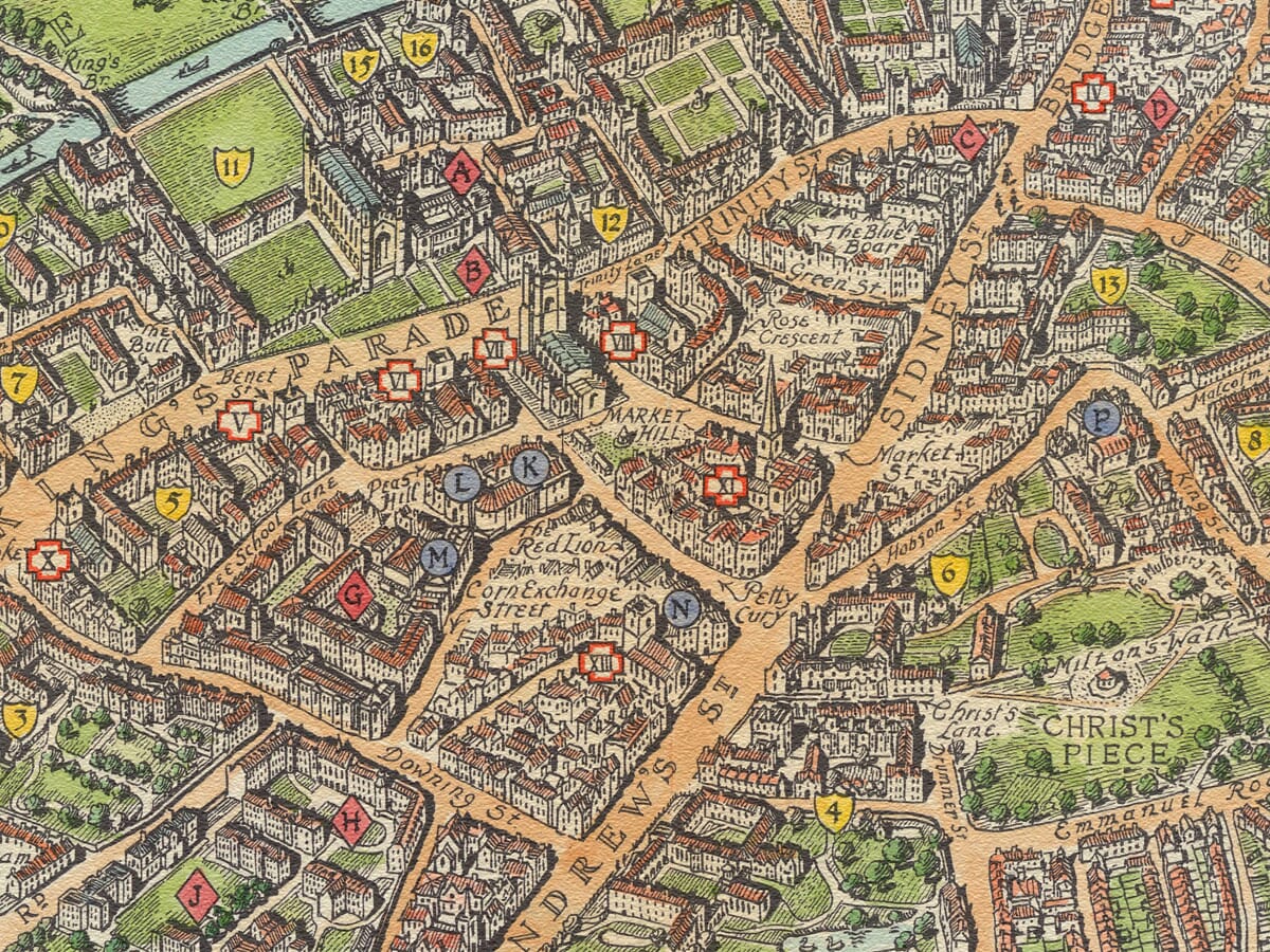
The historic centre of Cambridge is presented as an engaging bird’s-eye plan rather than a strictly measured street map. Buildings are enlarged and illustrated individually, helping visitors recognise the university’s colleges, churches and principal civic landmarks.

Cambridge’s colleges are identified by numbered shield symbols linked to the key beneath the map. The plan includes many of the university’s best-known institutions, including King’s, Trinity, St John’s, Queens’, Jesus, Peterhouse, Pembroke, Christ’s and Emmanuel colleges.

The River Cam winds through the western side of the city, passing the colleges and landscaped grounds now collectively known as the Backs. Jesus Green, Midsummer Common and Parker’s Piece provide prominent open spaces among the closely packed streets and university buildings.

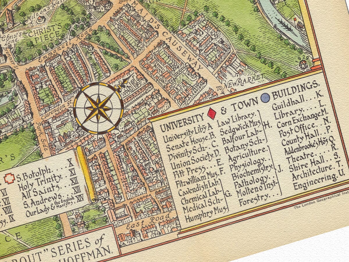
Separate references identify Cambridge’s churches and important university and town buildings. The railway station, main routes into the city and roads leading towards nearby settlements are also shown, making the map useful to the contemporary visitor while retaining a strongly decorative character.

Two coats of arms crown the design, while a compass rose, hand-lettered place names and individually drawn buildings give the map its distinctive period appearance. Hoffman’s illustrations capture Cambridge at the end of the 1920s, when pictorial maps were becoming popular as attractive and accessible guides for tourists.

Because the map was designed to entertain and inform, its scale and perspective are intentionally flexible. Streets, colleges and landmarks are arranged for clarity and visual interest rather than precise navigation. The result is an appealing portrait of interwar Cambridge and a particularly suitable gift for graduates, alumni, residents and admirers of the university city.

You may also like…

×
Product added to cart
No products in the cart.


