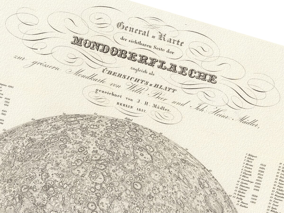
old map of moon
old map of moon old map of moon detail old map of moon detail

The Moon

Price range: £29.95 through £59.95

An Old Map of the Moon

A fascinating chart of the lunar surface by Wilheim Beer and John Heinrich Madler. Engraved in Berlin during 1837 by E. Leidenfrost. Early moon maps are somewhat rare and we love this detailed depiction which surely represents an extraordinary piece of wall art that will go to create a conversation point wherever it is displayed.
+ read more

A stunning certified FINE ART PRINT on heavy textured art paper — not a poster

  • Direct from the publisher — no middlemen
  • Printed in-house in Cornwall
  • Free UK delivery — international shipping available
  • Produced to meet — and often exceed — museum-quality standards

SELECT SIZE

Inspecting Vintage Map Reproduction

Fine Art Map Reproductions – Museum-Quality Printing

Unlike most online offerings, our maps are produced entirely in-house, not outsourced to print-on-demand or drop-shipping services. This allows complete control over quality while offering better value. Each map begins with a high-resolution original, carefully enhanced and printed to order using archival papers and pigment inks for exceptional clarity, depth, and longevity. Every piece is personally overseen — no map leaves our workshop unless it is of a quality we would be proud to display ourselves.

Hand hold a magnifying glass over West Cornwall Map

Authentic Old Map Paper & Accurate Colour Reproduction

Paper choice is essential to the authenticity of our maps. We use specially sourced 190gsm paper made in the UK from pure materials and traditionally pressed with natural woollen felts. This process creates a subtle, randomly textured surface that closely resembles an original antique document. Likewise the use of premium quality ink fully saturates the paper, producing remarkable clarity, depth, and historical character. Colour fastness and sharpness will remain good for in excess of 100 years!

Map in Postal Tube
Buy Old Maps Online in the UK Today Trading online since 1999

The Old Map Company of Great Britain offers a vast and carefully curated collection of the very finest expertly reproduced vintage maps. Our range includes works by renowned cartographers such as John Speed and Willem Blaeu, covering Scotland, England, and beyond. Free UK courier delivery is included, with EU, USA, and worldwide shipping available at cost and calculated at checkout. If you need assistance, our team is always happy to help you choose the perfect map.

RECENT REVIEWS

David H
David H
Verified ownerVerified owner
5/5

Got there in time and loves it! Cheers David [Gift from US to UK]

1 month ago
Ellan C-S
Ellan C-S
Verified ownerVerified owner
5/5

Thanks Lauren. We received it today - it's gorgeous! Thank you, Ellan

1 month ago
Ivano Di Battista
Ivano Di Battista
Verified ownerVerified owner
5/5

Thank you for your prompt service. I have a gallery and framing business in South Wales. I'm so pleased it is printed in the UK

2 months ago
Robert B
Robert B
Verified ownerVerified owner
5/5

My Isles of Scilly map arrived safely and I'm delighted with it!

2 months ago
Andrew T
Andrew T
Reviewer
5/5

The print arrived safely and we're delighted with it - a lovely reminder of our honeymoon 15 years ago.

2 months ago
Hannah J
Hannah J
Verified ownerVerified owner
5/5

I have just received them! I'm sure our clients will be pleased with them and there could be more projects off the back of this one where we can use more. [Interior Designers]

2 months ago
Sean MacManus
Sean MacManus
Verified ownerVerified owner
5/5

I just received my map of Ireland by Ewart today and, as usual, I am delighted by its quality. The crispness and fineness of detail is excellent and the colour reproduction surpasses my expectations. Please relay my thanks to Steve for another fine effort!

3 months ago
John G
John G
Verified ownerVerified owner
5/5

Many thanks, Lauren. Very pleased with the map and the service: would recommend The Old Map Company to anyone interested in Old Maps.

4 months ago
Lois K
Lois K
Verified ownerVerified owner
5/5

Thrilled , Lauren! Thank You

5 months ago
Ed Simpson
Ed Simpson
Verified ownerVerified owner
5/5

Many thanks, the map arrived safely this morning, and I’m really pleased with it. A stunning reproduction, just as I had hoped. I will keep browsing your website, and may yet be tempted by more of your items! Have a great weekend.

5 months ago
Daniel McCade
Daniel McCade
Verified ownerVerified owner
5/5

Just arrived, wonderful map! Thanks very much!

6 months ago
Jonathon R
Jonathon R
Verified ownerVerified owner
5/5

The map – beautiful – arrived safely, very many thanks.

12 months ago
Rasa Terbetiene
Rasa Terbetiene
Verified ownerVerified owner
5/5

Thank you, I have already found the map. It’s wonderfull! Good luck! Rasa

3 years ago
Mina M.
Mina M.
Verified ownerVerified owner
5/5

My apologies for the very late reply. I wanted to reach out to thank you so much for rushing my order. My partner absolutely loved it. I am amazed with the service so that is a five-star from me. I wish you all the best.

3 years ago
We’ve transcribed the text from the panel at the base of this fine old chart which is in German with a translation into English following . . .

Erläuterungen.

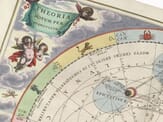
Die sichtbare Oberfläche unseres Nebenplaneten in einer naturgetreuen, leicht und allgemein verständlichen, und zugleich bequem übersichtlichen Darstellung zu geben, ist der Zweck die- ser Karte, die ich aus den Originalzeichnungen zu einer grössern Mondkarte selbst redigirt und gezeichnet, nach einzelnen Verbesserungen, welche durch spätere Beobachtungen erhalten worden sind, so viel der Maasstab es gestattet, darauf angebracht habe. – Wir unterscheiden am Monde direct nichts weiter, als Unterschiede des Niveaus und des Lichtglanzes, also Mondberge und Mondflächen. Erstere zeigen sich am besten bei zu- und abnehmendem Monde, wenn die zu beobachtende Gegend der Lichtgrenze nahe liegt, letztere am vollstän- digsten im Vollmonde, beide aber muss man um sie recht darzustellen, in allen Lagen wiederholt beobachten und zeichnen. Die Berge erscheinen auf dem Monde meistens als Ringe od. Wälle, die nach innen oft sehr steil und tief abstürzen, und eine basaltartige Vertiefung (Krater) einschliessen. Viele dieser Ringgebirge sind nach dem Namen von berühmten Gelehr- ten bezeichnet, die hier am Rande so wie jedes der vier Quadranten verzeichnet sind. Ausser derselben hat die Tiefe, in der die Fläche vom Walle nach innen, nach unserm eignen Maasstabe in Par. Fuss angegeben, einen axialen Vulkan daneben, wo bezeichnet, der nie über die äussere Umgebung. – Doch zeigen sich auch wirkliche Bergketten wie auf unserm Erde, die nur durch Namen erläutert und auf der Karte selbst angegeben sind. – Die meisten der kleineren Vertiefungen kommen, ihrer geringen Grösse wegen, nicht auf durch Bergstriche angedeutet werden, etwa ihrer Kreise angezeigt werden, so wie für die strahlen Fliuren (Rillen) die sich in verschie- nen Gegenden der Mondfläche zeigen, enge Parallellinien. Flache Landstrecken oder sogenannte Beyraden sind gleichfalls sehr häufig, meist minder einzelne Gipfel, unter denen sich namentlich die Centralberge im Innern der Ringgebirge auszeichnen.

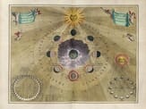
Die Mondfarbe könnte hier nur in ihren allgemeinen Umrissen angedeutet werden, da sie nur in einer gesonderten Darstellung vollständig und naturgetreu gegeben werden könnte. Man kann wenigstens zehn verschiedene Abstufungen vom Dunkelgrau bis zum lühenenden Weiss aufstellen. Gewöhnlich ist der Berg das Hellere, und die Niederung das Dunkle, oft aber zeigt es sich auch umgekehrt, und namentlich gehören die hellern Flecke auf dem Monde fast nie den höhern Bergen an, sondern reize Tiefen, selbst heil glänzen. Die gro- sseren grauen Flecke sind schon dem blossem Auge sichtbar und früher herkömmlich Meere genannt worden, obgleich sie keine Wasserbecken, vielmehr einen trockenliegenden, wüsten Boden zeigen. Die von sichtbaren Halbigkeit ist übrigens so dargestellt, wie sie in mittleren Lage des Mondes (der sogenannten mittleren Libririon im astro- nomischen Fernrohr vor uns haben. Nur die Mittellandshafen erscheinen also hier in etwas nördlicherer wirklichem Verhältniss; näher den Ländern zu werden z. B. alle Kreise läng- tich gefunden. Für den Abdruck im terrestrischen Fernrohr oder mit freiem Auge müssen also das Blatt umkehren müssen. 
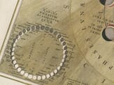
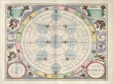
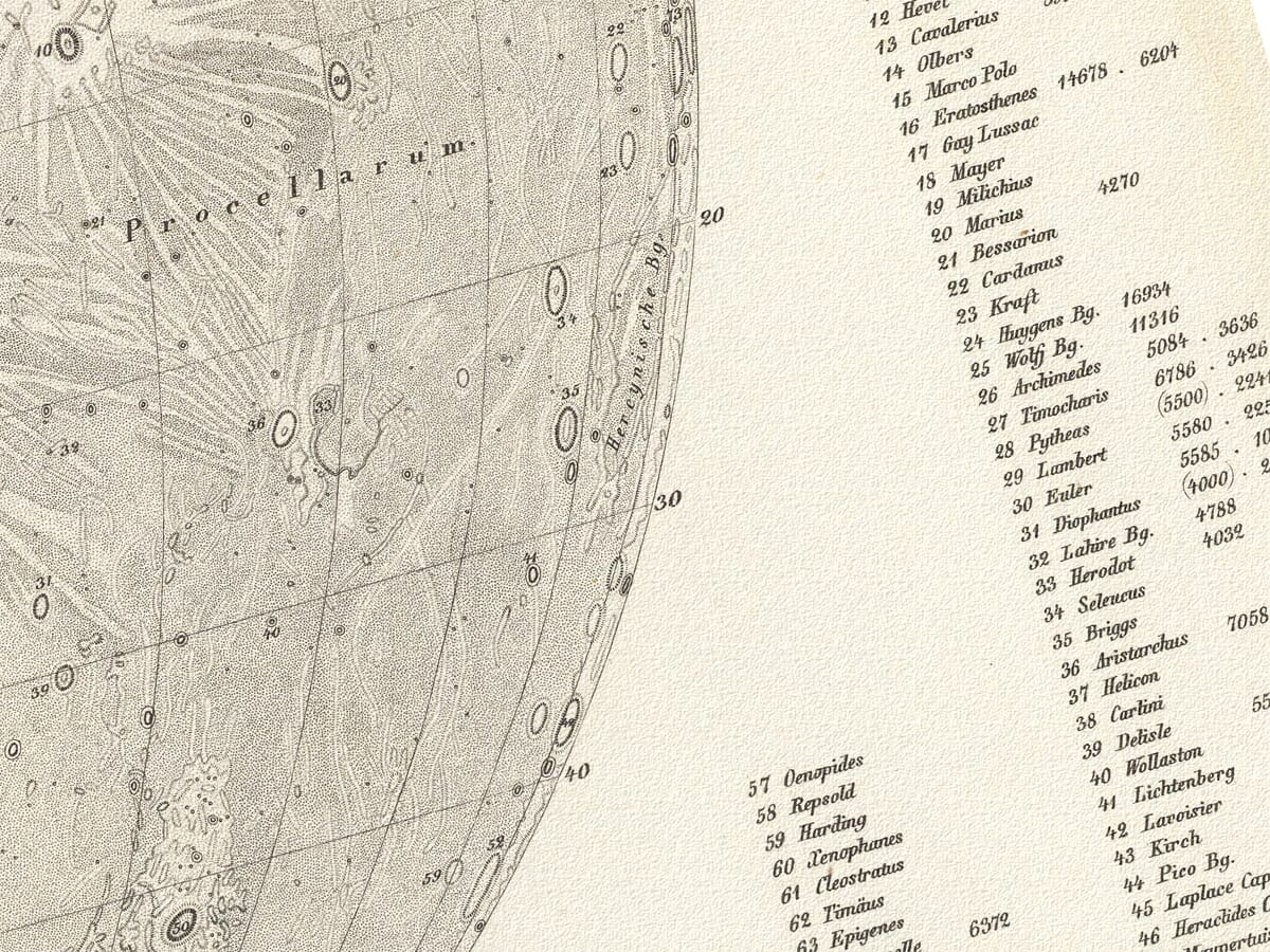
Das Gradnetz ist nach demselben Grundsatze wie bei einer Erdkarte entworfen. Vom adäquaten nach beiden Polen hin zählen 90 Breiten, und vom mittlern Meridian nach bei- den Seiten 90 Längengrade. Jeder Grad des Mondumfangs beträgt 15 Meilen. Der Durchmesser der Mondkugel beträgt 468 Meilen, ihr Umfang 1401 1/2 Meilen, sie ist nach ihrer Oberfläche 1/13 mal, nach ihrem körperlichen Inhalte 1/49 mal kleiner als unsere Erde. Man kann also den Durchmesser des Mondes etwa mit der ten I nach 5 gegrössten Breite des europäischen Festlandes, den Umfang mit der grössten Länge Amerikas vergleichen.
J. H. Mädler.


Explanations.

The purpose of this map—which I edited and drew myself from the original sketches to create a larger lunar map—is to present the visible surface of our satellite in a lifelike, clear, and generally understandable manner, while also keeping the depiction conveniently organized. Later observations have provided certain improvements, which I have included here as far as the scale allows.

On the Moon we perceive directly nothing more than differences of elevation and brightness: that is, lunar mountains and plains. The former are best observed when the Moon is waxing or waning, when the region under observation lies near the line between light and dark; the latter are most fully seen at full moon. To portray both accurately, they must be observed and drawn repeatedly in every phase.

The mountains of the Moon mostly appear as rings or walls that often descend steeply and deeply inward, enclosing a basalt-like depression (a crater). Many of these ring-shaped mountain ranges are named after famous scholars; these names are marked on the margins and within each of the four quadrants. Besides these, the depth of the floor within the wall is given, in Paris feet according to our own measurements, and where indicated an axial “volcano,” though it never rises above the outer surroundings.

True mountain chains, like those on our Earth, also appear and are explained by names and noted on the map itself. Most of the smaller depressions, owing to their small size, cannot be shown by shading and are instead indicated by small circles, as are the narrow furrows (rilles) that appear in various regions of the lunar surface and are drawn as fine parallel lines. Flat land areas or so-called “bays” are likewise frequent, usually with fewer isolated peaks, among which the central mountains inside the ring ranges are particularly noteworthy.

The Moon’s color can only be hinted at here in its general outlines, for it could be rendered fully and faithfully only in a separate depiction. One can distinguish at least ten different gradations from dark gray to shining white. Usually the mountains are lighter and the lowlands darker, though the reverse sometimes occurs, and the bright spots on the Moon almost never belong to higher mountains but often to low areas that gleam brilliantly. The larger gray spots are visible to the naked eye and were traditionally called “seas,” although they are not bodies of water but rather dry, barren ground.

The visible hemisphere is shown as it appears in the telescope when the Moon is in its mean position (the so-called mean libration). Only the central latitudes thus appear slightly farther north than in reality; for comparison with the view in a terrestrial telescope or to the unaided eye, the sheet must be reversed.

The grid of latitude and longitude is drawn on the same principle as that of an Earth map. From the equator to each pole there are 90 degrees of latitude, and from the central meridian 90 degrees of longitude to each side. Each degree of the Moon’s circumference measures 15 miles. The diameter of the lunar globe is 468 miles, its circumference 1,401½ miles. By surface area it is about 1/13 the size of the Earth, and by volume about 1/49. The Moon’s diameter may therefore be compared to the greatest breadth of the European continent, and its circumference to the greatest length of the Americas.

J. H. Mädler

You may also like…

  • Star Map 19 Detail 1Star Map 19Add to Basket This product has multiple variants. The options may be chosen on the product page

    Moon and Sun Map (19)

    Price range: £29.95 through £59.95
  • Star Map 18 Detail 1Star Map 18Add to Basket This product has multiple variants. The options may be chosen on the product page

    Old Lunar Map (18)

    Price range: £29.95 through £59.95
×
Product added to cart
No products in the cart.