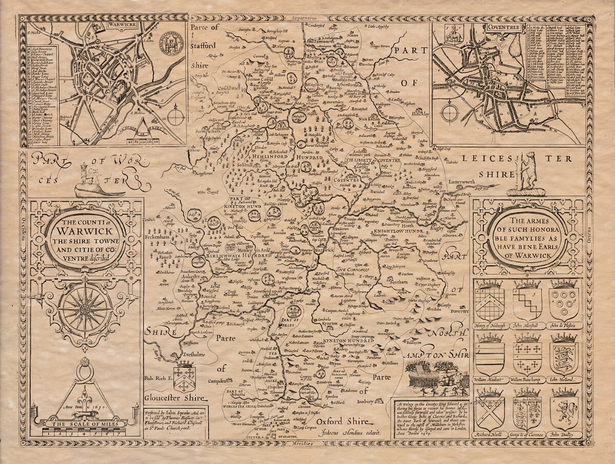
John Speed added a short essay which was published on the rear (the verso) of his old map of Warwickshire which we have translated into modern English . . .
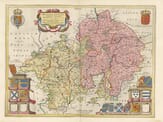
Warwickshire (named after its county town) is bordered to the north by Staffordshire, to the east by the Watling Street, separating it from Leicestershire, and to the rest by Northamptonshire. To the south, it borders Oxfordshire and Gloucestershire, and to the west, it is bordered by Worcestershire.
The shape of the county resembles a scallop shell, starting narrow at its western edge and widening as it spreads out with many indentations. The length of the county from Newton in the north to Long-Compton in the south is 33 miles, and its widest part stretches from Hewel Grange in the west to Hill Morton in the east, a distance of 25 miles. The entire circumference is approximately 135 miles.
This county is located near the center of England and shares the best climate and soil, offering both profit and pleasure to its people. The southern part, known as the Feldon, lies along the Avon River and is more open and suitable for growing corn, which produces such bountiful harvests that farmers are often pleased with their work. The meadows, lush with grass and flowers, resemble another Eden, as seen from Edge Hill, much like Lot’s view of the Plain of Jordan before the destruction of Sodom. The northern part of the county, known as the Woodland, was once rich in forests but is now less so due to ironworking, making the soil less fertile for farming.
The ancient inhabitants of this area were known as the Cornavii, and later, the Saxons, particularly the Mercians, settled here. The region was much contested by the West Saxons. In 749, King Cuthred of Wessex defeated King Ethelbald of Mercia at Seckington. Nearby, King Edward IV famously fought against Richard Neville, Earl of Warwick. The famous battle took place at Blacklow Hill, where the proud Earl of Cornwall, Pierce Gaveston, was executed by Guy, the Earl of Warwick, aided by the Earls of Lancaster and Hereford. Over the centuries, the county’s towns suffered from depopulation, particularly due to the grazing of sheep.
However, Warwickshire boasts many beautiful towns, some of which are among the finest in England. The chief town is Coventry, a city renowned for its impressive buildings and strong city walls. The citizens of Coventry once angered their lord, Leofric, who imposed heavy taxes on them. His wife, Lady Godiva, pitying the citizens’ plight, interceded on their behalf, eventually securing the removal of the heavy taxes. As a condition, she was required to ride through the city naked at noon. Lady Godiva, covering herself with her long hair, rode through the streets, and the citizens’ freedoms were restored. The city remembers her to this day with honor.
Coventry was granted the right to elect its magistrates, including a mayor and two bailiffs, and to build city walls under King Edward III. Henry VI later made it a separate county, and the title of Bailiff was changed to Sheriff. The city walls, which still stand, have 13 gates and 18 towers for defense. At the east gate, there hangs a large wild boar’s tusk, believed to have been killed by Guy of Warwick.
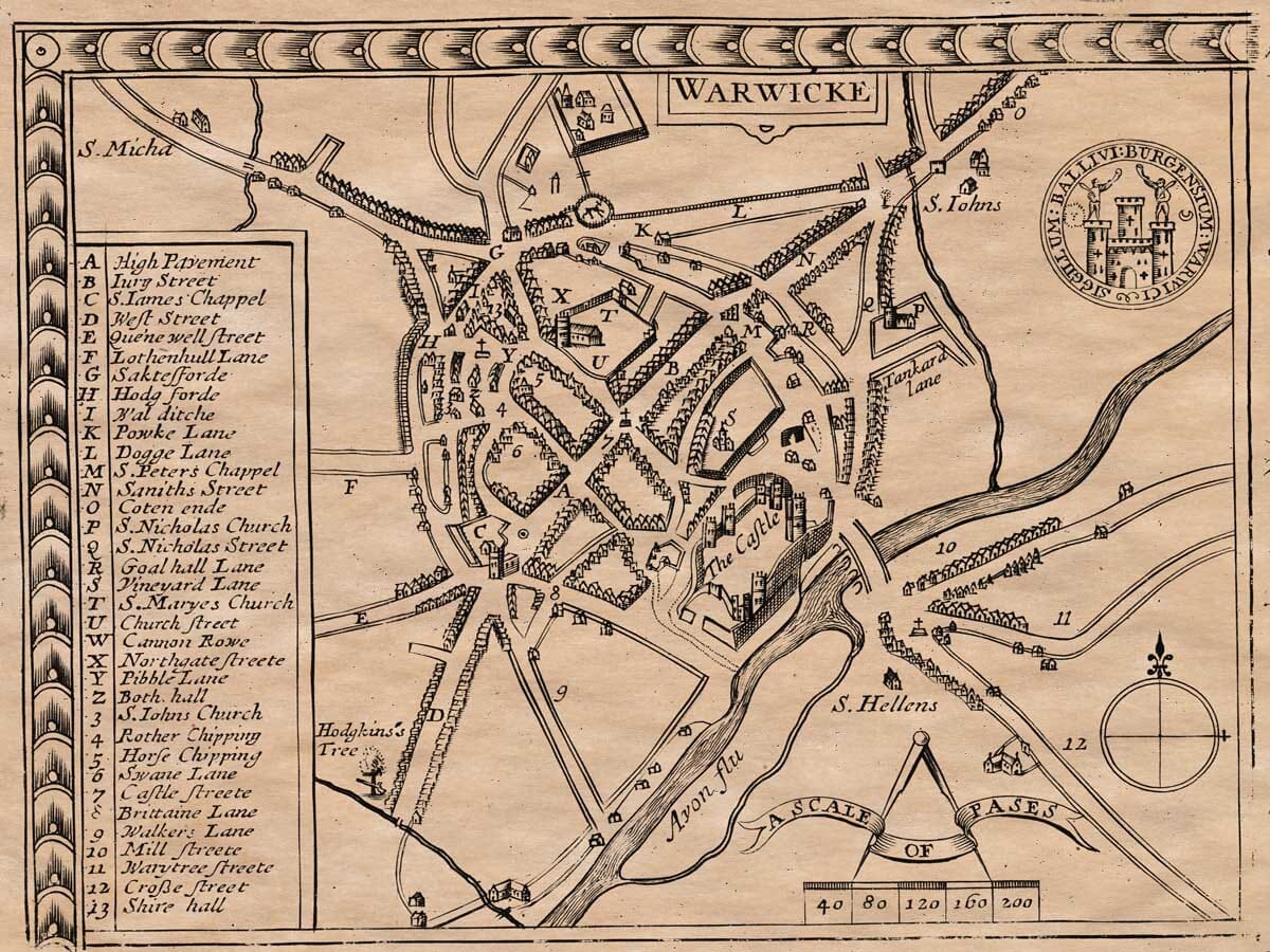
Next in importance is the town of Warwick, located on the northwest bank of the River Avon. The town was founded by Gurgunftus, the son of Belinus, around 375 years before Christ, according to John Roffe, a local monk. It has been known by various names over the centuries, including Caer-Guarvic and Caer-Leon. The town’s position is scenic, sitting on a hill above the river, with a strong stone bridge and an impressive castle. The castle has been extensively repaired by the noble Sir Foulke Grivel, a man known for his virtue and nobility.
Warwick was once walled, and traces of the old walls remain, along with two large gates carved from rock. Two chapels stand over these gates: St. Peter’s to the east and St. James’ to the southwest. The town also has two notable churches, St. Mary’s and St. Nicholas, though several other churches in the area, such as St. Lawrence and St. Michael’s, have been suppressed over time. The town is governed by a bailiff, twelve brethren, twenty-four burgesses for the common council, a recorder, a town clerk, and a sergeant-at-arms.
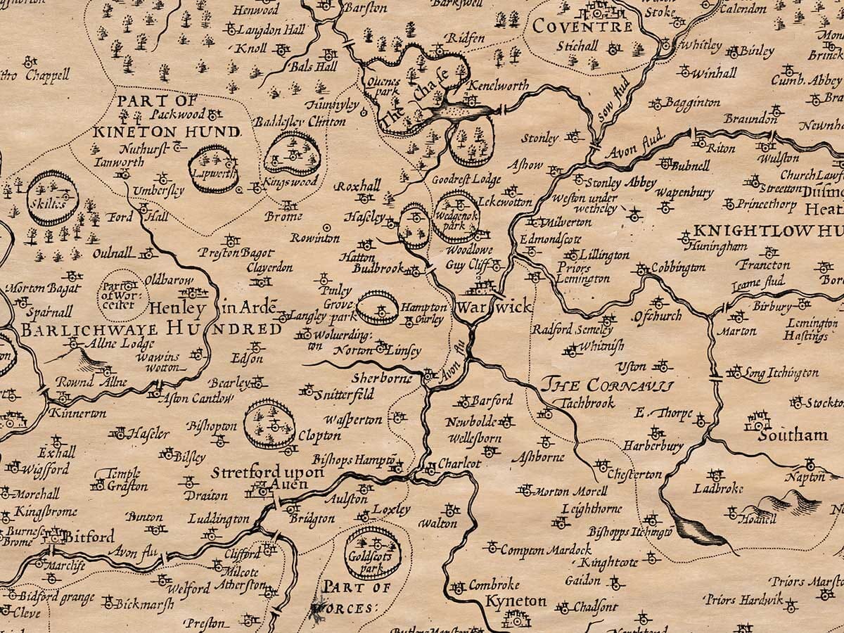
Other noteworthy places in the county include Shugborough, where the precious stone Astroites is found; Of-Church, once the palace of the Mercian King Offa; and Chesterton, where the famous Fosse Way can be seen. Leamington, despite being far from the sea, has a spring of saltwater. At Newenham Regis, there is a miraculous spring that can cure various ailments, such as kidney stones and ulcers. Guy Cliff is the site where the famous Earl Guy, after many adventures, retired to live a hermit’s life and was eventually buried.
The county is abundant in corn, particularly in the Redhorse Vale, and is also known for its wool, wood, and iron, though iron production has depleted many of the woods. Some notable families have held the title of Earl of Warwickshire since the Norman Conquest. The county is home to eight strong castles, 18 market towns, and many fine buildings, as well as numerous monasteries, including those at Stonely, Warwick, Thelford, and Coventry. Most of these monasteries were disbanded during the reign of Henry VIII, and their wealth was seized for his use. However, there are still 158 parish churches scattered throughout the county.