The historical text on the verso of the map . . .
Nobly hath resolved, that the whole
Isle of Britaine was divided into three
parts, the first and largest whereof
is named England; the second, Wales,
and the third, Scotland. This Country
of Wales, which in the British tongue is called
Cambria, the English Saxons termed it Wealas,
that is, the Country of Strangers, and we
Englishmen at this day do call it Wales, as
it were a land of Foreigners, though in truth
the ancient Britons themselves were the very
natives of this Island, and we in respect of them
but strangers.
Wales therefore being anciently bounded, as before,
is in length from the South to the North, that is,
from the Point of Saint David’s Head to the farthest
limit of Flintshire, about one hundred and fifty miles,
and in breadth from West to East, that is, from the
Isle of Anglesey to the confines of Hereford,
about eighty miles.
The whole Country is exceeding mountainous, and
thereby the air somewhat sharp and piercing, but
wholesome and very healthful, so that the inhabitants
do for the most part live to great years.
It is divided into twelve Shires or Counties,
whereof six are in South-Wales and six in North-
Wales; to wit, in South-Wales these:
1. Glamorgan. 2. Caermarthen.
3. Pembroke. 4. Cardigan.
5. Brecknock. 6. Radnor.
And in North-Wales:
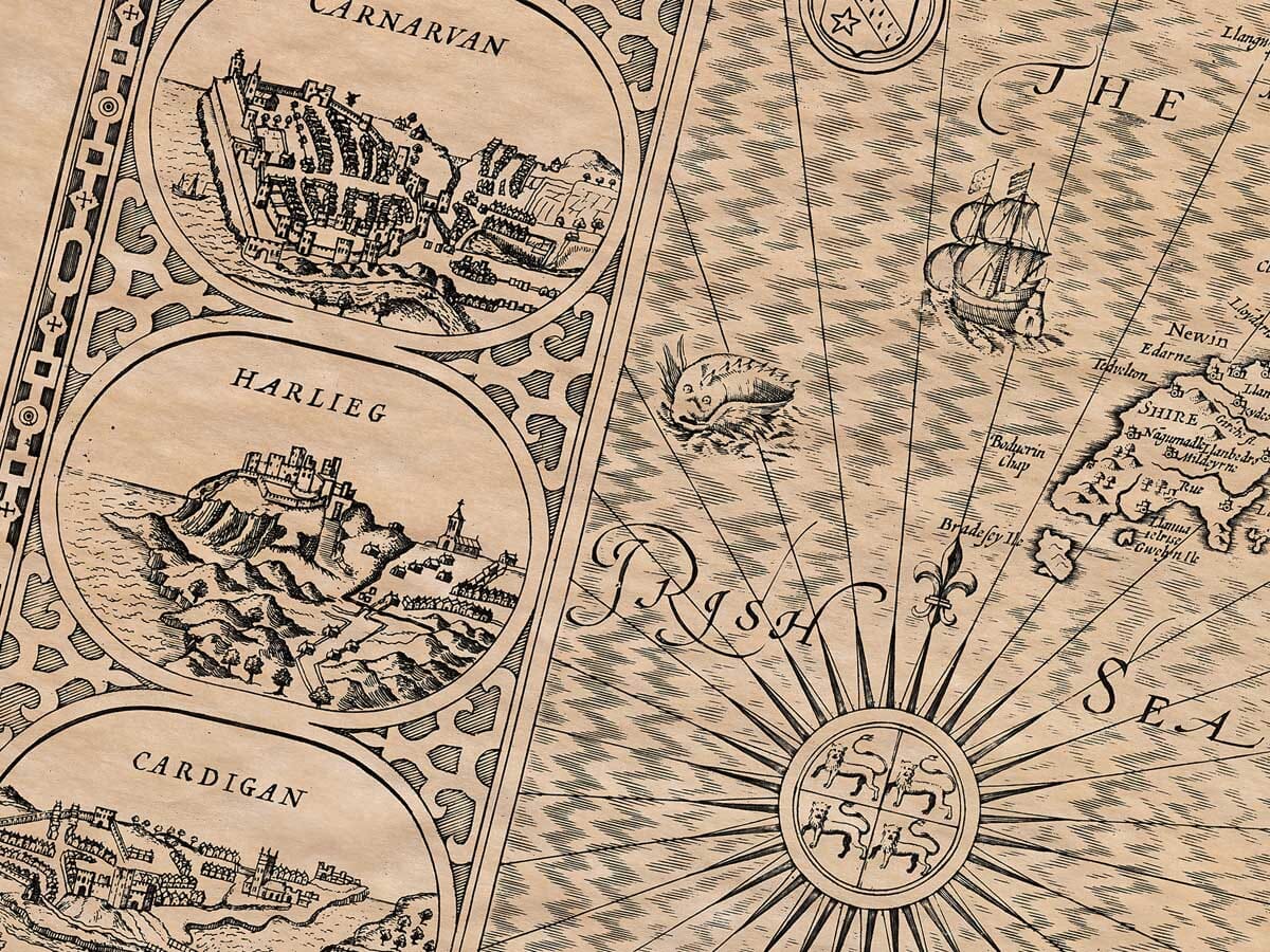
1. Anglesey. 2. Caernarvon.
3. Merioneth. 4. Denbigh.
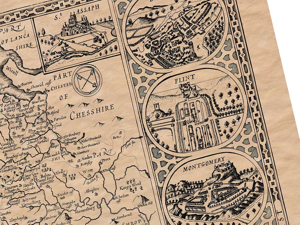
5. Flint. 6. Montgomery.
Each of these Counties is again parted into
Hundreds, and those into Parishes, as by the
ensuing Table is plainly set down.
[Table of the several Counties, their Hundreds, and Parishes,
set forth in columns as follows:]
Anglesey: 6 Hundreds, 62 Parishes
Caernarvon: 7 Hundreds, 68 Parishes
Merioneth: 6 Hundreds, 50 Parishes
Denbigh: 12 Hundreds, 57 Parishes
Flint: 6 Hundreds, 31 Parishes
Montgomery: 6 Hundreds, 47 Parishes
Glamorgan: 10 Hundreds, 121 Parishes
Caermarthen: 7 Hundreds, 98 Parishes
Pembroke: 7 Hundreds, 80 Parishes
Cardigan: 6 Hundreds, 61 Parishes
Brecknock: 6 Hundreds, 61 Parishes
Radnor: 6 Hundreds, 57 Parishes
And so the whole Principality of Wales consisteth
of Twelve Counties, Seventy-eight Hundreds, and
Seven Hundred and Eighty-three Parishes in all.
The notes on this old map of Wales continue . . .
To the East, the Marches of England, from Chester 10 myls, a little
above Elsmere. This part was in old time named Powys Fadog, Powys the
lesser, and by Sr. John Price divided into two parts. Powys Vadog is the
lower part, beginning from Chester, and running into the mid-land,
wherein stand the Towns of Holt, and the Castle of Chirke, with others.
It hath Cantreves and Commots as followeth:
1 Can. Y. Barwn. Cwm. Chirkeland,
Glyn Ebroys,
Idiernon. 8
2 Can. Y. Rhim. Cwm. Croesoswallt,
Mechain uwchcoed,
Mechain iscoed. 8
3 Can. Vwchimant. Cwm. Mochnant uwchcoed,
Mochnant iscoed. 7
4 Can. Trefed. Cwm. Trefed. 13
5 Can. Rhiodor. Cwm. Caereinion,
Ystradmarchel. 10
(13) The second part of Powys, or Powys Vadhan (the lesser
Powys), is Powys Wenwynwyn, and it stretcheth from the South part
of Shropshire as far as the river Tywy. In this are seated the towns
of Welshpool and Newton, and the Abbey of Strata Marcella, with
divers others. The Cantreves and Commots are these:
6 Can. Melienyd. Cwm. Lanydloes,
Ceri. 19
7 Can. Elfel. Cwm. Kevenllys,
Deuddwr,
Llannervyl. 15
8 Can. T. Clawd. Cwm. Swaithla,
Keven Clawd,
Ystrad Alun. 12
9 Can. Buellt. Cwm. Buellt,
Stredyevvyth,
Stradewy,
Hirnion. 23
(14) The third part belonging to South-Wales, is Radnor (Radnor-
shire), a wide barren room from Malvern hils to the river Wye,
a spacious Country full of Woods, Hills, and Rivers. In this part
is Radnor, with the Towns of Prestayn, New Radnor, Machinleth,
and others. The Cantreves and Commots are these:
10 Can. T. Ffwym. Cwm. Maelienydd,
Elvel. 17
11 Can. Swydd y. Cwm. Gwrtheyrnion,
Ceri. 8
12 Can. Llyswen. Cwm. Swydd y Glyn,
Swydd y Llyn. 14
13 Can. Cydwen. Cwm. Keven Clawd,
Hirnion. 9
This may suffice for the description of that which in old time
was called Powys land.
(15) Now we come next to describe the last Kingdom of
South-Wales, named Demetia, or Dyved, which in old time was
reckoned the greatest part, yea one of the best, because it was
more plentiful in corn and pasture, in cattle, and likewise
in fish of the sea and rivers, as in our times it is no less
fruitful. This was subdivided into six parts, which contained
Cantreves and Commots, as followeth:
1 Can. Penwedic. Cwm. Geneu’r glyn,
Creuddyn,
Anhuniog. 3
2 Can. Caunall. Cwm. Caunall,
Maeslough,
Llyswen. 8
3 Can. Cedid. Cwm. Troedy’r Rhiw,
Castell,
Gwinionydd. 10
4 Can. Ced. Cwm. Lleyn,
Evionydd. 11
5 Can. Penro. Cwm. Pebidiog,
Dewisland. 8
6 Can. Rhos. Cwm. Penrhyn,
Dyffryn. 19
7 Can. Pebiidawc.Cwm. Pebidiog,
Dewisland. 8
8 Can. Cemaes. Cwm. Cemaes,
Croyddin. 8
9 Can. Einior. Cwm. Einior,
Penfro. 18
(16) The third part is Cardigan, which is a Country
accounted the strongest part of all South-Wales, as that which is
defended with great Woods, and fair Rivers, divided into
three parts, as followeth:
10 Can. Phiniec. Cwm. Hirwin,
Swydd y ystrad. 12
11 Can. Eginoc. Cwm. Gwinionydd,
Creuddyn. 14
12 Can. Bychan. Cwm. Iscoed,
Uwchcoed. 18
13 Can. Maery. Cwm. Maery,
Hirwern,
Llandyssil. 43
(19) The fourth called Morganwg, or Glamorgan, both along
the Severn, and stretched thence Westward, from the river
Uske upon the West and North-West, even as far as the
South Sea, plentiful of Corn, Woods, and Rivers. In it are
Cantreves and Commots, as followeth:
Morganwg.
14 Can. S. Faes. Cwm. Rhoug,
Lanharran. 48
15 Can. Pen ychen.Cwm. Ebboth,
Glyn Rhondda. 23
16 Can. Brechnini. Cwm. Brechnini,
Cantref Bychan,
Hirwain. 35
17 Can. Gwenthlwg.Cwm. Gwent Iscoed,
Gwent Uwchcoed. 21
18 Can. Gwent Iscoed.Cwm. Ewyas,
Stradwen. 23
19 Can. Ifeod. Cwm. Glynn,
Byssog,
Uwchcoed,
Iffrem. 26
(21) The last is Brecknockshire, for the most part full of Moun-
tains, Woods, and Rivers. This Country is both strong and
plentiful, having plain Fields, Woods, and Rivers passing
good, for fish and cattle, though the higher grounds be less
rich. Which serves this Shire best, although the other Shires
of South-Wales are also strong.
Brechenioc.
20 Can. Sesc. Cwm. Sesc,
Talgarth. 23
21 Can. Canwal. Cwm. Canwal,
Cathedin. 9
22 Can. Mawr. Cwm. Mawr,
Ystrad Velly. 19
(22) Thus far concerning the ancient division by Lhuyd,
more compounded by more Commotes above Sixscore, each
Commote containing two or three Cantreves, as described
before. And so Wales is in all Twelve Shires, whereof six
in North-Wales, and six in South-Wales, which are also
divided into Cantreves and Commotes, and as it were ac-
counted Six Shires.
North-Wales. South-Wales.
Anglesey. Pembrokeshire.
Caernarvon. Cardiganshire.
Merioneth. Carmarthen.
Denbigh. Glamorgan.
Flint. Radnorshire.
Montgomery. Brecknockshire.