£35.55 – £59.95Price range: £35.55 through £59.95
A stunning certified FINE ART PRINT on heavy textured art paper — not a poster

Unlike most online offerings, our maps are produced entirely in-house, not outsourced to print-on-demand or drop-shipping services. This allows complete control over quality while offering better value. Each map begins with a high-resolution original, carefully enhanced and printed to order using archival papers and pigment inks for exceptional clarity, depth, and longevity. Every piece is personally overseen — no map leaves our workshop unless it is of a quality we would be proud to display ourselves.

Paper choice is essential to the authenticity of our maps. We use specially sourced 190gsm paper made in the UK from pure materials and traditionally pressed with natural woollen felts. This process creates a subtle, randomly textured surface that closely resembles an original antique document. Likewise the use of premium quality ink fully saturates the paper, producing remarkable clarity, depth, and historical character. Colour fastness and sharpness will remain good for in excess of 100 years!

The Old Map Company of Great Britain offers a vast and carefully curated collection of the very finest expertly reproduced vintage maps. Our range includes works by renowned cartographers such as John Speed and Willem Blaeu, covering Scotland, England, and beyond. Free UK courier delivery is included, with EU, USA, and worldwide shipping available at cost and calculated at checkout. If you need assistance, our team is always happy to help you choose the perfect map.


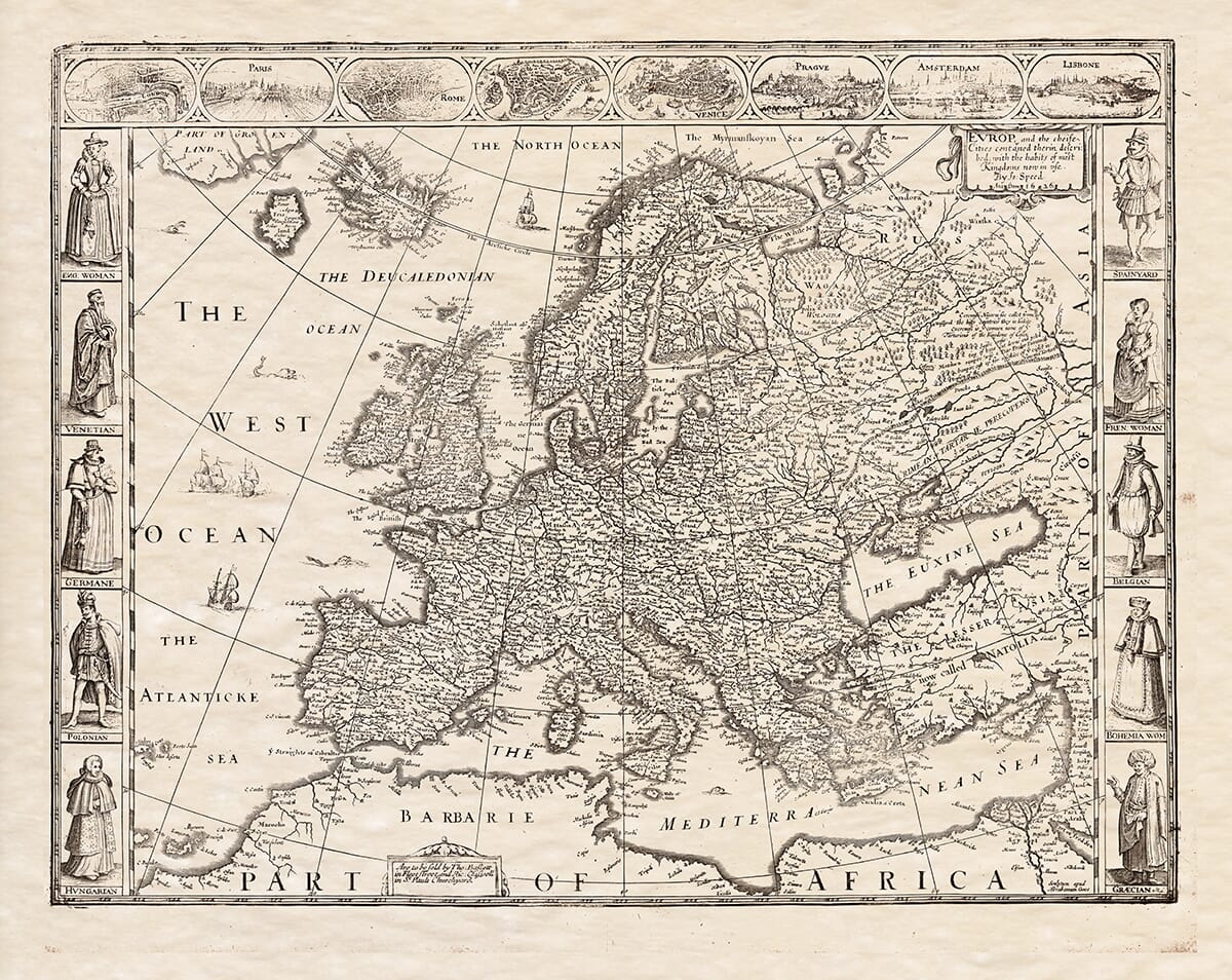
John Speed added historical notes on the rear of his maps (the verso) here’s his
The Description of EUROPE.
EUROPE may perhaps think herself much injured to be thus cast back into the third place of my division, and reckoned last of the Old World: but my promise shall be here made good, to give her her due. And although Chronology will not allow the precedency, yet compare her present state with the rest, and you may take her rank here to be ad pompam, as most commonly in our solemn Triumphs those of most worth are marshalled forth last. Yet were she so minded to quarrel for Antiquity, she could not want store: such as would have some parts of Europe flourish within thirty years after the confusion of tongues. The original of the German Kingdom is drawn by Aventinus, Helmesus, and others, from Tuisco, the son of Noah, and he began his reign in the year 179 after the Flood, and that was but 131 years after the Deluge, not above thirty from the time that they were dispersed out of Babel. But to pass by those uncertainties which may admit dispute, we have to this day the German Trier, a city standing from the time of Abraham, and bears the marks both of the antiquity and of the Babylonians. As if here they strove to reach eternity, as they did before in the plain of Shinar to heaven.
(2) Sure I am, whatever part of the World was first famous, Europe soon got the start, and took the Sceptre of the entire government: and well she might, if we but read her story, since first the man we call the Great Monarch Alexander was her champion. In the Latin Empire the Roman enlarged the sway, and since left a corner of the earth then known ungoverned. And to this the Princes of Europe always bent their dominions upon the regions of the other. A small portion as we are at this little isle, in respect of their vast continent, yet we have a part too in America for our peculiar, and hope still to bring more into our possession, that we may bring them unto Christ.
(3) In respect of the two other quarters in the Eastern Hemisphere, Europe is partly West, and partly North: For she is situated northward, betwixt the Tropic of Cancer, and the polar Arctic: and westward hath no continent betwixt her and America, but is bounded with the Atlantic Ocean. On the East toward Asia, she hath the Mare Aegeum, which the Latins call Archipelago, and the Bosphorus, called the Straits of Meyer, and the Palus Maeotis, and the River Tanais. Southward it hath the Mediterranean and African Seas, towards the West a peninsula, whose isthmus yet joins it to the rest of the Continent, is to be reckoned that part which lieth betwixt the branches of the River Tanais and the Mare Glaciale. These are her out-bounds.
(4) Yet live we here within, we shall find that nature had not spent her store, nor was the clod-handled when she allotted her portion. And though Europe indeed be the least of the three divided in all points of the compass, yet is it the far most odious as those of Asia and Africa, and her mountains no less famous than Tanais or Atlas. Her ground indeed is not comparable to any other of the other: She bears in longitude but 3,800 miles from Vstivet in Tartary to Compostela in Spain. And in latitude at most 1,800, from the Isles in the frozen Sea, by some account not above 900.
(5) But her extent (as I said) fills; it adds to her glory, that in regions are temperate sweet: that she exceeds the other quarters, and bears the name of the most Happy Country in the World, both for plenty of Corn, Plants, Fruits, Rivers and Fountains of admirable virtues, for beauty as well of Cities, Castles, and Houses, as men and women of excellent feature. For the study of Arts, for efficiency in Religion, and whatever else God hath pleased to bless his Church with from the beginning.
(6) She wants nothing but what she may well spare; wild beasts which cause deserts in other parts where they breed; spices, which fit not our tempers and rather corrupt our manners than mend our diet; precious jewels and the like, which have been of more danger than good, and were better known before by our predecessors; yet not of gold, silver, and other commodious metals, she hath her portion. And though it is of no prosperous temper, yet of so infinite variety, that it is admirable to think that there is no place in this quarter, but is fit for any man to live in. Though as every one is inhabited, as is confirmed by our later travellers: though heretofore it hath been surmised, how some parts of her were cold toward the Pole, this is in general.
(7) In her division, we will begin from her Western parts, that lie towards the first Meridian of Longitude, and go on till we come to her Eastern limits, which joins her to Asia. The orders: (1) Spain. (2) France. (3) Belgium. (4) Germany. (5) Italy. (6) Denmark. (7) Hungary. (8) Poland. (9) Great Britain. (10) Greece. (11) Dacia. (12) Norway. (13) Sweden. (14) Muscovy.
(8) Every great region of Europe merits a peculiar description at large, and shall in its turn partake of my pains, such as it is. In the meantime I will here instruct my reader in the general knowledge of each, and direct him principally to their situation, that he may with ease find their propinquity and distance in respect of each other, which cannot be so aptly expressed in their several maps: nor so easily learned as in this, which presents to his eye all at one view.
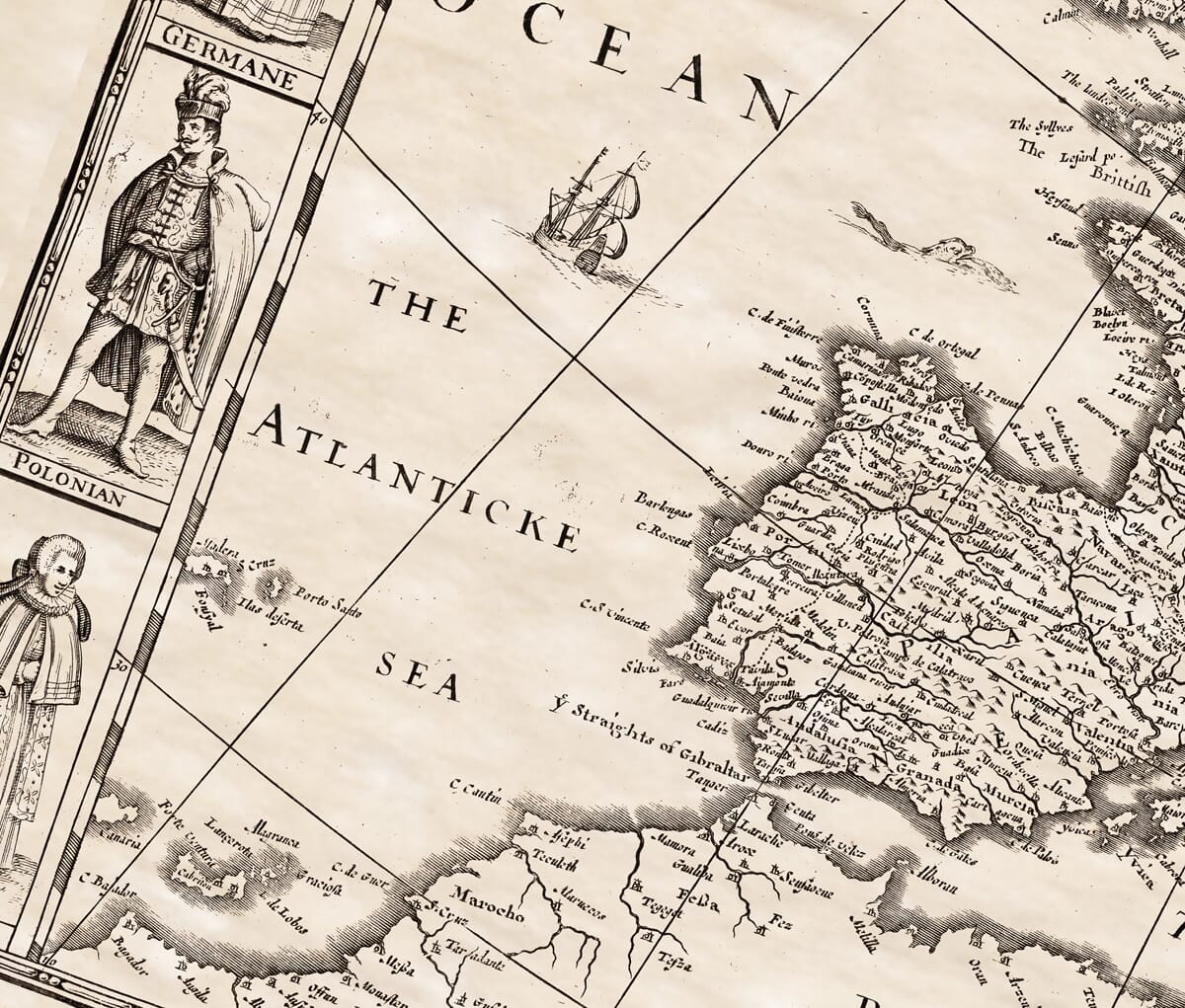
(9) Spain is the first and the amplest region of Europe; for in breadth it numbereth 12,000 stadia, Latin Appianus, and for length 18,000 (as it seemeth) in length. The compass is reckoned by some to be 1,800 English miles. It is beset on every side with seas, unless on the Eastern, and there it is joined to Europe by a kind of Isthmus, where the Pyrenean Mountains cross from one Sea to the other, and set the limits to both Kingdoms. On the West it is bounded with Atlantic Ocean, on the North with the Cantabric, and on the South with the Inner Mediterranean: South-east with the Mediterranean. Till within this 500 years it continued mangled and broken by many tyrants in fortune. Since it hath lived quietly, now it is wholly subject to one Monarch, though yet every man free of three Kingdoms, Aragon, Castile, and Portugal. The Land yields all sorts of wines, sugar, fruits, grain, oils, metals, especially gold and silver. It is fertile enough for the inhabitants, yet indeed they are not many, nor have they so great cities as there are in other regions in Europe. Besides, the conditions of those which most part are bad. The meanest, proud; the richest, superstitious and hypocrites: most of them lascivious. Give them their own, they are good soldiers, not too much for their valour in performing, as patience to endure labours, hunger, thirst, and by this means oft-times weary out an enemy rather than conquer him.
(10) France the second region of Europe, beginneth from the West at the Pyrenean Mountains, and is bounded on the East with Germany, on the North with our English Seas, and southward with the Mediterranean, south-east with the Alps, which divide it from Italy. It was once the mansion of most of these parts besides, and had its division into Provinces and Dukedoms. Now the chief are Lorraine, Burgundy, Savoy, and these have their free Princes; the rest are Normandy, Brittany, Berry, Aquitaine, France, Poitou, Languedoc, Anjou, Gascony, Provence, Cominge, and many more. The Country is very fruitful, and calls all her neighbour nations thither for traffic. Their special commodities are Wine, Honey, Salt. Well-peopled, and hath very many illustrious Cities. But the inhabitants are naturally light in their carriage, and counted the wantons of the World; yet for Arms, Valour, and Learning not was. Commended by all strangers for complete Courtship.
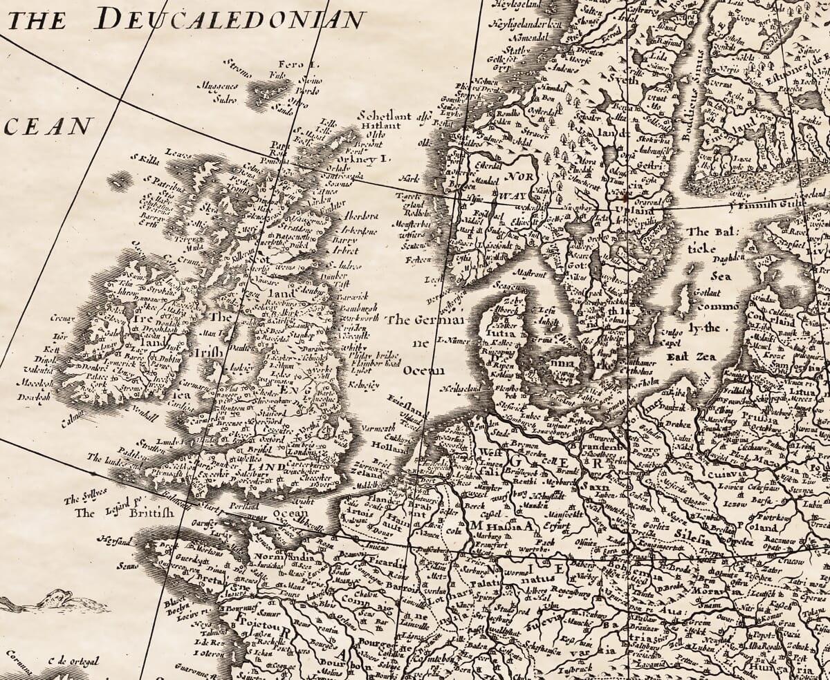
(11) Belgium hath France on the South, on the North Germany, on the East Germany, and the main Ocean on the West. It is best known with us by the Low-Countries, or Netherlands. The compass of it is about a thousand miles. It is divided into 17 Provinces. And of these, four are Dukedoms (seven Earldoms, five Baronies, and one Marquisate.) The Dukedoms are (1) Brabant, and in this Antwerp. (2) Luxemburg. (3) Limburg, here the far north of Ardenne. (4) Gelderland. The Earldoms, (1) Flanders. (2) Artois. (3) Hainault. (4) Holland. (5) Zeeland. (6) Zutphen. (7) Namur. The Baronies, (1) Friesland. (2) Utrecht. (3) Mechlen. (4) Overijssel. (5) Groningen. The Marquisate is that of Antwerp. The Land is of a wonderful great strength for butter, cheese, and breeds oxen of incredible bigness and weight. The people too are very industrious, and excellent mechanics. The men commonly are of a goodly portraiture: yet of more fame for their wars than their valour: but are forced to maintain their liberty by the sword. The seamen indeed, and in that they bear the low sway. Their Governors are called the States of the Low-Countries. The chief of their forces is the Prince of Orange.
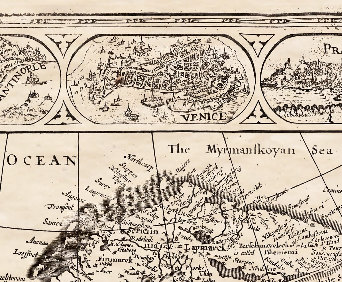
(12) Germany lieth eastward from Belgium, and on her own East is bounded with Hungary and Poland, and the River Vistula: on the North with the German Ocean, and on the South with the Alps that divide her from Italy. In the middle it is seated almost the centre of Belgium, compacted of the Slav Nations, and in this stands Prague, where the Emperor of the West keeps his Court: and comprehends many Provinces and Counties, as Savoy, Brandenburg, Pomerania, Bavaria, Silesia, Franconia, Austria, Helvetia, East-Friesland, Westphalia, Cleveland, Alsatia, Brunswick.
the description on the rear (verso) of John Speed’s Old Map of Europe continued on the right hand side of the Old Map of Europe . . .
Brunswick, and Lusatia. It hath now the name of the Empire, as once Rome had, but it comes far short of her glory. The right of Election ends not by succession, but by choice in six Electors, Arch-Bishops of Trier, Mentz and Cullen, Count Palatine of Rhine, Duke of Saxony, and Margraves of Brandenburg. In case of equality, the King of Bohemia hath a suffrage and carries it. It is rich Country. In Corn, Wines, Fruits, Mines, and hath in all healthful Baths. The people valiant, and ingenious for the invention of many useful implements.
(13) Italy hath on the North, divided by the Alps, on the South the Mediterranean, on the East the Adriatic Sea, and on the West Mare Tyrrhenum. In length it is 1200 miles, and in the broadest place 420. It was once entirely one, now it is divided into many States and Provinces. The chief are the Kingdom of Naples, the Territory of Rome, Lombardy, Tuscany. The Signory of Venice, Verona, and others of great fame. For indeed the whole Country is of admirable fertility, and called by good Authors, the Paradise of the Earth. The Inhabitants grave and frugal; yet hot and lascivious.
(14) Denmark is upon Germany on the South, and on the West hath the river Germanicus, and on the North the Sarmatic Sea, and is a Peninsula. In the Continent are two Provinces of note, Jutland and Holstein. The other are petty Islands for the most part. The chief Zealand and Cimbria. The Country breedeth goodly bodies, fit for food or Cattel. The people are good Soldiers, and subject to one King.
(15) Hungary hath part of Germany on the West, on the East the River Tibiscus, and Valachia, on the North with Poland, and on the South with the River Savus, South-west with Sclavonia. The great Danubius cuts her in the middle, and names her parts Cisdanub and Ultriver. The chief Provinces are (1) The Country of Silesia; where the earth sends forth such a fat clammy, that it poisons the very birds which die over it. (2) A land in Denmark exceeding fertile; and in all indeed is the whole Country. The people are generally honest, but shew their Ancestry to be of the Scythian by their barbarous manners, and neglect of learning. Their daughters are only a new attire; and their sons equally inherit without privilege of birthright. The Emperor of Germany and the Turk share it betwixt them.
(16) Poland and Silesia, a Province of Germany on the West, on the East the River Borysthenes or Nieper; on the North the Baltic Sea, and Hungary on the South. It is in compass 2600 miles. The chief Provinces which belong at least to Poland are, Livonia, Lithuania, Volinia, Samogitia, Podolia, Russia nigra, Mazovia, Prussia, Podlachia, the Dukedoms of Oppulia and Zator, Polonia propria. The Land abounds with Honey, Wax, Mines of Copper and Iron. It breeds store of fish fit for merchandize. Their Religion is promiscuous of all kinds from the true worship, they do every Atheist, which acknowledged one supreme power, are governed by one King, which doth not succeed, but is chosen by the Nobles.
(17) Sclavonia hath Hungary on the North, on the South the Adriatic Sea, Greece on the South-east and on the West part of Italy. It is in length 480 miles, in breadth 120. The people were called Sclavi, and were by Conquest of the Venetians made their drudges. It is now divided into Illyricum, Dalmatia, Croatia. From the tongue of this Nation is used through many Countries both of Europe and of Asia: part of it belongs to the Government of Hungary, some to the Turk, some to the Austrians, and some to the Venetian State.
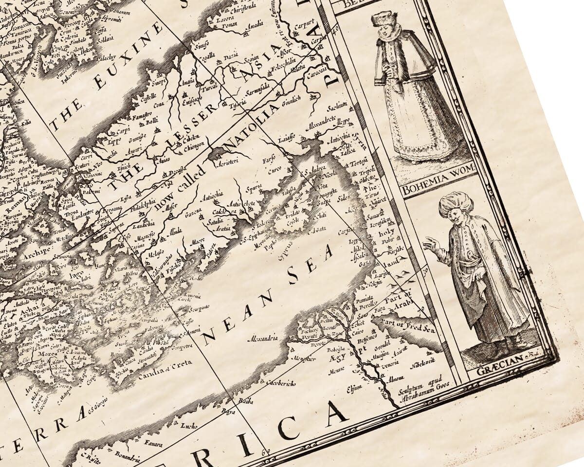
(18) Greece is limited on the West with the Adriatic Sea; on the East with the Aegean, Hellespont, Propontis, and Northwest with the Mountain Hæmus, and Southward with the Mediterranean. It was once the seat of the Worlds Empire, and flourished far beyond all others in every kind of humane learning, which to this day is received by all Christians as the best rule. It was of the first among the Gentiles that received Christ, and sent out many Fathers of our Church, Schyr, Sophan, Basil, Gregory, and others. But the inhabitants are corrupted and keep low, as well in knowledge as estate, by the tyranny of the Turk. Their women are well-favoured and beautiful. The common division is into three Regions, Peloponnesus, Achaia, Epirus, Albania, Macedonia, Thessalia. The land is very fruitful, and yields Corn, Silks, Copper, Colours, Wines, Sweet Stuffs, etc.
(19) Dacia on the West hath Hungary, on the East the Euxine Sea, on the South Greece, on the North Sarmatia, which it is divided by the Carpathian Mountains. It was heretofore Mœsia, and was by Domitian parted into Mœsia Inferior and Superior. Now the chief Regions are Transilvania, Walachia, Moldavia, Servia, Rascia, Bulgaria, Bosnia.
(20) Norway or Norwegia derives her title from the very name, which signifieth in the German tongue the north way; and properly so it is in respect of the rest of Europe, and almost desolated almost with rocks and ice. The length is 1,300 miles, the breadth about 600. The people were once valiant for prey and Conquests in most places of Europe. Amongst the rest England hath her share, and was forced to submit to Duke William, and Ireland too amazed. But since times are uncivil for a foreign government of the King of Denmark, and live finely enough in possible riches worth the contending, except honesty. That it is counted the greater fame among them, yet they have Cables, Nails, Furrs good for use, and Stock-fish, which they rather in stead of bread. The Metropolitan City is Nidros: besides there is not above two of eminent note. Bergen one of the chief Towns of Christendom, and Alsa a Port of much fame.
The North and West stands the populous Province of Finnmark. (21) Sweden or Suetia on the East of Norway divided from it by a branch of the Sarmatic Sea, on the North and South it is bounded with the same: the East and the South by Muscovia. By reason of their neighbourhood, they partake much in their dispositions with the Norwegians. Their Country is fertile, & in some Provinces hath very great plenty of Corn, Pastures, Mines of Gold and Silver, Copper, Lead, and other excellent commodities, from which they take their name. For the first is Gothland, as much as good land. The second Finland, a soft fine Land. The rest are Bodia, Scricfinnia, Lapland, &c. The Inhabitants live to a great age, of 140, and are much given to witchcraft.
(22) Muscovia is the last Region of Europe we are to describe, and indeed stands a good part in Asia. It is bounded on the West with Livonia, & on the North separated from the East with Tartary, from the North with the frozen Seas, southward with the Caspian. The length of it is 5200 miles, the breadth 3065. It is watered with many huge Rivers as Volga, Raft, and the like. The air is extreme cold: but Nature for the help of the inhabitants hath lined it with Furrs, Sables, Martins, white Fox, and the like: and hath furnished it with other commodities, Corn, Fruits, and Cattel. The whole Region is subject to the Emperor of Russia. A vast Territory, and a vast government. For the people are hardy, contumacious, and wonderfully populous. Their burly chest and upright stature fits them for hardships, penny in his purse, and apt to St. Nicola for procuring entrance into Heaven. There are many Provinces of note. The chief are, (1) Muscovia, where Mosco stands (the principal seat of the Emperor). (2) Permia, where they eat their ashes clean instead of bread. (3) Rhaesia, so full of Corn that horses cannot tread it down, for a great part goes through it. But I am not very urgent to force belief upon my Readers. Other there are which have their stories of as much wonder, and as little credit. But I must not pass them by this way, I leave it to the pains of some posterity. I have already set footing in Asia: give me leave to recover my self into my proper bounds, and I will in a brief description end the Islands, which are reckoned as the appendices to Europe.
(23) They are first in the Atlantic Ocean Greenland, Island, Friesland. The ice hindereth the Arctic, and are extreme cold, but send forth good store of fish. The next rank is in the British Seas: Ireland, Great Britain, with the Isles of the Hebrides, Hebrida, Silly Islands, Man, Angle-sey, Wight, Jersey, Garnsey. Of these, Ireland is 1450 miles, and doth adde a good way to our own, and after the Queen of Spain hers. The Land for sea is of each called out from the rest, which for the proportionable distance from the South, is very like to her neighbour France, a temper, that neither our former heat can compell us to handle, nor our winter cold surmise us to the fire, so, Maginus.
And under our lines are fall in pleasant places we have many. The chief of those which fall of Irish regard in the German Seas, and others which divide Norway and Sweden are Denmark in Poland. More toward Spain we arrive at the Azores, nine in number. Of the rest, St. Michael is visited with greatest note, for noble Sir Walter Raleigh’s discovery of the Spaniard 1597.
(24) The Southern Islands of Europe lie about the Mediterranean. The first ranker, (1) Balearae next unto Spain: in which are (2) Sardinia, one and again Italy, where it parts from France. (3) Sicily, famous for the gulf Charybdis, which answers to the Scylla on the Italian side, and for the shipwracks which oft-times they made up the fable of those Sea-monsters mentioned in our ancient Poets. (5) Malta the seat of the illustrious Knights. The second Classis of Islands is in the Adriatic, and Ionian Seas. Pliny and Solinus find situated on the North-east of Italy, Absyrtides, Cyrniæ, Scardona, Issa, Dalmatia, Ulfa, Tyrannyn, Pharia, Coryra, Melina, more South toward the Mediterranean Corcyra, Erictis, Cephalenia, Ithaca the Country of Ulisses, Echinades Islands, Zacynthus, Messenia, Andros, and just as it were in the mouth of the Aegean, we may call Candia, an Isle of 520 miles circuit, and signed by the name of Crete, the birth place of Jupiter, famous with old Poets. And a luscious Wine which we call Malmsey.
(25) The last and the Islands behind in the Aegean Sea, which indeed are not easy to number. The chief are Samos, Delos, Chios, Patmos, Cos, the Cyclades, Sporades, Paros, Tenos, Lemnos, Samothracia, and Mytilene, whereof from Mytilene cometh the fine Mitylene cloth. And now we are not many miles distant from Asia. From hence we take room to travel farther, if you desire to have an exact review of the particular, you must provide me almost a seaven years voyage. Let it suffice for the present, that when your eye hath once past hence into the other ancient Authors, your passage is here discovered to your hand.