There are maps that tell you how to reach a place, and there are maps that allow you to enter another age.
The Agas Map of London belongs firmly to the second kind.
At first glance, it is a great spread of streets, churches, houses, fields and river traffic. Look a little longer, however, and the London it depicts begins to come alive. The Thames is busy with small boats. London Bridge is crowded with buildings. Church towers rise above tightly packed rooftops. Beyond the city walls are gardens, pasture, windmills and open ground.
It is recognisably London, but not the London we know.
This is the capital before the Great Fire of 1666, before the rebuilding of St Paul’s Cathedral and long before the railways, broad roads and immense suburbs that would eventually surround the old City. The map catches London at a particularly fascinating moment: still medieval in much of its appearance, yet already growing into an international centre of commerce, government and culture.
NOW AVAILABLE AS A FINE ART PRINT
For anyone interested in London history, it is difficult not to become absorbed by it.
What is the Agas Map of London?
The map is formally titled Civitas Londinum, although it is generally known as either the Agas Map or the Woodcut Map of London.
It is one of the earliest surviving printed maps to show London in substantial detail. Rather than presenting the city as a flat street plan, it uses a raised, bird’s-eye viewpoint. Streets, buildings and open spaces are shown at an angle, giving the impression that the viewer is looking down upon London from somewhere high above the south side of the Thames.
The result is part map and part panorama.
It is not perfectly consistent in scale or perspective, nor was it intended to meet modern cartographic standards. Important buildings are often enlarged so they can be recognised. Streets widen or narrow according to the demands of the composition. Some structures are shown more symbolically than literally.
Yet this is part of the map’s charm. It does not simply plot London. It portrays it.
The original design is generally thought to date from sometime between 1561 and 1570. The image was cut onto eight wooden printing blocks and printed in separate sheets, which were then joined together to create one large panoramic view.
Only three early impressions are known to survive. These are held by The London Archives, The National Archives and the Pepys Library at Magdalene College, Cambridge.
That small number of surviving examples makes the map a remarkable historical object in its own right.
Was it really made by Ralph Agas?
For generations, the map was credited to Ralph Agas, an Elizabethan surveyor and mapmaker. His surname became so closely associated with it that “the Agas Map” remains the name by which most people recognise it.
More recent research has made that attribution look increasingly unlikely.
Agas was certainly active as a surveyor and produced important maps elsewhere. However, there is no firm evidence that he created this particular view of London. The dating of the map, together with what is known about Agas’s early career, makes his authorship doubtful.
The name nevertheless survives, as historic names often do. Calling it the Agas Map is now less a claim of definite authorship than a familiar and convenient title.
Its true designer, surveyor and woodblock cutter remain unknown.
In some ways, that mystery only adds to the map’s appeal. A work of enormous complexity was created, printed and circulated, yet the people responsible for it have largely disappeared from the record.
An earlier map lies behind it
The Agas Map did not emerge entirely from nowhere.
It appears to have been based on an earlier and more finely engraved map of London, now known as the Copperplate Map. That ambitious work was probably surveyed during the 1550s and printed from an estimated fifteen copper plates.
Only three of those original plates have survived.
The surviving fragments reveal an astonishing degree of detail. Individual buildings, gardens and streets were engraved with considerable care. The full map must have been one of the great cartographic undertakings of Tudor England.
The Woodcut or Agas Map seems to have adapted this earlier design into a form that could be printed from wooden blocks. Woodcut printing was less capable of very fine detail than copper engraving, but it made it possible to reproduce the image more economically.
The Agas Map is therefore both a great work in its own right and an echo of an even earlier map that has almost entirely vanished.
Later maps of London also appear to draw upon the same family of images. The familiar view published by Georg Braun and Frans Hogenberg in 1572, for example, presents London in a related bird’s-eye form, though on a smaller scale.
Together, these maps provide a visual record of the capital at the beginning of the Elizabethan age.
London gathered around the Thames
The first thing most viewers notice is the River Thames.
It stretches broadly across the lower part of the map, dividing the City of London from Southwark. To modern eyes, accustomed to thinking of London as an enormous area spreading in every direction, it is striking to see how closely the life of the city is gathered around the river.
The Thames was London’s main highway.
Boats carried passengers across and along it. Barges transported food, timber, fuel and merchandise. Royal and civic processions travelled by water. The river connected London with the rest of England and with trading ports across Europe.
On the map, it is far from empty. Small vessels move in different directions, while larger craft lie closer to the banks. The water gives space and movement to what might otherwise have been an overwhelmingly dense image.
The river also helps us understand why London developed as it did. Wharves, warehouses, markets and commercial buildings crowded the northern bank. On the southern side, Southwark grew around the bridgehead and the roads leading towards Kent and Surrey.
London was shaped by the Thames long before it was shaped by railways or underground lines.
The old London Bridge
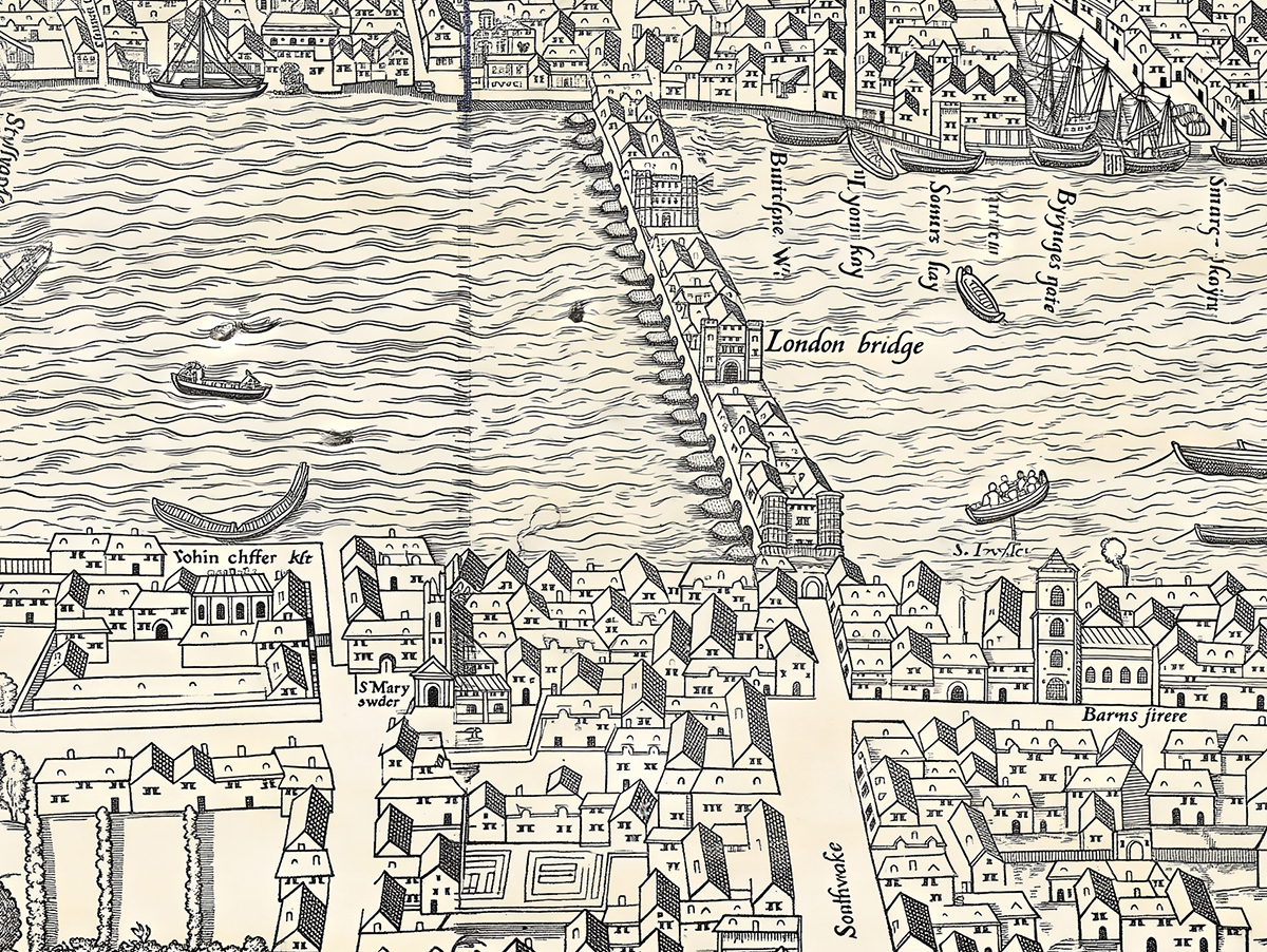
The map’s representation of London Bridge is one of its most memorable features.
This was not the comparatively open bridge known today. The medieval bridge was lined with houses and shops, forming what was effectively a narrow street across the Thames. Its many stone arches restricted the flow of the water, creating dangerous currents beneath.
At its southern end stood a gate through which travellers entered Southwark. The bridge was both a practical crossing and a powerful symbol of London itself.
For centuries it was the only permanent bridge across the Thames within the capital. Anyone approaching from the south would have encountered its crowded buildings and gateway before passing into the City.
On the Agas Map, the bridge seems almost like a district in its own right. Buildings rise from it, while boats pass through the arches below.
It is one of those details that immediately separates Tudor London from the modern city. We recognise the river and the general position of the bridge, yet the structure itself belongs to a vanished world.
St Paul’s before Wren
Another great landmark is Old St Paul’s Cathedral.
The present cathedral, designed by Sir Christopher Wren, was built after the Great Fire. The Agas Map shows its medieval predecessor: an immense Gothic church that dominated the City skyline.
Old St Paul’s was one of the largest churches in Europe. Its long nave, high roof and great central tower made it visible from far beyond the city walls.
The cathedral had once possessed an exceptionally tall spire, but this was struck by lightning and destroyed by fire in 1561. The absence of the spire from versions of the Woodcut Map is one of the clues used when considering the date of the image.
Even without it, St Paul’s remains a commanding presence.
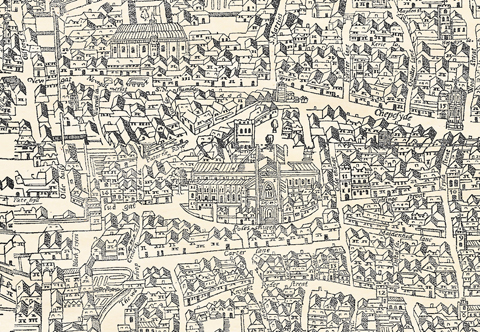
The map reminds us that historic buildings were not isolated monuments. They stood at the centre of active neighbourhoods and were woven into the daily life of the city.
The walls, gates and suburbs
Much of London still lay within the line of the old Roman and medieval walls.
The wall can be followed around the northern and eastern edge of the City, punctuated by gates such as Aldgate, Bishopsgate, Moorgate, Cripplegate, Aldersgate, Newgate and Ludgate.
By the sixteenth century, these defences had lost much of their military purpose. London was expanding beyond them, and suburbs had developed along the main roads leading out of the gates.
Even so, the walls continued to define the City. They marked a legal, social and administrative boundary, separating the old civic centre from the districts growing around it.
The contrast is especially clear on the map.
Inside the walls, streets and buildings are densely packed. Outside, the city thins quickly into scattered houses, gardens and fields. The transition from urban London to countryside appears remarkably abrupt.
To the north, Finsbury Fields are shown with windmills and open spaces. Archery was practised there, an activity encouraged because trained bowmen remained important to national defence. Elsewhere, narrow roads pass through land that would later be covered by some of the busiest parts of central London.
Places now thought of as wholly urban still sat at the edge of the countryside.
Southwark and the world beyond the City
Across the Thames, Southwark has a different character.
It was outside the direct jurisdiction of the City authorities for much of its history and became associated with inns, theatres, entertainments and activities that were more closely regulated north of the river.
The Agas Map shows buildings stretching south from London Bridge along the main road. Nearby are the areas later famous for playhouses, bear-baiting arenas and riverside entertainment.
The surviving version of the map includes the bull-baiting and bear-baiting grounds. These are uncomfortable reminders of the harsher amusements of Tudor and early Stuart London, but they were prominent parts of popular culture at the time.
Southwark also became closely connected with the history of the London stage. Shakespeare would later live and work in the capital, and his world can be explored through many of the places represented on the map.
Although the exact dates do not align perfectly with every episode of his career, the image gives us one of the clearest visual impressions of the London Shakespeare encountered.
A city of churches
One of the most noticeable features of the map is the sheer number of church towers.
Before the Great Fire destroyed or damaged so many of them, the City contained a remarkable concentration of parish churches. Each served its own small neighbourhood, and their towers helped define the skyline.
They were religious centres, of course, but also points of local identity. Parish life shaped charitable giving, burial, public announcements and many practical aspects of community organisation.
The density of churches also helps explain why the City looks so vertical in early views. Among the low timber and plaster houses, towers and steeples stood out sharply.
After 1666, many were rebuilt by Wren and his colleagues. Others disappeared entirely as parishes were combined or streets redeveloped.
The Agas Map preserves the pattern of the pre-fire city before that transformation took place.
What the map can and cannot tell us
It is tempting to treat such an old map as a photograph, but that would be misleading.
The Agas Map is an interpretation of London, shaped by the methods, conventions and practical limits of its time.
Buildings are not always shown at their true scale. The angle of view changes. Streets may be simplified. Important landmarks are given prominence, while humbler structures can become repeated rows of roofs and gables.
Nor should every figure, boat or tree necessarily be read as something witnessed at one particular moment. Such details help suggest the character and activity of the city.
Yet the map remains enormously valuable.
It records the broad arrangement of streets, walls, gates, major buildings and open land. It shows the relationship between the City, Westminster, Southwark and the surrounding countryside. It allows historians to compare written records with physical locations.
Perhaps most importantly, it helps us imagine the scale of Tudor London.
The city was crowded and busy, but it could still be crossed on foot. Fields lay close to its gates. The river dominated movement. The skyline belonged to churches rather than office towers.
The map makes those facts visible in a way that words alone cannot.
Why it remains so compelling
Part of the lasting fascination of the Agas Map comes from the tension between familiarity and difference.
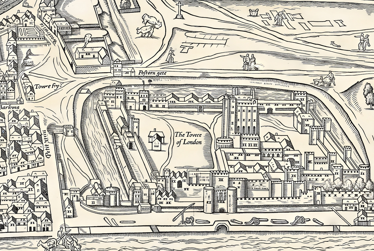
Names such as Cheapside, Fleet Street, Bishopsgate, Aldgate and the Strand still belong to London. The Thames follows its familiar course. The Tower stands in its recognisable position.
Yet almost everything around them has changed.
Modern roads have widened. Railways have cut through old districts. Bombing and redevelopment have removed entire streets. The Great Fire transformed the centre, while centuries of rebuilding altered the rest.
Looking at the map becomes an exercise in recognition. We search for places we know, then try to understand what stood there before.
This is one reason the map is not merely of academic interest. Londoners often approach it personally. They look for a workplace, a neighbourhood, a familiar church or the site of a present-day street. Visitors use it to make sense of the historic City beneath the modern one.
It can be studied for years and still produce surprises.
From historic document to statement piece
The Agas Map also has an extraordinary decorative quality.
Its wide panoramic proportions suit a large wall particularly well. From a distance, it forms a complex architectural pattern. Closer inspection reveals streets, gardens, gates, boats, churches and hundreds of smaller details.
It works in both contemporary and traditional interiors because it does not behave like conventional decoration. It brings depth, age and a genuine connection to place.
The map has been particularly popular through our sister site, The Old London Map Company. Copies have been purchased for London homes and apartments and have also been specified by interior designers looking for a strong, historically grounded statement piece.
Perhaps the most rewarding response has come from London tour guides. Some have praised the map as something they use regularly, not simply as wall art but as a practical way of explaining how the early city was arranged.
That seems entirely appropriate.
More than four centuries after it was created, the map is still helping people find their way around London — not necessarily through its present streets, but through its history.
Reproducing the Agas Map today
Historic maps of this scale present particular difficulties when they are reproduced.
Original scans can contain fading, uneven colouring, joins between sheets, marks, stains and areas where the detail has become difficult to read. Removing too much can make an old map appear artificial. Leaving everything untouched can result in a print that looks dull or confused.
The Old Map Company has digitally edited a scan from the original source with the aim of restoring clarity and balance while retaining the map’s historic character.
The intention has not been to redesign it or make it appear newly created. Instead, the work has involved bringing forward detail, improving tonal consistency and preparing the image so that it can once again be appreciated at a substantial size.
A successful reproduction should still look old. It should retain the texture, line and atmosphere of the original, but it should also have enough definition to reward close inspection.
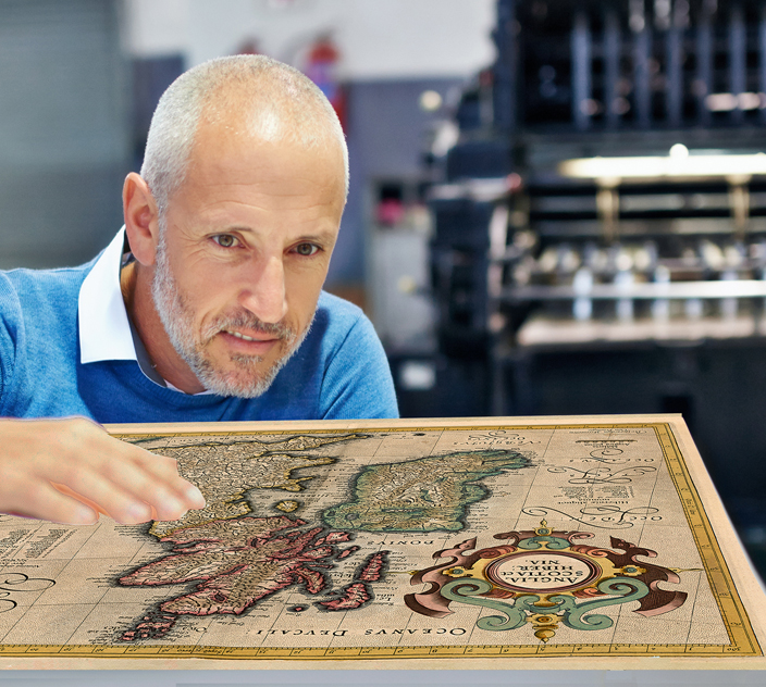 The hope is to create a fine art print comparable in spirit to how the map may have appeared when its blocks were first inked and the sheets brought together.
London before it became modern
The Agas Map is often described as a map of Tudor London, but it is more than a record of streets and buildings.
It shows London on the edge of enormous change.
The city was expanding beyond its walls. Overseas trade was growing. The Royal Exchange would become a symbol of London’s commercial ambition. The theatres of the Elizabethan age were emerging. The population was increasing rapidly.
At the same time, much of the city still retained its medieval form.
The walls and gates remained visible. Timber-framed houses lined narrow streets. Religious buildings inherited from earlier centuries dominated the skyline. Open fields began almost immediately beyond the suburbs.
Within a little more than a century, plague, fire, rebuilding and continued expansion would transform much of what the map records.
That knowledge gives the image its particular poignancy. We are looking at a city that no longer exists, but from which modern London developed.
A map that still invites exploration
The best historic maps do not surrender everything at once.
They ask to be revisited.
One day, the eye may be drawn to London Bridge or St Paul’s. On another, it might follow the line of the city walls, examine the gardens outside the gates or trace the crowded riverfront. Someone familiar with London may recognise a surviving street. Someone new to its history may simply enjoy the spectacle of the whole city spread across the page.
That is the enduring strength of the Agas Map.
It is an important historical document, an intricate work of art and one of the most absorbing images ever made of London. It records a capital that is distant from us in time but unexpectedly close in geography.