
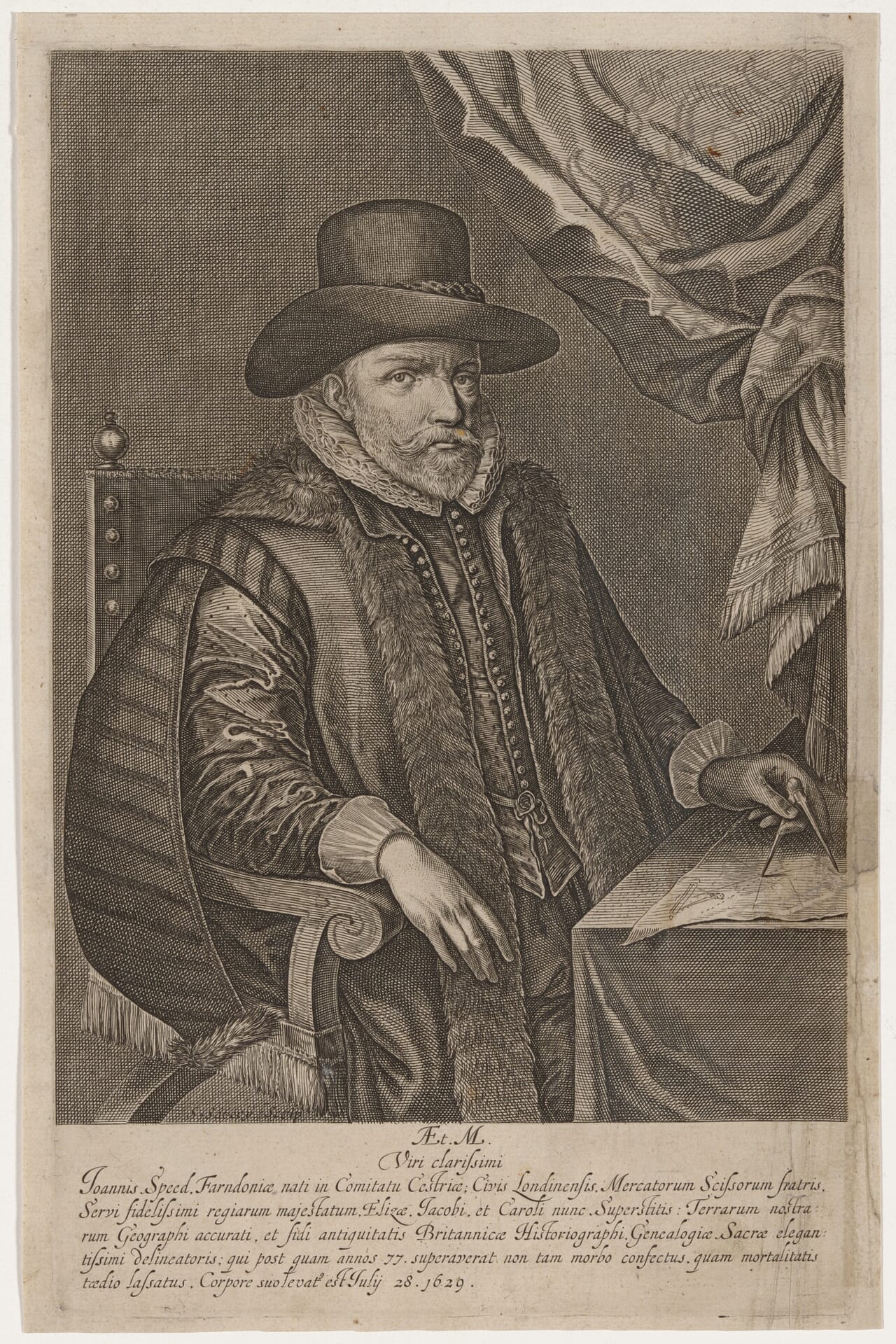
Engraved and published by Salomon Savery in 1632. A translation of the Latin inscription appears towards the end of this article.
Look closely at a John Speed map and the county becomes only part of the story. A town opens out in miniature; heraldic shields recall influential families; a monument, royal portrait or small human figure draws the eye towards the margins. These details reward a slower look. They also explain why Speed’s maps remain so engaging more than four centuries after their first publication.
John Speed (1551/2–1629) brought geography, history and the identity of individual places together on the printed page. Understanding how he assembled his work makes it easier to appreciate both its achievement and its limitations.
From a tailor’s workshop to the study of Britain
Born at Farndon in Cheshire, Speed began his working life as a tailor. His interests in antiquities, genealogy and maps eventually brought him into a scholarly circle supported by Sir Fulke Greville. That patronage gave him the opportunity to devote himself to research, with access to people and collections far beyond his original trade.
Speed’s atlas belonged to a larger historical undertaking. The Theatre of the Empire of Great Britaine, published in 1611–12, accompanied his Historie of Great Britaine. One presented places; the other followed Britain’s past through successive rulers. His maps make more sense when read as the work of a historian who wanted readers to connect a landscape with its remembered events.
What did Speed actually survey?
Speed did not independently measure every county. Much of the underlying geography came from earlier mapmakers, including Christopher Saxton and John Norden. He acknowledged his borrowing. His achievement lay in selecting, adapting and supplementing that information, then giving it a remarkably recognisable presentation.
The town plans were a particularly important contribution. Cambridge University Library describes the Theatre as containing 73 plans, with at least 50 representing the earliest mapping of the towns concerned. These small insets can therefore preserve evidence that is much harder to recover from the county outlines alone.
Look for a scale of paces on a town plan. In his address to readers, Speed associated that feature with his own travels and measurements, taking a pace as five feet. Other plans drew upon existing work. The distinction matters: a Speed atlas combines original observation with compilation, rather than applying one method uniformly throughout.
Small scenes that bring the maps to life
Cambridge’s digitised proofs reveal details easily missed at first glance: a ploughman with a two-horse team outside Worcester, visitors at Stonehenge in Wiltshire, and bathers at Bath. On the Cambridgeshire sheet, figures in academic dress accompany the university and college heraldry. These are useful starting points for exploring a map beyond the search for a familiar town.
A rewarding way to read a county sheet is to make three passes. First follow the rivers and settlements. Then examine the town inset, comparing its streets and crossings with places you know. Finally explore the margins. The combination can reveal how a county was described, how its principal town was arranged and which people or institutions were chosen to represent it.
The Cheshire map that never reached the finished atlas
One of the most intriguing survivals is an early Cheshire proof engraved by William Rogers. Cambridge holds one of only two known examples. The published atlas used a completely different plate.
The abandoned design includes a portrait of Elizabeth I. Cambridge’s discussion offers several possible explanations for its replacement: the portrait may have seemed dated after her death, a closer match with the later engraving style may have been wanted, or the plate may have been lost or damaged. None is established as the answer. The uncertainty is part of the interest: surviving proofs show decisions being made, but do not always tell us why.
An atlas made between England and Amsterdam
Jodocus Hondius’s Amsterdam workshop engraved the copperplates for the main project. The lettering and imagery had to be cut in reverse so that the printed impression would read correctly. Proof sheets could then travel back to England for checking.
Cambridge’s Gardner collection contains 66 proof maps, many of which differ from their published versions. These sheets have no text on the reverse. They offer a rare view of the atlas before it became the familiar finished book.
Why the date on a map needs care
A date engraved on a Speed map does not, by itself, establish when a particular impression was printed. Plates continued in use through later editions and changes of publisher. Cambridge notes that the typesetting on the reverse of published sheets can help narrow their publication date.
Rochester Cathedral’s atlas provides a useful example: it is a 1676 edition, issued decades after Speed’s death, and includes additions and revisions. Its maps are monochrome. Other surviving copies were hand-coloured, so colour should not be treated as a single fixed scheme shared by every historical copy.
For anyone comparing an original with a reproduction, the useful question is therefore which edition or surviving sheet supplied the image. The early date associated with a map’s design and the date of the particular printed example may be different.
A portrait of Stuart ambition
The atlas also reflects the monarchy under which it appeared. James VI of Scotland inherited the English and Irish crowns in 1603. Speed’s Scotland map includes James, Queen Anne and their sons Henry and Charles; royal arms and the dedication reinforce that dynastic setting. The kingdoms shared a monarch, but were still distinct. Reading the portraits alongside the geography helps explain the atlas’s presentation of Britain.
The man remembered
The portrait at the top of this article was published in 1632, after Speed’s death. The National Portrait Gallery identifies the engraver as Solomon Savery, also known as Salomon Savery. The inscription remembers a historian and a maker of sacred genealogies as well as a geographer—a broader description than his modern reputation as a county mapmaker might suggest.
In memory of a most distinguished man
John Speed, born at Farndon in the County of Cheshire; a citizen of London; a member of the Merchant Taylors’ Company; the most faithful servant of the royal majesties Elizabeth, James, and Charles (now reigning); a precise geographer of our lands; a trustworthy historian of British antiquities; and a most elegant draftsman of sacred genealogy.
After he had lived for 77 years, he was overcome not so much by illness as by weariness of mortality itself.
He departed this life on July 28, 1629.
I am both privileged and humbled to have introduced his work to many millions of people across the world both through our supply of reproductions of his work through heritage sites and the medium of the internet.
Stephen Plomer-Roberts
The Old Map Company
Explore John Speed’s maps
Find a place connected with your own family or local history. Our John Speed prints are modern fine art reproductions of historic maps.
Sources and further reading
- Cambridge University Library: John Speed proof maps
- University of Cambridge: Mapping the origins of a masterpiece
- Cambridge University Library: A Theatre of Treasures
- Cambridge University Library: Speed maps now in the Cambridge Digital Library
- Royal Museums Greenwich: Mapping the Theatre of the Stuarts
- Rochester Cathedral: John Speed’s atlas, 1676
- National Portrait Gallery: John Speed, by Solomon Savery