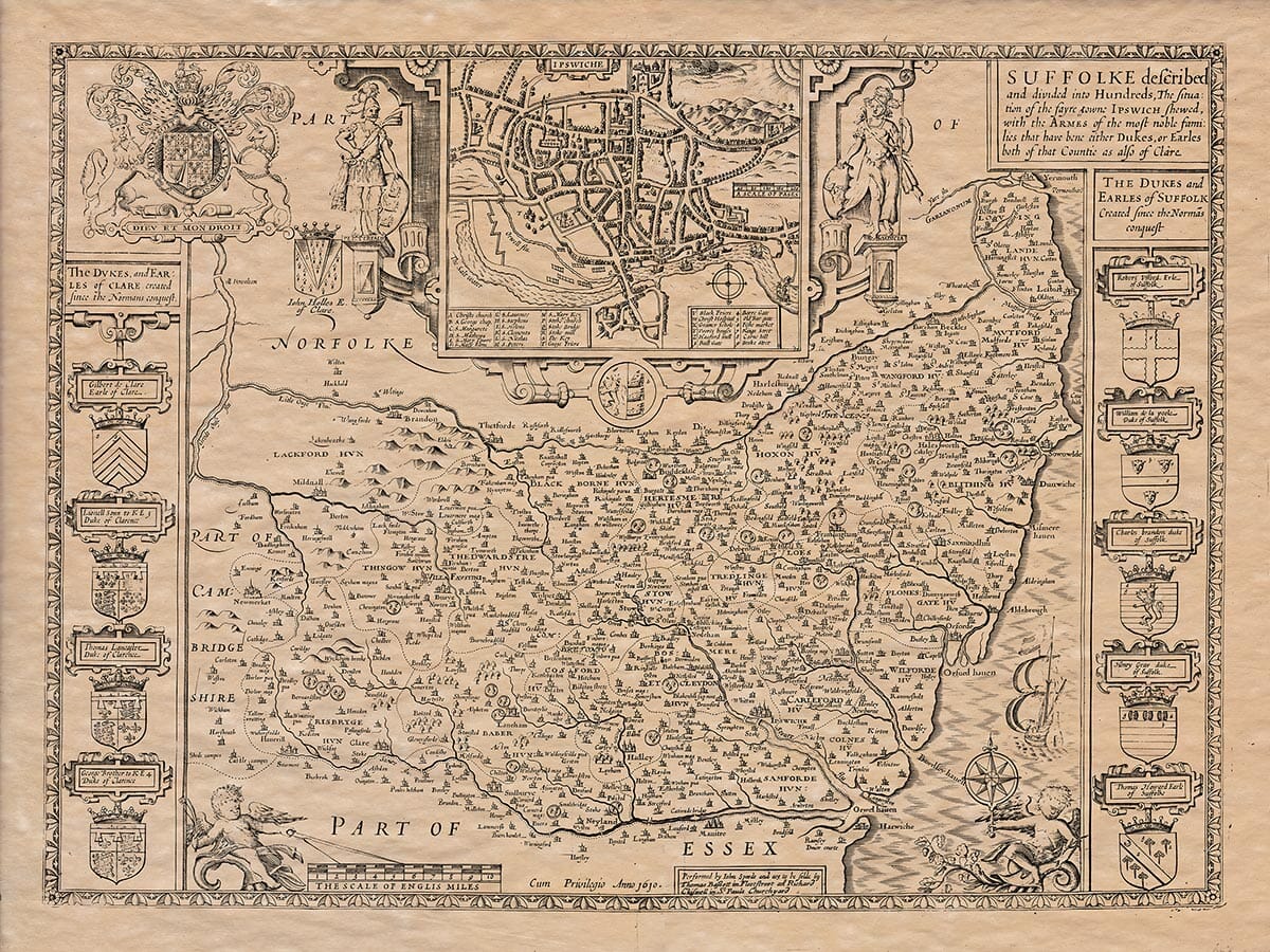
John Speed added a short essay which was published on the rear (the verso) of his Old Map of Suffolk which we have translated into modern English . . .
The Description of Suffolk
Suffolk, known as “Sub-Folc” by the Saxons, was named in relation to those who lived in Norfolk. It is a county that is rich in resources and an excellent place for people to live. Suffolk is separated from Norfolk by the smaller rivers Ouse and Waveney, which nearly meet in the middle of the county. The Ouse flows east and the Waveney flows west. On the western side, Suffolk borders Cambridge. To the south, the River Stour separates Suffolk from Essex, and on the east, it is washed by the German Sea.
The air in Suffolk is pleasant, fresh, and delightful. It is considered by some of the best physicians to have some of the healthiest air in the country. The soil is fertile and productive, offering everything one might desire for both enjoyment and profit.
The shape of the county is somewhat crescent-like, with the north side narrowing and the south side spreading out. The widest part of the county is about 20 miles across, but from east to west it is much larger. From the easternmost point of the county (which is the furthest point of Suffolk and all of Britain into the sea) to the great River Ouse on the west, the distance is 45 miles. The total circumference of the county is about 136 miles.
In ancient times, Suffolk was inhabited by the Iceni tribe, who, according to Tacitus, had friendly relations with the Romans. The Iceni were a mighty people, but they were defeated by the Romans under Ostorius in the reign of Emperor Claudius, though not without heavy Roman losses. In a battle, Marcus Corius, the son of the Roman general, earned great honor for saving a Roman citizen’s life. The Iceni’s grievances were not easily overcome, and after being mistreated by the Roman soldiers—who took their land and treated their leaders as slaves—the Iceni, under the leadership of Boudica, took revenge, as will be further explained in the history.
After the Iceni, the Saxons moved into this area, and Suffolk, along with Norfolk, Cambridgeshire, and the Isle of Ely, became part of the East Angles Kingdom. However, it seems they were often under the rule of the Mercians or the Kings of Kent. This continued until King Edward the Elder brought the region under control, making it part of his West Saxon kingdom. Later, after the Norman Conquest, many noble Normans gained estates in Suffolk, and their descendants still live in the county today.
Suffolk has many valuable resources, including grain, livestock, cloth, pasture, woods, sea fish, and fowl. The county is described by Abbo Florencensis as being lush and beautiful, filled with orchards, gardens, and groves. Over 600 years ago, he described it as such, and it is still true today. One of Suffolk’s key exports is cheese, which is traded widely, not just in England, but also in Germany, France, and Spain. The quality of Suffolk cheese is highly praised by the physician Pantaleon for both its color and taste.
If Ipswich, the main town of the county, had been as fortunate with its name as it was with its commerce and buildings, it could have rightfully been called a city. It is not a small town, and its trade, size, and importance rival many other towns across the land. It seems that Ipswich was once surrounded by a rampart made of earth, particularly along its northern and western sides, with gates for entrances. However, these were likely destroyed by the Danes in 991 AD when they raided and plundered the coastline. In 1000 AD, they again destroyed the town, leaving its streets and buildings in ruins. However, Ipswich later recovered its prosperity, and today, from Stoke Church in the south to St. Margaret’s in the north, the town covers 1,900 paces. From St. Helen’s in the east to St. Matthew’s in the west, the town stretches 2,120 paces, with many streets densely populated. The town has 12 parish churches, aside from the suppressed ones, such as Christ Church, St. George’s, St. James’s, and the Friars. Ipswich is governed annually by two bailiffs, ten portmen, and 24 common councilors, all wearing scarlet, along with various other officials in blue. The town is located at latitude 52.25 degrees north and longitude 22.9 degrees west.
The other important town in Suffolk is Bury St. Edmunds. According to Abbo, this was the royal town where King Sigebert of the East Angles established a Christian church at the dawn of the Saxon conversion. The town is named after St. Edmund, who was buried there after being killed by the Danes at Hoxne. A magnificent monastery was built in honor of St. Edmund, especially under King Canute, who was moved by a vision of the martyr’s ghost. The town’s abbey was once one of the most impressive in the world, with its high revenues and glorious architecture. The ruins of this abbey remain, though they are now in a sad state, evoking pity from those who view them.
Suffolk has other places of note, including Exning in the west, which is famous for being the birthplace of St. Audrey, daughter of King Anna. Kenilworth in the east was once home to King Redwald, the first Christian ruler in England. Hadley in the south is notable as the burial site of Guthrum, the Danish leader who was baptized by King Alfred. One particularly strange place is the “Devil’s Ditch,” a boundary marker of the East Angles’ territory, and there are curious legends about this area, such as the story of two green boys emerging from the ground in Wulpet. A more peculiar event occurred near Orford, where a man-like fish was captured and kept in the castle for six months before escaping back into the sea. In 1555, a crop of peas grew without being planted or tilled between Orford and Aldeburgh, in an area that had no soil, just hard rocks.
There were many religious sites in Suffolk that were devoted to God, including St. Edmund’s, Ipswich, Ickleworth, Blithborough, Clare, Leiston, and Dunwich. Many of these were monasteries that were suppressed during the reign of King Henry VIII, with their revenues taken by the crown.
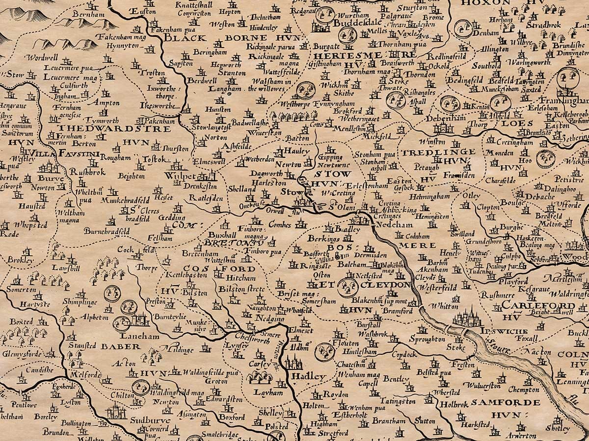
Suffolk is divided into three main regions: the Celdable, St. Edmund’s, and St. Audrey’s Liberties. These are further divided into 22 Hundreds and 575 parishes. The county is home to seven castles and 32 market towns.