Description
John Speed added a short essay which was published on the rear (the verso) of the old map Northampton which we have translated into modern English . . .
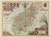
Northamptonshire, located near the center of England, was known to the Saxons as Nopparen-Sonrcine. It is bordered to the north by Lincolnshire, separated by the River Welland, and to the east it is divided from Huntingdonshire by the River Nene. To the south, it is bordered by Buckinghamshire and Oxfordshire, and to the west it is separated from Warwickshire by Watling Street and the Rivers Avon and Welland, which divide it from Leicestershire.
The shape of the county is large and narrow, widest in the southwest, and gradually narrowing in a shape somewhat like a horn, not unlike Cornwall. The distance from the point where the Cherwell River enters the county to the point where the Welland and Nene rivers meet near Cromland is about 36 miles. The widest part of the county is from Ouse to Avon, which is just under 20 miles across. The total circumference of the county is around 119 miles.
The air in Northamptonshire is temperate and healthy, the land is open, rich, and fertile. The area is so densely populated that from some hills, you can see 30 parish churches and many windmills in one view. Surprisingly, the sheep, once gentle and harmless creatures, have become so greedy that they now begin to devour men, ruin fields, and depopulate houses, even whole villages, as some humorously claim.
The ancient inhabitants of this county, known to the Romans and mentioned by Ptolemy, were the Coritani. They lived here and spread into Leicestershire, Lincolnshire, Nottinghamshire, Rutland, and Derbyshire. After being conquered by the Romans under Publius Ostorius Scapula, they were eventually subjugated and became part of the Roman province. Later, the Saxons, a warlike people, took over this land, making it part of their Mercian kingdom. When the Saxon rule faded, the Normans took control of the land, and their influence spread throughout the area, which remained fruitful and beautiful.
The main resources of the county come from farming, with grain growing in abundance—more so than in any other part of the country. The pastures and woodlands are filled with cattle, and sheep are everywhere, heavily laden with wool.
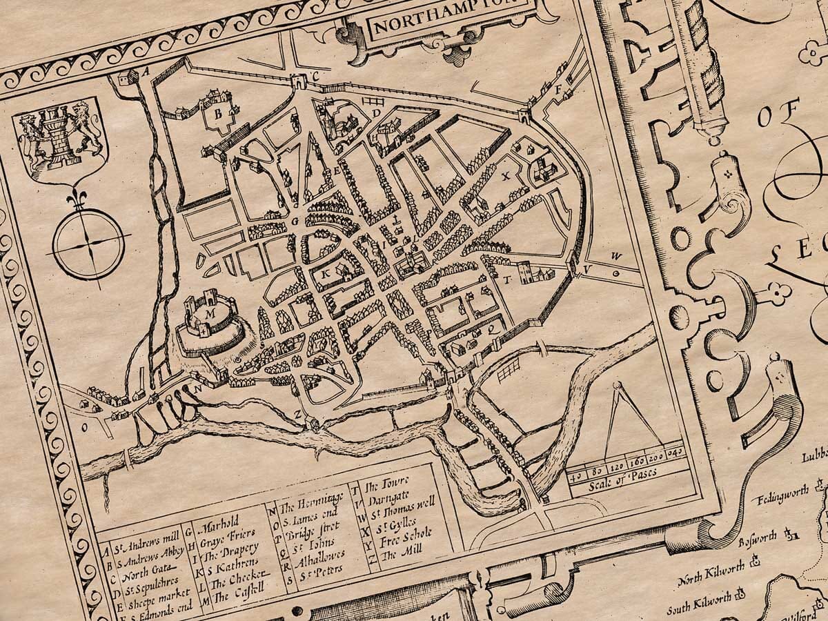
The main town in Northamptonshire is Northampton, which takes its name from the county. It is a large and beautiful town, comparable in size and grandeur to some of the greatest cities in the land. It is located at the confluence of two rivers, the larger of which is called the Nene. The town was built entirely of stone, and remnants of its foundations can still be seen today. It is strongly walled, except to the west, where the river divides into multiple streams, offering natural protection. In times of war, the town was set on fire by King Sweyn of Denmark and later attacked by rebellious barons during the reign of King John. However, the town remained loyal to King Henry III, despite the turbulent civil wars.
There is a castle on the western side of the town, perched on a hill. The castle’s old and weathered appearance still suggests its former grandeur. The town’s walls stretch in a circular pattern, meeting the river to the north, and the entire circumference measures about 2,120 paces. The site was so admired that students from Cambridge University considered moving there to establish a new university, though that never happened. The town lies 52 degrees, 36 minutes north of the equator, and its longitude is 19 degrees, 40 minutes west. The town is governed by a Mayor, two Bailiffs, twelve Magistrates, a Recorder, a Town Clerk, a Common Council of 48 members, and five Sergeants.
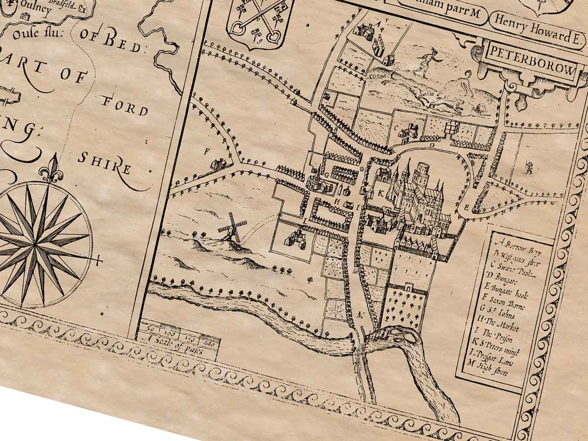
The Saxon Kings helped make Peterborough famous, which was once known as Medeswel. It was here that Wolphere, the King of Mercia, founded a grand monastery dedicated to St. Peter in atonement for the murder of his two sons. This monastery was later destroyed by the Danes but was rebuilt more magnificently by Bishop Ethelwold of Winchester and King Edgar. The cathedral there is stunning, and in the choir, two unfortunate queens are buried: Catherine of Spain, the divorced wife of King Henry VIII, and Mary, Queen of Scots. The cloisters are large, and stained glass windows beautifully depict the story of Wolphere, the founder of the monastery.
Other religious houses in the county were located in places like Peakirk, Higham, Daventry, Sulby, Sewardesleg, Gare, Luffield, Catesby, and many others, but all of these faced destruction during the reign of King Henry VIII, who dissolved the monasteries and confiscated their wealth. Even the tombs of his predecessors, such as Edward IV and Richard III, were desecrated.
The Earldom of Northampton has been held by eight princely families, with the most recent holder being Henry Howard, the former Lord Privy Seal, who was a patron of learning and a supporter of these efforts.
For administrative purposes, the county is divided into twenty Hundreds, and there are ten cattle markets and twelve market towns, along with 336 parish churches.