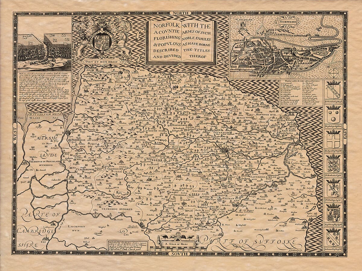
John Speed added a short essay which was published on the rear (the verso) of his old map of Norfolk which we have translated into modern English . . .
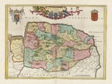
Norfolk is an island that is roughly oval in shape, bordered on the south by the Waveney River and the Lesser Ouse, which separate it from Suffolk. To the east and north, it is bordered by the North Sea; to the west, it is separated from Cambridgeshire by branches of the larger Ouse River; and towards Lincolnshire, it is bounded by part of the Nene River, which flows from Wisbech into the marshes.
The county spans about fifty miles in length (from Yarmouth to Wisbech) and about thirty miles in width (from Thetford to Wells). The total perimeter is approximately 242 miles.
The name “Norfolk” comes from its people, who, being the northernmost of the East Angles, are called North-folk, just as the southernmost are called South-folk.
The climate is sharp and biting, especially in the open fields and near the sea. As a result, it delays both spring and harvest due to the county’s position at about the 53rd degree of latitude.
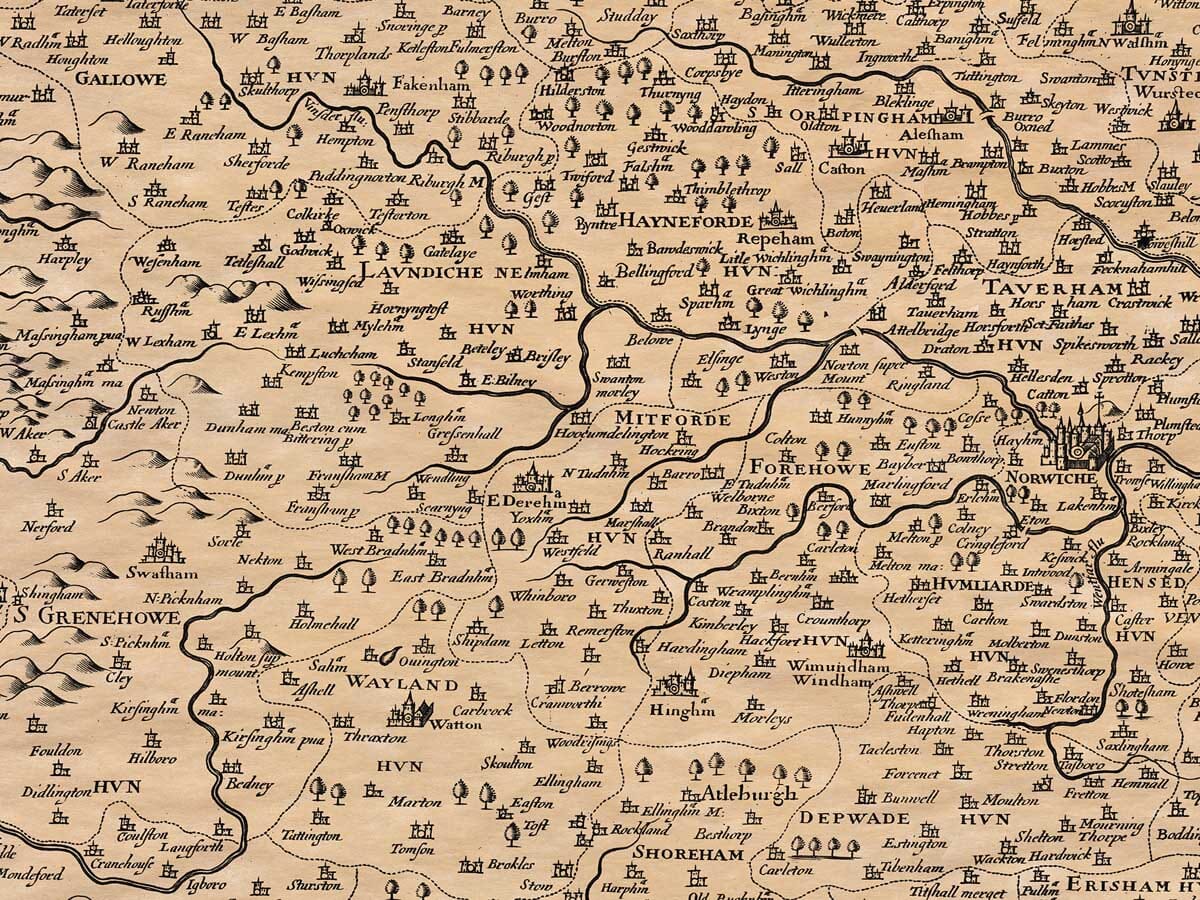
The soil varies: near the towns it is generally fertile, with clay, chalk, or suitable earth, well-watered and with some woodlands. However, moving towards the heathlands, it becomes dry and barren. The marshlands and Flegg (a region in Norfolk) are exceptionally rich: marshlands are ideal for pasture, while Flegg is more suited for growing corn.
From Thetford to Burnham, and along the coastline, the land is known as “champion” land, which is open and fertile. The rest of the county, being richer in woods, is considered woodland. The champion land is abundant with corn, sheep, and rabbits. The barren heathlands are highly profitable, as they are used for sheep grazing, which is called “fold-course” in Saxon times, or “Falbrocun” meaning liberty of fold or grazing. The compactness of the sheep enriches the land so much that when they are plowed, they match the most fertile soils of other regions. These heathlands provide abundant and excellent grazing for sheep, making them one of the county’s main sources of wealth. The woodland areas, which are better for grass, are mainly used for cattle grazing but are also well-stocked with corn and sheep.
The coastline is rich in fish and has many good harbors, with Lynn and Yarmouth being the most important. Wells and Blakeney are also well-regarded harbors.
The county is filled with rivers and springs, the most significant being the Ouse River. Its many branches feed into the Isle of Ely, Cambridge, Huntington, and Suffolk, facilitating trade and transportation. The Yare River, flowing from Norwich to Yarmouth, is another key river, especially useful for water transport and famous for its abundance of fish.
The people of Norfolk were once known as the Iceni, a tribe also found in Suffolk, Cambridgeshire, and Huntingdonshire. They were thought to be among the people Caesar referred to as the Cenimagni, and Ptolemy called the Simeni, or sometimes the Tigeni. Their customs were likely similar to other Britons at the time—barbarous, as noted by Caesar and Tacitus. However, since the Normans’ arrival, Norfolk’s people have become known for their civility and intellectual pursuits. They have built more churches and monasteries than any other county in England, and many of the greatest families and nobility in the kingdom trace their origins to Norfolk.
In Roman times, Norfolk was governed by two military garrisons, one at Yarmouth and the other at Branodunum (now known as Brancaster). After the Saxons arrived, Norfolk became part of the kingdom of the Angles, and in the year 561, it was established as a kingdom by Uffa. The kingdom suffered greatly in 870 when it was overrun by the Danes, who destroyed it and killed the virtuous King Edmund. However, King Edward later reclaimed it.
During the Norman period, Norfolk became part of the Earl of East Anglia’s lands. After the conquest, King William the Conqueror gave much of Norfolk to his followers, dividing the land into many smaller holdings. Norfolk and Suffolk were initially united as one kingdom, then as one earldom, and continued together in one sheriffdom until the 15th year of Queen Elizabeth’s reign.
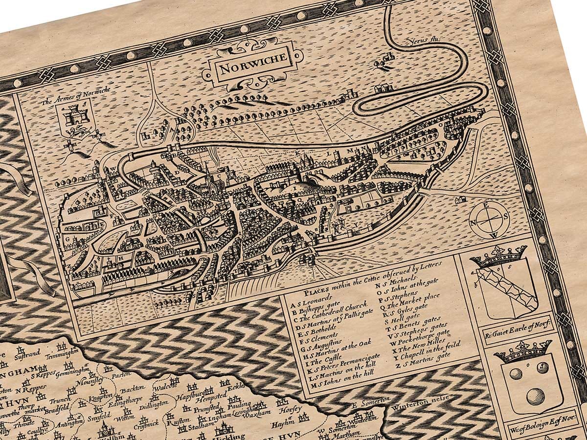
The towns in Norfolk are generally well-built and populated, with three towns in particular—Norwich, Lynn, and Yarmouth—being of such significance that no other English county has their equivalent. Norwich, once the capital of East Anglia, is known for its old history and its rise from the ruins of neighboring Venta (now called Caistor). Although it was devastated by the Danes in 1004, it later became a significant merchant hub by the time of King Edward the Confessor.
Lynn was once a borough governed by a reeve but was granted special privileges by King John in the 6th year of his reign, and later expanded by King Henry III. Yarmouth, located at the mouth of the Yare River, is the key to the region’s coast and has always been important for fishing and trade. It has a single church, but it remains well-fortified and is an important trading hub.
The bishopric of Norwich was initially located at Dunwich in Suffolk, established by the missionary Felix, who converted the East Angles to Christianity. After some changes, the bishopric was eventually moved to Norwich, where it has remained ever since.
Norfolk is also famous for its natural resources, including rivers, fish, wool, corn, and honey. In short, Norfolk is a county blessed with many advantages, both natural and cultural, making it one of the most prosperous regions in England.
This description of Norfolk was given to me by the Right Honorable Sir Henry Spelman, Knight.