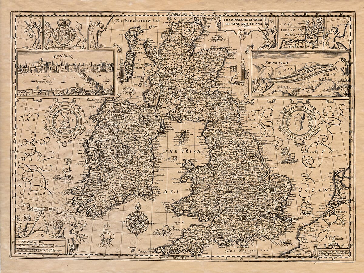
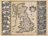
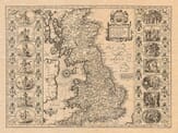
THE GENERAL DESCRIPTION OF GREAT-BRITAIN. Book 1.
Albionis verò: frondoso cincta superbit,
Arboribus, frugibus, atque pecore.
Gramineam Montem & fundant pascua pennis;
Et pecus, et cervini crescunt praedam domus.
Sed Latini caruit patribus tellus dominii,
Viridi potior floruit in Latio.
Albion’s high top serene, lofty her frame,
With woods of bearing Birds, and Fry of Woods was famous,
The Plain and Meadow’s kind, and herds abounding,
Meadow and Down with Flocks and herds abounding.
Latium had greater wealth, but Cæsar brought
Britain Glory, Latium’s Wealth was nought.
The division of Britain concerning the Government and Territories thereof, at such time as Cæsar here arrived, doth not sufficiently appear. Cæsar himself makes so sparing mention therein, that we have little cause to believe Florence, when he makes Llyday say, that after Cæsar had slain an huge multitude of Britains, he fals’d the residue of the Isles. But rather with evident suffrage, that he did not at all subdue the whole, nor the sword’s intended end in him purport.
Kings there were, and therefore that division which was there in Cæsar’s time, was into Regiones, the old names of whole Nations, as also the knowledge of their several heads, hidden under the rubbish of so many ages, have of late with infinite labours, and exquisite judgment, been probably restored and bounded; yet that no man’s expectation and desire be too much frustrated, reason will thus be briefly set forth, the divisions of the Land, as many repute not only genuine, but authentic.
Our seeming ancient Historians being but a few, who to every of their three sons gave a part, called presently after their names, as Locrine to Locrine his eldest Son; Camber to Camber his second Son; and Albanic to Albanic his third Son: And doubtless, if there had been more Nations of name in this Island, Brute should have had more Sons fathered on him: which conceit some ascribe to Monmouth, holding that before him it was never so divided.
Plowman naming Britain the Great, and the Less, hath been by some mistaken, as dividing this Island into two parts; but his proportion and distance from the Æquator, compared with his Geographical description will evince, that he called this our Island Great-Britain, and Ireland Britain the Less.
Howbeit some later do make indeed the South and more Champion to be called Great-Britain, and the North more mountainous, Britain the Less; whose Inhabitants anciently were distinguished into the Matie, and Caledonii, and now by the Scots are made one People, named Lovalbanius. But that Northern Tract being long piercing into the Roman Constitutions, and less profitable or fruitful, they left their bounds not far from Edenburgh, and altogether neglected the other parts more Northward.
This newer part of Britain they then divided into two parts; for the more Southern tract, together with Wales, Dio termeth the Higher, and that more Northward the Lower, as by the seats of their Legions doth appear: for the second Legion Augusta (which kept at Caerleon in South-Wales) and the twentieth called Victrix (which remained at the City Chester) in the Higher Britain: but the sixth Legion surnamed also Victrix, resident at York, served (as we writeth) in the Lower Britain, which afterwards, as we read, was made a Province.
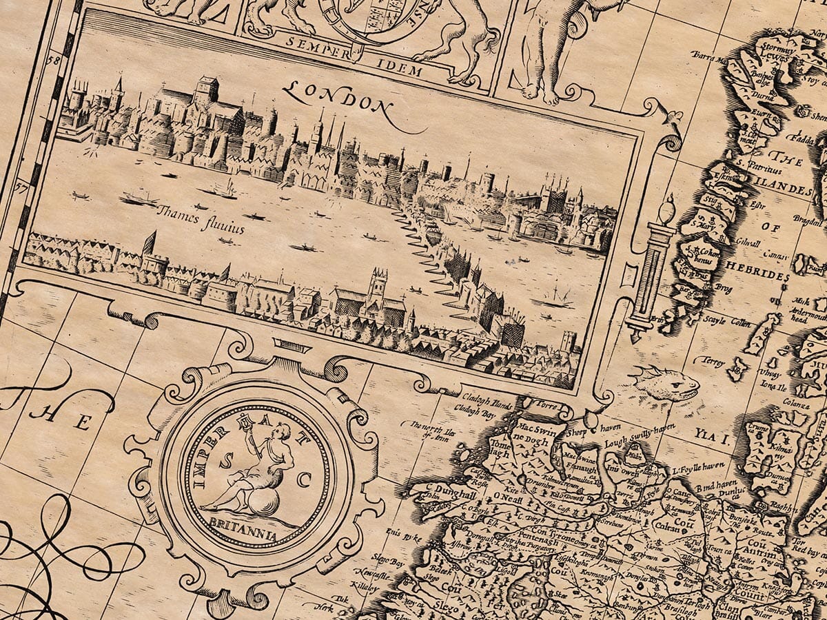
After this again the Romans did apportion Britain into four parts, who limits our great Antiquary assigneth by the ancient Archiepiscopal Seats, grounding his conjecture on the saying of Pope Lucius, who affirms that the Ecclesiastical Jurisdictions of the Christians accorded with the precincts of the Roman Magistrates; and that their Arch-Bishops had their Sees in those Cities wherein their Presidents abode: for the ancient Seats of the three Arch-Bishops here, being London in the East, Caerleon in the West, and York in the North; London’s Diocese (as seemeth) made Brit. Prima, Caerleon, Brit. Secunda; and York Maxima Cæsariensis.
But in the next age, when the power of their Presidents began to grow greater, they again divided Britain into five parts, adding to these three former, Valentia and Flavia, whereof the first of which two seemeth to have been the remoter part of Maxima Cæsariensis, recovered from the Picts and Scots by Theodosius the General, under Valence the Emperor, and in honour of him, named Valentia: and Flavia may be conjectured to receive the name from Flavius the Emperor (Son of Theodosius) for many of the name Brit. Flavia, before his time.
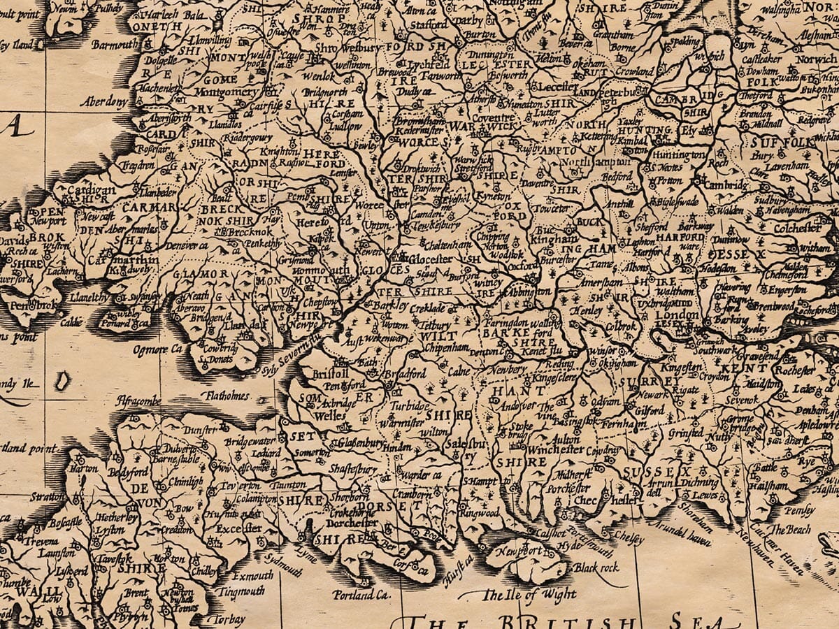
So these five partitions had their limits assigned after this manner, Brit. Prima contained those coasts that lay betwixt Thamesis, the Severn, and the British Sea: Britain Secunda extended from Severn unto the Irish Seas, containing the Country that we now call Wales: Flavia Cæsariensis, was that which lay betwixt the Rivers Humber and Tyne: and Valentia from the said River, and Picts-wall reached unto the Rampier once replenished in Scotland, the farther part that the Romans possessed, when this division was in use. For the several people inhabiting all those parts, with their ancient Names and Borders (whether designed by the Romans or old Britains) together with our modern Names and shires, are here to each matched: we will refer you to the Tables thereof, elsewhere.
This whole Province of Britain, as our History shall appear, was highly esteemed of the Emperors themselves, assuming as a glorious Surname BRITANNICUS: coming thither in person over the dangerous & scarce known Seas, here marrying, living and dying; enacting here Laws for the whole Empire, and giving to those Captains that served here, many Ensigues of great honour: yea, Claudius gave Flavius (the first Prefect of that Province) the right hand, as he accompanied him in his Triumph: and his own Triumph of Britain was set out with such magnificence, that the Province brought in golden Crowns of great weight, the Governors commanded to attend, and the very Captains permitted to be present at the same: A Naval Coronet was fixed upon a pinnacle of his Palace, Arches and Trophies were raised in Rome, and himself on his aged knees mounted the stairs into the Capitol, supported by his two Sons in Law: so great a joy conceived he in himself for the Conquest of some small portion of Britain.
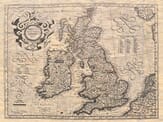
How the Romans found it, held it, and left it, as times ripened and rottened their flourish: the Names, the Inhabitants, Manners, and Resisters, I leave to be pursued in the following Histories: and will only now shew the three chief Bodies of Great-Britain Monarchy; two of which (Scotland and Ireland) shall in their due places have their farther and more particular descriptions.
The atlas was printed in black and white. Many editions were then hand coloured . . . there’s a short article on the colouring of old maps here >