


Above: The verso of the map.
Below: A translation of verso of the old map of Cambridgeshire onto modern English.
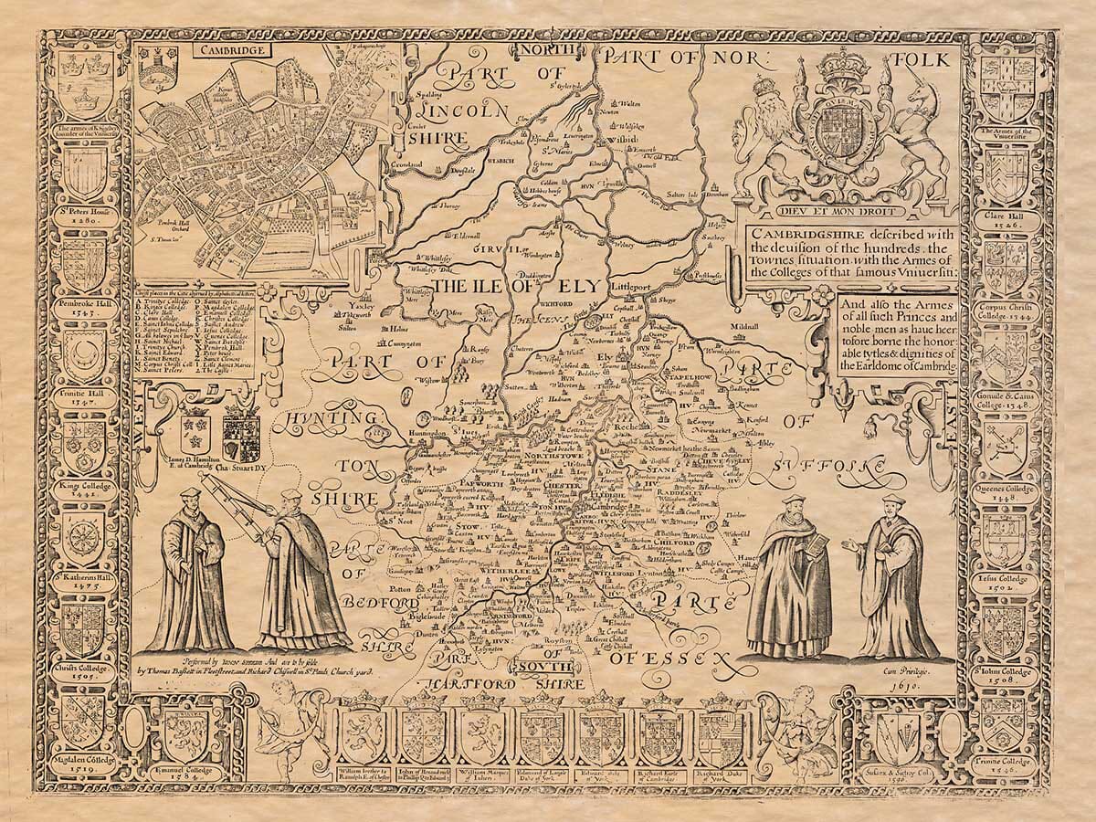
THE DESCRIPTION OF CAMBRIDGESHIRE.
CAMBRIDGESHIRE, written by the English Saxons, Grentbrigescire, lieth bounded upon the North with Lincoln-shire and Norfolk; upon the East with Norfolk and Suffolk; upon the South with Hartford-shire and Essex; and upon the West with Bedford and Huntingdon-shires.
(2) This Province is not large, nor for ayre greatly to be liked, having the Fens to spread upon her North, and lying neere the Sea for the rest: from whose furthermost point unto Roiston in the South, are five and thirty miles; but in the broadest it is not fully twenty: the whole in circumference, I recken, by the compasse of many indents, one hundred twenty and eight miles.
(3) The soile (both differing both in ayre and commodities:) the Fenny overcharged with waters: the South is Champion, and yieldeth Corne in abundance; with Meadowing and Pasture upon both sides of the River of Cam, which divideth that part of the Shire in the midst, upon whose East-bank, the Muses have built their most good Seat; who with plentious Nurserie, they have kindly continued for these many hundred yeares.
(4) For from ancient Grantchester, Cairgrant by Antoninus, now Cambridge, the other brest and nurse-mother of all pious literature, have flowed full streames of learning into all other parts of this Land and elsewhere: ancient indeed; if that storie be rightly written, that will have it built by Gurgunt a Spaniard, three hundred yeeres before the birth of our Saviour; who thither first brought and planted the Muses. This City Grant-bridge by the tyrannie of time hath lost her owne beauty and her professors admiration stained, so that in Bede’s daies, seven hundred yeeres after the Word became flesh, it is described to be a little olde Citie, and as yet retaineth the memorie onely of her walls, the height and compasse whereof may be seene.
Of this City, in the yeere of Christ 1114 (as the Monk of Bury writeth) some Scholars received their Baptisme, and became Preachers of the Gospell of Christ among the Britains; which happened in the Raigne of Hadrian the Emperour. But when the Picts, Scots, Hunnes and Saxons had laid all things waste, and with their savage sword cut our necks of learning, then this (as the rest) yeelded to destruction, and all lay forlorn till the Saxon times were called againe unto civill; when Sigebert the first Christian King of the East-Angles, from the example of France, whither he had been banished, built Schooles in his kingdome, and here at Grantchester the chief, recalling thither the Professors of Artes and Sciences, as the Story recordeth, and Traditions doe sound.
But afterwards, as it seemeth, by their increase being straightned, the Students complained (as the Prophets did of Elisha) that the place was too little for them; and then, in their enlarging more Northward, seated themselves neere unto the Bridge, whereupon the place began to be called Grant-bridge, though others from the crooked River Cam will have it named Cam-bridge. This place (though sacred, and exempted from Mars, as by some tokens (when the Dane invaded) the Danes in their cruelties regarded not, who, whether often wintered there their spoiles, and left the scars of their savage feeres over this Land: and in the yeere 1010, when Swaine in his fiercenesse had borne all in his bosome, this place was no place for Scholars to be in: It was not almost any where safe for men to live.
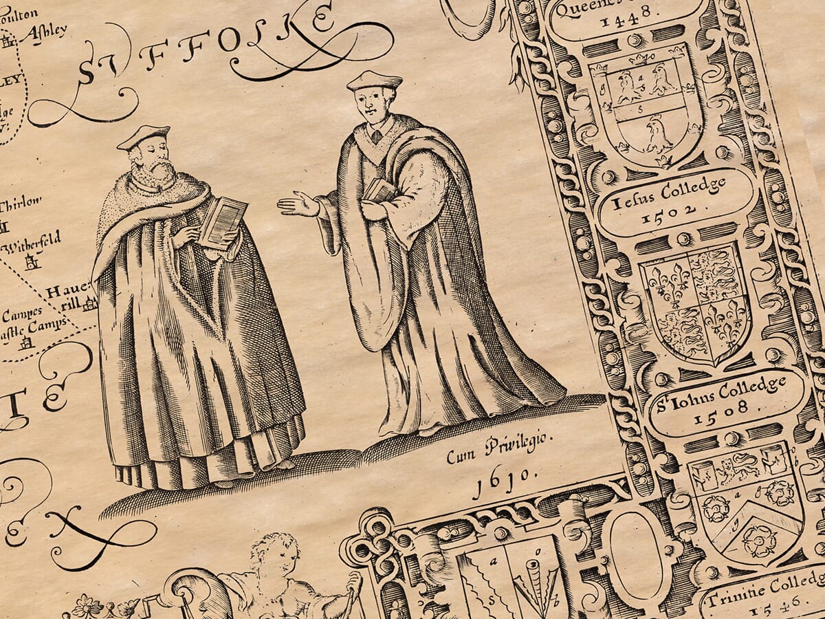
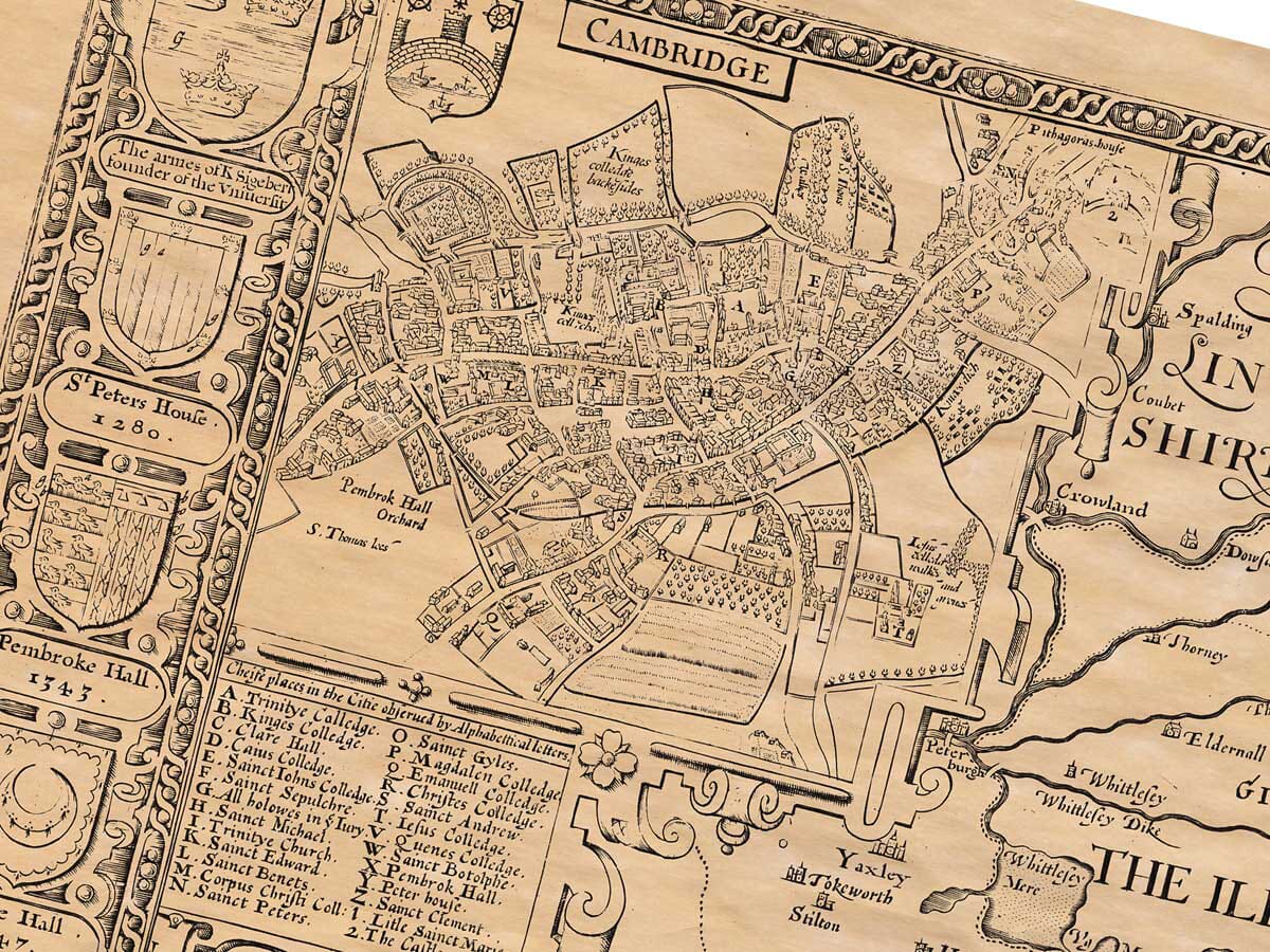
Yet when the Norman had the rule, and their head continued, and able Philip from Godstow into St. John’s Isle, Gilbert de Monks, with Odo, Jeremie, and Ralf his sonnes, after the like Monastical Professors, in the raigne of King Henry the first, fortified this little Island, and in a public Barn read the Liberal of Grammar, Logick, and Rhetorick, and Gilbert Divinity upon the Sabbath and Festival daies. From this little fountain (saith Peter Blesensis) grew a great River, which made all England plentiful, by the many Masters and Teachers proceeding out of Cambridge, as out of a holy Paradise of God. The first Colledge therein endowed with Possessions was Peter-house, built by Hugh Balsham Bishop of Ely, in the yeare of Grace 1284. Whose godly example many others followed; so that at this day there are sixteen most noble Colledges and Halls, for building, beauty, endowments, and store of Students to be admired, and, that unless it be in other ancient Cities, the like are not found in all Europe.
But at what time it was made an University, let Robert de Kenington tell you: he saith, that Pope John (helped by King Edward the first, Grandsires, of a School, by the Court of Rome, was made an University, such as Oxford is. Laity, the Meridian line cutting this Province neere this City, is distant from the furthest West-point, according to Mercator, 202 degrees, 50 scruples, and on the Arch of the same Meridian lying between the Equator and Tropicall-point, is 52 degrees, 20 scruples.
(5) Another City renowned in this Shire is Ely, by the Saxons Elge, had a name of the repletion and multitudes of Elyes (Eeles) that there were found: built by Audrey wife to Tonbert a Prince of Lyndsey: who in this place set a power of a Monastery: Having departed from her second Husband Ecgfrid King of Northumberland, devoted the rest of her time to Christ, and built here a Monastery, whereof she became the first Abbesse. This is that Audry whom the vulgar doth so often talk of; often said by Bedes words of Wincestre, who stood it with Monks; unto whom King Edgar granted the jurisdiction over four Hundreds and an half; within the Fens and the East-Angles limits, which to this day are called the Liberties of S. Audry: after whose dayes many Nobles of the Conqueror in large Revenues; that as Malmesbury saith, the Abbot lived in princely sort in Bishops-wise; and had great power and dominion. And of later times the Monks thereof became so wealthy, and that old decayed Church being new, rich and meetly adored, they kept within it.
N.B. We do not reproduce this verso on our editions.
The map includes and/or covers the locations of the following towns, villages and hamlets:
Abington Pigotts | ||||||||||||||||||||||||||||||||||||||||||||||||||||
Arrington | ||||||||||||||||||||||||||||||||||||||||||||||||||||
Ashley | ||||||||||||||||||||||||||||||||||||||||||||||||||||
Babraham | ||||||||||||||||||||||||||||||||||||||||||||||||||||
Balsham | ||||||||||||||||||||||||||||||||||||||||||||||||||||
Barrington | ||||||||||||||||||||||||||||||||||||||||||||||||||||
Barton | ||||||||||||||||||||||||||||||||||||||||||||||||||||
Bassingbourn | ||||||||||||||||||||||||||||||||||||||||||||||||||||
Bottisham | ||||||||||||||||||||||||||||||||||||||||||||||||||||
Bourn | ||||||||||||||||||||||||||||||||||||||||||||||||||||
Boxworth | ||||||||||||||||||||||||||||||||||||||||||||||||||||
Brinkley | ||||||||||||||||||||||||||||||||||||||||||||||||||||
Burrough Green | ||||||||||||||||||||||||||||||||||||||||||||||||||||
Burwell | ||||||||||||||||||||||||||||||||||||||||||||||||||||
Caldecote | ||||||||||||||||||||||||||||||||||||||||||||||||||||
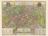
Cambridge | ||||||||||||||||||||||||||||||||||||||||||||||||||||
Carlton-cum-Willingham | ||||||||||||||||||||||||||||||||||||||||||||||||||||
Castle Camps | ||||||||||||||||||||||||||||||||||||||||||||||||||||
Chatteris | ||||||||||||||||||||||||||||||||||||||||||||||||||||
Cherry Hinton | ||||||||||||||||||||||||||||||||||||||||||||||||||||
Cheveley | ||||||||||||||||||||||||||||||||||||||||||||||||||||
Childerley
|
Landwade |
Leverington |
Linton |
Litlington |
Little Abington |
Little Eversden |
Little Gransden |
Little Shelford |
Little Wilbraham |
Littleport |
Lolworth |
Longstanton |
Longstowe |
Madingley |
Manea |
March |
Melbourn |
Meldreth |
Mepal |
Milton |
Newmarket All Saints |
Newton |
Oakington |
Orwell |
Outwell |
Over |
Pampisford |
Papworth Everard |
Papworth St Agnes |
Parson Drove |
Rampton |
Royston |
Sawston |
Shepreth |
Shingay |
Shudy Camps |
Snailwell |
Soham |
Stapleford |
Stetchworth |
Stow-cum-Quy |
Stretham |
Sutton |
Swaffham Bulbeck |
Swaffham Prior |
Swavesey |
Tadlow |
Teversham |
Thetford |
Thorney |
Thriplow |
Toft |
Trumpington |
Tydd St Giles |
Upwell |
Waterbeach |
Welches Dam |
Wentworth |
West Wickham |
West Wratting |
Westley Waterless |
Weston Colville |
Whaddon |
Whittlesey |
Whittlesford |
Wicken |
Wilburton |
Willingham |
Wimpole |
Wisbech |
Wisbech St Mary |
Witcham |
Witchford |
Wood Ditton |