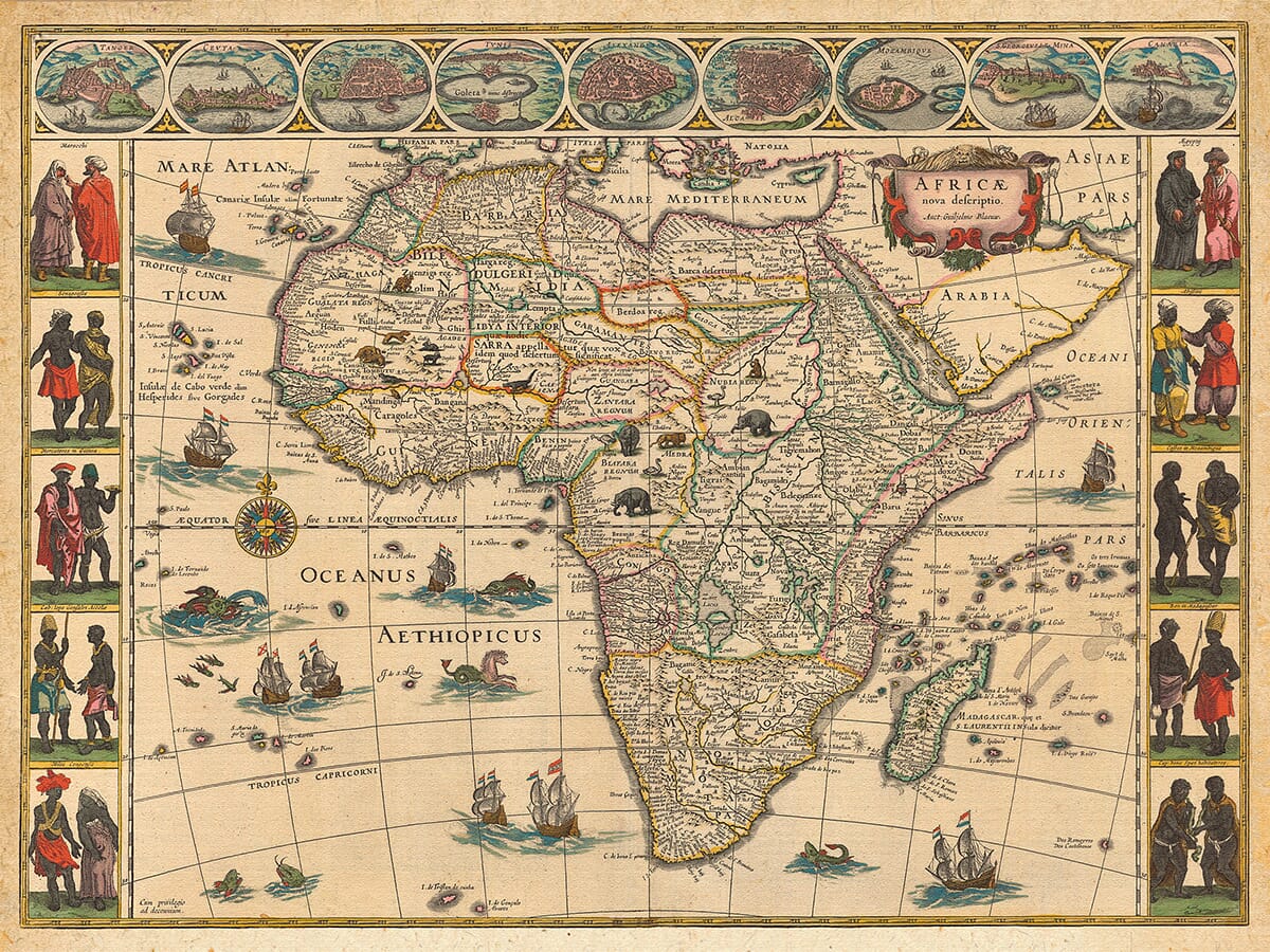
The Mapping of Africa
The evolution of maps and their role in human history has been remarkable. From basic navigational aids to geographically accurate depictions, maps have helped us understand the world. In this article, we explore the mapping of Africa, shedding light on early civilizations, challenges faced by cartographers, and the impact of European exploration and colonization.
Mapping in Early Civilizations
2.1 Mind maps and basic navigational aids
From the dawn of time, humans have created mental maps to remember directions and navigate their surroundings. These early forms of maps laid the foundation for future cartographic techniques.
2.2 The Babylonians and their town plan
One of the earliest surviving maps is the town plan of Nippur, created by the Babylonians around 1500 BC. This map, carved on a tablet, depicted the town walls, waterways, and important landmarks, showcasing the Babylonians’ fascination with mapmaking.
Challenges and Limitations of Early Maps
3.1 Scarcity of geographically accurate maps
Before the development of scientific resources and mathematical concepts, maps suffered from guesswork, misinformation, and interpretation, leading to inaccuracies and limited geographical accuracy.
3.2 Contributions of scientific resources and mathematical concepts
As scientific knowledge and mathematical concepts advanced, so did the accuracy of maps. Cartographers started incorporating scientific resources, correct ideas, and key mathematical concepts to create more precise maps.
Mapping the Unknown: Africa’s Interior
4.1 Limited knowledge of Africa’s interior
Historical maps reveal that the interior of Africa remained largely unknown until the later part of the 19th century. Explorers faced numerous challenges, including unfamiliar terrain and the threat of harm from local populations.
4.2 Exploration and discoveries by European explorers
Brave explorers such as Dr. Livingstone ventured into Africa’s uncharted lands, bringing back surveys, drawings, and groundbreaking revelations. Their firsthand observations and scientific documentation transformed the understanding of Africa’s interior.
Trade Routes and Cultural Exchange
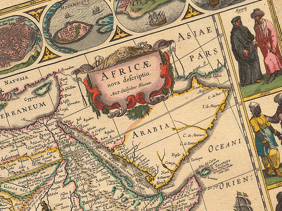
5.1 Mapping Africa’s coasts for trade routes
As trade routes developed, European cartographers began mapping the coasts of Africa. This facilitated cultural exchanges and trade between Europeans and Africans, leading to a better understanding of the coastal regions.
5.2 European exploration and local interactions
European explorers, while primarily focused on coastal regions, interacted with local tribes and gained second-hand knowledge of important landmarks. However, venturing further inland remained a daunting task due to various risks and challenges.
Mapping Africa’s Early History
6.1 Archaeological evidence and human evolution
Archaeological discoveries in Africa provide evidence of human evolution and early settlements. From mobile groups to settled societies, humans adapted to their environments, leaving behind traces of their existence.
6.2 Saharan rock art and its significance
Saharan rock art, such as petroglyphs dating back to 1500 BC, offers insights into the significance of cattle and the presence of ancient African societies. These enigmatic artworks provide clues about early African culture and symbolism.
Mapping Advancements and Claudius Ptolemy
7.1 The work of Claudius Ptolemy
Claudius Ptolemy, a Roman geographer and mathematician, made significant contributions to the field of cartography. His work, “The Geography,” combined mathematical knowledge with information from explorers to create highly accurate maps.
7.2 Inaccuracies in Ptolemy’s maps
While Ptolemy’s maps were groundbreaking for their time, they were not perfect. Notably, he placed the mythical “Mountains of the Moon” in the center of Africa, a misconception that remained uncorrected for centuries.
Mapping the Scramble for Africa
8.1 Increased exploration and colonization
In the late 19th century, European powers engaged in the “Scramble for Africa,” claiming territories and colonizing the continent. This period saw intensified exploration, leading to a rapid mapping of previously unexplored regions.
8.2 Cartographic consequences of European powers
European colonization had a profound impact on cartography. Borders were drawn, and maps from this era depict very little unexplored land in Africa. The lines on the map became symbolic of territorial claims and the scramble for resources.
Conclusion
The mapping of Africa has evolved over time, from rudimentary navigational aids to sophisticated and geographically accurate maps. Explorers, scientists, and cartographers have gradually unlocked the secrets of Africa’s vast and diverse landscapes. While challenges and inaccuracies persisted, their contributions have significantly shaped our understanding of the continent.
FAQs
How did early civilizations create maps without modern technology?
Early civilizations relied on mental maps, basic navigational aids, and simple sketches to depict their surroundings.
Who were some of the famous European explorers who ventured into Africa’s interior?
Dr. Livingstone, Richard Burton, John Speke, and James Grant are among the notable European explorers who ventured into Africa’s interior.
Did ancient Africans have a written language to accompany their maps?
Ancient Africans used various forms of communication, but written languages accompanying maps were not common.
How did the Scramble for Africa affect the cartographic depiction of the continent?
The Scramble for Africa led to increased exploration and rapid mapping, resulting in the delineation of borders and divisions between European colonies.
What impact did the colonization of Africa have on the continent’s indigenous societies?
The colonization of Africa had profound socio-cultural, economic, and political consequences for indigenous societies, leading to significant changes in their way of life.