1644 Willem Blaeu Africa Reproduction Map
A lovely and excellently embellished master-piece. From a hand coloured original it is both vibrant and fascinating in its detail. Carefully printed in house to order.
Available in two sizes:
Large: 24″ x 31″ (61 x 78.7cms) Medium: 18″ x 24″ (45.5 x 61cms)
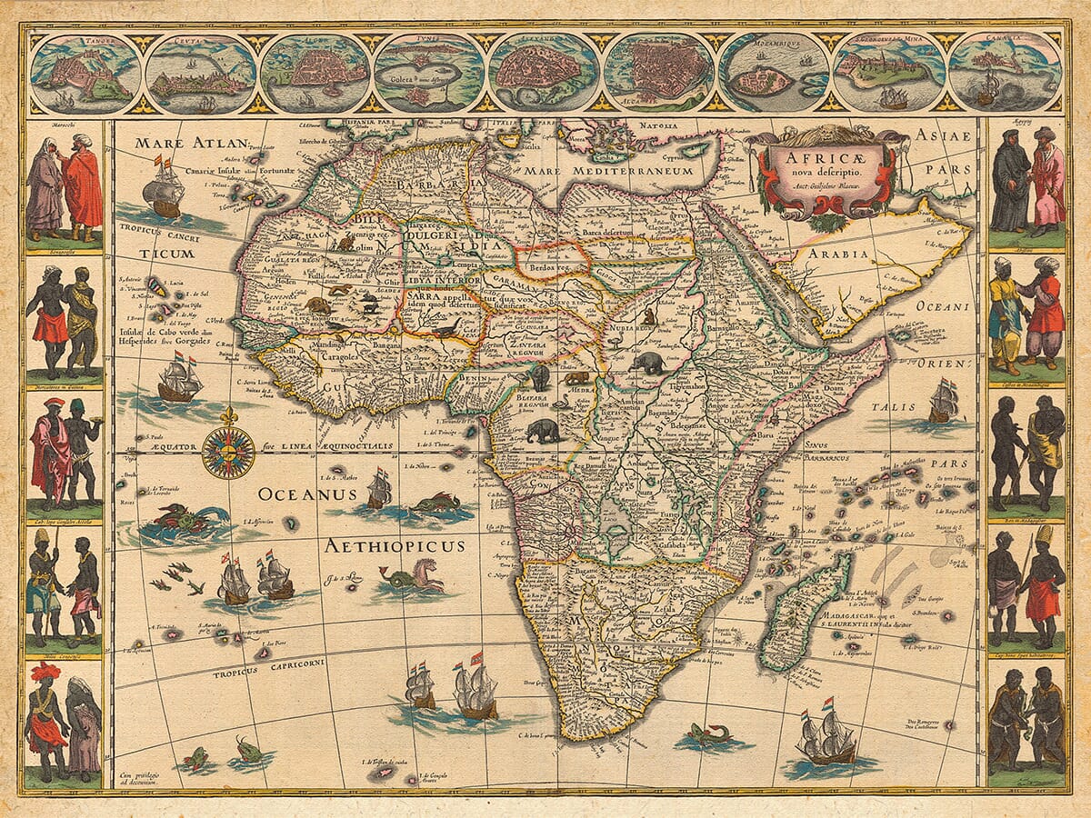
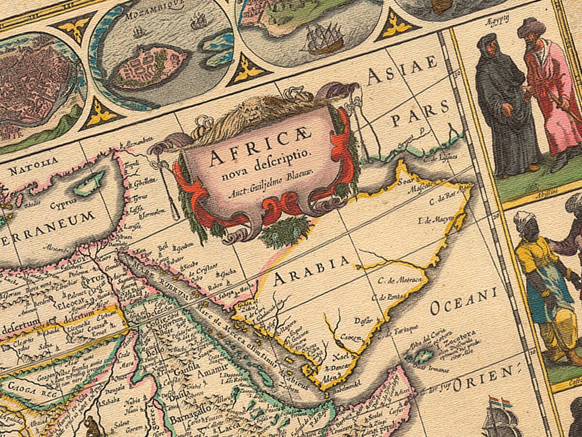
The 1644 Blaeu Map of Africa: A Masterpiece of Dutch Cartography
One of the most iconic and visually stunning early maps of Africa, Willem Janszoon Blaeu’s Africae nova descriptio is a significant artifact from the “golden age” of Dutch mapmaking. First published in 1630, this map was reprinted numerous times between 1631 and 1667, appearing in various editions of Blaeu’s renowned atlases in Latin, French, German, Dutch, and Spanish. The map is part of the second volume of Blaeu’s Le theatre du monde (Amsterdam, 1644), and it continues to be celebrated for its exquisite craftsmanship and intricate design.
Blaeu’s family business, which was carried on after his death by his sons Cornelis and Joan, was at the forefront of fine engraving and coloring during this era. Their atlases were unmatched in terms of their decorative appeal, elaborate cartouches, pictorial details, and elegant calligraphy, making them some of the most magnificent works of cartography ever produced.
The map is crafted in a style known as carte à figures, a format that combines detailed geography with artistic embellishments. It features a decorative outline of the African continent, showcasing various coastal cities and trading ports, including Tangier and Ceuta (Morocco), Tunis (Tunisia), Alexandria and Cairo (Egypt), Mozambique, Elmina (Ghana), and Grand Canary (Canary Islands). Each of these locations is represented by an oval view, offering an early glimpse of Africa’s key trade hubs.
The map’s side panels present costumed natives from the regions along the coasts, adding an exotic flair to the design. Inside the map, illustrations of wild animals—such as lions, elephants, and ostriches—decorate the interior, reflecting the fascination Europeans had with Africa’s fauna. The Nile River is shown flowing from the Ptolemaic lakes of Zaire and Zaflan, while flying fish and fantastical sea creatures swim through the surrounding oceans. Dutch sailing ships bearing the Dutch flag further reinforce the map’s connection to the Netherlands’ maritime power during the 17th century.
OUR GUARANTEE . . . YOU WILL NOT FIND A BETTER EDITION OF THIS MAP EITHER IN QUALITY OR VALUE . . . IF YOU ARE LESS THAN DELIGHTED WITH THIS MAP UPON RECEIPT YOU MAY RETURN IT FOR A FULL REFUND
Perhaps the most intriguing cartographic feature of this map is the representation of specific large territories or kingdoms, which are outlined in color. These include the vast regions of Abyssinia (Ethiopia) and Monomotapa (covering much of southern Africa). While these depictions suggest a European view of large, unified states, they were far removed from the reality of the continent’s complex political landscape. The regions shown in the map were still largely unexplored by European traders and explorers, and many smaller ethnic groups and political entities remained unknown to the cartographers of the time.
Despite these inaccuracies, the map is a product of its time, reflecting the European tendency to project a sense of nationhood upon unexplored territories. As a decorative and informative piece, Blaeu’s map not only provided Europeans with a visual representation of Africa but also captured the sense of wonder and mystery that surrounded the continent in the early 17th century.
Today, this map remains one of the most decorative and popular works of early African cartography, symbolizing both the achievements of Dutch mapmaking and the European fascination with Africa during the Age of Exploration. It serves as a reminder of the early efforts to map the world and the evolving understanding of distant lands, cultures, and peoples.